


GPS & Cycling Computers
 08-18-22, 12:12 PM
#1

Senior Member
Thread Starter
Join Date: Oct 2013
Location: Mich
Posts: 7,385
Bikes: RSO E-tire dropper fixie brifter
Mentioned: 0 Post(s)
Tagged: 0 Thread(s)
Quoted: 6 Post(s)
Liked 2,967 Times
in
1,916 Posts
GPS & Cycling Computers
I've not really put much thought into GPS & how it flows with the cycling computers, but after running into many instances where the once route that was a viable option became all of a sudden "closed" due to the orange barrels of doom I started to wonder.
Does the satellite that is broadcasting the GPS data to the bicycle computer contain up to date (within a handful of days) whereabouts regarding sidewalks, roads, MUPs? If it does, is it the bicycle's device that's slow to catch up?
It would be nice if there was an option to select a particular line art type for MUPs, slower speed zoned roads when just viewing the live map (not route) on the bicycle's computer.
__________________
-Oh Hey!
-Oh Hey!
 08-18-22, 12:17 PM
#2
Senior Member
Join Date: Sep 2007
Location: Far beyond the pale horizon.
Posts: 14,270
Mentioned: 31 Post(s)
Tagged: 0 Thread(s)
Quoted: 4254 Post(s)
Liked 1,353 Times
in
939 Posts
I've not really put much thought into GPS & how it flows with the cycling computers, but after running into many instances where the once route that was a viable option became all of a sudden "closed" due to the orange barrels of doom I started to wonder.
Does the satellite that is broadcasting the GPS data to the bicycle computer contain up to date (within a handful of days) whereabouts regarding sidewalks, roads, MUPs? If it does, is it the bicycle's device that's slow to catch up?
It would be nice if there was an option to select a particular line art type for MUPs, slower speed zoned roads when just viewing the live map (not route) on the bicycle's computer.
Does the satellite that is broadcasting the GPS data to the bicycle computer contain up to date (within a handful of days) whereabouts regarding sidewalks, roads, MUPs? If it does, is it the bicycle's device that's slow to catch up?
It would be nice if there was an option to select a particular line art type for MUPs, slower speed zoned roads when just viewing the live map (not route) on the bicycle's computer.
Maps don't get updated quickly and changes in the primary database have to filter down to the computer. Garmin updates its maps roughly twice a year.
Cycling computers usually have the map downloaded ahead of time. Navigation apps on your phone (like Google Maps) download the map data as it's needed (so you get the latest version). You can preload the maps (called "caching") with some of the phone apps. Relying on having continual internet access is not a good idea.
Speed limit data for roads is sparse. Roads are classified as motorways, trunk, primary, secondary, tertiary, residential. etc. That works as a rough guide to speed.
Last edited by njkayaker; 08-18-22 at 12:27 PM.

Likes For njkayaker:
08-18-22, 12:27 PM
#3
Senior Member
Join Date: Jul 2007
Location: South shore, L.I., NY
Posts: 6,880
Bikes: Flyxii FR322, Cannondale Topstone, Miyata City Liner, Specialized Chisel, Specialized Epic Evo
Mentioned: 18 Post(s)
Tagged: 0 Thread(s)
Quoted: 3237 Post(s)
Liked 2,082 Times
in
1,180 Posts
I've not really put much thought into GPS & how it flows with the cycling computers, but after running into many instances where the once route that was a viable option became all of a sudden "closed" due to the orange barrels of doom I started to wonder.
Does the satellite that is broadcasting the GPS data to the bicycle computer contain up to date (within a handful of days) whereabouts regarding sidewalks, roads, MUPs? If it does, is it the bicycle's device that's slow to catch up?
It would be nice if there was an option to select a particular line art type for MUPs, slower speed zoned roads when just viewing the live map (not route) on the bicycle's computer.
Does the satellite that is broadcasting the GPS data to the bicycle computer contain up to date (within a handful of days) whereabouts regarding sidewalks, roads, MUPs? If it does, is it the bicycle's device that's slow to catch up?
It would be nice if there was an option to select a particular line art type for MUPs, slower speed zoned roads when just viewing the live map (not route) on the bicycle's computer.
When you create a route in one of the route generation programs such as Ride With GPS, they give you routing options such as Cycling, or Driving, or Walking. Selecting one of those will have the route generation only route you onto roads, bike trails, or hiking trails, depending on which option you select. RWGPS does a pretty good job of showing you when you are on (Known) gravel roads, as example, it also shows you bike paths, as does Google Maps. I've never seen a map on an actual device break down and display the different types of roads and trails though. That has to be done in advance as part of the route creation software.
08-18-22, 12:30 PM
#4
Senior Member
Join Date: Sep 2007
Location: Far beyond the pale horizon.
Posts: 14,270
Mentioned: 31 Post(s)
Tagged: 0 Thread(s)
Quoted: 4254 Post(s)
Liked 1,353 Times
in
939 Posts
This site provides examples of different ways of doing that.
https://garmin.bbbike.org/
Likes For njkayaker:
08-18-22, 12:47 PM
#5
Senior Member
Join Date: Mar 2010
Location: Seattle, WA
Posts: 23,208
Mentioned: 89 Post(s)
Tagged: 0 Thread(s)
Quoted: 18883 Post(s)
Liked 10,646 Times
in
6,054 Posts
I've not really put much thought into GPS & how it flows with the cycling computers, but after running into many instances where the once route that was a viable option became all of a sudden "closed" due to the orange barrels of doom I started to wonder.
Does the satellite that is broadcasting the GPS data to the bicycle computer contain up to date (within a handful of days) whereabouts regarding sidewalks, roads, MUPs? If it does, is it the bicycle's device that's slow to catch up?
It would be nice if there was an option to select a particular line art type for MUPs, slower speed zoned roads when just viewing the live map (not route) on the bicycle's computer.
Does the satellite that is broadcasting the GPS data to the bicycle computer contain up to date (within a handful of days) whereabouts regarding sidewalks, roads, MUPs? If it does, is it the bicycle's device that's slow to catch up?
It would be nice if there was an option to select a particular line art type for MUPs, slower speed zoned roads when just viewing the live map (not route) on the bicycle's computer.
Likes For Seattle Forrest:
08-18-22, 12:55 PM
#6
Senior Member
Join Date: Mar 2010
Location: Seattle, WA
Posts: 23,208
Mentioned: 89 Post(s)
Tagged: 0 Thread(s)
Quoted: 18883 Post(s)
Liked 10,646 Times
in
6,054 Posts
No. Nothing keeps track of detours. The GPS signal is only telling the device it's position. No GPS cycling computer is able to keep up with any data base of road construction or detours. Car/truck/motorcycle specific devices might, not sure. There's no central reporting place for such info to go to. Google maps is arguably the best at it as it's constantly getting data from millions of phones using Google Maps as to location and speed, thus has the best crowd sourced information, but really only where there is congestion, not why.
When you create a route in one of the route generation programs such as Ride With GPS, they give you routing options such as Cycling, or Driving, or Walking. Selecting one of those will have the route generation only route you onto roads, bike trails, or hiking trails, depending on which option you select. RWGPS does a pretty good job of showing you when you are on (Known) gravel roads, as example, it also shows you bike paths, as does Google Maps. I've never seen a map on an actual device break down and display the different types of roads and trails though. That has to be done in advance as part of the route creation software.
When you create a route in one of the route generation programs such as Ride With GPS, they give you routing options such as Cycling, or Driving, or Walking. Selecting one of those will have the route generation only route you onto roads, bike trails, or hiking trails, depending on which option you select. RWGPS does a pretty good job of showing you when you are on (Known) gravel roads, as example, it also shows you bike paths, as does Google Maps. I've never seen a map on an actual device break down and display the different types of roads and trails though. That has to be done in advance as part of the route creation software.

Google Maps can warn you about speed traps.
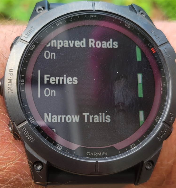
My Garmin watch has settings for routing, it can use or avoid unpaved roads and narrow (singletrack) trails.
 08-18-22, 01:08 PM
#7
Senior Member
I'm not sure about separate gps units but Google maps and other apps in your smartphone receives feedback from road users. So when a collision occurs or if a road or lane is closed due to construction, app determines if the best route is still the one with the slow traffic. Sometimes it is.
However, when I'm riding and come across those traffic cones, I visually scan ahead into the restricted area and check if I can ride safely in there ( ie no open pits to fall into). It's a bit of a refuge from busy traffic. But if I need to change lanes then it's also likely all those cars are also going pretty slowly too. So my merging into them and riding with them isn't anymore slower than they would be without me there.
However, when I'm riding and come across those traffic cones, I visually scan ahead into the restricted area and check if I can ride safely in there ( ie no open pits to fall into). It's a bit of a refuge from busy traffic. But if I need to change lanes then it's also likely all those cars are also going pretty slowly too. So my merging into them and riding with them isn't anymore slower than they would be without me there.
08-18-22, 01:35 PM
#8
Senior Member
Join Date: Sep 2007
Location: Far beyond the pale horizon.
Posts: 14,270
Mentioned: 31 Post(s)
Tagged: 0 Thread(s)
Quoted: 4254 Post(s)
Liked 1,353 Times
in
939 Posts
Separate GPS units lack the always-on high-speed data connection and the centralized server. (The Karoo has an option for a high-speed data connection but it doesn't use it like Google Maps does. The Karoo is just a smartphone, which means you could run Google Maps on it.)
However, when I'm riding and come across those traffic cones, I visually scan ahead into the restricted area and check if I can ride safely in there ( ie no open pits to fall into). It's a bit of a refuge from busy traffic. But if I need to change lanes then it's also likely all those cars are also going pretty slowly too. So my merging into them and riding with them isn't anymore slower than they would be without me there.
08-18-22, 01:39 PM
#9
Senior Member
Thread Starter
Join Date: Oct 2013
Location: Mich
Posts: 7,385
Bikes: RSO E-tire dropper fixie brifter
Mentioned: 0 Post(s)
Tagged: 0 Thread(s)
Quoted: 6 Post(s)
Liked 2,967 Times
in
1,916 Posts
I'm not sure about separate gps units but Google maps and other apps in your smartphone receives feedback from road users. So when a collision occurs or if a road or lane is closed due to construction, app determines if the best route is still the one with the slow traffic. Sometimes it is.
However, when I'm riding and come across those traffic cones, I visually scan ahead into the restricted area and check if I can ride safely in there ( ie no open pits to fall into). It's a bit of a refuge from busy traffic. But if I need to change lanes then it's also likely all those cars are also going pretty slowly too. So my merging into them and riding with them isn't anymore slower than they would be without me there.
However, when I'm riding and come across those traffic cones, I visually scan ahead into the restricted area and check if I can ride safely in there ( ie no open pits to fall into). It's a bit of a refuge from busy traffic. But if I need to change lanes then it's also likely all those cars are also going pretty slowly too. So my merging into them and riding with them isn't anymore slower than they would be without me there.
I do my best to forecast ahead while riding, & sometimes if I have a strong gut feeling that there's something I need to be aware of, I'll do a preroute check a day or so prior as best & close as I can get to the area. The problem I want to avoid is going down a twisty MUP a few miles & be faced with a "Closed road" sign right before the paved area drops off 16" into muck where comcast or such is digging. I think they could do better with a prewarning, but that may be too much to ask for (safety?)
Or be riding along on a road that quickly cuts thru some shady area of town & rely on a bridge to be accessible. Just to find out it was removed a few days prior & the detour signs that popped up within the 1/8 mile all point to a faster MPH road to take... If I had clearly known a mile sooner, I would have just took the much longer route, or changed gears entirely to ride elsewhere. That last example made some friends worried to my whereabouts when I wasn't even close to showing up on time & when I did, they were pretty much ready to call in a missing person's report. Good friends!
__________________
-Oh Hey!
-Oh Hey!
08-18-22, 01:44 PM
#10
Senior Member
Join Date: Sep 2007
Location: Far beyond the pale horizon.
Posts: 14,270
Mentioned: 31 Post(s)
Tagged: 0 Thread(s)
Quoted: 4254 Post(s)
Liked 1,353 Times
in
939 Posts
I do my best to forecast ahead while riding, & sometimes if I have a strong gut feeling that there's something I need to be aware of, I'll do a preroute check a day or so prior as best & close as I can get to the area. The problem I want to avoid is going down a twisty MUP a few miles & be faced with a "Closed road" sign right before the paved area drops off 16" into muck where comcast or such is digging. I think they could do better with a prewarning, but that may be too much to ask for (safety?)
And, there are situations where the detour prevents driving but not cycling (even if you have to walk).
Maybe, you should have called them.
Last edited by njkayaker; 08-18-22 at 01:49 PM.
08-18-22, 03:58 PM
#11
I'm good to go!
Join Date: Jul 2017
Location: Mississippi
Posts: 14,985
Bikes: Tarmac Disc Comp Di2 - 2020
Mentioned: 51 Post(s)
Tagged: 0 Thread(s)
Quoted: 6193 Post(s)
Liked 4,808 Times
in
3,316 Posts
Unless the road is closed for construction, a washout or for reasons that involve miles of closed road, on a bike you ought to be able to get around what ever it is that temporarily closed the road. Even a road bike can go off road in many places. If not, put the top tube over your shoulder and hoof it.
Likes For bikehoco:
08-18-22, 04:41 PM
#13
Senior Member
Join Date: Mar 2010
Location: Seattle, WA
Posts: 23,208
Mentioned: 89 Post(s)
Tagged: 0 Thread(s)
Quoted: 18883 Post(s)
Liked 10,646 Times
in
6,054 Posts
Unless the road is closed for construction, a washout or for reasons that involve miles of closed road, on a bike you ought to be able to get around what ever it is that temporarily closed the road. Even a road bike can go off road in many places. If not, put the top tube over your shoulder and hoof it.
Likes For Seattle Forrest:
08-18-22, 04:54 PM
#14
Senior Member
Join Date: Sep 2007
Location: Far beyond the pale horizon.
Posts: 14,270
Mentioned: 31 Post(s)
Tagged: 0 Thread(s)
Quoted: 4254 Post(s)
Liked 1,353 Times
in
939 Posts
Overly melodramatic. There are many cases where it's fine to do (even set up to allow it).
There is a wide range of possibilities between an open road and flaming death.
It's not likely that Iride01 is suggesting not taking reasonable care.
I've come across numerous cases where the road was closed (impassible) for cars and fine for bicycles/walking. In some cases, these were set up for walking.
08-18-22, 05:01 PM
#15
Senior Member
Join Date: Mar 2010
Location: Seattle, WA
Posts: 23,208
Mentioned: 89 Post(s)
Tagged: 0 Thread(s)
Quoted: 18883 Post(s)
Liked 10,646 Times
in
6,054 Posts
They don't close roads right at the spot that's dangerous. When an area is closed for fire activity, just being there puts other people's lives in danger and carries very high penalties because of it. Don't be an irresponsible Darwin award contender.
08-18-22, 05:05 PM
#16
Senior Member
Join Date: Sep 2007
Location: Far beyond the pale horizon.
Posts: 14,270
Mentioned: 31 Post(s)
Tagged: 0 Thread(s)
Quoted: 4254 Post(s)
Liked 1,353 Times
in
939 Posts
It depends on the closure.
In some cases, you can see the reason for the closure and even see the official pedestrian access.
If you can't see why there is a closure, it would be reasonable not to continue.
I suspect Iride01 isn't considering the types of closures you are and you aren't considering the types of closures he is. It would be more useful to shed light on that than make a blanket statements about being "irresponsible" (which no one was suggesting to do).
(Iride01 doesn't come across as reckless/careless. I doubt he was recommending being reckless/careless here.)
Last edited by njkayaker; 08-18-22 at 05:32 PM.
08-18-22, 05:48 PM
#17
I'm good to go!
Join Date: Jul 2017
Location: Mississippi
Posts: 14,985
Bikes: Tarmac Disc Comp Di2 - 2020
Mentioned: 51 Post(s)
Tagged: 0 Thread(s)
Quoted: 6193 Post(s)
Liked 4,808 Times
in
3,316 Posts
08-18-22, 05:50 PM
#18
Senior Member
Join Date: Jul 2007
Location: South shore, L.I., NY
Posts: 6,880
Bikes: Flyxii FR322, Cannondale Topstone, Miyata City Liner, Specialized Chisel, Specialized Epic Evo
Mentioned: 18 Post(s)
Tagged: 0 Thread(s)
Quoted: 3237 Post(s)
Liked 2,082 Times
in
1,180 Posts
08-18-22, 05:52 PM
#19
I'm good to go!
Join Date: Jul 2017
Location: Mississippi
Posts: 14,985
Bikes: Tarmac Disc Comp Di2 - 2020
Mentioned: 51 Post(s)
Tagged: 0 Thread(s)
Quoted: 6193 Post(s)
Liked 4,808 Times
in
3,316 Posts
Well I didn't know I had to add every if and or but to that advice. Of course you have to evaluate what it is that is closing the road and how safe it is to go around.
But your comment is simply wrong. Many times when roads are closed, they are only closed for motor vehicle traffic.
But your comment is simply wrong. Many times when roads are closed, they are only closed for motor vehicle traffic.
08-18-22, 06:03 PM
#20
Senior Member
Join Date: Aug 2010
Location: Madison, WI
Posts: 11,203
Bikes: 1961 Ideor, 1966 Perfekt 3 Speed AB Hub, 1994 Bridgestone MB-6, 2006 Airnimal Joey, 2009 Thorn Sherpa, 2013 Thorn Nomad MkII, 2015 VO Pass Hunter, 2017 Lynskey Backroad, 2017 Raleigh Gran Prix, 1980s Bianchi Mixte on a trainer. Others are now gone.
Mentioned: 48 Post(s)
Tagged: 0 Thread(s)
Quoted: 3459 Post(s)
Liked 1,465 Times
in
1,143 Posts
I have lived in my community long enough to know that the sign crew often puts up the road closed signs a few days before the construction starts and often takes the signs down days after they are done. Even driving a vehicle, I occasionally risk that it is not really closed.
Road closures, reasons vary and surrounding terrain varies. If they are replacing the pavement on a road or bike path in a rural area, you often have no choice and need to detour to a different route. This is especially true with bridges.
On the other hand in urban areas, if they are tearing up a road, you might be able to get around the construction site by riding or walking your bike on sidewalks, etc. A couple months ago I went through a sizeable construction area without any difficulty by staying on sidewalks with my bike. Never got near any of the equipment tearing up the road to lay new utilities under the road.
Some of this is common sense, but sometimes I wonder how commonplace common sense really is.
08-18-22, 06:55 PM
#21
Senior Member
Thread Starter
Join Date: Oct 2013
Location: Mich
Posts: 7,385
Bikes: RSO E-tire dropper fixie brifter
Mentioned: 0 Post(s)
Tagged: 0 Thread(s)
Quoted: 6 Post(s)
Liked 2,967 Times
in
1,916 Posts
There is some standard reporting for detours/construction. Using something like Google maps is going to be your only option for this sort of information. But it's not going to be perfect. Especially for routes that aren't used by cars.
And, there are situations where the detour prevents driving but not cycling (even if you have to walk).
And, there are situations where the detour prevents driving but not cycling (even if you have to walk).
The particular area, I wasn't going to become a distracted/sitting duck.
The construction work around here lacks planning for peds. They also like to compound construction by adding more work on top of work creating a lot more congestion.
__________________
-Oh Hey!
-Oh Hey!
08-19-22, 08:19 AM
#23
Senior Member
Join Date: Dec 2010
Location: northern Deep South
Posts: 8,901
Bikes: Fuji Touring, Novara Randonee
Mentioned: 36 Post(s)
Tagged: 0 Thread(s)
Quoted: 2604 Post(s)
Liked 1,928 Times
in
1,210 Posts
 08-19-22, 09:43 AM
#24
I'm good to go!
Join Date: Jul 2017
Location: Mississippi
Posts: 14,985
Bikes: Tarmac Disc Comp Di2 - 2020
Mentioned: 51 Post(s)
Tagged: 0 Thread(s)
Quoted: 6193 Post(s)
Liked 4,808 Times
in
3,316 Posts
A while back they had a seven mile stretch of the Natchez trace closed. Only about a 1000 feet of it was where there was actual construction going on. And the majority of that was shoulder work to support a fifty or sixty foot high embankment that was beginning to slide and endangering the road that above it. The work crews had even barricaded off the work area in such a way to give sufficient room for cyclist to pass through safely.
Those cyclist heeding the road closure notices from google or elsewhere missed out on some of the best weeks of riding on the Natchez Trace unhindered by motor traffic. Indeed the signs on the barricades at both ends specifically said the road was only closed to motor vehicles.
If' I'd not been so
I would have missed out on some great riding.
And I have found other situations since where road closures are perfectly safe for other than motor vehicles and the authorities closing the road agreeing.
Those cyclist heeding the road closure notices from google or elsewhere missed out on some of the best weeks of riding on the Natchez Trace unhindered by motor traffic. Indeed the signs on the barricades at both ends specifically said the road was only closed to motor vehicles.
If' I'd not been so
Dangerous, irresponsible
And I have found other situations since where road closures are perfectly safe for other than motor vehicles and the authorities closing the road agreeing.
08-19-22, 11:20 AM
#25
Senior Member
Join Date: Apr 2015
Location: Georgia
Posts: 654
Mentioned: 0 Post(s)
Tagged: 0 Thread(s)
Quoted: 236 Post(s)
Liked 196 Times
in
130 Posts
FWIW, the GPS satellites also broadcast the ephemeris - the orbit info for the satellites - which the GPS receiver needs in order to calculate its location. Typically today connected devices will update the ephemeris via the internet rather than the (slower/older) method of receiving it from the satellites.
Likes For gpburdell: