


Route Planner
 05-14-23, 08:33 AM
#1
Newbie
Thread Starter
Join Date: Apr 2022
Posts: 8
Mentioned: 0 Post(s)
Tagged: 0 Thread(s)
Quoted: 10 Post(s)
Liked 0 Times
in
0 Posts
Route Planner
Hey guys, I want to plan my first long distance bike tour, from Turin (Italy) to Bern (Switzerland). Unfortunately, I don't know anything about route planning. Can anyone help me to know what software I need to use? I have Garmin 1040. I don't know if I need to use Komoot, or garmin basecamp or any other software.
I tried Komoot, but how can I exclude highways same as garmin device? Or how can I choose another route with less elevation?
imgur.com/VIs4dko.png
I tried Komoot, but how can I exclude highways same as garmin device? Or how can I choose another route with less elevation?
imgur.com/VIs4dko.png
 05-14-23, 08:43 AM
#2
Senior Member
Join Date: Mar 2010
Posts: 1,659
Mentioned: 7 Post(s)
Tagged: 0 Thread(s)
Quoted: 1248 Post(s)
Liked 1,323 Times
in
674 Posts
Hey guys, I want to plan my first long distance bike tour, from Turin (Italy) to Bern (Switzerland). Unfortunately, I don't know anything about route planning. Can anyone help me to know what software I need to use? I have Garmin 1040. I don't know if I need to use Komoot, or garmin basecamp or any other software.
I tried Komoot, but how can I exclude highways same as garmin device? Or how can I choose another route with less elevation?
imgur.com/VIs4dko.png
I tried Komoot, but how can I exclude highways same as garmin device? Or how can I choose another route with less elevation?
imgur.com/VIs4dko.png
Likes For Atlas Shrugged:
05-14-23, 10:43 AM
#3
bicycle tourist
A few thoughts on route planning and what I've with similar exercises recently:
1. One of the first things I do is search to see if someone already has done a similar route. I look at sites like crazyguyonabike since then I'll find a journal that describes their trip as well.
2. The next thing I'll do for a longer distance (Google tells me 300+ km from Bern to Turin), is get an overview using a map, either paper or sometimes try Google Maps with either driving + avoid tolls/highways. I am not looking for a specific turn by turn directions but instead getting an overview of different cities/towns I might visit and how to break the trip into smaller pieces. This also gives me a rough "time budget" of how many days I anticipate taking
3. When I have things into smaller parts, often riding for a particular day might be fairly obvious, e.g. follow this road until that town, then the next road...
4. At the next level smaller, I have recently experimented with different planning tools. These tools sometimes behave differently in different countries or in areas with many roads (e.g. cities) and few choices. Here are some tradeoffs I have found trying different ones:
a. Google Maps bicycle directions gives me elevation gains. However, it also seems to pick up random small trails including unpaved routes
b. Google Maps driving directions without highways/tolls stays more on paved routes and avoids bike paths. For a lot of the US I prefer it to cycling directions.
c. Komoot is a recent favorite of mine. It lets you specify a sport, e.g. road cycling or gravel riding or mountain biking or bike touring ... that controls the types of routes picked. I've been pleased with routes it picked across many large US cities (e.g. New York, Boston, Baltimore, Washington DC) on my recent trip.
d. RideWithGPS shows you both the road surface (paved or unpaved) and shows you heat maps. It has fewer choices e.g. driving or cycling. I find it more tedious to adjust routes than Komoot choices so I didn't like it as well crossing US cities than Komoot.
In summary, I tend to plan from large scale to smaller parts:
1. Journals or overview maps to establish a time budget and break the trip into smaller pieces.
2. Maps or planning tool to look at routes smaller than a single day.
Likes For mev:
05-14-23, 10:50 AM
#4
bicycle tourist
I find the PC version easier for dragging the entire route to see what it does for elevation profiles. On the phone app, I put in waypoints to help guide alternative choices.
As far as excluding highways goes, I found that comes by picking the sport. Sometimes that exclusion works almost too well. As an example, US 6 is a major highway in Connecticut and parts are not allowed for bicycles. However, both Komoot and RideWithGPS seemed to also avoid US 6 in some rural CT areas while Google Maps more easily picked this road.
Likes For mev:
05-14-23, 03:30 PM
#5
Senior Member
Join Date: Jan 2010
Posts: 39,232
Mentioned: 211 Post(s)
Tagged: 1 Thread(s)
Quoted: 18410 Post(s)
Liked 15,530 Times
in
7,326 Posts
Anyone know if the unpaved road data of RWGPS has gotten better than it was originally? When it was first introduced I experienced many inaccuracies. Paved roads it indicated were unpaved and vice-versa.
That aside, I follow several steps suggested by mev.
That aside, I follow several steps suggested by mev.
Likes For indyfabz:
05-14-23, 06:13 PM
#6
Senior Member
Join Date: Sep 2007
Location: Far beyond the pale horizon.
Posts: 14,271
Mentioned: 31 Post(s)
Tagged: 0 Thread(s)
Quoted: 4254 Post(s)
Liked 1,354 Times
in
940 Posts
The default map is Google.
The alternative map is Openstreetmap (OSM).
The 1040 (and other recent models) use OSM maps.

Likes For njkayaker:
05-15-23, 06:38 AM
#7
Newbie
Thread Starter
Join Date: Apr 2022
Posts: 8
Mentioned: 0 Post(s)
Tagged: 0 Thread(s)
Quoted: 10 Post(s)
Liked 0 Times
in
0 Posts
A few thoughts on route planning and what I've with similar exercises recently:
1. One of the first things I do is search to see if someone already has done a similar route. I look at sites like crazyguyonabike since then I'll find a journal that describes their trip as well.
2. The next thing I'll do for a longer distance (Google tells me 300+ km from Bern to Turin), is get an overview using a map, either paper or sometimes try Google Maps with either driving + avoid tolls/highways. I am not looking for a specific turn by turn directions but instead getting an overview of different cities/towns I might visit and how to break the trip into smaller pieces. This also gives me a rough "time budget" of how many days I anticipate taking
3. When I have things into smaller parts, often riding for a particular day might be fairly obvious, e.g. follow this road until that town, then the next road...
4. At the next level smaller, I have recently experimented with different planning tools. These tools sometimes behave differently in different countries or in areas with many roads (e.g. cities) and few choices. Here are some tradeoffs I have found trying different ones:
a. Google Maps bicycle directions gives me elevation gains. However, it also seems to pick up random small trails including unpaved routes
b. Google Maps driving directions without highways/tolls stays more on paved routes and avoids bike paths. For a lot of the US I prefer it to cycling directions.
c. Komoot is a recent favorite of mine. It lets you specify a sport, e.g. road cycling or gravel riding or mountain biking or bike touring ... that controls the types of routes picked. I've been pleased with routes it picked across many large US cities (e.g. New York, Boston, Baltimore, Washington DC) on my recent trip.
d. RideWithGPS shows you both the road surface (paved or unpaved) and shows you heat maps. It has fewer choices e.g. driving or cycling. I find it more tedious to adjust routes than Komoot choices so I didn't like it as well crossing US cities than Komoot.
In summary, I tend to plan from large scale to smaller parts:
1. Journals or overview maps to establish a time budget and break the trip into smaller pieces.
2. Maps or planning tool to look at routes smaller than a single day.
1. One of the first things I do is search to see if someone already has done a similar route. I look at sites like crazyguyonabike since then I'll find a journal that describes their trip as well.
2. The next thing I'll do for a longer distance (Google tells me 300+ km from Bern to Turin), is get an overview using a map, either paper or sometimes try Google Maps with either driving + avoid tolls/highways. I am not looking for a specific turn by turn directions but instead getting an overview of different cities/towns I might visit and how to break the trip into smaller pieces. This also gives me a rough "time budget" of how many days I anticipate taking
3. When I have things into smaller parts, often riding for a particular day might be fairly obvious, e.g. follow this road until that town, then the next road...
4. At the next level smaller, I have recently experimented with different planning tools. These tools sometimes behave differently in different countries or in areas with many roads (e.g. cities) and few choices. Here are some tradeoffs I have found trying different ones:
a. Google Maps bicycle directions gives me elevation gains. However, it also seems to pick up random small trails including unpaved routes
b. Google Maps driving directions without highways/tolls stays more on paved routes and avoids bike paths. For a lot of the US I prefer it to cycling directions.
c. Komoot is a recent favorite of mine. It lets you specify a sport, e.g. road cycling or gravel riding or mountain biking or bike touring ... that controls the types of routes picked. I've been pleased with routes it picked across many large US cities (e.g. New York, Boston, Baltimore, Washington DC) on my recent trip.
d. RideWithGPS shows you both the road surface (paved or unpaved) and shows you heat maps. It has fewer choices e.g. driving or cycling. I find it more tedious to adjust routes than Komoot choices so I didn't like it as well crossing US cities than Komoot.
In summary, I tend to plan from large scale to smaller parts:
1. Journals or overview maps to establish a time budget and break the trip into smaller pieces.
2. Maps or planning tool to look at routes smaller than a single day.
So, first question is that Garmin itself, provides me good routes when I'm on my bike. But it doesn't have any route planner or some similar tool that I can see the complete route on my laptop to review it? That's why we have to use another tool such as Komoot for this feature? I found something called as garmin basecamp, not sure if this is what I need, because I couldn't figure out how it works. I need to search though.
In garmin, we can also select what kind of cycling we are doing, for example road, touring, gravel .... And we can also select which type of roads. For example for touring, MAJOR HIGHWAY option is enabled which I have disabled it. But as you said, it seems Komoot itself handles this and we can't change except type of activity and it automatically excludes it.
Now, I just entered the info in komoot route planner, and it gives me this graph. I'm really noob at this, how can I know if I can handle the difficulty of this path?
imgur.com/s4H8F4Q.png
In general, I have 2 concerns:
1. Maybe in my trip, there is an uphill with high degree slope which I can't pass it.
2. Maybe it's a road without possibility for bikes to pass.
How can I avoid these?
Thanks
Last edited by repentersprite; 05-15-23 at 06:54 AM.
05-15-23, 08:40 AM
#8
Senior Member
Join Date: Aug 2010
Location: Madison, WI
Posts: 11,203
Bikes: 1961 Ideor, 1966 Perfekt 3 Speed AB Hub, 1994 Bridgestone MB-6, 2006 Airnimal Joey, 2009 Thorn Sherpa, 2013 Thorn Nomad MkII, 2015 VO Pass Hunter, 2017 Lynskey Backroad, 2017 Raleigh Gran Prix, 1980s Bianchi Mixte on a trainer. Others are now gone.
Mentioned: 48 Post(s)
Tagged: 0 Thread(s)
Quoted: 3459 Post(s)
Liked 1,465 Times
in
1,143 Posts
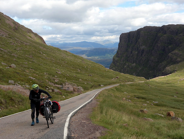
I knew months ahead of my tour that I was going to walk my bike up this hill, I can't pedal up a 13 percent grade that runs for several kilometers.

I spent maybe an hour walking my bike up that hill, but an hour is only a small part of the traveling I do in a day. Steep hills are a fact of life. Accept that and don't worry about it.
Likes For Tourist in MSN:
05-15-23, 10:49 AM
#9
bicycle tourist
I don't know about Garmin Basecamp. From the description - https://www.garmin.com/en-US/software/basecamp/ it looks like it might have some similar features as Komoot or RideWithGPS
Here is what I do to connect things:
* There is an app named Garmin Connect that I use to download routes to my Garmin device. This also works together with RideWithGPS or with Komoot. So I'll create routes in Komoot (typically on my phone or my PC) or with RideWithGPS (typically on my PC). I save those routes and then transfer them as courses to my Garmin 540 or Garmin 1030.
Now as far as how suitable these routes are for road choices or steep climbs. I am willing to ride on sometimes busier roads and have found neither app will pick roads where bicycles are not allowed. Komoot does have a difficulty level you can pick and I believe if you end up with "easy" this may also affect the choices. In RideWithGPS you can see a "heat map" where others have cycled. While that doesn't necessarily mean flat and no traffic, it does tell you choices others make.
Now as far as steep hills go. There are two different scales here: short hills that might be very steep and longer hills that are also steep.
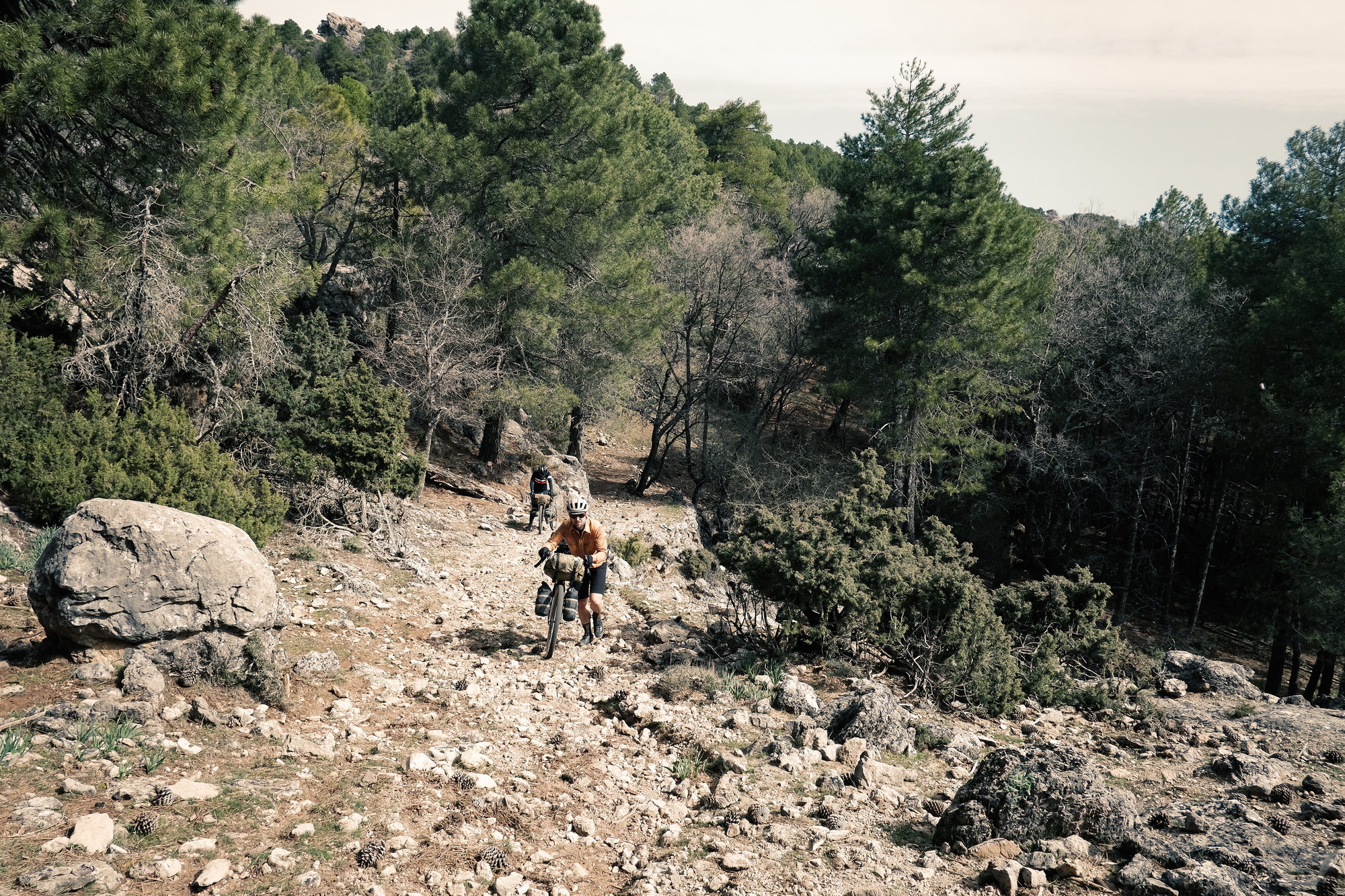
I'm not sure it is easy to find the short steep hills. However, these don't concern me as much because if needed I will walk up them. The longer steep hills are visible enough to see on the elevation profiles in the app.
Here is what I do to connect things:
* There is an app named Garmin Connect that I use to download routes to my Garmin device. This also works together with RideWithGPS or with Komoot. So I'll create routes in Komoot (typically on my phone or my PC) or with RideWithGPS (typically on my PC). I save those routes and then transfer them as courses to my Garmin 540 or Garmin 1030.
Now as far as how suitable these routes are for road choices or steep climbs. I am willing to ride on sometimes busier roads and have found neither app will pick roads where bicycles are not allowed. Komoot does have a difficulty level you can pick and I believe if you end up with "easy" this may also affect the choices. In RideWithGPS you can see a "heat map" where others have cycled. While that doesn't necessarily mean flat and no traffic, it does tell you choices others make.
Now as far as steep hills go. There are two different scales here: short hills that might be very steep and longer hills that are also steep.
I'm not sure it is easy to find the short steep hills. However, these don't concern me as much because if needed I will walk up them. The longer steep hills are visible enough to see on the elevation profiles in the app.
Likes For mev:
05-15-23, 11:58 AM
#10
Palmer

Join Date: Mar 2007
Location: Parts Unknown
Posts: 8,621
Bikes: Mike Melton custom, Alex Moulton AM, Dahon Curl
Mentioned: 37 Post(s)
Tagged: 0 Thread(s)
Quoted: 1663 Post(s)
Liked 1,817 Times
in
1,057 Posts
Likes For tcs:
05-15-23, 12:08 PM
#11
Palmer
Join Date: Mar 2007
Location: Parts Unknown
Posts: 8,621
Bikes: Mike Melton custom, Alex Moulton AM, Dahon Curl
Mentioned: 37 Post(s)
Tagged: 0 Thread(s)
Quoted: 1663 Post(s)
Liked 1,817 Times
in
1,057 Posts


Likes For tcs:
05-15-23, 12:18 PM
#12
Palmer
Join Date: Mar 2007
Location: Parts Unknown
Posts: 8,621
Bikes: Mike Melton custom, Alex Moulton AM, Dahon Curl
Mentioned: 37 Post(s)
Tagged: 0 Thread(s)
Quoted: 1663 Post(s)
Liked 1,817 Times
in
1,057 Posts
Likes For tcs:

Likes For str:
05-17-23, 11:01 AM
#16
Senior Member
Join Date: Sep 2007
Location: Far beyond the pale horizon.
Posts: 14,271
Mentioned: 31 Post(s)
Tagged: 0 Thread(s)
Quoted: 4254 Post(s)
Liked 1,354 Times
in
940 Posts
Keep in mind that there are two "layers" when using maps (on RWGPS): 1- the stuff you see; 2- the routing map. One can use difference sources for these two maps.
The ESRI Topo, USGS Topo, and USGS Scans are different maps. It looks like these use OSM for routing.
"Map", "Terrain", "Satellite", "Hybrid" use Google data (for image and routing).
Note that you can switch between maps when creating a route. That is, once in a while one map is missing something while another isn't.
Last edited by njkayaker; 05-17-23 at 11:15 AM.
Likes For njkayaker:
05-17-23, 12:08 PM
#17
Senior Member
Join Date: Sep 2013
Location: Spain
Posts: 1,065
Mentioned: 4 Post(s)
Tagged: 0 Thread(s)
Quoted: 272 Post(s)
Liked 487 Times
in
236 Posts
It's the same but has cycle ways highlighted. The "RWGPS" map appears to be OSM data too (with cycle ways highlighted).
Keep in mind that there are two "layers" when using maps (on RWGPS): 1- the stuff you see; 2- the routing map. One can use difference sources for these two maps.
The ESRI Topo, USGS Topo, and USGS Scans are different maps. It looks like these use OSM for routing.
"Map", "Terrain", "Satellite", "Hybrid" use Google data (for image and routing).
Note that you can switch between maps when creating a route. That is, once in a while one map is missing something while another isn't.
thanks, I know most of it. plan all my routes with ridewithgps.

 05-18-23, 06:03 PM
#19
Palmer
Join Date: Mar 2007
Location: Parts Unknown
Posts: 8,621
Bikes: Mike Melton custom, Alex Moulton AM, Dahon Curl
Mentioned: 37 Post(s)
Tagged: 0 Thread(s)
Quoted: 1663 Post(s)
Liked 1,817 Times
in
1,057 Posts

