


RWGPS Paved/Unpaved Modality
 08-17-21, 11:50 PM
#1

Hooked on Touring
Thread Starter
RWGPS Paved/Unpaved Modality
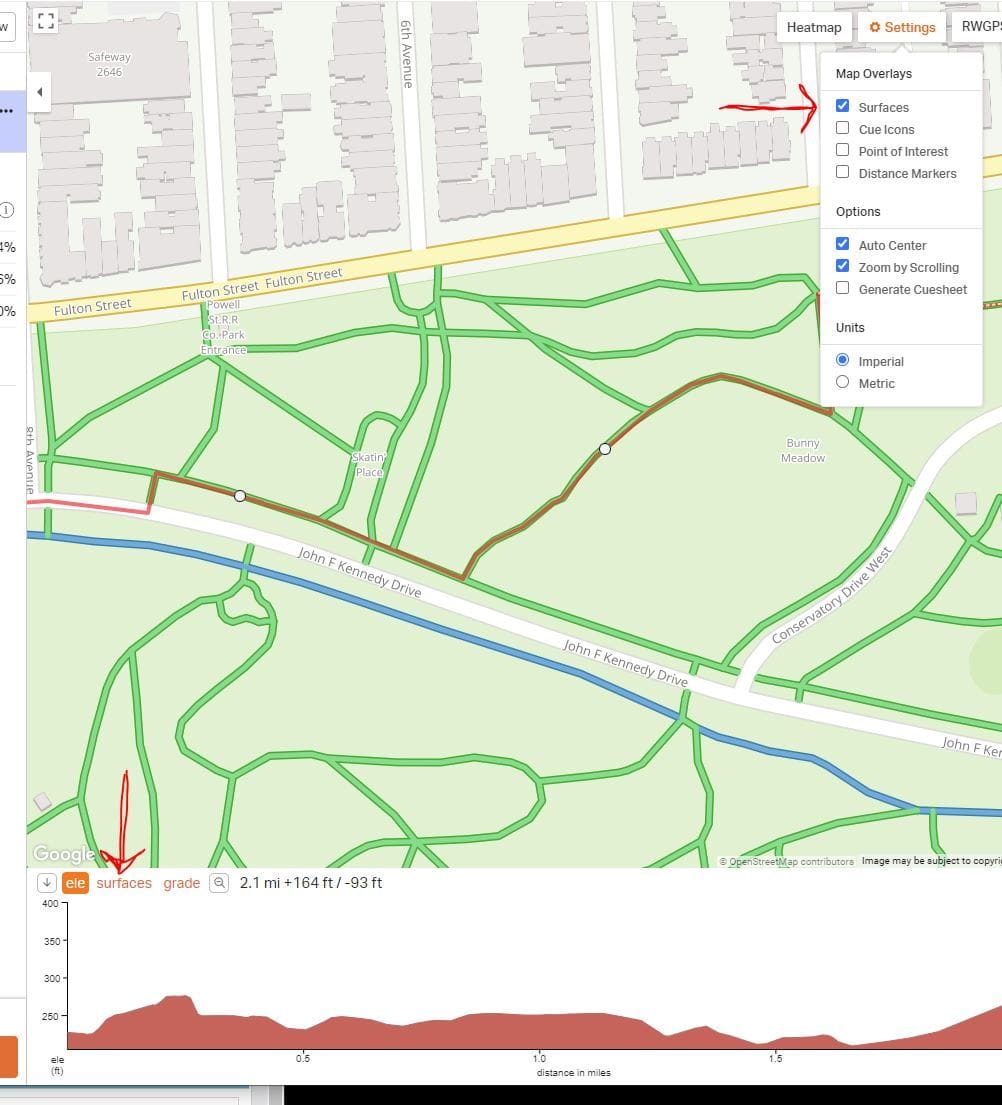
Just discovered today that RWGPS has implemented a new paved/unpaved modality.
It is automatically implemented in all maps - current & previous - with dotted lines.
It's lousy and inaccurate - and users received no notice beforehand.
The problem when you have any program which locks you in -
Is that it is difficult to transport out your files.
Because they are unique to that program.
But I am very disappointed in RWGPS.
Again.

Likes For jamawani:
08-18-21, 12:54 AM
#2
Senior Member
Join Date: May 2021
Location: San Francisco
Posts: 2,032
Bikes: addict, aethos, creo, vanmoof, sirrus, public ...
Mentioned: 2 Post(s)
Tagged: 0 Thread(s)
Quoted: 1273 Post(s)
Liked 1,384 Times
in
708 Posts
i noticed this as well, or rather noticed that it was not accurate initially. one obvious paved segment which was mis-categorized has now been fixed.
personally, i think it's a useful feature. i like to know when i'm going to be going off-road. also, it's VERY easily turned off. one click and it's gone from the map, another and it's gone from the elevation profile. it's also very clearly explained.
https://ridewithgps.com/help/surface-types
personally, i think it's a useful feature. i like to know when i'm going to be going off-road. also, it's VERY easily turned off. one click and it's gone from the map, another and it's gone from the elevation profile. it's also very clearly explained.
https://ridewithgps.com/help/surface-types
08-18-21, 12:57 AM
#3
Hooked on Touring
Thread Starter
For many people it may be nice.
But I have hundreds of routes filed - some for cycling organizations -
And I should not have to go back and "fix" all of them.
But I have hundreds of routes filed - some for cycling organizations -
And I should not have to go back and "fix" all of them.
08-18-21, 04:46 AM
#4
Senior Member
Join Date: Jan 2010
Posts: 39,217
Mentioned: 211 Post(s)
Tagged: 1 Thread(s)
Quoted: 18398 Post(s)
Liked 15,494 Times
in
7,317 Posts
I noticed the same thing two days ago. Wildly inaccurate. It showed paved that I have ridden on countless times as being unpaved. And I�m not talking rural roads.
I think it would be very useful if it were accurate, but how do I know if an unpaved road is being accurately presented as such if it inaccurately represents paved roads?
I think it would be very useful if it were accurate, but how do I know if an unpaved road is being accurately presented as such if it inaccurately represents paved roads?
Last edited by indyfabz; 08-18-21 at 04:50 AM.
08-18-21, 04:50 AM
#5
Senior Member
Join Date: Feb 2016
Location: SE Wisconsin
Posts: 1,851
Bikes: Lemond '01 Maillot Jaune, Lemond '02 Victoire, Lemond '03 Poprad, Lemond '03 Wayzata DB conv(Poprad), '79 AcerMex Windsor Carrera Professional(pur new), '88 GT Tequesta(pur new), '01 Bianchi Grizzly, 1993 Trek 970 DB conv, Trek 8900 DB conv
Mentioned: 12 Post(s)
Tagged: 0 Thread(s)
Quoted: 759 Post(s)
Likes: 0
Liked 809 Times
in
471 Posts
Exporting files from RWGPS is easy..in KML, GPX..etc standardized file formats. In those formats you can take them anywhere and use them. A bulk export would be nice, but exports are only one at a time as far as I know.
08-18-21, 04:56 AM
#6
Senior Member
Just did a group ride this past Saturday, downloaded the RWGPS .gpx file the ride leader posted and magically many roads had turned into dirt/gravel roads. Didn't really impact anything - these were all roads I know. I'm sure they will rectify the problem, not planning on using RWGPS to go any route planning until they do.
08-18-21, 07:01 AM
#7
Full Member
Join Date: Sep 2005
Location: Tulsa, OK
Posts: 451
Bikes: Co-Motion Americano Pinion P18; Co-Motion Americano Rohloff; Thorn Nomad MkII, Robert Beckman Skakkit (FOR SALE), Santana Tandem, ICE Adventure FS
Mentioned: 1 Post(s)
Tagged: 0 Thread(s)
Quoted: 169 Post(s)
Liked 64 Times
in
48 Posts
I don't seem to have it the new "feature" on all my routes
I have the free version. I looked at my settings and the "Surfaces" line is missing on some routes. Some of the newest created routes are non-Surfaces but almost all of the older ones are Surfaces. Go figure.
I have noticed also that if you use the "Map" map setting instead of the "RWGPS" map setting, it doesn't show the various surfaces. It looks like they have maybe tried to incorporate some of OSM Cycle map's look.
I have noticed also that if you use the "Map" map setting instead of the "RWGPS" map setting, it doesn't show the various surfaces. It looks like they have maybe tried to incorporate some of OSM Cycle map's look.
08-18-21, 07:14 AM
#8
Full Member
Join Date: Sep 2005
Location: Tulsa, OK
Posts: 451
Bikes: Co-Motion Americano Pinion P18; Co-Motion Americano Rohloff; Thorn Nomad MkII, Robert Beckman Skakkit (FOR SALE), Santana Tandem, ICE Adventure FS
Mentioned: 1 Post(s)
Tagged: 0 Thread(s)
Quoted: 169 Post(s)
Liked 64 Times
in
48 Posts
I just always cross reference Google's satellite view if in doubt. Except for areas of the country that use a more bluish/black gravel (like the Palouse area of Washington) I can almost always tell if it is gravel or pavement by either the color and/or if there are tell-tale signs, i.e. tar cracks, patterns in the road, a change of color from side streets, etc. Sure it would be nice if the maps were totally accurate but many times the underlying map data from the state government is wildly out of date.
08-18-21, 07:28 AM
#9
Senior Member
Join Date: Jan 2010
Posts: 39,217
Mentioned: 211 Post(s)
Tagged: 1 Thread(s)
Quoted: 18398 Post(s)
Liked 15,494 Times
in
7,317 Posts
I just always cross reference Google's satellite view if in doubt. Except for areas of the country that use a more bluish/black gravel (like the Palouse area of Washington) I can almost always tell if it is gravel or pavement by either the color and/or if there are tell-tale signs, i.e. tar cracks, patterns in the road, a change of color from side streets, etc. Sure it would be nice if the maps were totally accurate but many times the underlying map data from the state government is wildly out of date.
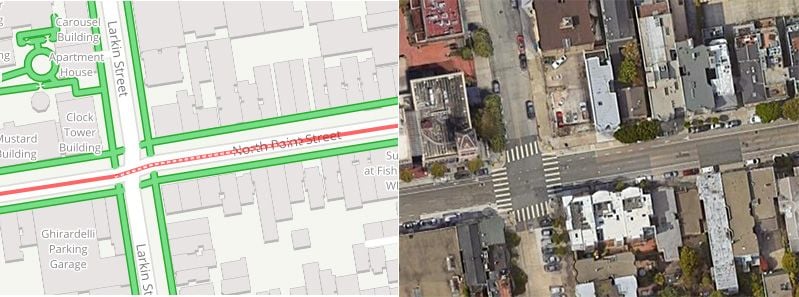
Here is day one of a tri[ I have planned for next month. Looks like it got most of it correct, but there is definitely one mistake. That first section shown as unpaved is 100%$ paved. I rode it three years ago.
[url=https://ridewithgps.com/routes/37033501]Dashboard � Ride with GPS
The map for Day 2 as at least one mistake. If you look at Street View where one road meets another, one of the road I will be riding looks unpaved. But if you switch to Satellite View you can clearly see that it's paved and even has a median stripe.
Last edited by indyfabz; 08-18-21 at 07:36 AM.
08-18-21, 07:44 AM
#10
Full Member
Join Date: Nov 2006
Posts: 235
Mentioned: 0 Post(s)
Tagged: 0 Thread(s)
Quoted: 48 Post(s)
Likes: 0
Liked 10 Times
in
10 Posts
I think this will be nice once the data is better. After finding this I've been updating all ore club routes. I've also been updating OSM for the roads I know the surface type of. See https://ridewithgps.com/help/edit-routing-data
08-18-21, 08:02 AM
#11
Full Member
Join Date: Sep 2005
Location: Tulsa, OK
Posts: 451
Bikes: Co-Motion Americano Pinion P18; Co-Motion Americano Rohloff; Thorn Nomad MkII, Robert Beckman Skakkit (FOR SALE), Santana Tandem, ICE Adventure FS
Mentioned: 1 Post(s)
Tagged: 0 Thread(s)
Quoted: 169 Post(s)
Liked 64 Times
in
48 Posts
Again, to me RWGPS is just using the crappy data that is out there, just like OSM Cycle does. Yes, I wish the data was accuate but if it is their sources that are bad. They are only showing what was given to them. If you don't like the new look ( I don't either), just unclick Surfaces and use the Map map method.
08-18-21, 09:16 AM
#12
Senior Member
Join Date: May 2021
Location: San Francisco
Posts: 2,032
Bikes: addict, aethos, creo, vanmoof, sirrus, public ...
Mentioned: 2 Post(s)
Tagged: 0 Thread(s)
Quoted: 1273 Post(s)
Liked 1,384 Times
in
708 Posts
i generally like RWGPS, except for a few very annoying bugs in the app that they haven�t been able to fix. their support was very responsive and professional but ultimately unhelpful. as a result i really only use it for route planning and visualizing upcoming elevation profiles while riding.
i don�t entirely trust their interpretation of roads and trails, so i do usually run a quick common sense check, or if i�m really not sure about an area, i�ll switch it to vehicular routing and make it show me definitively public paved roads.
i fail to understand how anything is lost with the new data - it�s not like it somehow prevents you from making the route, riding the route, etc. if you don�t trust or like the data just ignore it? does it actually damage the route data somehow? i looked at a dozen of my old routes on the phone app and they look exactly the same.
08-18-21, 11:55 AM
#13
Senior Member
Join Date: Jan 2010
Posts: 39,217
Mentioned: 211 Post(s)
Tagged: 1 Thread(s)
Quoted: 18398 Post(s)
Liked 15,494 Times
in
7,317 Posts
For one, I can see someone blindly trusting it and avoiding roads listed as unpaved which are, in fact, paved. (As we know, not every paved road is available to check out on Street View, and satellite imagery can be inconclusive.)
Interestingly, this afternoon I looked at another route I mapped out maybe a month or so ago. It now shows a random 0.3 mile stretch somewhere in the middle of of an 8 mil road segment as unpaved when it's not. I am curious to know how something like that happens. It's not like it was paved any time recently. I think I first traversed that road by car 45 years ago on the way to a week down the Jersey shore.
Interestingly, this afternoon I looked at another route I mapped out maybe a month or so ago. It now shows a random 0.3 mile stretch somewhere in the middle of of an 8 mil road segment as unpaved when it's not. I am curious to know how something like that happens. It's not like it was paved any time recently. I think I first traversed that road by car 45 years ago on the way to a week down the Jersey shore.
08-18-21, 01:24 PM
#14
Senior Member
Join Date: Dec 2010
Location: northern Deep South
Posts: 8,895
Bikes: Fuji Touring, Novara Randonee
Mentioned: 36 Post(s)
Tagged: 0 Thread(s)
Quoted: 2599 Post(s)
Liked 1,924 Times
in
1,208 Posts
Interestingly, this afternoon I looked at another route I mapped out maybe a month or so ago. It now shows a random 0.3 mile stretch somewhere in the middle of of an 8 mil road segment as unpaved when it's not. I am curious to know how something like that happens. It's not like it was paved any time recently.
 08-18-21, 01:26 PM
#15
Senior Member
Join Date: Jan 2010
Posts: 39,217
Mentioned: 211 Post(s)
Tagged: 1 Thread(s)
Quoted: 18398 Post(s)
Liked 15,494 Times
in
7,317 Posts
If only it were that. Just rode it a few weeks ago. Smooth as ever.
Now I am curious to check my other mapped routes.
Now I am curious to check my other mapped routes.
08-18-21, 02:14 PM
#16
Senior Member
Join Date: May 2021
Location: San Francisco
Posts: 2,032
Bikes: addict, aethos, creo, vanmoof, sirrus, public ...
Mentioned: 2 Post(s)
Tagged: 0 Thread(s)
Quoted: 1273 Post(s)
Liked 1,384 Times
in
708 Posts
whatever the data set is, it has some very random little glitches.
somehow this one partial segment of downtown city street is unpaved.
somehow this one partial segment of downtown city street is unpaved.
 08-18-21, 09:36 PM
#18
just another gosling
Join Date: Feb 2007
Location: Everett, WA
Posts: 19,527
Bikes: CoMo Speedster 2003, Trek 5200, CAAD 9, Fred 2004
Mentioned: 115 Post(s)
Tagged: 0 Thread(s)
Quoted: 3885 Post(s)
Liked 1,938 Times
in
1,383 Posts
Personally, I'm in awe at the excellence of RWGPS. I planned an entire 2 week tour in the Czech Republic with it, and the data was flawless, though it's always possible to be confused or taken aback when things don't look like you expected. I have hundreds of routes planned with it. If I want to check out if a road is gravel, I zoom in using Satellite view. That works well IME. I'll leave Surfaces turned off, no need for it. It's remarkable how well it can estimate my riding time for a new route.
__________________
Results matter
Results matter
08-19-21, 05:56 AM
#19
Senior Member
Join Date: Feb 2016
Location: SE Wisconsin
Posts: 1,851
Bikes: Lemond '01 Maillot Jaune, Lemond '02 Victoire, Lemond '03 Poprad, Lemond '03 Wayzata DB conv(Poprad), '79 AcerMex Windsor Carrera Professional(pur new), '88 GT Tequesta(pur new), '01 Bianchi Grizzly, 1993 Trek 970 DB conv, Trek 8900 DB conv
Mentioned: 12 Post(s)
Tagged: 0 Thread(s)
Quoted: 759 Post(s)
Likes: 0
Liked 809 Times
in
471 Posts
Well..if RWGPS is a such total disappointment..there are a dozen or two other applications you can use..for free..pick one and go. That'll shown'em..or develop your own system and do it the "right way".
I've used RWGPS for years and it's been excellent. So they try something new and it needs some tweaking..not unheard of in the R&D world. They'll figure it out. (It's good to know of the potential for errors..the edsel thing is a bit much..)
I've used RWGPS for years and it's been excellent. So they try something new and it needs some tweaking..not unheard of in the R&D world. They'll figure it out. (It's good to know of the potential for errors..the edsel thing is a bit much..)
Last edited by fishboat; 08-19-21 at 06:00 AM.
08-19-21, 08:25 AM
#20
Hooked on Touring
Thread Starter
I've been using RWGPS for years - and paying for it, too.
Yes, I can go elsewhere, but as a long-term paying customer, I expect better.
And, no, I shouldn't have to go out and make my own website.
That's what I have been paying for over the years.
At least, that's how the customer service model used to work back in 1958.
Acceptable loss has replaced customer retention -
When marketing discovered that it is cheaper to hustle up new customers that make good.
In addition, Ford couldn't change how your Edsel operated once you bought it back in 1958.
You know - like switching where the brake and gas pedals are.
Forgive me, but I though one of the aspirations of the digital age -
Was more choice, not less.
08-19-21, 09:02 AM
#21
Senior Member
Join Date: Feb 2016
Location: SE Wisconsin
Posts: 1,851
Bikes: Lemond '01 Maillot Jaune, Lemond '02 Victoire, Lemond '03 Poprad, Lemond '03 Wayzata DB conv(Poprad), '79 AcerMex Windsor Carrera Professional(pur new), '88 GT Tequesta(pur new), '01 Bianchi Grizzly, 1993 Trek 970 DB conv, Trek 8900 DB conv
Mentioned: 12 Post(s)
Tagged: 0 Thread(s)
Quoted: 759 Post(s)
Likes: 0
Liked 809 Times
in
471 Posts
Hey Fishboat - -
I've been using RWGPS for years - and paying for it, too.
Yes, I can go elsewhere, but as a long-term paying customer, I expect better.
And, no, I shouldn't have to go out and make my own website.
That's what I have been paying for over the years.
At least, that's how the customer service model used to work back in 1958.
Acceptable loss has replaced customer retention -
When marketing discovered that it is cheaper to hustle up new customers that make good.
In addition, Ford couldn't change how your Edsel operated once you bought it back in 1958.
You know - like switching where the brake and gas pedals are.
Forgive me, but I though one of the aspirations of the digital age -
Was more choice, not less.
I worked in RDE for 30+ years. Sometimes, sometimes a launch of something new has unintended consequences. The people in RDE are overwhelming trying to do something valuable and useful..you know..like you think you're doing. Their career isn't based on, "..let's see..how can we hose our customers today!"
Rather than giving them a proctology exam on day 2 of a launch, maybe report the issue to them and wait a bit to see how they handle it? If they ignore the issue a month or two down the line, well, then I suppose it's open season. If they lose business..it's their problem. If you need to go somewhere else..take a deep breath..you might learn something..like exporting files in a generic, industry standard, easily transferrable format.
That said..thanks for making us aware of the issue..though all of us users would have noticed this quite soon anyway. The rest of the (continued) drama..is just... needless drama.
..and the ignore list goes N+1
08-19-21, 09:56 AM
#22
Senior Member
Join Date: Jul 2007
Location: South shore, L.I., NY
Posts: 6,859
Bikes: Flyxii FR322, Cannondale Topstone, Miyata City Liner, Specialized Chisel, Specialized Epic Evo
Mentioned: 18 Post(s)
Tagged: 0 Thread(s)
Quoted: 3221 Post(s)
Liked 2,049 Times
in
1,171 Posts
Obviously there are issues with the underlaying data base. It does nothing to show where a paved road transitions to dirt on the section I just checked, Adirondacks, NY
 08-19-21, 11:30 AM
#23
Senior Member
Join Date: Sep 2007
Location: Far beyond the pale horizon.
Posts: 14,259
Mentioned: 31 Post(s)
Tagged: 0 Thread(s)
Quoted: 4245 Post(s)
Liked 1,349 Times
in
936 Posts
I think the idea that this feature "ruins" RWGPS is overwrought.
Moving off of RWGPS for this feature seems drastic. And what you move to might end up implementing it too.
It's easy enough to ignore it or turn it off.
I wonder what data they are using and whether they use OSM with the OSM maps.
Moving off of RWGPS for this feature seems drastic. And what you move to might end up implementing it too.
It's easy enough to ignore it or turn it off.
I wonder what data they are using and whether they use OSM with the OSM maps.
08-19-21, 12:05 PM
#24
Senior Member
Join Date: Jul 2007
Location: South shore, L.I., NY
Posts: 6,859
Bikes: Flyxii FR322, Cannondale Topstone, Miyata City Liner, Specialized Chisel, Specialized Epic Evo
Mentioned: 18 Post(s)
Tagged: 0 Thread(s)
Quoted: 3221 Post(s)
Liked 2,049 Times
in
1,171 Posts
Good question. I've only seen one online map data base that does an OK job at showing you what road is gravel/dirt and what's asphalt and that is Gaia GPS. Even there you need to consult the legend to verify road surface as they let you download a lot of different maps, Gaia Topo, USGS Topo, Nat'l Geo, etc... Gravel Maps does some good stuff, but it functions like TrailForks in that a road surface would be indicated as gravel IF somebody road and tracked a ride, then uploaded or traced a route.
08-19-21, 12:10 PM
#25
Senior Member
Join Date: Sep 2007
Location: Far beyond the pale horizon.
Posts: 14,259
Mentioned: 31 Post(s)
Tagged: 0 Thread(s)
Quoted: 4245 Post(s)
Liked 1,349 Times
in
936 Posts
Good question. I've only seen one online map data base that does an OK job at showing you what road is gravel/dirt and what's asphalt and that is Gaia GPS. Even there you need to consult the legend to verify road surface as they let you download a lot of different maps, Gaia Topo, USGS Topo, Nat'l Geo, etc... Gravel Maps does some good stuff, but it functions like TrailForks in that a road surface would be indicated as gravel IF somebody road and tracked a ride, then uploaded or traced a route.
At the present, I'd expect this info not to be great.
Focused things like trailforks is probably fine but it's also limited in coverage. Also, the data they have is access limited (unlike info in OSM).