


Highway 1 is closed along a big chunk of Big Sur, CA. What now?
 02-11-21, 07:51 AM
#1
Newbie
Thread Starter
Highway 1 is closed along a big chunk of Big Sur, CA. What now?
As some of you might be aware, a section of Highway 1 in Big Sur is closed. This throws a ratchet into my planned bike trip from San Francisco to Los Angeles. Can anyone recommend an alternative route from Santa Cruz to Morro Beach State Park? I have two days to get from the former to the latter and would like to bicycle no more than 90 miles per day. I am contemplating taking Route 101, but I'd prefer to take backgrounds, to avoid traffic, and perhaps enjoy better scenery. Any advice? My trip is scheduled for late March. Also, can anyone recommend a camping spot between these two locations?
 02-11-21, 08:27 AM
#2
Senior Member
Join Date: Dec 2010
Location: northern Deep South
Posts: 8,900
Bikes: Fuji Touring, Novara Randonee
Mentioned: 36 Post(s)
Tagged: 0 Thread(s)
Quoted: 2603 Post(s)
Liked 1,926 Times
in
1,209 Posts
Adventure Cycling has posted a (rather long) detour: PC04 Detour 2021 - A bike ride in Marina, CA (ridewithgps.com)
It's possible shorter detours will be possible as CalTrans clears some of the other, shorter slides on that stretch. Pity, as that stretch is one of the highlights of the ride.
It's possible shorter detours will be possible as CalTrans clears some of the other, shorter slides on that stretch. Pity, as that stretch is one of the highlights of the ride.
Likes For pdlamb:
02-11-21, 08:50 AM
#3

Sunshine

Join Date: Aug 2014
Location: Des Moines, IA
Posts: 16,608
Bikes: '18 class built steel roadbike, '19 Fairlight Secan, '88 Schwinn Premis , Black Mountain Cycles Monstercross V4, '89 Novara Trionfo
Mentioned: 123 Post(s)
Tagged: 0 Thread(s)
Quoted: 10954 Post(s)
Liked 7,482 Times
in
4,184 Posts
Down Hwy1 its 175mi from Santa Cruz to the park. Tough to hope for a detour around mountains to be less than 180mi.
Here is a nice 7700' climb over 200mi of secondary roads. Certainly will have some scenery compared to main highway riding. Its similar to the ACA route posted above.
Last edited by mstateglfr; 02-11-21 at 09:58 AM.
02-11-21, 09:22 AM
#8
Senior Member
Join Date: Jan 2010
Posts: 39,230
Mentioned: 211 Post(s)
Tagged: 1 Thread(s)
Quoted: 18409 Post(s)
Liked 15,520 Times
in
7,324 Posts
Down Hwy1 its 175mi from Santa Cruz to the park. Tough to hope for a detour around mountains to be less than 180mi.
Here is a nice 7700' climb over 200mi of secondary roads. Certainly will have some scenery compared to main highway riding. Its similar to the ACA route posted above.
Here is a nice 7700' climb over 200mi of secondary roads. Certainly will have some scenery compared to main highway riding. Its similar to the ACA route posted above.
02-11-21, 09:34 AM
#9
Senior Member
Join Date: Jul 2014
Location: socal
Posts: 4,261
Mentioned: 9 Post(s)
Tagged: 0 Thread(s)
Quoted: 880 Post(s)
Liked 817 Times
in
617 Posts
Might check Cycle World or Motorcyclist magazine (online only now). A couple of guys did it on motorcycles a couple of years ago when another section had been washed out.
02-11-21, 09:51 AM
#10
Newbie
Join Date: Jul 2020
Posts: 61
Mentioned: 0 Post(s)
Tagged: 0 Thread(s)
Quoted: 14 Post(s)
Likes: 0
Liked 37 Times
in
18 Posts
I would not consider 101 an option. I'm not even sure it's legal in some sections. The link above seems reasonable. However, since you'd be missing the most beautiful section of the ride I wouldn't do it until hwy 1 reopens. The other option would be to go north. The scenery is amazing.
Likes For Bosco13:
02-11-21, 09:59 AM
#11
Sunshine
Join Date: Aug 2014
Location: Des Moines, IA
Posts: 16,608
Bikes: '18 class built steel roadbike, '19 Fairlight Secan, '88 Schwinn Premis , Black Mountain Cycles Monstercross V4, '89 Novara Trionfo
Mentioned: 123 Post(s)
Tagged: 0 Thread(s)
Quoted: 10954 Post(s)
Liked 7,482 Times
in
4,184 Posts
Ha! Good point.
Its a screenshot of google maps.
edited to add- here is a quickly created GPS route link. https://ridewithgps.com/routes/35170622
At the mid point, so miles 90-110 or so, you ride thru Greenfield and King City. That may help for campground searches.
edited again- this is another option. fewer miles, but less coastal riding. https://ridewithgps.com/routes/35170659
You should sat view whatever route you choose/create as some of the area between Monterey and Morro is serious wilderness. You dont want google maps taking you down a hiking path that it thinks is a road.
Last edited by mstateglfr; 02-11-21 at 10:23 AM.
02-11-21, 10:42 AM
#12
I'm good to go!
Join Date: Jul 2017
Location: Mississippi
Posts: 14,984
Bikes: Tarmac Disc Comp Di2 - 2020
Mentioned: 51 Post(s)
Tagged: 0 Thread(s)
Quoted: 6191 Post(s)
Liked 4,806 Times
in
3,315 Posts
I'd postpone your ride and find something else till they get that stretch re-opened. The views are too good to miss. Perhaps you might go from Sausalito north on Hwy 1. That has excellent views too.
Likes For Iride01:
02-11-21, 11:58 AM
#14

Senior Member
Join Date: Sep 2014
Posts: 3,893
Mentioned: 20 Post(s)
Tagged: 0 Thread(s)
Quoted: 1062 Post(s)
Liked 665 Times
in
421 Posts
Given there will be virtually no cars, I'll bet that out-and-back rides on highway 1 will be popular this summer. I'd sure be tempted if I lived anywhere close.
Likes For Gresp15C:
02-11-21, 12:02 PM
#15
LR�P=HR
Join Date: Sep 2019
Location: SF Bay Area
Posts: 2,173
Bikes: 1981 Holdsworth Special, 1993 C-dale MT3000 & 1996 F700CAD3, 2018 Cervelo R3 & 2022 R5, JustGo Runt, Ridley Oval, Kickr Bike 8-)
Mentioned: 1 Post(s)
Tagged: 0 Thread(s)
Quoted: 865 Post(s)
Liked 1,201 Times
in
692 Posts
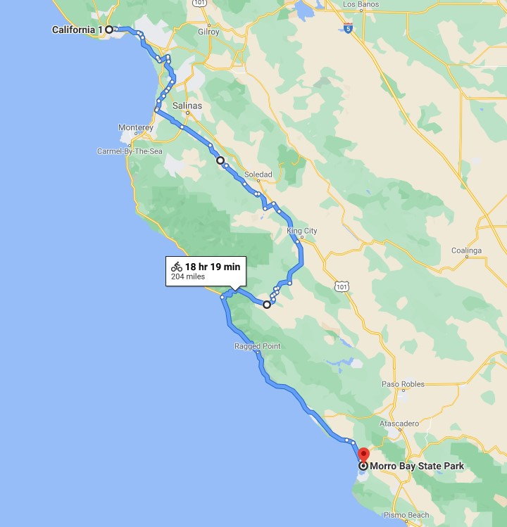
Map
Why does Google Maps tell you to go around (224miles) if you ask for directions by Car.
BUT tells you go go direct (25 miles) if you ask for directions by Bike ?
It it possible that the closure is only for vehicles?
Click "more options" to open the link, then try clicking bike/car in the top left corner
All the best
Barry
BUT tells you go go direct (25 miles) if you ask for directions by Bike ?
It it possible that the closure is only for vehicles?
Click "more options" to open the link, then try clicking bike/car in the top left corner
All the best
Barry
Last edited by Barry2; 02-11-21 at 01:37 PM.
02-11-21, 12:05 PM
#16
Sunshine
Join Date: Aug 2014
Location: Des Moines, IA
Posts: 16,608
Bikes: '18 class built steel roadbike, '19 Fairlight Secan, '88 Schwinn Premis , Black Mountain Cycles Monstercross V4, '89 Novara Trionfo
Mentioned: 123 Post(s)
Tagged: 0 Thread(s)
Quoted: 10954 Post(s)
Liked 7,482 Times
in
4,184 Posts
For sure- hope it helps get you started on nailing down a route that works. My parents moved out to Half Moon Bay CA when I went to college so all my visits 'home' were to a new place where I knew nobody. Each day I grabbed a car and drove all over central CA from Marin County east to wine country, down all thru the Bay Area, then down thru Santa Cruz and past Pebble to Big Sur. Each visit I would hit up a different section of central CA thru a few days of driving. Its a super cool area and I am really jealous you get to experience it at a bike's pace! Hopefully you can make a detour work out so that it isnt just a struggle-fest and you can enjoy the ride too.
02-11-21, 01:22 PM
#17
Senior Member
Join Date: May 2020
Posts: 490
Mentioned: 0 Post(s)
Tagged: 0 Thread(s)
Quoted: 252 Post(s)
Liked 67 Times
in
48 Posts
When the road is washed in places, that makes it impassable for most vehicles but with bike, you can walk it or shoulder it and make few hundred feet detour through the surrounding countryside to bypass the washed out section(s).
Problem might be, this being CA, you might be prevented doing that for various reasons. In Europe where I live and bike, there was a bridge under repair for a good part of the year and on my rides, I needed to cross that bridge and did so on several occasions (after work hours but even with some workers present, they would just look and let me go past them) until the construction took a more serious turn and it was not passable at all. But if that was not a bridge but a road, on bike or on foot you stand good chance bypassing the place.
Problem might be, this being CA, you might be prevented doing that for various reasons. In Europe where I live and bike, there was a bridge under repair for a good part of the year and on my rides, I needed to cross that bridge and did so on several occasions (after work hours but even with some workers present, they would just look and let me go past them) until the construction took a more serious turn and it was not passable at all. But if that was not a bridge but a road, on bike or on foot you stand good chance bypassing the place.
02-11-21, 02:37 PM
#18
Sunshine
Join Date: Aug 2014
Location: Des Moines, IA
Posts: 16,608
Bikes: '18 class built steel roadbike, '19 Fairlight Secan, '88 Schwinn Premis , Black Mountain Cycles Monstercross V4, '89 Novara Trionfo
Mentioned: 123 Post(s)
Tagged: 0 Thread(s)
Quoted: 10954 Post(s)
Liked 7,482 Times
in
4,184 Posts
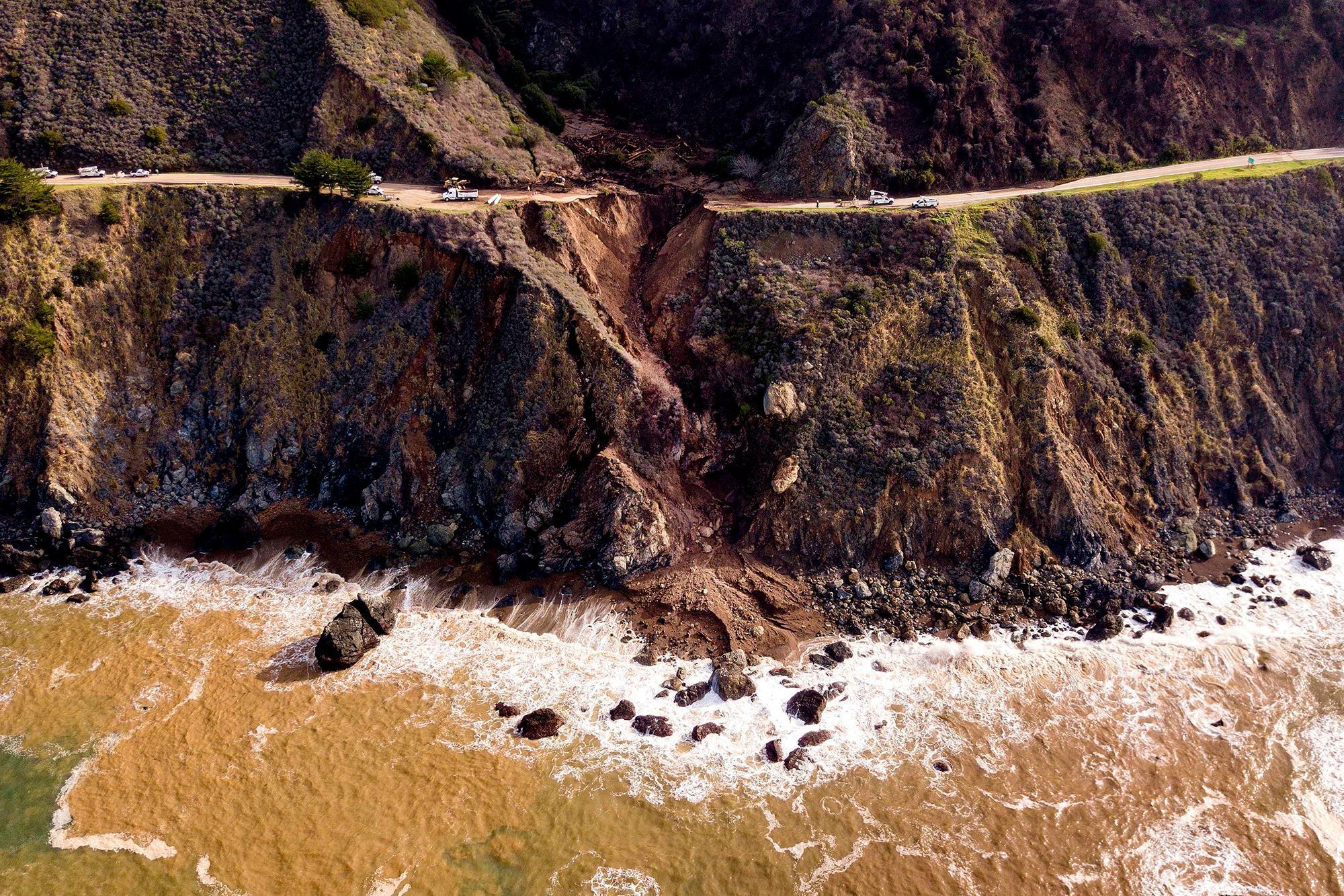
For reference, this is the issue.
I guess you can technically go around anything if you are willing to.

I guess you can technically go around anything if you are willing to.
Likes For mstateglfr:
02-11-21, 03:39 PM
#19
Senior Member
Join Date: Feb 2017
Location: Hollister, CA (not the surf town)
Posts: 1,737
Bikes: 2019 Specialized Roubaix Comp Di2, 2009 Roubaix, early 90's Giant Iguana
Mentioned: 8 Post(s)
Tagged: 0 Thread(s)
Quoted: 642 Post(s)
Liked 1,524 Times
in
550 Posts
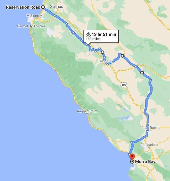
I live on the central coast and there are plenty of roads to take. I like the use of Reservation road off 1 to get over near the 101 corridor. Most of it has a good shoulder and not much traffic after you pass Hwy 68. Nacimiento-Ferguson Rd through Fort Hunter Ligget and over to the coast is an awesome road but last I heard it has closures. Might be ok by the time you take your trip but I would check regularly. This road also has some long steep sections and is very windy. The descent from the crest down to 1 on a loaded touring bike will test your brakes.
There are various backroads that sort of parallel 101 or you can go inland at King City and pick up 25 and the Peachtree/Indian Valley Rd. That will take you down to San Miguel or all the way to Paso Robles. The only caution here is that the roads you would be on between King City and San Miguel are pretty deserted and there are no services at all including no place to get water so you need to be prepared for that.
From Paso I would take 46 over to Old Creek Rd and down into Cayucos. From Cayucos, there is a bike trail that will take you to Morro Bay if you can find it. Markings are not great. You can also ride the shoulder of Hwy 1 but it is not much fun due to the high speed traffic.
March should be a great time to do this. Should still be very green inland instead of brown and shouldn't be hot. Not sure about 2 days of riding though. You will be facing a lot more climbing than you would just riding down 1. May be ok for you but a good idea to look at the routes in detail and consider the elevation/grade. Have fun and be safe.
Likes For Ogsarg:
02-11-21, 04:19 PM
#20
I'm good to go!
Join Date: Jul 2017
Location: Mississippi
Posts: 14,984
Bikes: Tarmac Disc Comp Di2 - 2020
Mentioned: 51 Post(s)
Tagged: 0 Thread(s)
Quoted: 6191 Post(s)
Liked 4,806 Times
in
3,315 Posts
Why does Google Maps tell you to go around (224miles) if you ask for directions by Car.
BUT tells you go go direct (25 miles) if you ask for directions by Bike ?
It it possible that the closure is only for vehicles?
LINK TO GOOGLE MAP
Click "more options" to open the link, then try clicking bike/car in the top left corner
All the best
Barry
BUT tells you go go direct (25 miles) if you ask for directions by Bike ?
It it possible that the closure is only for vehicles?
LINK TO GOOGLE MAP
Click "more options" to open the link, then try clicking bike/car in the top left corner
All the best
Barry
Likes For Iride01:
02-11-21, 04:34 PM
#21
Senior Member
Join Date: Dec 2010
Location: northern Deep South
Posts: 8,900
Bikes: Fuji Touring, Novara Randonee
Mentioned: 36 Post(s)
Tagged: 0 Thread(s)
Quoted: 2603 Post(s)
Liked 1,926 Times
in
1,209 Posts
The north side (on the left of the second picture) looks like CALTRANS might want to deposit a few multi-ton boulders down at the surf to prevent undercutting the road there...
Likes For pdlamb:
02-11-21, 10:02 PM
#22
Senior Member
Join Date: May 2020
Posts: 490
Mentioned: 0 Post(s)
Tagged: 0 Thread(s)
Quoted: 252 Post(s)
Liked 67 Times
in
48 Posts
Where I come from, we learned not to take authorities words as given. It is like the unbelieving biblical Thomas who needed to put his hand on Christ's wounds to believe, in the same way, it may be well worth to check what the situation really is...

Nice pics, thanks.
Last edited by vane171; 02-11-21 at 10:18 PM.
02-11-21, 11:28 PM
#24

Senior Member

Join Date: Jul 2006
Location: San Jose (Willow Glen) Ca
Posts: 9,842
Bikes: Kirk Custom JK Special, '84 Team Miyata,(dura ace old school) 80?? SR Semi-Pro 600 Arabesque
Mentioned: 106 Post(s)
Tagged: 0 Thread(s)
Quoted: 2337 Post(s)
Liked 2,820 Times
in
1,540 Posts
__________________
Life is too short not to ride the best bike you have, as much as you can
(looking for Torpado Super light frame/fork or for Raleigh International frame fork 58cm)
Life is too short not to ride the best bike you have, as much as you can
(looking for Torpado Super light frame/fork or for Raleigh International frame fork 58cm)
02-11-21, 11:29 PM
#25
Senior Member
Join Date: Jul 2006
Location: San Jose (Willow Glen) Ca
Posts: 9,842
Bikes: Kirk Custom JK Special, '84 Team Miyata,(dura ace old school) 80?? SR Semi-Pro 600 Arabesque
Mentioned: 106 Post(s)
Tagged: 0 Thread(s)
Quoted: 2337 Post(s)
Liked 2,820 Times
in
1,540 Posts
No way this will work steep cliffs etc
__________________
Life is too short not to ride the best bike you have, as much as you can
(looking for Torpado Super light frame/fork or for Raleigh International frame fork 58cm)
Life is too short not to ride the best bike you have, as much as you can
(looking for Torpado Super light frame/fork or for Raleigh International frame fork 58cm)