


Pittsburgh to Beaver
 08-18-22, 04:37 PM
#1

Hooked on Touring
Thread Starter
Pittsburgh to Beaver
Shout out to western Penna riders - I'm planning a ride back east.
Which side of the Ohio River is better to ride on from Station Square to Beaver?
There's not a great route - and both Hwy 51 (west side) and Hwy 65 (east side) are multilane and busy.
(The Panhandle Trail is significantly out of the way & the Lincoln Highway is hilly, busy, and narrow.)
It seems pretty good from Pittsburgh to Ambridge.
Hwy 51 has recently been rebuilt from Station Square to McKees Rocks.
(And I want to head into the Bottoms to see all the Ukrainian churches there.)
Then you can cross onto Neville Island and back to the west bank at Coraopolis.
Then take the Sewickley Bridge to the east bank and ride north on Beaver St.
Then Merchant St. in Ambridge to Old Economy.
North of Ambridge it gets tricky.
Despite having to use Hwy 65 in sections, I lean towards the east bank.
Hwy 51 north of the Aliquippa Bridge has almost no shoulder and higher speeds than Hwy 65.
It would be nice if you could access Woodlawn Ave. from the bridge. (And it was improved.)
Plus, the Ohio River trail here is more drawing board than reality, right?
(Not to mention that northbound and southbound riders have different issues with access and turns.)
With all the defunct factory sites and reduced need for large rail yards,
there should be plenty of space for through bike routes.
Perhaps by 2050??
Thanks for any suggestions. - Jama
 08-19-22, 05:59 AM
#2
Full Member
Join Date: Feb 2015
Location: Pittsburgh, PA
Posts: 400
Bikes: Schwinn, Nishiki, Santana, Trek, Rodriguez
Mentioned: 0 Post(s)
Tagged: 0 Thread(s)
Quoted: 189 Post(s)
Likes: 0
Liked 106 Times
in
69 Posts
I cannot give a first hand experience. I have only ridden a small part of 51 close to the Point a long time back, in the past it was very narly west of the Point. However, you are correct that portions have been recently rebuilt and it may be better now for bikes. If no else chimes in with first hand experience, I'd be happy to drive it and give shoulder info. No idea about 65, I think shoulders disappear. Bike Pittsburgh has been very active in recent years. Their map is the best source of information for Pittsburgh.
https://bikepgh.org/resources/maps-g...re/map-routes/
https://bikepgh.org/resources/maps-g...re/map-routes/
08-19-22, 08:05 AM
#3
Hooked on Touring
Thread Starter
Thanks, IPG -
Yes, BikePittsburgh is a great source.
Wouldn't it be nice if the busways were opened to bicycles?
Yes, BikePittsburgh is a great source.
Wouldn't it be nice if the busways were opened to bicycles?
08-19-22, 10:43 AM
#4
Senior Member
Join Date: Nov 2010
Location: Along the Rivers of Pittsburgh
Posts: 1,255
Bikes: 2011 Novara Forza Hybrid, 2005 Trek 820, 1989 Cannondale SR500 Black Lightning, 1975 Mundo Cycles Caloi Racer
Mentioned: 0 Post(s)
Tagged: 0 Thread(s)
Quoted: 258 Post(s)
Liked 291 Times
in
157 Posts
I don't bike in this area, so take this for what it's worth - I'm not trying to discourage you but only warn you. One of my aunts lived in Ambridge, another in Emsworth, and my B-I-L used to live in Beaver (I live northeast of Pittsburgh) so we drove Rt. 65 often. I can't recall ever seeing anyone on a bike on this route. Traffic runs a lot faster than the posted limit. Shoulders, to my recollection, are non-existent and the lanes are narrow in a few areas. Use extreme caution.
From a personal protection standpoint, be situationally aware in McKee's Rocks. Things that happen there make the news, and not in a good way. Having said that, my wife and I used stop and buy pierogis from the old ladies at one of the churches, but it's been awhile.
From a personal protection standpoint, be situationally aware in McKee's Rocks. Things that happen there make the news, and not in a good way. Having said that, my wife and I used stop and buy pierogis from the old ladies at one of the churches, but it's been awhile.
Last edited by Altair 4; 08-19-22 at 10:46 AM.
08-19-22, 08:56 PM
#5
Hooked on Touring
Thread Starter
Thanks Altair -
Yeah, I know that businesses in McKees Rocks are largely reduced to Payday Loans and recovery centers. And Ukrainian immigrants barely scraping by in the early 1900s gave to build those huge churches that now have, maybe, 25 people - all old - on Sundays. The historic fancy neighborhoods are still fancy, but the old working-class neighborhoods like The Rocks and Braddock are devastated.
Yeah, I know that businesses in McKees Rocks are largely reduced to Payday Loans and recovery centers. And Ukrainian immigrants barely scraping by in the early 1900s gave to build those huge churches that now have, maybe, 25 people - all old - on Sundays. The historic fancy neighborhoods are still fancy, but the old working-class neighborhoods like The Rocks and Braddock are devastated.
Last edited by jamawani; 08-19-22 at 09:23 PM.
08-21-22, 12:52 PM
#6
Partially Sane.
Join Date: Jan 2016
Location: Sunny Sacramento.
Posts: 3,559
Bikes: Soma Saga, pre-disc
Mentioned: 22 Post(s)
Tagged: 0 Thread(s)
Quoted: 972 Post(s)
Likes: 0
Liked 643 Times
in
468 Posts
It's funny, I was born in New Castle, not too far from Pittsburgh, but have no useful advice whatsoever, lol. 🙄😉 I left that area back around 1979 or 1980, when all the steel mills shut down. 😟
There's definitely good food to be had, we used to drive out into the country, once or twice a month, to the Italian butcher's farm. Us kids always got a sausage on a roll, while the adults did adult things. 😎
There's definitely good food to be had, we used to drive out into the country, once or twice a month, to the Italian butcher's farm. Us kids always got a sausage on a roll, while the adults did adult things. 😎
08-21-22, 05:42 PM
#7
Senior Member
Last year I arrived in Pgh on the Pittsburgh Spur of the Underground Railroad, an Adventure Cycling route. The approach sucked. I would call some bike shops and clubs in the area. I think there are some easy ways in, but they involve local knowledge, like which side of the bridge has a bike/pedestrian lane.
Good luck.
Good luck.
08-22-22, 09:08 AM
#8
Hooked on Touring
Thread Starter
Thanks, Pratt -
Yep. Hwy 51 - the ACA route and Penna Route A - looks like it sux.
Sections with no shoulders, with Jersey barriers or curbs or guardrails and traffic going 50+ mph.
Hwy 65 on the other side has city street alternatives, although not perfect, with less traffic and much slower speeds.
However, there are still a few sections where you must get on Hwy 65, too.
08-22-22, 11:57 AM
#9
Senior Member
Join Date: Nov 2010
Location: Along the Rivers of Pittsburgh
Posts: 1,255
Bikes: 2011 Novara Forza Hybrid, 2005 Trek 820, 1989 Cannondale SR500 Black Lightning, 1975 Mundo Cycles Caloi Racer
Mentioned: 0 Post(s)
Tagged: 0 Thread(s)
Quoted: 258 Post(s)
Liked 291 Times
in
157 Posts
Thanks Altair -
Yeah, I know that businesses in McKees Rocks are largely reduced to Payday Loans and recovery centers. And Ukrainian immigrants barely scraping by in the early 1900s gave to build those huge churches that now have, maybe, 25 people - all old - on Sundays. The historic fancy neighborhoods are still fancy, but the old working-class neighborhoods like The Rocks and Braddock are devastated.
Yeah, I know that businesses in McKees Rocks are largely reduced to Payday Loans and recovery centers. And Ukrainian immigrants barely scraping by in the early 1900s gave to build those huge churches that now have, maybe, 25 people - all old - on Sundays. The historic fancy neighborhoods are still fancy, but the old working-class neighborhoods like The Rocks and Braddock are devastated.
So many of the working class houses were pretty insubstantial to begin with - wood frame, cheap "insul-brick" siding. A drive through the borough now will reveal many blocks that have been razed and are just green fields. There are some good signs of life - some brew pubs, some small businesses, but it's a long way to come back from the rock bottom that the town hit.
08-24-22, 12:27 AM
#10
Partially Sane.
Join Date: Jan 2016
Location: Sunny Sacramento.
Posts: 3,559
Bikes: Soma Saga, pre-disc
Mentioned: 22 Post(s)
Tagged: 0 Thread(s)
Quoted: 972 Post(s)
Likes: 0
Liked 643 Times
in
468 Posts
That was a bad bottom, alright, for the whole Rust Belt. I finished high school over in McDonald, Ohio, which is basically a suburb of Youngstown, Ohio. There was a U.S.Steel plant there, where my step-dad worked, and I probably would have got a job there, but they closed the mills, the same year I graduated, 1979. ☹️
I've gone back a few times, to visit family & friends, and saw some of that drug mess over the years. Trumbull County had the worst death rate in the country, for awhile at least. Sad.
I've gone back a few times, to visit family & friends, and saw some of that drug mess over the years. Trumbull County had the worst death rate in the country, for awhile at least. Sad.
08-24-22, 02:20 PM
#11
Senior Member
Thanks, Pratt -
Yep. Hwy 51 - the ACA route and Penna Route A - looks like it sux.
Sections with no shoulders, with Jersey barriers or curbs or guardrails and traffic going 50+ mph.
Hwy 65 on the other side has city street alternatives, although not perfect, with less traffic and much slower speeds.
However, there are still a few sections where you must get on Hwy 65, too.
Yep. Hwy 51 - the ACA route and Penna Route A - looks like it sux.
Sections with no shoulders, with Jersey barriers or curbs or guardrails and traffic going 50+ mph.
Hwy 65 on the other side has city street alternatives, although not perfect, with less traffic and much slower speeds.
However, there are still a few sections where you must get on Hwy 65, too.
08-24-22, 06:14 PM
#12
Senior Member
Join Date: Jan 2010
Posts: 39,229
Mentioned: 211 Post(s)
Tagged: 1 Thread(s)
Quoted: 18409 Post(s)
Liked 15,518 Times
in
7,324 Posts
That was a bad bottom, alright, for the whole Rust Belt. I finished high school over in McDonald, Ohio, which is basically a suburb of Youngstown, Ohio. There was a U.S.Steel plant there, where my step-dad worked, and I probably would have got a job there, but they closed the mills, the same year I graduated, 1979. ☹️
I've gone back a few times, to visit family & friends, and saw some of that drug mess over the years. Trumbull County had the worst death rate in the country, for awhile at least. Sad.
I've gone back a few times, to visit family & friends, and saw some of that drug mess over the years. Trumbull County had the worst death rate in the country, for awhile at least. Sad.
08-24-22, 08:08 PM
#13

don't try this at home.

Join Date: Jan 2006
Location: N. KY
Posts: 5,936
Mentioned: 10 Post(s)
Tagged: 0 Thread(s)
Quoted: 973 Post(s)
Liked 511 Times
in
351 Posts
I use the Strava Heatmap for scouting routes where I don't know the roads. It's based on 12 months of strava ride recordings (700 million miles in the US last year, I think!).
White hot=most popular, dim red=least popular. Gray=essentially no riders there.
Just because a road is white hot doesn't mean it's always a nice road to ride, it might be the only reasonable way to go near there.
I notice dim red roads and try to avoid those where there's nearby yellow or white roads. Cyclists are avoiding it.
Pittsburgh to Beaver PA area. Panning or zooming the map changes the URL to match the view: https://www.strava.com/heatmap#11.51...57881/hot/ride. You need a free Strava login to zoom in on this map.
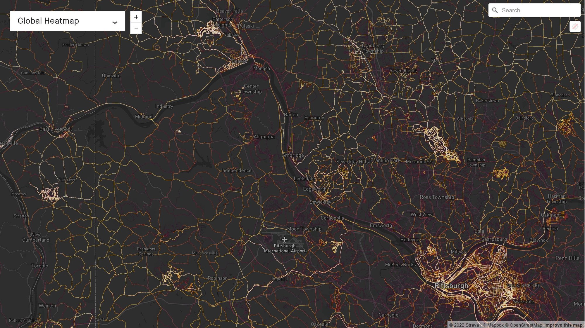
When I zoom in, it recolors the red...white range based on local ridership, since rural areas have way less mileage than cities.
Zoomed:

White hot=most popular, dim red=least popular. Gray=essentially no riders there.
Just because a road is white hot doesn't mean it's always a nice road to ride, it might be the only reasonable way to go near there.
I notice dim red roads and try to avoid those where there's nearby yellow or white roads. Cyclists are avoiding it.
Pittsburgh to Beaver PA area. Panning or zooming the map changes the URL to match the view: https://www.strava.com/heatmap#11.51...57881/hot/ride. You need a free Strava login to zoom in on this map.
When I zoom in, it recolors the red...white range based on local ridership, since rural areas have way less mileage than cities.
Zoomed:
Likes For rm -rf:
08-25-22, 04:34 AM
#14
Hooked on Touring
Thread Starter
I am cautious with Strava data, espcially in regards to touring.
Strava users are skewed to a younger, male, white, road bike demographic.
Note, also, the high concentration of riding in North Park, Brady's Run Park, and Hillman S.P.
(Even Tomlinson Run S.P. in the panhandle of West Virginia - which seems odd.)
Neville Island does stand out because of the better roads and lower traffic.
08-25-22, 08:49 AM
#15
Senior Member
Join Date: Dec 2010
Location: northern Deep South
Posts: 8,895
Bikes: Fuji Touring, Novara Randonee
Mentioned: 36 Post(s)
Tagged: 0 Thread(s)
Quoted: 2601 Post(s)
Liked 1,925 Times
in
1,208 Posts
Another caveat on heat maps is that recurring club rides or once-a-year events can skew the data, particularly in rural areas. I suspect you could look at this year's RAGBRAI route and, based on the color scheme, figure that's a great place to ride a bike. The fact that the roads were swamped and most locals tried to avoid driving those roads will be lost. I can pick out the club rides in my area pretty easily. The fact that those occur at 8:00 a.m. Saturday morning or after 6:00 p.m. on weeknights? Strava doesn't show that, and you could get into some uncomfortable traffic if you don't know that subtlety.
08-25-22, 09:10 AM
#16
bicycle tourist
Here is how I use the Strava heat map data when I am touring...
- The primary case for me is entering/exiting a larger and unfamiliar urban area. I've found that often there is a "doughnut" around an urban core where I need extra caution. In the city center, often the speeds are low (or they are clear expressways) and while traffic is dense there are often multiple roads to adjust. Far enough from the urban core, densities and traffic volumes can be less.
- In rural areas, I am more likely to consult a state bicycle map that shows me traffic counts and rough shoulders. I also am more likely to consult with state DOT to look for construction projects because that can really reconfigure some of these routes. Rural areas can also be a bit different in different parts of the country. In western or less populated states, there may be fewer road choices and often for a extended trip I'll look for a major US highway. In more populated areas, there can be more roads even in rural areas.
I think it is a useful tool in the tool box though like anything it can be overdone if that is only thing you use.
08-25-22, 09:30 AM
#17
Hooked on Touring
Thread Starter
That applies to Pittsburgh and many other metro areas.
In the city itself, there are bike trails, bike lanes, and residential streets.
In the country, there are farm roads - often paved back east.
But it's the suburbs - esp. the more distant ones that are challenging.
Also, because older urban planning involved interconnected streets.
Now, few new housing deveelopments are connected.
Just one or two entrances off Old Lincoln Highway - which cannot handle all the extra traffic.
For the past 80 years, urban design has been 99.9% car-oriented.
It's gotta change.
Likes For jamawani:
08-25-22, 10:11 AM
#18
Full Member
Join Date: Feb 2015
Location: Pittsburgh, PA
Posts: 400
Bikes: Schwinn, Nishiki, Santana, Trek, Rodriguez
Mentioned: 0 Post(s)
Tagged: 0 Thread(s)
Quoted: 189 Post(s)
Likes: 0
Liked 106 Times
in
69 Posts
I was at a town meeting Tuesday on how to reconfigure the road around the fallen fern hollow bridge to be bike/pedestrian friendly. 50 people present, 150 on zoom, the mayor was present and listening. It may be slow, but change is happening. Pittsburgh is much better than 30 years back, but in comparison to bike-friendly Seattle, still has a ways to go.
