


Huge Discrepancy in Elevation Gain between Wahoo and Strava iOS Apps
 12-16-21, 01:23 AM
#26
Obsessed with Eddington

Join Date: Jun 2013
Location: Brussels (BE) 🇧🇪
Posts: 1,330
Bikes: '16 Spesh Diverge, '14 Spesh Fatboy, '18 Spesh Epic, '18 Spesh SL6, '21 Spesh SL7, '21 Spesh Diverge...and maybe n+1?
Mentioned: 2 Post(s)
Tagged: 0 Thread(s)
Quoted: 532 Post(s)
Liked 621 Times
in
368 Posts
You need to caveat this. They are only �crap� when the barometric altimeter is exposed to rapid changes in ambient air pressure. When the atmosphere is stable a properly calibrated barometric altimeter is far superior to GPS derived map datums, which are most accurate when the elevation changes are minor (useless in mountains). The Strava (or any app�s) evaluation data is a poor approximation of actual elevation changes, it is only superior to barometric data when the atmosphere is unstable or there is no barometric data.
 12-16-21, 01:31 AM
#27
Obsessed with Eddington
Join Date: Jun 2013
Location: Brussels (BE) 🇧🇪
Posts: 1,330
Bikes: '16 Spesh Diverge, '14 Spesh Fatboy, '18 Spesh Epic, '18 Spesh SL6, '21 Spesh SL7, '21 Spesh Diverge...and maybe n+1?
Mentioned: 2 Post(s)
Tagged: 0 Thread(s)
Quoted: 532 Post(s)
Liked 621 Times
in
368 Posts
An estimate may or may not be accurate, but it will definitely give you an approximation. In my experience Strava elevation data, when I have compared it to actually recorded elevation data, suffers from some accuracy problems depending on where you are in the world, and which map datum they are drawing from in that location. For the most part, the Strava elevation data is decent in most of the US and Western Europe.
12-16-21, 09:15 AM
#28
Senior Member
Join Date: Aug 2019
Location: Qu�bec, Canada
Posts: 2,108
Bikes: SL8 Pro, TCR beater
Mentioned: 6 Post(s)
Tagged: 0 Thread(s)
Quoted: 981 Post(s)
Liked 583 Times
in
438 Posts
2 measures = 2 results. I am guessing one of them is smarter than the other.
I always use Strava's, because numbers are higher (of course!).
I always use Strava's, because numbers are higher (of course!).
Last edited by eduskator; 12-16-21 at 09:18 AM.
12-16-21, 11:25 AM
#29
Senior Member
Join Date: Mar 2010
Location: Seattle, WA
Posts: 23,208
Mentioned: 89 Post(s)
Tagged: 0 Thread(s)
Quoted: 18883 Post(s)
Liked 10,646 Times
in
6,054 Posts
From GPS. The file you record just has a field for elevation, it doesn't care how accurate it is. The file header identifies the device that recorded it, Strava keeps your elevation numbers if it thinks you had a barometer and it ignores them and uses its DEM instead of it thinks you didn't, because GPS elevation data is universally considered bad.
Likes For Seattle Forrest:
12-16-21, 11:47 AM
#30
Obsessed with Eddington
Join Date: Jun 2013
Location: Brussels (BE) 🇧🇪
Posts: 1,330
Bikes: '16 Spesh Diverge, '14 Spesh Fatboy, '18 Spesh Epic, '18 Spesh SL6, '21 Spesh SL7, '21 Spesh Diverge...and maybe n+1?
Mentioned: 2 Post(s)
Tagged: 0 Thread(s)
Quoted: 532 Post(s)
Liked 621 Times
in
368 Posts
From GPS. The file you record just has a field for elevation, it doesn't care how accurate it is. The file header identifies the device that recorded it, Strava keeps your elevation numbers if it thinks you had a barometer and it ignores them and uses its DEM instead of it thinks you didn't, because GPS elevation data is universally considered bad.
It's probably a distinction without difference, but the elevation is not being recorded or determined directly from the GPS. It is instead being derived by using your 2-dimensional (N and E) GPS positional data to derive your elevation by joining it to the DEM.
12-16-21, 05:20 PM
#31
Method to My Madness
Thread Starter
Join Date: Nov 2020
Location: Orange County, California
Posts: 3,641
Bikes: Trek FX 2, Cannondale Synapse, Cannondale CAAD4, Santa Cruz Stigmata GRX
Mentioned: 4 Post(s)
Tagged: 0 Thread(s)
Quoted: 1939 Post(s)
Liked 1,463 Times
in
1,012 Posts
I do not have a barometer or bike computer, but would the barometer reading remain accurate if there are localized temperature changes? For example, when riding from the bike lane in the sun onto a bike trail shaded by trees?
12-16-21, 05:49 PM
#32

I'm good to go!
Join Date: Jul 2017
Location: Mississippi
Posts: 14,953
Bikes: Tarmac Disc Comp Di2 - 2020
Mentioned: 51 Post(s)
Tagged: 0 Thread(s)
Quoted: 6178 Post(s)
Liked 4,795 Times
in
3,307 Posts
Reasonably well yes. But to your expectations, probably not.
Likes For Iride01:
12-16-21, 10:32 PM
#33
Senior Member
Join Date: Jul 2015
Location: reno, nv
Posts: 2,298
Bikes: yes, i have one
Mentioned: 2 Post(s)
Tagged: 0 Thread(s)
Quoted: 1136 Post(s)
Liked 1,179 Times
in
686 Posts
That’s what I thought you meant. Once point of clarification, without a barometric altimeter, there is no elevation data in the elevation field, and Strava fills it in from a pre-determined DEM, as you’ve pointed out, in the .fit file they generate when your activity is uploaded.
It's probably a distinction without difference, but the elevation is not being recorded or determined directly from the GPS. It is instead being derived by using your 2-dimensional (N and E) GPS positional data to derive your elevation by joining it to the DEM.
It's probably a distinction without difference, but the elevation is not being recorded or determined directly from the GPS. It is instead being derived by using your 2-dimensional (N and E) GPS positional data to derive your elevation by joining it to the DEM.
i should be clear that my phone does not have a barometric altimeter.
Last edited by spelger; 12-16-21 at 10:33 PM. Reason: added teh bit about barometric altimeter.
Likes For spelger:
12-16-21, 11:26 PM
#34
Senior Member
Join Date: Mar 2010
Location: Seattle, WA
Posts: 23,208
Mentioned: 89 Post(s)
Tagged: 0 Thread(s)
Quoted: 18883 Post(s)
Liked 10,646 Times
in
6,054 Posts
That�s what I thought you meant. Once point of clarification, without a barometric altimeter, there is no elevation data in the elevation field, and Strava fills it in from a pre-determined DEM, as you�ve pointed out, in the .fit file they generate when your activity is uploaded.
It's probably a distinction without difference, but the elevation is not being recorded or determined directly from the GPS. It is instead being derived by using your 2-dimensional (N and E) GPS positional data to derive your elevation by joining it to the DEM.
It's probably a distinction without difference, but the elevation is not being recorded or determined directly from the GPS. It is instead being derived by using your 2-dimensional (N and E) GPS positional data to derive your elevation by joining it to the DEM.
Likes For Seattle Forrest:
12-16-21, 11:38 PM
#35
Senior Member
Join Date: Mar 2010
Location: Seattle, WA
Posts: 23,208
Mentioned: 89 Post(s)
Tagged: 0 Thread(s)
Quoted: 18883 Post(s)
Liked 10,646 Times
in
6,054 Posts
I thought GPS can be used to determine elevation reasonably well if the GPS is locked onto four or more GPS satellites?
I do not have a barometer or bike computer, but would the barometer reading remain accurate if there are localized temperature changes? For example, when riding from the bike lane in the sun onto a bike trail shaded by trees?
I do not have a barometer or bike computer, but would the barometer reading remain accurate if there are localized temperature changes? For example, when riding from the bike lane in the sun onto a bike trail shaded by trees?
To your question the temperature like in the sun or shade shouldn't have much effect. Differences in barometric pressure can be from other things than elevation though. Weather especially storms, fronts, riding from one valley over a mountain pass into another valley sometimes, things like that.
Likes For Seattle Forrest:
12-17-21, 12:32 AM
#36
Obsessed with Eddington
Join Date: Jun 2013
Location: Brussels (BE) 🇧🇪
Posts: 1,330
Bikes: '16 Spesh Diverge, '14 Spesh Fatboy, '18 Spesh Epic, '18 Spesh SL6, '21 Spesh SL7, '21 Spesh Diverge...and maybe n+1?
Mentioned: 2 Post(s)
Tagged: 0 Thread(s)
Quoted: 532 Post(s)
Liked 621 Times
in
368 Posts
GPS is pretty good for lat/long but less accurate for elevation. But GPS can be used for elevation. I've been using a Garmin watch for years, I have a screen set up (for hiking) showing me the GPS altitude and the barometric altitude, along with some other things. You can record a gpx file on a device without a barometer or DEM and still get elevation data, it's just noisy.
I thought GPS can be used to determine elevation reasonably well if the GPS is locked onto four or more GPS satellites?
I do not have a barometer or bike computer, but would the barometer reading remain accurate if there are localized temperature changes? For example, when riding from the bike lane in the sun onto a bike trail shaded by trees?
I do not have a barometer or bike computer, but would the barometer reading remain accurate if there are localized temperature changes? For example, when riding from the bike lane in the sun onto a bike trail shaded by trees?
The formula for turning air pressure into elevation takes temperature as an input. That's why the watches have a thermometer, it's useless otherwise because your body temp throws it off but it measures temp at the barometer. Got to be why most of the Edge computers have thermometers too.
To your question the temperature like in the sun or shade shouldn't have much effect. Differences in barometric pressure can be from other things than elevation though. Weather especially storms, fronts, riding from one valley over a mountain pass into another valley sometimes, things like that.
To your question the temperature like in the sun or shade shouldn't have much effect. Differences in barometric pressure can be from other things than elevation though. Weather especially storms, fronts, riding from one valley over a mountain pass into another valley sometimes, things like that.
 12-17-21, 05:49 PM
#38
Full Member
Likes For kcjc:
12-17-21, 08:21 PM
#39
Senior Member
Join Date: Mar 2010
Location: Seattle, WA
Posts: 23,208
Mentioned: 89 Post(s)
Tagged: 0 Thread(s)
Quoted: 18883 Post(s)
Liked 10,646 Times
in
6,054 Posts
12-18-21, 12:11 PM
#40
Sr Member on Sr bikes

Does the elevation graphic show an anomaly somewhere along your route? I encounter them every once in a while on my Strava workouts. For example, in the below screenshot of a Strava walk/jog I did along the beach at Punta Cana, DR in 2018 you�ll notice at � mile and 3� miles on the elevation graphic (below the map) my elevation plunges from sea level to 1000 feet below sea level in a really short distance. When I finished that activity and saw that it recorded that much elevation change, I thought WTF? I didn�t leave the beach. I can assure you that I didn�t fall into an abyss. We vacationed there in 2019 also and it did the same thing in the same spots. (I should have checked it with another app, like MMR, but I didn�t.) I can�t explain it, and I�ve seen weird things like this in other places too. I don�t know if it�s a flaw in the Strava elevation function, the GPS system, or some sort of natural phenomenon. � Dan

12-18-21, 01:15 PM
#41
Full Member

Join Date: Sep 2019
Posts: 393
Mentioned: 18 Post(s)
Tagged: 0 Thread(s)
Quoted: 170 Post(s)
Liked 264 Times
in
146 Posts
Around Seattle, the Wahoo app on my smartypants barometer-enhanced iPhony never fails to yield much higher elevation data. 10k climbing w/ Wahoo app => Strava => becomes 5-6k. Others have suggested an actual Wahoo device would be more accurate than the app, but it doesn't matter to me either way so I'm cool with Strava's conservative (?) estimations.
12-18-21, 02:18 PM
#42
Method to My Madness
Thread Starter
Join Date: Nov 2020
Location: Orange County, California
Posts: 3,641
Bikes: Trek FX 2, Cannondale Synapse, Cannondale CAAD4, Santa Cruz Stigmata GRX
Mentioned: 4 Post(s)
Tagged: 0 Thread(s)
Quoted: 1939 Post(s)
Liked 1,463 Times
in
1,012 Posts
Around Seattle, the Wahoo app on my smartypants barometer-enhanced iPhony never fails to yield much higher elevation data. 10k climbing w/ Wahoo app => Strava => becomes 5-6k. Others have suggested an actual Wahoo device would be more accurate than the app, but it doesn't matter to me either way so I'm cool with Strava's conservative (?) estimations.
12-18-21, 05:59 PM
#44
Method to My Madness
Thread Starter
Join Date: Nov 2020
Location: Orange County, California
Posts: 3,641
Bikes: Trek FX 2, Cannondale Synapse, Cannondale CAAD4, Santa Cruz Stigmata GRX
Mentioned: 4 Post(s)
Tagged: 0 Thread(s)
Quoted: 1939 Post(s)
Liked 1,463 Times
in
1,012 Posts
12-19-21, 12:51 AM
#45
Senior Member
Join Date: Mar 2010
Location: Seattle, WA
Posts: 23,208
Mentioned: 89 Post(s)
Tagged: 0 Thread(s)
Quoted: 18883 Post(s)
Liked 10,646 Times
in
6,054 Posts
What does the device name say in the files it records?
Likes For Seattle Forrest:
12-19-21, 03:50 PM
#46
Senior Member
Join Date: Jul 2015
Location: reno, nv
Posts: 2,298
Bikes: yes, i have one
Mentioned: 2 Post(s)
Tagged: 0 Thread(s)
Quoted: 1136 Post(s)
Liked 1,179 Times
in
686 Posts
They actually put them in on the theory that having a barometer will get you a GPS lock faster. Knowing your approximate elevation means being able to throw out a lot of potential but wrong solutions while you're acquiring satellites.
What does the device name say in the files it records?
What does the device name say in the files it records?
Likes For spelger:
12-19-21, 11:20 PM
#47
Method to My Madness
Thread Starter
Join Date: Nov 2020
Location: Orange County, California
Posts: 3,641
Bikes: Trek FX 2, Cannondale Synapse, Cannondale CAAD4, Santa Cruz Stigmata GRX
Mentioned: 4 Post(s)
Tagged: 0 Thread(s)
Quoted: 1939 Post(s)
Liked 1,463 Times
in
1,012 Posts
I don't know how to get a .gpx file. The Wahoo iOS app can export a .fit file but I am still looking for a viewer or preferably a converter to Excel; can anyone please recommend such an app (preferably PC)?
12-19-21, 11:42 PM
#48
Junior Member
Join Date: Oct 2006
Posts: 172
Mentioned: 1 Post(s)
Tagged: 0 Thread(s)
Quoted: 83 Post(s)
Liked 157 Times
in
55 Posts
I used both Strava and Wahoo apps on the same iPhone X while hiking. Wahoo gave unrealistically high numbers for climbing compared to Strava. These days I use Garmin Forerunner 935 watch - it is quite close to Strava numbers. So my take is that Wahoo lies regarding climbing numbers, I do not use it anymore.
12-20-21, 01:11 AM
#49
Kamen Rider

Join Date: Aug 2017
Location: KL, MY
Posts: 1,071
Bikes: Fuji Transonic Elite, Marechal Soul Ultimate, Dahon Dash Altena
Mentioned: 11 Post(s)
Tagged: 0 Thread(s)
Quoted: 351 Post(s)
Liked 277 Times
in
164 Posts
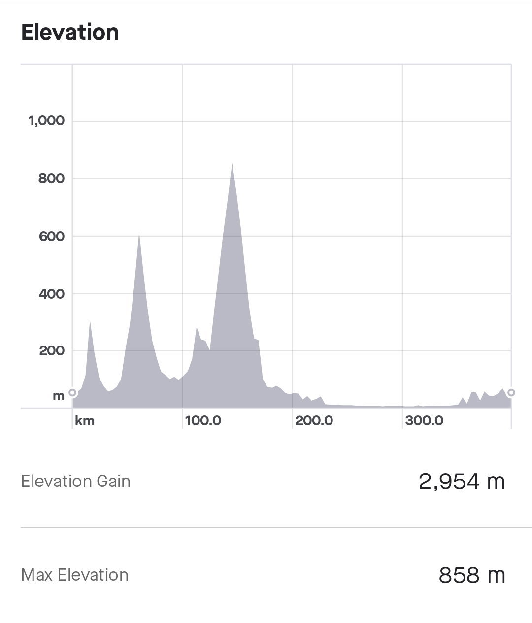
If you want to see what a "huge" discrepancy looks like, this is the elevation profile recorded by my Garmin Edge 1030 - which has a barometric altimeter - during a heavy monsoon rain at the weekend:

compared to the Strava-corrected elevation profile, which is a whole lot more representative of what the ride actually looked like:
compared to the Strava-corrected elevation profile, which is a whole lot more representative of what the ride actually looked like:
12-20-21, 01:39 AM
#50
Senior Member
Join Date: Mar 2010
Location: Seattle, WA
Posts: 23,208
Mentioned: 89 Post(s)
Tagged: 0 Thread(s)
Quoted: 18883 Post(s)
Liked 10,646 Times
in
6,054 Posts
Golden Cheetah will show you the raw data in a grid and let you copy it in a way that Excel can understand. Might have an export, I've never tried.
Likes For Seattle Forrest: