


Comments/suggestions wrt Banff > Yellowstone > Twin Falls:Pendleton > Seattle
 03-23-22, 08:17 AM
#1
Senior Member
Thread Starter
Join Date: Sep 2015
Location: QC Canada
Posts: 1,962
Bikes: Custom built LHT & Troll
Mentioned: 12 Post(s)
Tagged: 0 Thread(s)
Quoted: 838 Post(s)
Liked 149 Times
in
106 Posts
Comments/suggestions wrt Banff > Yellowstone > Twin Falls:Pendleton > Seattle
Just about to confirm plane tickets for this summer. My wife, daughter (11yo) and myself are budgeting 60kms/day in order to promote harmony 
The current plan is to fly to Calgary, ride west to reach to the GDMBR near Banff and then south to Yellowstone. We also want to spend some time in Seattle before returning home. Just not clear what to do between Yellowstone and Seattle.
For now the idea is to ride to Twin Falls in order to catch the Greyhound line and resume cycling in Pendleton. Not being familiar with this region, I do not know if this is a reasonable plan or not, or whether there would be much better alternatives (such as going to Glacier, spending more time in Yellowstone, and then taking the Greyhound to Seattle via Salt Lake).
Anyhow -- you can take a look at our tentative itinerary here (Calgary-Twin Falls) and there (Pendleton-Seattle).
Comments/suggestions appreciated.
 03-23-22, 09:58 AM
#2
Senior Member
no direct amtrak trains, nearest station for y'all would be salt lake that could get you to the west coast and from there head north.
amtrak does have a thruway bus you could catch in twin falls that stops in pendleton.
if were my tour, i'd visit the national parks in utah, then train salt lake to seattle.
amtrak does have a thruway bus you could catch in twin falls that stops in pendleton.
if were my tour, i'd visit the national parks in utah, then train salt lake to seattle.
03-23-22, 09:59 AM
#3

Hooked on Touring
Gauvins -
It's a great ride and there are many ways to do it.
BUT - - when are you planning on doing this?
My guess is June 15 to August 15?
Two things about the start:
1) It's dicey at the start, heavy traffic, esp, for an 11 year old.
2) From Banff to Sparwood it's almost all gravel/dirt.
Plus climbs, plus elevation - again, tough for an 11 year old.
(Are y'all lowlanders?? Give yourself time to acclimate.)
I love Kananaskis and even more so, Elk Lakes.
One trip I believe I was the only person in the park.
There wasn't even any ranger at the ranger station at the gate.
But that you you are VERY remote and in grizzly country.
Are you aware of bear country camping guides?
Is there a reason you are skipping Glacier N.P.?
If you wanted to do it - I'd cross at Crowsnest Pass -
then down to Waterton and east-to-west on Going to the Sun Road.
I notice that once you get to Missoula, you are basically on road on the TA.
That's fine - it's a beautiful section of the TransAm.
But - - why the tough dirt at first and then pavement later?
How did you develop this route? Google Maps is not your friend.
Particularly in the West - it sends you on nonexistant roads -
or on raods that are private or with bridges out.
<<<>>>
You do realize that southern Idaho and central Washington bake in the summer?
The Sawtooth Mountains in central Idaho are spectacular and cool in late July.
If I were to take a bus it would be from Ontario to Yakima.
Or, at least, from Pendleton to Yakima.
Should be peak fruit season in the Naches Valley in August.
And the Palouse Cascade Trail is
Likes For jamawani:
03-23-22, 11:42 AM
#4
Senior Member
Thread Starter
Join Date: Sep 2015
Location: QC Canada
Posts: 1,962
Bikes: Custom built LHT & Troll
Mentioned: 12 Post(s)
Tagged: 0 Thread(s)
Quoted: 838 Post(s)
Liked 149 Times
in
106 Posts
jamawani thanks for the detailed comments. I've used brouter to generate the route without specifying constraints other than end points. Will consider your suggestions and return to this thread in a couple of days. Thanks again
03-23-22, 01:32 PM
#5
Member
I biked the route (but from south to north) suggested by Jamawani across Crow's Nest pass, then Going to the Sun Road, Missoula, and I think the same route you have planned between Yellowstone and Missoula. I enjoyed the route. A few other observations:
I hope you plan on spending more time and in more parts of Yellowstone than shown on your map. It's an amazing park and each section of Yellowstone is worth spending time in.
If you were to go through the Sawtooth Mountains in Idaho as suggested by Jamawani, there are fairly cheap nonstop flights from Boise to Seattle.
Greyhound is not bike-friendly. I believe they require each bike to be boxed and they charge an oversized baggage fee.
Utah is hot as hell in the summer. I enjoyed my tour in Utah, but it was in May, not mid-summer. I don't think it's a good idea to tour there in the summer, especially with a child.
Last edited by axolotl; 03-23-22 at 01:51 PM.
03-23-22, 01:50 PM
#6
Senior Member
Join Date: Jan 2010
Posts: 39,221
Mentioned: 211 Post(s)
Tagged: 1 Thread(s)
Quoted: 18404 Post(s)
Liked 15,495 Times
in
7,317 Posts
If you stay in the north side of Frenchtown Frontage Road heading to Missoula there is a rec. path that takes you much of the way to U.S. 93. Then West Broadway (wide shoulder) passed the airport will take you very close to the KOA if you need a place to stay for the night. There is also an REI right around the corner if you need supplies. From there, you can take U.S. 93 to pick up your planned route.
If you want some benign gravel, less traffic and much nicer scenery, take MT 38 from the south end of Hamilton, MT. Stay straight onto Sleeping Child Rd. then right on Old Darby Rd., which eventually crosses then hooks back up with U.S. 93. Very pretty back there. Grades are not bad at all.
Just beyond the turnoff for MT 43 at the Lost Trail Pass there is a rest area across the border in ID with water and bathrooms on U.S. 93. Just remember to turn back around.
03-23-22, 06:18 PM
#7
Senior Member
Join Date: Aug 2010
Location: Madison, WI
Posts: 11,182
Bikes: 1961 Ideor, 1966 Perfekt 3 Speed AB Hub, 1994 Bridgestone MB-6, 2006 Airnimal Joey, 2009 Thorn Sherpa, 2013 Thorn Nomad MkII, 2015 VO Pass Hunter, 2017 Lynskey Backroad, 2017 Raleigh Gran Prix, 1980s Bianchi Mixte on a trainer. Others are now gone.
Mentioned: 47 Post(s)
Tagged: 0 Thread(s)
Quoted: 3455 Post(s)
Liked 1,454 Times
in
1,133 Posts
Crows Nest Pass, does not look that impressive, but it is the continental divide. So, yeah, it is impressive in that regard.

There was a large campground in Waterton Park. I took the photo below at the campground.

The ride from Waterton to the east side of Glacier had some serious hill climbing. This is from my GPS data, it ended at a private campground on the east side of Glacier. That said, I have no clue if this is a good day for an 11 year old.

Agree with the suggestion to do Going to the Sun Road from east to west. The climb is less in this direction. There are some time slots on the west side when cycling is not allowed, but it is more stringent if you are going west to east. The park website would have more data. The elevation plot below is from the private campground east of Glacier to Apgar on the westside. The slope was very consistent in the 5 to 6 percent grade range, easy climbing compared to the previous day out of Waterton.

Logan Pass is the high point of Going to the Sun Road.

Only a couple of the Glacier campgrounds have hiker biker sites.
If you go through Whitefish, they had a large Safeway grocery store, I assume it is still there. If I recall, you need to have the Safeway member card (no cost) to get the sale prices.
If you wanted to take an extra layover day and stay at one of the Glacier hiker biker sites at Sprague or Apgar, they had a free shuttle bus that went up and down Going to the Sun Road if you wanted to do more sightseeing. Apgar was a much bigger campground, had a restaurant and small store, Sprague was smaller and was a short bike or shuttle ride to a small store.
You are going to have a great time. Bummer you could not do your initial plan, but you will like this one.
03-23-22, 07:44 PM
#8
Hooked on Touring
I beg to differ about Glacier hiker/biker sites.
I have toured Glacier many times - probably ridden Going to the Sun a dozen times.
(Yes, it is a terrible waste of time riding GTTS so many times.)
I love biking into Many Glacier and to Two Medicine.
I've also biked up the west side to Kintla and Bowman Lakes.
Camping on Going to the Sun Road - from east to west -
St Marys - hiker/biker sites but they do add a "reservation fee" *
Huge campground, not my fave, close to the visitors center and services
Rising Sun - lovely hiker/biker site
Small, quiet campground with camp store, cafe, and showers nearby
The best staging for heading out early westbound
Avalanche - so-so hiker/biker site
Mid-sized campground, great hiking on the Avalanche Lake trail
Sprague Creek - very nice hiker/biker camping
Small campground on the lake, but with traffic noise
Only a couple of miles from Lake McDonald Lodge & services
Apgar - so-so hiker/biker sites, huge campground
Great sunrises and sunsets on the lake
Fish Creek - hiker/biker sites but they do add a "reservation fee" *
Another huge campground close to the visitors center and services
<<<>>>
There are also hiker/biker sites at:
Many Glacier - used to be bigger, now at a campground intersection
But camp store, cafe and Many Glacier Hotel nearby
And the best hiking in the park heading out from Many Glacier
Two Medicine - again, a so-so campsite converted to hiker/biker
Camp store, boat ride to wilderness hiking, sweet
That leaves only 2 mid-sized and 3 small campgrounds without hiker/biker sites.
All are on dirt roads that have less visitation and are fairly remote.
Bowman Lake and Kintla Lake - on the west side - are fairly popular.
With increased use, they may fill up before you can bike there.
I would hope the park host or ranger would "squeeze" you in.
Quartz Creek & Logging Creek - on the west side - rarely fill.
Cut Bank - on the east side - rarely fills.
All three are remote and primitive.
https://www.nps.gov/glac/planyourvisit/bicycling.htm
Pic - Lake Josephine ferry at Many Glacier
Last edited by jamawani; 03-23-22 at 08:57 PM.
03-23-22, 08:52 PM
#9
Senior Member
Join Date: Aug 2010
Location: Madison, WI
Posts: 11,182
Bikes: 1961 Ideor, 1966 Perfekt 3 Speed AB Hub, 1994 Bridgestone MB-6, 2006 Airnimal Joey, 2009 Thorn Sherpa, 2013 Thorn Nomad MkII, 2015 VO Pass Hunter, 2017 Lynskey Backroad, 2017 Raleigh Gran Prix, 1980s Bianchi Mixte on a trainer. Others are now gone.
Mentioned: 47 Post(s)
Tagged: 0 Thread(s)
Quoted: 3455 Post(s)
Liked 1,454 Times
in
1,133 Posts
I stand corrected, I was there a decade ago and there appear to have been changes since I was there. I spent part of a week at Glacier before I met up with the ACA group. Once I connected with them they handled all logistics.
03-24-22, 04:12 AM
#10
Senior Member
Join Date: Jan 2010
Posts: 39,221
Mentioned: 211 Post(s)
Tagged: 1 Thread(s)
Quoted: 18404 Post(s)
Liked 15,495 Times
in
7,317 Posts
I have no doubt the Safeway in Whitefish is still there. It was in 2017 and was super-busy.
Whitefish Lake State Park has an awesome hiker/biker area with shade, tent pads, covered picnic table, fire rings, water, food storage lockers, critter-resistant trash cans and electrical outlets. Close to the lake and bathhouse. There is a no-turn-away policy. They will find a space for you if all the tent pads are occupied. $12/night/person for non-residents back in 2017. And the trains no longer blow there horns at the crossing near the entrance to the park.
Whitefish Lake State Park has an awesome hiker/biker area with shade, tent pads, covered picnic table, fire rings, water, food storage lockers, critter-resistant trash cans and electrical outlets. Close to the lake and bathhouse. There is a no-turn-away policy. They will find a space for you if all the tent pads are occupied. $12/night/person for non-residents back in 2017. And the trains no longer blow there horns at the crossing near the entrance to the park.
Last edited by indyfabz; 03-24-22 at 06:37 AM.
03-24-22, 06:51 AM
#11
Senior Member
Join Date: Jan 2010
Posts: 39,221
Mentioned: 211 Post(s)
Tagged: 1 Thread(s)
Quoted: 18404 Post(s)
Liked 15,495 Times
in
7,317 Posts
Going east to west you can ride up to the pass and then down as far as Sprague Creek Campground any time of day. You cannot ride between Sprague Creek and Apgar between 11 a.m. and 4 p.m. If not camping at Sprague Creek you can hang out at the day use area and/or at the lodge until 4 and then continue on. When I was last there in 2017, the camp store at the lodge complex had mostly junk/snack food, some o.k., pre-made sandwiches and canned stuff to cook, like chili and Beef-a-Roni. Had dinner in the main dining room at the lodge one night. It was quite good. Mussels, a Caesar salad and steelhead.
03-24-22, 07:50 AM
#12
Hooked on Touring
Yo, Gauvins -
Looks like lots of folks think you should consider Glacier N.P., eh?
Where you from anyhoo?
Makes a difference with altitude also camping experience.
<<<>>>
I've camped at every frontcountry campground in Glacier
except Quartz Creek, Logging Creek, and Cut Bank.
Plus quite a few backcountry outings.
On Going to the Sun Road, Rising Sun and Sprague Creek are my favorites.
Leaving Rising Sun just before sunrise lets you ride uphill with very little traffic.
(With the new ticketed day entry, there may be a bump just before 6:00a restrictions start.)
It really makes the climbing more pleasant and the morning light on the mountains is gorgeous.
The parking lot at Logan Pass is already filled by the time I top out.
So, then I take a few hours hiking on the continental divide on the Highline Trail.
The shorter, easier Hidden Lake Trail is very crowded.
Haystack Butte on the Highline is a super lunch spot.
(There is a moderate cable handhold section on the Highline - just FYI.)
Check your brakes before heading down - you will need them. Maybe 3-4ish?
I usually stop often on the way down - we often zoom down and miss the photo ops.
The camp hosts at Sprague Creek have treated cyclists royally for the past 10 years.
Plus, you can head to Lake McDonald Lodge for dinner and, maybe, a sunset boat ride.
Yes, Glacier N.P. is busy, but cylists have a pretty good deal -
especially if you plan and start early.
I could do it a hundred more times and still be amazed every time.
Happy trails - J
Pc - Wild Goose Island in the early morning
03-24-22, 08:58 AM
#13
Senior Member
Thread Starter
Join Date: Sep 2015
Location: QC Canada
Posts: 1,962
Bikes: Custom built LHT & Troll
Mentioned: 12 Post(s)
Tagged: 0 Thread(s)
Quoted: 838 Post(s)
Liked 149 Times
in
106 Posts
jamawani (from Quebec city).
And you are right -- tons of info to process (which is great). I was just about to fire up bRouter and plot the various locations (campgrounds and suggested routes) in order to sort things out. Will post with a few ideas.
(from Quebec city). And you are right -- tons of info to process (which is great). I was just about to fire up bRouter and plot the various locations (campgrounds and suggested routes) in order to sort things out. Will post with a few ideas.
03-24-22, 11:29 AM
#14
Hooked on Touring
L'�glise de bRouter n'est pas pour moi.
Dans l'ouest, on peut devenir perdu - rapidement.
C'est n'est pas ton ami. Prends soin.
Dans l'ouest, on peut devenir perdu - rapidement.
C'est n'est pas ton ami. Prends soin.
03-24-22, 11:34 AM
#15
Senior Member
Join Date: Aug 2010
Location: Madison, WI
Posts: 11,182
Bikes: 1961 Ideor, 1966 Perfekt 3 Speed AB Hub, 1994 Bridgestone MB-6, 2006 Airnimal Joey, 2009 Thorn Sherpa, 2013 Thorn Nomad MkII, 2015 VO Pass Hunter, 2017 Lynskey Backroad, 2017 Raleigh Gran Prix, 1980s Bianchi Mixte on a trainer. Others are now gone.
Mentioned: 47 Post(s)
Tagged: 0 Thread(s)
Quoted: 3455 Post(s)
Liked 1,454 Times
in
1,133 Posts
...
Check your brakes before heading down - you will need them. Maybe 3-4ish?
I usually stop often on the way down - we often zoom down and miss the photo ops.
The camp hosts at Sprague Creek have treated cyclists royally for the past 10 years.
...
Yes, Glacier N.P. is busy, but cylists have a pretty good deal -
...
I stopped twice on the way down to feel my rims for heat (rim brakes), one of those times the rims felt warm enough that I stayed at that pull over spot for maybe five minutes to give them time to cool. When I was there, there was water on the road part way down (snow melt water) which helped keep the rims cooler. Since I was waiting for my rims to cool, I pulled out my camera and took this photo, this would be on the west slope.
 03-24-22, 01:06 PM
#16
Senior Member
Join Date: Jan 2010
Posts: 39,221
Mentioned: 211 Post(s)
Tagged: 1 Thread(s)
Quoted: 18404 Post(s)
Liked 15,495 Times
in
7,317 Posts
When I was last there, the wife cave me 4 oatmeal raisin cookies still warm out of the oven. Put them on a paper plate and covered it with plastic wrap. The husband offered me firewood from his personal stash. He also told me to look for the small group of young deer that would come through the camp each evening, including one that was just sprouting antlers. Sure enough, they showed up.
03-24-22, 02:24 PM
#17
Junior Member
GAUVINS,
Some thoughts. Out west 36 miles a day is not very far. I understand why but you need to determine if you can get the services you need when you need them. Many places the distance between services can be 100miles.
Also be aware that many campgrounds that were first come first serve are going reservation only. Most all of the campgrounds in Yellowstone are now reservation only. You can not just stop on the side of the road and camp without a backcountry permit. Many people ride Yellowstone but be advised that the drivers here are VERY distracted. No shoulders and everyone looking for a bear. I have seen many people drift into the oncoming lane. There are commonly Bison or black bear jams that can last for hours.
Also most of Yellowstone is above 7000ft. The smoke has been very bad that last few years.
Not advising not to do it just plan around the issues.
Good Luck
03-24-22, 02:35 PM
#18
Junior Member
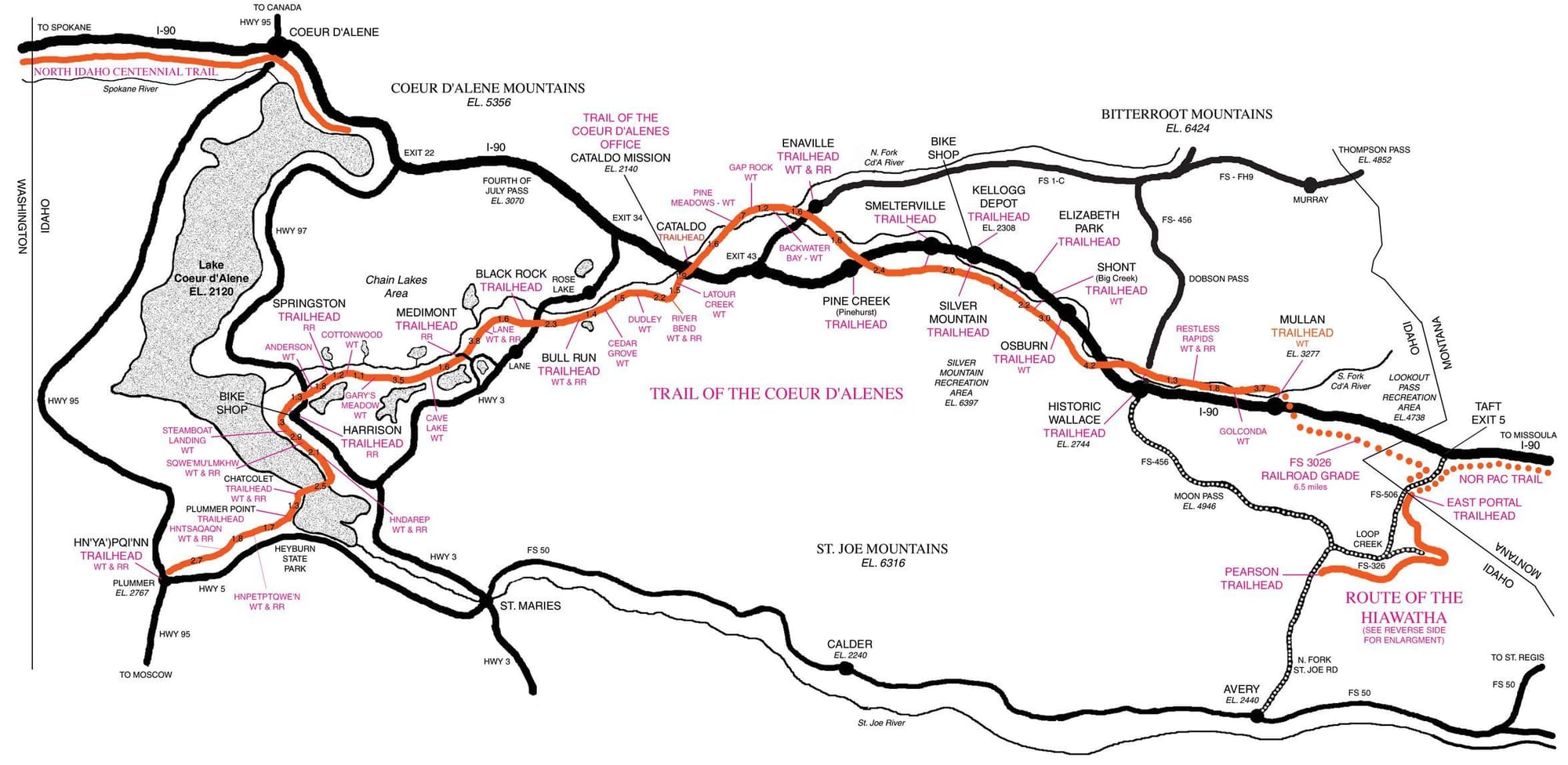
You might take a look at the trail of the Coeur d'alenes. It is a separated paved bike trail that runs from Mulans Idaho to Plummer Idaho. Then it is not far to connect with the Cascade Trail which is gravel/dirt but separated and goes all the way to downtown Seattle.

03-24-22, 02:43 PM
#19
Senior Member
Thread Starter
Join Date: Sep 2015
Location: QC Canada
Posts: 1,962
Bikes: Custom built LHT & Troll
Mentioned: 12 Post(s)
Tagged: 0 Thread(s)
Quoted: 838 Post(s)
Liked 149 Times
in
106 Posts
Mike_Kelly thanks for the advice. (1) I have not yet looked at supply, but I understand. Last summer I crossed Canada (solo) and I had to be careful wrt to food and especially water supply. I was able to average 3 times as much ground so, has never been dramatic. I guess that worse comes to worst, I'll get the extra-wheel out of the locker and play the mule. (2) Correct me if I am wrong, but it looks as if many/most US National Parks have a hike and bike policy. I'll check again (the good thing with short days is that we'll be looking for a campsite at lunch time ; (3) the forest fire situation is probably what concerns me the most. We were in the Canadian Rockies this past summer and have had to purchase post-cards in order to see the mountains -- the smoke was *really* bad.
You know what? Fires here, war there, COVID everywhere -- perhaps we should watch TV after all
; (3) the forest fire situation is probably what concerns me the most. We were in the Canadian Rockies this past summer and have had to purchase post-cards in order to see the mountains -- the smoke was *really* bad. You know what? Fires here, war there, COVID everywhere -- perhaps we should watch TV after all
03-24-22, 03:14 PM
#20
Senior Member
Thread Starter
Join Date: Sep 2015
Location: QC Canada
Posts: 1,962
Bikes: Custom built LHT & Troll
Mentioned: 12 Post(s)
Tagged: 0 Thread(s)
Quoted: 838 Post(s)
Liked 149 Times
in
106 Posts
Here's a revised itinerary Calgary - Jackson Hole, inspired by the many suggestions made above (Ignore waypoints. They are required to plot the course and do not correspond to stages). If I misunderstood your advice, let me know.
One scenario is to ride at a leisurely pace with several zero days, and then fly/train/bus/rent-a-car Jackson Hole > Seattle. OR we'll cover more/faster ground and ride another route across Idaho/Washington. (Life is definitely too short)
One scenario is to ride at a leisurely pace with several zero days, and then fly/train/bus/rent-a-car Jackson Hole > Seattle. OR we'll cover more/faster ground and ride another route across Idaho/Washington. (Life is definitely too short)
03-24-22, 04:12 PM
#21
Senior Member
Join Date: Aug 2010
Location: Madison, WI
Posts: 11,182
Bikes: 1961 Ideor, 1966 Perfekt 3 Speed AB Hub, 1994 Bridgestone MB-6, 2006 Airnimal Joey, 2009 Thorn Sherpa, 2013 Thorn Nomad MkII, 2015 VO Pass Hunter, 2017 Lynskey Backroad, 2017 Raleigh Gran Prix, 1980s Bianchi Mixte on a trainer. Others are now gone.
Mentioned: 47 Post(s)
Tagged: 0 Thread(s)
Quoted: 3455 Post(s)
Liked 1,454 Times
in
1,133 Posts
That looks like an outstanding route. If you do that, I would appreciate getting a copy of the GPX file later if you create a GPS track.
That distance is just a hair over my Canadian Maritimes trip distance three years ago. I rode that at a leisurely pace, took several extra days off for weather, etc. In your case you will have family, thus need to be somewhat leisurely. I think you are going to have a great time.
But, the one thing I would keep in mind, that day I rode from Waterton Park to East Glacier, some of the hills were quite steep and if you have an 11 year old, that might not be the most pleasant day. That was the first of the two elevation profiles I posted above in post number 7.
I do not remember when you would be going over Going to the Sun Road, but that road does not open up until ... I will let others with more recent knowledge than me cite that schedule to watch.
03-25-22, 07:15 AM
#22
Senior Member
Thread Starter
Join Date: Sep 2015
Location: QC Canada
Posts: 1,962
Bikes: Custom built LHT & Troll
Mentioned: 12 Post(s)
Tagged: 0 Thread(s)
Quoted: 838 Post(s)
Liked 149 Times
in
106 Posts
In the coming days I'll review it and break it down into dailies.
03-25-22, 07:22 AM
#23
Senior Member
Join Date: Aug 2010
Location: Madison, WI
Posts: 11,182
Bikes: 1961 Ideor, 1966 Perfekt 3 Speed AB Hub, 1994 Bridgestone MB-6, 2006 Airnimal Joey, 2009 Thorn Sherpa, 2013 Thorn Nomad MkII, 2015 VO Pass Hunter, 2017 Lynskey Backroad, 2017 Raleigh Gran Prix, 1980s Bianchi Mixte on a trainer. Others are now gone.
Mentioned: 47 Post(s)
Tagged: 0 Thread(s)
Quoted: 3455 Post(s)
Liked 1,454 Times
in
1,133 Posts
This is the GPX file generated by brouter for the revised itinerary.
In the coming days I'll review it and break it down into dailies.
In the coming days I'll review it and break it down into dailies.
Likes For Tourist in MSN:
03-25-22, 08:15 AM
#24
cyclotourist
Join Date: Jul 2002
Location: calgary, canada
Posts: 1,470
Mentioned: 2 Post(s)
Tagged: 0 Thread(s)
Quoted: 443 Post(s)
Liked 205 Times
in
130 Posts
I am in general agreement with jama et. al. to change your route and ride Going to the Sun. It is one of my favourite rides and is much more rewarding than following the GDMBR on the west side of the divide.
I have ridden that portion of the Great Divide route Kananaskis to Sparwood, it is pretty straight forward, I remember one place where you had to push your bike.
If you ride the Spray Lakes/ Smith Dorrien road in Kananaskis, it is the dustiest most horrible road in Alberta, especially on weekends. The alternative High Rockies trail is fun but has a lot of up and down that might be exhausting on a loaded bike.
Sounds like a fantastic trip, hope you guys have good weather.
Likes For skookum:
03-25-22, 10:42 AM
#25
Hooked on Touring
If it is later in the summer and has been dry, then yes - it can be bad.
But they will be hitting it fairly early - may even be a bit coolish and wet.
One time when I rode it is was a sunny cool day - rained the day before.
It was almost like pavement and there was zero traffic.
YMMV.