


Route Planning - I can't do it without "The Strava Matrix"
 10-24-19, 09:57 AM
#1
meh
Thread Starter

Join Date: Jul 2014
Location: Hopkins, MN
Posts: 4,704
Bikes: 23 Cutthroat, 21 CoMotion Java; 21 Bianchi Infinito; 15 Surly Pugsley; 11 Globe Daily; 09 Kona Dew Drop; 96 Mondonico
Mentioned: 22 Post(s)
Tagged: 0 Thread(s)
Quoted: 1110 Post(s)
Liked 1,013 Times
in
519 Posts
Route Planning - I can't do it without "The Strava Matrix"
I find it kinda funny that I can't route plan without seeing the Strava Heatmap... it's like reading The Matrix code, people that don't ride won't be able to read it.
Anybody else find Strava Heatmaps critical when planning a route? Other tools you find helpful at picking the best route from here-to-there?
Footnote: I just finished 3 endurance races in 4 weeks, I'm taking some recovery time ... so I've got more screen time to post these random thoughts.
Anybody else find Strava Heatmaps critical when planning a route? Other tools you find helpful at picking the best route from here-to-there?
Footnote: I just finished 3 endurance races in 4 weeks, I'm taking some recovery time ... so I've got more screen time to post these random thoughts.
 10-24-19, 10:09 AM
#2

Senior Member
Join Date: Oct 2011
Location: Phx, AZ
Posts: 2,114
Bikes: Trek Mtn Bike
Mentioned: 5 Post(s)
Tagged: 0 Thread(s)
Quoted: 282 Post(s)
Liked 2,641 Times
in
948 Posts
Critical? No. But useful in seeing routes I would never have thought of.
Sometimes those really faint traces are crossing city and utility No Trespassing zones. Sometimes the No Trespassing signs are serious. Sometimes they are ridiculous.
Sometimes those really faint traces are crossing city and utility No Trespassing zones. Sometimes the No Trespassing signs are serious. Sometimes they are ridiculous.
10-24-19, 11:03 AM
#3
Senior Member
Join Date: Jan 2010
Posts: 39,235
Mentioned: 211 Post(s)
Tagged: 1 Thread(s)
Quoted: 18411 Post(s)
Liked 15,531 Times
in
7,327 Posts
No.
10-24-19, 11:20 AM
#4
Senior Member

Join Date: Jul 2002
Location: Sacramento, California, USA
Posts: 40,865
Bikes: Specialized Tarmac, Canyon Exceed, Specialized Transition, Ellsworth Roots, Ridley Excalibur
Mentioned: 68 Post(s)
Tagged: 0 Thread(s)
Quoted: 2952 Post(s)
Liked 3,106 Times
in
1,417 Posts
They're pretty useful, but just part of the consideration. The funny part is when you see the trace for a circuit out in the middle of BFE and you realize it's the course of an annual race.
10-24-19, 11:29 AM
#5
meh
Thread Starter
Join Date: Jul 2014
Location: Hopkins, MN
Posts: 4,704
Bikes: 23 Cutthroat, 21 CoMotion Java; 21 Bianchi Infinito; 15 Surly Pugsley; 11 Globe Daily; 09 Kona Dew Drop; 96 Mondonico
Mentioned: 22 Post(s)
Tagged: 0 Thread(s)
Quoted: 1110 Post(s)
Liked 1,013 Times
in
519 Posts
When planning a ride into the unknown, I create the route with the Heatmap, then cross-reference with Google Street View to make sure the roads are what I expect. But I've been stuck where the Street View was out of date and had the need to get creative.
Likes For Hypno Toad:
10-24-19, 12:23 PM
#6
Senior Member

Join Date: Nov 2014
Location: Eugene, Oregon, USA
Posts: 27,547
Mentioned: 217 Post(s)
Tagged: 0 Thread(s)
Quoted: 18373 Post(s)
Liked 4,508 Times
in
3,351 Posts
Hmmm...
I don't get into the Heatmaps very frequently.
One issue that I've had with the Route Planner was that in the past it seemed to dislike certain bike friendly roads. (used to choose Highway 99 over Sears Road).
Just tried it again today, and it seems to pick the correct road.
I suppose the heat map might help one understand options, but there is more to route planning.
Likes For CliffordK:
10-24-19, 01:15 PM
#7
Senior Member
Join Date: Jul 2006
Posts: 3,063
Mentioned: 63 Post(s)
Tagged: 0 Thread(s)
Quoted: 1216 Post(s)
Liked 185 Times
in
116 Posts
I prefer regular google maps and streetview to determine if it's a safe road to ride. Where other cyclists ride is often not where I want to go, so the heatmap is not helpful.
Likes For Spoonrobot:

Likes For Milton Keynes:
10-25-19, 03:49 AM
#9
In Real Life

Join Date: Jan 2003
Location: Down under down under
Posts: 52,152
Bikes: Lots
Mentioned: 141 Post(s)
Tagged: 0 Thread(s)
Quoted: 3203 Post(s)
Liked 596 Times
in
329 Posts
I find it kinda funny that I can't route plan without seeing the Strava Heatmap... it's like reading The Matrix code, people that don't ride won't be able to read it.
Anybody else find Strava Heatmaps critical when planning a route? Other tools you find helpful at picking the best route from here-to-there?
Anybody else find Strava Heatmaps critical when planning a route? Other tools you find helpful at picking the best route from here-to-there?
I use Google Maps and Ride With GPS.
__________________
Rowan
My fave photo threads on BF
Century A Month Facebook Group
Machka's Website
Photo Gallery
Rowan
My fave photo threads on BF
Century A Month Facebook Group
Machka's Website
Photo Gallery
10-25-19, 05:53 AM
#10
Senior Member
Join Date: Jul 2017
Location: Pacific Northwest
Posts: 1,993
Bikes: Argon 18 Gallium, BH G7, Rocky Mountain Instinct C70
Mentioned: 11 Post(s)
Tagged: 0 Thread(s)
Quoted: 800 Post(s)
Liked 512 Times
in
306 Posts
Wait what's a Strava?
Seriously though. Whatever happened to just getting on your bike and riding for the fun? Seeing where the bike will take you?
Seriously though. Whatever happened to just getting on your bike and riding for the fun? Seeing where the bike will take you?
10-25-19, 06:06 AM
#11
Senior Member
It might only be on the pay-for version of Strava, but if you use Strava to route plan there is an option like "use popular routes" where Strava will maximize the use of segments that are used the most in the heat map.
I'm laying out a 5 day ride from Venice FL to Jacksonville FL and there are some interesting differences in routes when you turn that option on/off or if you compare when it is on to Google maps or RideWithGPS routing. Usually results in a longer routing but if you do the Google Satellite view comparison, you can often see why.
You can try it out on local routing and see how it compares to what you would normally choose - it is pretty good.
10-25-19, 06:50 AM
#12
meh
Thread Starter
Join Date: Jul 2014
Location: Hopkins, MN
Posts: 4,704
Bikes: 23 Cutthroat, 21 CoMotion Java; 21 Bianchi Infinito; 15 Surly Pugsley; 11 Globe Daily; 09 Kona Dew Drop; 96 Mondonico
Mentioned: 22 Post(s)
Tagged: 0 Thread(s)
Quoted: 1110 Post(s)
Liked 1,013 Times
in
519 Posts
I take many rides with little more than a general idea where I want to go and other days I have a specific destination and a route .... and let's not forget those days when you have a planned route but construction (or other roadblocks) cause you to totally recalculate.
10-25-19, 07:01 AM
#13
Senior Member
Join Date: Dec 2010
Location: northern Deep South
Posts: 8,901
Bikes: Fuji Touring, Novara Randonee
Mentioned: 36 Post(s)
Tagged: 0 Thread(s)
Quoted: 2604 Post(s)
Liked 1,928 Times
in
1,210 Posts
At least in my area, I've been on most of the roads so I try to "drive" Strava to the best routes. Of course, there are those who are afraid to ride with cars; they don't have a lot of places to ride here, anyways. Sorry.
Occasionally on travel I've found a neat trail or route using Strava. My success is mixed, at best. At least of the most popular routes I find, I start asking, "Why would anyone ride a bike HERE?" Of course, that may be the effect of the big supported rides.
Occasionally on travel I've found a neat trail or route using Strava. My success is mixed, at best. At least of the most popular routes I find, I start asking, "Why would anyone ride a bike HERE?" Of course, that may be the effect of the big supported rides.
10-25-19, 07:04 AM
#14
Senior Member
Join Date: Oct 2013
Location: Mich
Posts: 7,386
Bikes: RSO E-tire dropper fixie brifter
Mentioned: 0 Post(s)
Tagged: 0 Thread(s)
Quoted: 6 Post(s)
Liked 2,968 Times
in
1,917 Posts
The construction is so disorganized locally, that the best of the best free "maps" are always outdated.
Therefore, i just incorporate the time I'd have used doing any route planning into the ride itself. 00.02
Therefore, i just incorporate the time I'd have used doing any route planning into the ride itself. 00.02
__________________
-Oh Hey!
-Oh Hey!
10-25-19, 07:04 AM
#15

Non omnino gravis

I hope people aren't using my rides to help build their routes. On a typical day, I might see 1 or 2 other bikes- not because no one is out riding, but because no one is out riding where I am.
I generally feel safer around cars (or commercial vehicles) than I do around groups of cyclists.
That said, I have used the Heatmaps a few times to plot new routes. I've used the thing where Strava will build a route to a desired length as well, but always end up tweaking it a bit.
I generally feel safer around cars (or commercial vehicles) than I do around groups of cyclists.
That said, I have used the Heatmaps a few times to plot new routes. I've used the thing where Strava will build a route to a desired length as well, but always end up tweaking it a bit.
__________________

Likes For DrIsotope:
10-25-19, 07:07 AM
#16
vespertine member

Join Date: Jul 2013
Location: Land of Angora, Turkey
Posts: 2,476
Bikes: Yes
Mentioned: 22 Post(s)
Tagged: 0 Thread(s)
Quoted: 687 Post(s)
Liked 220 Times
in
163 Posts
I found Strava heatmaps useful for planning routes after moving to a new area. I found that the local club routes tended to start out in the country, which is great if you want to drive somewhere and make a day of it, but not ideal for a quick 1-2 hour road ride from home.
The first few routes I planned were great - interesting rolling terrain, most drivers passed properly, and I even saw a few yellow 'Share the Road' signs! I also put together a transpo ride that managed to get me between two cities without getting killed.
I currently live in the land of narrow, shoulderless, high traffic roads, so Google street view - my previous go-to - makes every possible route look intimidating. I'll use Strava to see which of those nasty narrow roads tend to be used by cyclists, then integrate them in to a Ride With GPS route to use for actual navigation.
Likes For wipekitty:
10-25-19, 07:30 AM
#17
Senior Member

Join Date: Jul 2010
Location: Michigan
Posts: 4,863
Bikes: too many of all kinds
Mentioned: 35 Post(s)
Tagged: 0 Thread(s)
Quoted: 1147 Post(s)
Liked 415 Times
in
335 Posts
Agreed, it is great for route planning - especially if I'm looking at google to try to figure out if I can connect 2 segments. Strava will tell me if its been done before, and how often. Its also great for finding ideas that I wouldn't have though of on my own. And of course very handy when going to new locations. But its the faintly used routes that I find the most interesting.
There are some obvious limitations. A race course or club ride route comes out bold when it may or may not be the best. I'll see 30-40 people doing a club ride on sunday morning, burning in a route that is a nightmare to ride during the week when there is traffic on the road.
Still, it gives me a good way to get off the beaten path - I tend to seek out the places with faint lines, that only the locals or adventurous will go to...
Likes For chas58:
10-25-19, 07:54 AM
#18
meh
Thread Starter
Join Date: Jul 2014
Location: Hopkins, MN
Posts: 4,704
Bikes: 23 Cutthroat, 21 CoMotion Java; 21 Bianchi Infinito; 15 Surly Pugsley; 11 Globe Daily; 09 Kona Dew Drop; 96 Mondonico
Mentioned: 22 Post(s)
Tagged: 0 Thread(s)
Quoted: 1110 Post(s)
Liked 1,013 Times
in
519 Posts
Google maps and street view are a key tool to planning a new route, but the my first tool is Strava heat maps.
For a little additional background on my Strava love: I'm also a VeloViewer fan - it's like your Strava data dialed all the way up to 11. Within VeloViewer I have been having fun with the Explore - Max Square. It's esoteric, but has been a fun way to challenge me to ride places I wouldn't typically go.
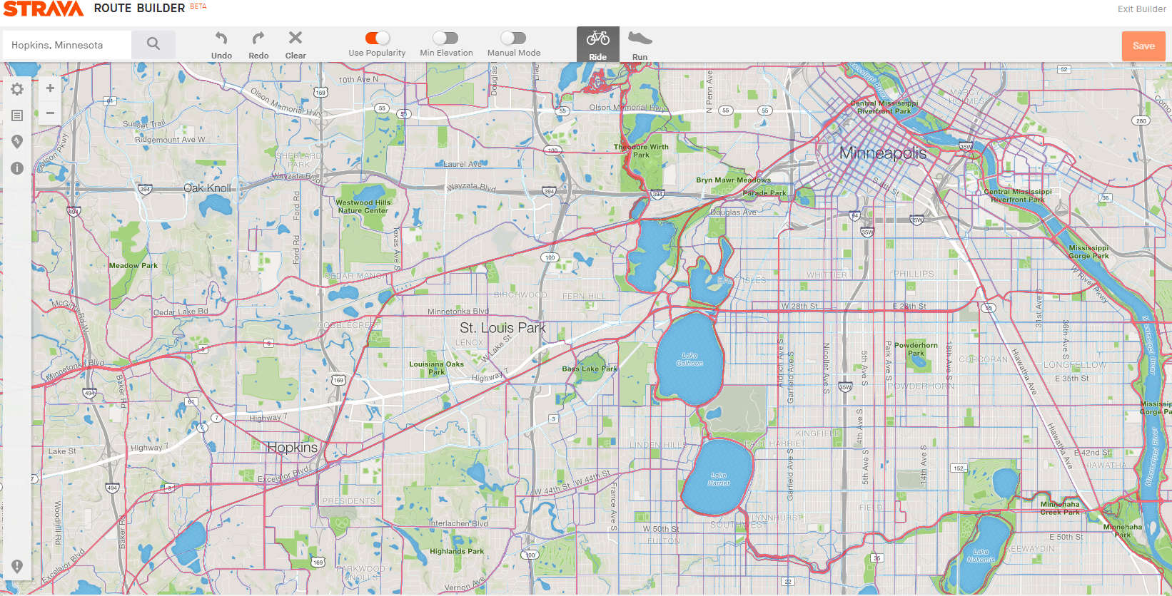
This is how Strava route builder looks with the VeloViewer Explorer plug-in on Chrome.
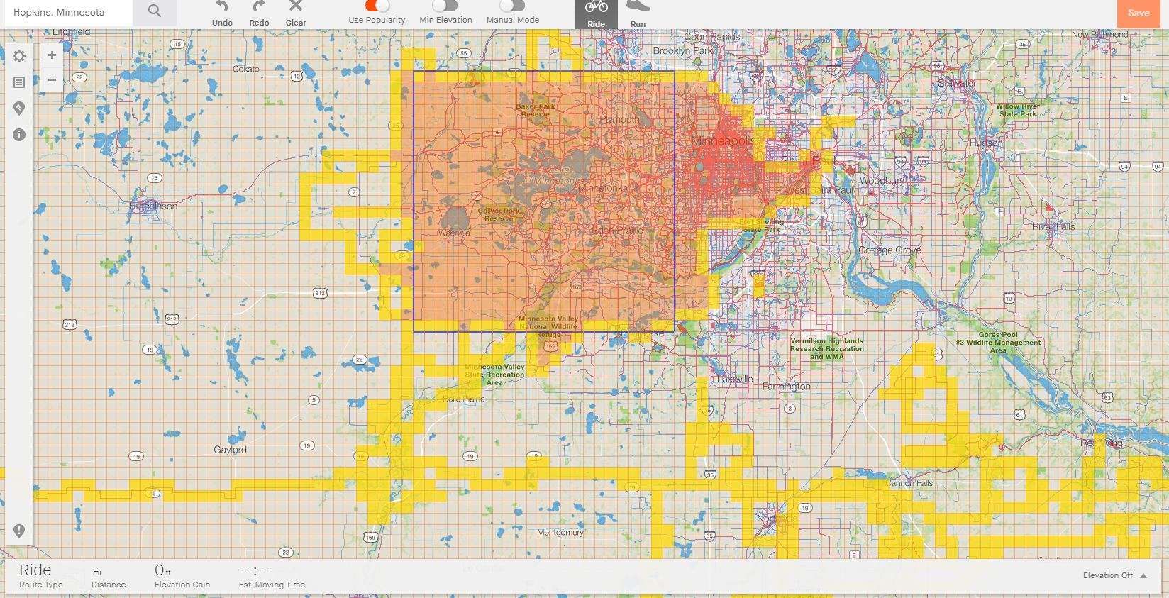
Layered over Strava's heat map:
The blue square is my 'max square' (23x)
Yellow (& orange) squares are grids I've biked through
Orange blob is the max cluster (alternative for people that live in a place where the geography doesn't allow a square)
Last edited by Hypno Toad; 10-25-19 at 08:13 AM. Reason: adding clarification
10-25-19, 09:12 AM
#19
Senior Member
I like Strava Heat Maps, but you have to be careful around my area. A large club rides in my area on the weekends along several routes depending on the group (A, B, C, extended, etc.), and it creates the illusion on the heat map that some roads may be good for a weekday ride. A couple of roads that are popular with cyclists on the weekends have no shoulder and have a constant flow of gravel haulers and cement trucks all day long on Mon-Fri. It would be great if you could narrow it down by the day of the week traveled, or at least weekend vs. weekday. A lot of gravel riders around here to; so you need to check the road surfaces closely as well if you only want pavement.
Likes For jeffreythree:
10-25-19, 09:24 AM
#20
Senior Member

Join Date: Dec 2007
Location: Central Illinois
Posts: 869
Bikes: 2008 Dawes Haymaker 20XX Leader LD515 TotoCycling Road Bike
Mentioned: 0 Post(s)
Tagged: 0 Thread(s)
Quoted: 27 Post(s)
Likes: 0
Liked 32 Times
in
19 Posts
I make it a point to go down roads I never traveled, unless they are dangerous.
10-25-19, 10:21 AM
#21
meh
Thread Starter
Join Date: Jul 2014
Location: Hopkins, MN
Posts: 4,704
Bikes: 23 Cutthroat, 21 CoMotion Java; 21 Bianchi Infinito; 15 Surly Pugsley; 11 Globe Daily; 09 Kona Dew Drop; 96 Mondonico
Mentioned: 22 Post(s)
Tagged: 0 Thread(s)
Quoted: 1110 Post(s)
Liked 1,013 Times
in
519 Posts
I always enjoy these kinda threads, I learn and think about things differently.
As a result, I figured out how to export the Strava .gpx and then import it to Google maps and have an easy way to check roads with Googles satellite view.
If there's one thing I dislike about Strava's route tool, it's the ability to zoom in with the satellite view ... you can't get detailed enough to see if the road has a shoulder or a bike lane; or if the road surface is gravel or paved. That's where Google maps is critical to my route planning.
Likes For Hypno Toad:
10-25-19, 11:24 AM
#22
Senior Member
Join Date: Mar 2006
Location: Chicago, IL, USA
Posts: 2,880
Mentioned: 2 Post(s)
Tagged: 0 Thread(s)
Quoted: 1461 Post(s)
Liked 1,481 Times
in
870 Posts
I've never been one to plot out exact turn-by-turn routes and follow them on my GPS, but Strava Heatmaps was a great tool for scouting out routes for a vacation I took over the summer to an area where I wasn't familiar with the roads. There were a lot of 55mph roads with no shoulders in the area that would've really sucked to ride on and scouting out the heatmap ahead of time helped me familiarize myself with the area, avoid those types of roads and gave me enough info to feel confident just heading out and "winging it" on a few point A-B rides.
Strava heat maps also helped me find an awesome singletrack and gravel loop that I would've never found on my own just riding around.
Strava heat maps also helped me find an awesome singletrack and gravel loop that I would've never found on my own just riding around.
Likes For msu2001la:
10-25-19, 12:25 PM
#23
Newbie racer
Join Date: Feb 2018
Posts: 3,406
Bikes: Propel, red is faster
Mentioned: 34 Post(s)
Tagged: 0 Thread(s)
Quoted: 1575 Post(s)
Liked 1,569 Times
in
974 Posts
You realize you can also turn on segments to plan routes. Good bet if there�s thousands if attempts on something it�s decent. Also, keep open Google maps in cycling mode to compare.
I am too much of a rule follower to ever do the whole mountain biker �bandit trail� thing.
I am too much of a rule follower to ever do the whole mountain biker �bandit trail� thing.
10-25-19, 05:00 PM
#24
Senior Member
I always enjoy these kinda threads, I learn and think about things differently.
As a result, I figured out how to export the Strava .gpx and then import it to Google maps and have an easy way to check roads with Googles satellite view.
If there's one thing I dislike about Strava's route tool, it's the ability to zoom in with the satellite view ... you can't get detailed enough to see if the road has a shoulder or a bike lane; or if the road surface is gravel or paved. That's where Google maps is critical to my route planning.
As a result, I figured out how to export the Strava .gpx and then import it to Google maps and have an easy way to check roads with Googles satellite view.
If there's one thing I dislike about Strava's route tool, it's the ability to zoom in with the satellite view ... you can't get detailed enough to see if the road has a shoulder or a bike lane; or if the road surface is gravel or paved. That's where Google maps is critical to my route planning.
Likes For jeffreythree:
10-26-19, 09:24 AM
#25
Rouleur

I like Strava a lot as a way to track my rides, get an idea for what's around me, analyze my speed / distance / power / elevation / physical data, and to just see where others have ridden. But mapping out rides? I don't think I've ever done that with one exception - I found the Route Builder and was able to make a course that gave me 9,580 ft. of climbing over 72 miles. I have never even looked at the Heat Map. Besides, the most fun I ever have on a bike ride is to go "get lost" for a few hours, then take out my phone to see where I am and how the he** I'm going to get home.