


Touring humor? "Ohio Triangle"
 09-19-21, 10:37 AM
#1
Senior Member
Thread Starter
Join Date: Apr 2013
Posts: 1,173
Bikes: Surly Disk Trucker, 2014 w/Brooks Flyer Special saddle, Tubus racks - Duo front/Logo Evo rear, 2019 Dahon Mariner D8, Both bikes share Ortlieb Packer Plus series panniers, Garmin Edge 1000
Mentioned: 2 Post(s)
Tagged: 0 Thread(s)
Quoted: 405 Post(s)
Liked 115 Times
in
99 Posts
Touring humor? "Ohio Triangle"
I got a good laugh when I saw this.
Has anyone ever rode this - what appears to be the "Ohio Triangle"? Perhaps they started and never returned?
For those that haven't caught the joke, the pun is on the Bermuda Triangle.

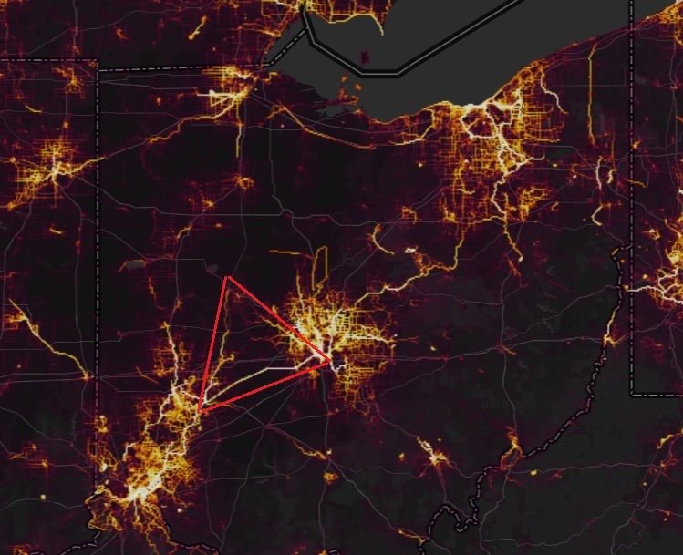
I traced it in red here for more clarity. That is Bellefontaine to the North, SW Columbus to the East, and Xenia to the South West.
Has anyone ever rode this - what appears to be the "Ohio Triangle"? Perhaps they started and never returned?
For those that haven't caught the joke, the pun is on the Bermuda Triangle.
I traced it in red here for more clarity. That is Bellefontaine to the North, SW Columbus to the East, and Xenia to the South West.

Likes For KC8QVO:
09-21-21, 06:38 PM
#2
Senior Member

Yes, back 45years ago when I was at Ohio State, the OSU cycling club did a three-day weekend ride to Yellow Springs/Kettering, then north to Bellfontaine, and back to campus... Obviously I survived since I am posting this... But, come to think of it, I haven't seen any of my fellow cycling club members here on BF.net... 
Likes For Cougrrcj:
09-21-21, 07:41 PM
#3
Senior Member

Join Date: Jun 2020
Location: Ohio
Posts: 523
Bikes: 2021 Kona Sutra, Ragley parts-cycle
Mentioned: 1 Post(s)
Tagged: 0 Thread(s)
Quoted: 128 Post(s)
Liked 1,242 Times
in
336 Posts
https://goo.gl/maps/Y7NV6qMR5xfR13ry8
164ish miles, 1650ft up, 1654 down (if goog is to be believed)...not sure what the road riding is between Bellefontaine and Cowtown, but on the surface it doesn't look too bad for a short tour...
164ish miles, 1650ft up, 1654 down (if goog is to be believed)...not sure what the road riding is between Bellefontaine and Cowtown, but on the surface it doesn't look too bad for a short tour...
09-21-21, 08:36 PM
#4
Senior Member
Thread Starter
Join Date: Apr 2013
Posts: 1,173
Bikes: Surly Disk Trucker, 2014 w/Brooks Flyer Special saddle, Tubus racks - Duo front/Logo Evo rear, 2019 Dahon Mariner D8, Both bikes share Ortlieb Packer Plus series panniers, Garmin Edge 1000
Mentioned: 2 Post(s)
Tagged: 0 Thread(s)
Quoted: 405 Post(s)
Liked 115 Times
in
99 Posts
https://goo.gl/maps/Y7NV6qMR5xfR13ry8
164ish miles, 1650ft up, 1654 down (if goog is to be believed)...not sure what the road riding is between Bellefontaine and Cowtown, but on the surface it doesn't look too bad for a short tour...
164ish miles, 1650ft up, 1654 down (if goog is to be believed)...not sure what the road riding is between Bellefontaine and Cowtown, but on the surface it doesn't look too bad for a short tour...
As to the elevation - I could have told you pretty quick Bellefontaine was a decent climb. The highest point in the sate is in that area (campbell hill). So it makes sense the general elevation is up going that direction from anywhere else. The elevation graph on that route plan shows exactly that.
I think it would be a neat ride at some point, also. However, the trail out of Urbana going North is unpaved. My trek I want to get in this season will take me through there so I may be able to do some test riding on that trail surface before I hit the roads. We'll see.


