


Aliso Creek Bike Path to the beach on road bike?
 04-05-20, 08:15 AM
#1
Newbie
Thread Starter
Join Date: Apr 2020
Posts: 2
Mentioned: 0 Post(s)
Tagged: 0 Thread(s)
Quoted: 0 Post(s)
Likes: 0
Liked 0 Times
in
0 Posts
Aliso Creek Bike Path to the beach on road bike?
Hello!
If you ride down the Aliso Creek Bike Path toward Laguna Beach, just after you pass the water treatment plan, there is a fence that says private property blocking the path and making it so you cannot take the path into Laguna Beach. Is this normally fenced off or is there typically access? It would be great to road bike from Aliso Viejo to the beach, and I am unaware of other paths. Any advice? Thank you
-Angie
 04-05-20, 02:52 PM
#2
Senior Member
Join Date: May 2001
Location: Sunny so. cal.
Posts: 904
Mentioned: 1 Post(s)
Tagged: 0 Thread(s)
Quoted: 136 Post(s)
Liked 57 Times
in
31 Posts
That road has never gone through. The only way to Laguna Beach is via Hwy 133/Laguna Canyon or to South Laguna via Crown Valley Parkway.
Alternative ideas:
It isn't Laguna but you can take the path which originates by Cook's Corner to San Juan Capistrano and Dana Point using frontage roads once in Laguna Hills and then back to bike paths again in SJC. If you use Google Maps on Bike mode, it'll show you the route.
Or go to Salt Creek: continue heading down Alicia where path ends at Aliso-Wood Canyon/AMWA Road, then turn right at Crown Valley Pkwy, left at Camino del Avion, then right onto bike path that ends at Salt Creek beach. The latter route is 3/4 road, 1/4 path. To get to Laguna Proper, your only choice from inland is down Hwy 133/Laguna Canyon Road.
Last edited by bikeme; 04-05-20 at 02:56 PM.
04-05-20, 03:08 PM
#3
Junior Member
Amvoss, just over that fence is The Ranch at Laguna Beach (or as it was formerly known, Aliso Creek Golf Course). The county has had high hopes to take the bike path through the course property and all the way to PCH for over 20 years. Unless The Ranch at Laguna Beach is sold, those hopes will remain unrealized.
04-05-20, 05:19 PM
#4
Full Member
Join Date: Jan 2013
Location: Oakland CA
Posts: 274
Bikes: 1984 Gitane TdF, 1986 Look �quipe, 1983 Colnago Super
Mentioned: 2 Post(s)
Tagged: 0 Thread(s)
Quoted: 113 Post(s)
Liked 137 Times
in
80 Posts
Have you tried Google Maps? Not everyone knows this, but if you click on the 3 bars in the upper left corner, you can select Bicycling and it shows all the local bike routes. I use it all the time.
It may not be ideal, but here's what I saw:
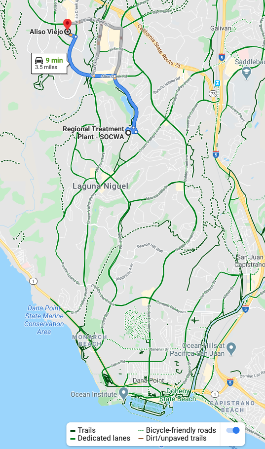
It may not be ideal, but here's what I saw:
04-06-20, 10:50 AM
#7
Pennylane Splitter
Join Date: Sep 2012
Location: Orange County, California
Posts: 1,878
Bikes: Yes
Mentioned: 14 Post(s)
Tagged: 0 Thread(s)
Quoted: 1789 Post(s)
Liked 1,439 Times
in
989 Posts
Two issues with the southern terminus of the path:
Just below the first gate is the SOCWA's Aliso Creek wastewater treatment plant (I used to work for the agency that runs it) . Its not the one shown in the google-maps image shown above. You cant see it from the gate, but its there. With all the equipment, chemicals and processes going on at that place, they definitely don't want strangers passing directly next to it for security reasons.
Beyond the plant is the back entrance to the Golf Course (formerly known as the Ben Brown resort). There's a dirt berm between the treatment plant and the golf course, and a gate in the berm between the two. If you go through the gate you'd be on a path that goes through the golf course, not an ideal situation with golf balls flying around (liability).
10-30-20, 02:18 PM
#8
FIXED GEAR
Join Date: Oct 2020
Posts: 47
Bikes: 2019 tarmac pro disc 2020 allez sprint track
Mentioned: 0 Post(s)
Tagged: 0 Thread(s)
Quoted: 14 Post(s)
Likes: 0
Liked 36 Times
in
14 Posts
The new owners of the ranch formerly Ben browns and the city of laguna were working on getting public access so you could connect to coast hwy. However do to red tape, money, politics, etc etc it�s not happening maybe one day.
It seems like it should be a public right of way or just wall and fence the hell out of the path so there�s no issues
It seems like it should be a public right of way or just wall and fence the hell out of the path so there�s no issues
Likes For Ymerej:
