


Elevation gain
 07-26-21, 06:26 PM
#51
Perceptual Dullard
Join Date: Sep 2009
Posts: 2,410
Mentioned: 36 Post(s)
Tagged: 0 Thread(s)
Quoted: 914 Post(s)
Liked 1,131 Times
in
487 Posts
There is a distance, and there is a measurement of that distance.
 07-26-21, 08:45 PM
#52

climber has-been

Join Date: Dec 2004
Location: Palo Alto, CA
Posts: 7,084
Bikes: Scott Addict R1, Felt Z1
Mentioned: 10 Post(s)
Tagged: 0 Thread(s)
Quoted: 3408 Post(s)
Liked 3,540 Times
in
1,782 Posts
That's a different problem. Are you saying that if I hold my hand above a table top, there is no "right" distance between my hand and the table top? You can't measure a distance between two points unless they're connected? How about distance in the vacuum of space? In fact, the meter is defined as 1/299792458 of the distance light travels in a vacuum in one second, so we can certainly measure a distance in a vacuum.
There is a distance, and there is a measurement of that distance.
There is a distance, and there is a measurement of that distance.
Of course, it�s simple to determine the elevation difference between two points. But the accumulated elevation gain between two points is path dependent. And you will get a different result if you use a different length ruler.
07-26-21, 10:18 PM
#53
Me duelen las nalgas
Join Date: Aug 2015
Location: Texas
Posts: 13,513
Bikes: Centurion Ironman, Trek 5900, Univega Via Carisma, Globe Carmel
Mentioned: 199 Post(s)
Tagged: 0 Thread(s)
Quoted: 4559 Post(s)
Liked 2,802 Times
in
1,800 Posts
They are not. Strava still suffers from the inaccuracy of data that users upload.
Like this Strava segment, based on some very noisy user-uploaded data.
The actual grade is about 7%, but Strava says it's 12.3%. Strava says the KOM rider climbed it with a VAM of 2703 meters per hour, which is ridiculous.
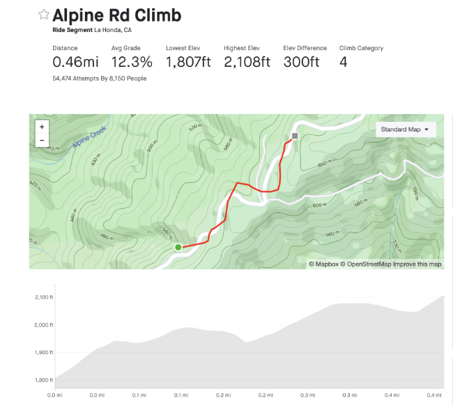
Bad Strava segment
Here's what that segment would look like with "good" GPS data:

"good" Strava segment
Like this Strava segment, based on some very noisy user-uploaded data.
The actual grade is about 7%, but Strava says it's 12.3%. Strava says the KOM rider climbed it with a VAM of 2703 meters per hour, which is ridiculous.
Bad Strava segment
Here's what that segment would look like with "good" GPS data:
"good" Strava segment
My hunch is that Strava defers to the data uploaded by our apps and computers. I usually ride with both a computer (XOSS G+ with barometer) and phone app (usually Wahoo Fitness) as a backup. When I upload two files from two different devices the biggest difference is usually in elevation and terrain profile. In particular the XOSS G+ data produces terrain profiles that look like something drawn with an Etch A Sketch, and barely resembles the actual elevation gain, slopes or terrain profile. Other bike computers with barometers might be better. The XOSS isn't bad for $25-$50 but not a precision instrument.
But when I click the option to correct elevation, the elevation gain and terrain profile usually match most rides on the same route, and seems to correspond with what I've seen and measured. On some routes I've used a phone app to physically measure the grade on some of our short, steep climbs that seemed to be double digits -- we have no mountains here, few extended gradual inclines, and many short, steep punchy hillettes. My measurements usually correspond with Strava's data.
Regarding KOMs on some Strava segments, with the earliest segments created by first users, there's a lot of garbage-in/garbage-out. Some of the earliest Strava segments created here are so ridiculous many of us have created modified segments along the same routes to get something closer to reality. There's one in my area that claims to be a 30% or so grade. There's nothing remotely resembling that in this entire area. Other segments were created using GPS traces that were choppy or wildly off -- such as requiring subsequent cyclists to ride on the opposite side of the road against traffic, or riding through someone's front yard. The people who created those segments should have re-ridden the route to create segments closer to reality, but they didn't.
07-27-21, 12:59 AM
#54
Perceptual Dullard
Join Date: Sep 2009
Posts: 2,410
Mentioned: 36 Post(s)
Tagged: 0 Thread(s)
Quoted: 914 Post(s)
Liked 1,131 Times
in
487 Posts
The accumulated elevation gain is the problem of interest to cyclists, and it’s analogous to the “length of a coastline” problem.
Of course, it’s simple to determine the elevation difference between two points. But the accumulated elevation gain between two points is path dependent. And you will get a different result if you use a different length ruler.
Of course, it’s simple to determine the elevation difference between two points. But the accumulated elevation gain between two points is path dependent. And you will get a different result if you use a different length ruler.
And the problem of interest to cyclists isn't quite accumulated elevation gain, it's the energy they will need to climb whatever that accumulated elevation gain is, or perhaps the energy per unit time. Because traditionally cyclists didn't have a way to measure or estimate that energy, they got used to a proxy: elevation gained (although that doesn't exactly describe the energy problem because total elevation gained doesn't tell you how steep the road was). Fortunately, we now have devices that allow us to measure that directly, viz., power meters. So that's what I use: I translate the energy expended into an equivalent amount of climbing. I could have called that equivalent elevation but instead I called it virtual elevation. I actually calculate the virtual gradients for each second of the ride and combine it with the speeds for each second of the ride to get cumulated virtual elevation -- because I do it that way, I get not only the total elevation gained but also its distribution along the way, i.e., the virtual road profile.
07-27-21, 01:09 AM
#55
Senior Member
*Or at least, it's comparable on a hypothetical level. For practical purposes, riding reasonable paved roads on a road bike is usually a smooth-enough situation that the minimum-ruler-length-that-it-makes-sense-to-use isn't that fuzzy of an issue.
 07-27-21, 01:31 AM
#56
Perceptual Dullard
Join Date: Sep 2009
Posts: 2,410
Mentioned: 36 Post(s)
Tagged: 0 Thread(s)
Quoted: 914 Post(s)
Liked 1,131 Times
in
487 Posts
I think you two are talking around each other. In most cycling conversation, the "elevation" or "elevation gain" of a ride usually refers to the cumulative elevation gained while traveling on positive gradients, not the elevation difference between the start and finish of a ride. The former is path-dependent and is comparable to a shoreline problem*, the latter is not.
*Or at least, it's comparable on a hypothetical level. For practical purposes, riding reasonable paved roads on a road bike is usually a smooth-enough situation that the minimum-ruler-length-that-it-makes-sense-to-use isn't that fuzzy of an issue.
*Or at least, it's comparable on a hypothetical level. For practical purposes, riding reasonable paved roads on a road bike is usually a smooth-enough situation that the minimum-ruler-length-that-it-makes-sense-to-use isn't that fuzzy of an issue.
07-27-21, 08:19 AM
#57
I'm good to go!
Join Date: Jul 2017
Location: Mississippi
Posts: 14,949
Bikes: Tarmac Disc Comp Di2 - 2020
Mentioned: 51 Post(s)
Tagged: 0 Thread(s)
Quoted: 6177 Post(s)
Liked 4,794 Times
in
3,306 Posts
That's a different problem. Are you saying that if I hold my hand above a table top, there is no "right" distance between my hand and the table top? You can't measure a distance between two points unless they're connected? How about distance in the vacuum of space? In fact, the meter is defined as 1/299792458 of the distance light travels in a vacuum in one second, so we can certainly measure a distance in a vacuum.
There is a distance, and there is a measurement of that distance.
There is a distance, and there is a measurement of that distance.
As another has said, with barometric sensors, resolution is the issue. Both for the devices ability to sense a certain amount of change reliably and factors that cause noise, unreliable data that have to be taken into account. If I go up and down five feet is that climbing and descending? If I go up and down 1 foot is that climbing and descending?
Getting back to the topo maps, it's possible to ride between the contour lines in places for many miles. That doesn't mean no climbing or descending was taking place unless your resolution has to be 10 feet or more.
07-27-21, 08:37 AM
#58
Perceptual Dullard
Join Date: Sep 2009
Posts: 2,410
Mentioned: 36 Post(s)
Tagged: 0 Thread(s)
Quoted: 914 Post(s)
Liked 1,131 Times
in
487 Posts
If I walk up the 8 foot hill in my yard, did I not climb any distance? That section of my yard is between the 350' and 360' foot contour line. The map data doesn't have the elevation data for every square inch of ground. If I mow my grass in then I'm climbing and descending multiple times that 8' of height, but I won't get any credit for climbing going by map data.
As another has said, with barometric sensors, resolution is the issue. Both for the devices ability to sense a certain amount of change reliably and factors that cause noise, unreliable data that have to be taken into account. If I go up and down five feet is that climbing and descending? If I go up and down 1 foot is that climbing and descending?
Getting back to the topo maps, it's possible to ride between the contour lines in places for many miles. That doesn't mean no climbing or descending was taking place unless your resolution has to be 10 feet or more.
So, yeah, I'd say that each time you're mowing your lawn up hill, I count that.
07-27-21, 08:46 AM
#59
I'm good to go!
Join Date: Jul 2017
Location: Mississippi
Posts: 14,949
Bikes: Tarmac Disc Comp Di2 - 2020
Mentioned: 51 Post(s)
Tagged: 0 Thread(s)
Quoted: 6177 Post(s)
Liked 4,794 Times
in
3,306 Posts
The work it takes to raise a mass m up a height h under the force of gravity g is m*g*h. So that's what I do: rather than measure barometric pressure or GPS elevation gain or worry about resolution, I skip past all of that: I use total work, m, and g, to calculate what h must have been. As a part of that, I get the entire road profile.
So, yeah, I'd say that each time you're mowing your lawn up hill, I count that.
So, yeah, I'd say that each time you're mowing your lawn up hill, I count that.
And even more specifically why some data didn't accumulate to provide the same number.
07-27-21, 09:16 AM
#60
Perceptual Dullard
Join Date: Sep 2009
Posts: 2,410
Mentioned: 36 Post(s)
Tagged: 0 Thread(s)
Quoted: 914 Post(s)
Liked 1,131 Times
in
487 Posts
I side-stepped the cumulation problem a while back by asking, "how much change in height and what gradients would it take so that the energy expended to get you up those hills and across those distances in the amount of time you took is consistent with the observable data?" and ended up showing how to turn an expensive power meter into a cheap altimeter.
Last edited by RChung; 07-27-21 at 03:24 PM.
07-27-21, 02:41 PM
#61
Senior Member
Join Date: Sep 2007
Location: Far beyond the pale horizon.
Posts: 14,258
Mentioned: 31 Post(s)
Tagged: 0 Thread(s)
Quoted: 4244 Post(s)
Liked 1,346 Times
in
934 Posts
The work it takes to raise a mass m up a height h under the force of gravity g is m*g*h. So that's what I do: rather than measure barometric pressure or GPS elevation gain or worry about resolution, I skip past all of that: I use total work, m, and g, to calculate what h must have been. As a part of that, I get the entire road profile.
I side-stepped the cumulation problem a while back by asking, "how much change in height and what gradients would it take so that the energy expended to get you up those hills and across those distances in the amount of time you took is consistent with the observable data?" and ended up showing how to turn an expensive power meter into a cheap altimeter.
Last edited by njkayaker; 07-27-21 at 02:55 PM.
07-27-21, 04:13 PM
#62
Perceptual Dullard
Join Date: Sep 2009
Posts: 2,410
Mentioned: 36 Post(s)
Tagged: 0 Thread(s)
Quoted: 914 Post(s)
Liked 1,131 Times
in
487 Posts
How do you tell the difference in work due to variation in power output versus that due to height? (You'd need speed at least too.)
The link doesn't work.
[Edited to add] Dammit. The link still doesn't work. Hmmm. If you want (not that you need to) you could try copying the link and then dumping the "https:" at the front, but I understand if no one has time for that kind of nonsense.
Last edited by RChung; 07-27-21 at 04:18 PM.
07-27-21, 04:41 PM
#63
Advocatus Diaboli

Join Date: Feb 2015
Location: Wherever I am
Posts: 8,631
Bikes: Merlin Cyrene, Nashbar steel CX
Mentioned: 14 Post(s)
Tagged: 1 Thread(s)
Quoted: 4729 Post(s)
Liked 1,531 Times
in
1,002 Posts
07-27-21, 11:00 PM
#64
climber has-been
Join Date: Dec 2004
Location: Palo Alto, CA
Posts: 7,084
Bikes: Scott Addict R1, Felt Z1
Mentioned: 10 Post(s)
Tagged: 0 Thread(s)
Quoted: 3408 Post(s)
Liked 3,540 Times
in
1,782 Posts
How bendy is your tape measure? The more bendy it is, the more it can follow the tiny contours of the coastline, and you'll get a larger answer.
__________________
Ride, Rest, Repeat. ROUVY: terrymorse

Ride, Rest, Repeat. ROUVY: terrymorse
07-28-21, 01:09 AM
#65
Perceptual Dullard
Join Date: Sep 2009
Posts: 2,410
Mentioned: 36 Post(s)
Tagged: 0 Thread(s)
Quoted: 914 Post(s)
Liked 1,131 Times
in
487 Posts
But more practically, surely the "bendiness" or scale of relevance is a bicycle wheel on the surface of a road. If you believe you can measure the distance traveled with a bike wheel, you don't have to get caught up in measuring around every pebble embedded in the road surface.
07-28-21, 07:50 AM
#66
Senior Member
Join Date: Dec 2010
Location: northern Deep South
Posts: 8,895
Bikes: Fuji Touring, Novara Randonee
Mentioned: 36 Post(s)
Tagged: 0 Thread(s)
Quoted: 2597 Post(s)
Liked 1,924 Times
in
1,208 Posts
Maybe we should turn the question around. Is there a measurement of altitude gain that is clearly wrong? And I think that's what O.P.'s collection is. The wide, 20% of mean standard deviation, variation of climbs over a half-dozen or so repetitions indicates that the measurement is unstable with the given cell-phone GPS instrument. Terry Morse's Strava case is another bad measurement example.
If we start from the premise that we need to identify and correct bad measurements, surely noisy cell phone GPS tracks are one of the very first things to eliminate from consideration. If someone, for whatever reason, wants to track climbing and is having problems running a cell phone tracker, one of the first responses is "cell phone GPS trackers are often unreliable." A simple corollary would be, "get something else to track climbs on your typical route."
I would be somewhat interested in why the O.P.'s route had such divergence. Did the route go through a downtown or near rock faces that would generate spurious points on the GPS track? Did the phone lose track because of tree leaves? Or was it an example of riding in the left tire track generates a different profile than riding on the shoulder?
07-28-21, 07:58 AM
#67
Senior Member
Join Date: Sep 2007
Location: Far beyond the pale horizon.
Posts: 14,258
Mentioned: 31 Post(s)
Tagged: 0 Thread(s)
Quoted: 4244 Post(s)
Liked 1,346 Times
in
934 Posts
Sorry. I *think* I fixed it and it should work now. That said, it's not key -- I just linked to it because it had a few visual examples from long ago.
[Edited to add] Dammit. The link still doesn't work. Hmmm. If you want (not that you need to) you could try copying the link and then dumping the "https:" at the front, but I understand if no one has time for that kind of nonsense.
[Edited to add] Dammit. The link still doesn't work. Hmmm. If you want (not that you need to) you could try copying the link and then dumping the "https:" at the front, but I understand if no one has time for that kind of nonsense.
Last edited by njkayaker; 07-28-21 at 08:02 AM.
07-28-21, 08:09 AM
#68
Senior Member
Join Date: May 2005
Location: northWET washington
Posts: 1,197
Mentioned: 3 Post(s)
Tagged: 0 Thread(s)
Quoted: 383 Post(s)
Liked 690 Times
in
396 Posts
This discussion has been both fascinating and completely mind-numbing!
07-28-21, 09:21 AM
#69
Senior Member
Join Date: Dec 2010
Location: northern Deep South
Posts: 8,895
Bikes: Fuji Touring, Novara Randonee
Mentioned: 36 Post(s)
Tagged: 0 Thread(s)
Quoted: 2597 Post(s)
Liked 1,924 Times
in
1,208 Posts
Ah, you've hit on my walk around the local lake. It is about 4 miles with the dog-leg (lolly pop stem) from my house. But if I walk on the outside gravel or the inside asphalt or meander between both, obviously my distance would change. So estimate the diameter of the, of course, non-circular lake, and add or subtract two or three feet.
This discussion has been both fascinating and completely mind-numbing!
This discussion has been both fascinating and completely mind-numbing!
If your path is built up, say, 20 feet above the lake, it's possible a GPS track is going to give you a 15' drop on the shoulder as you make go around a right turn. That might not happen if you're on the left side of your path (or lane). Multiply that by a few dozen curves on a bike route, and suddenly you've got spurious climbs amounting to several hundred feet.
07-28-21, 09:50 AM
#70
Advocatus Diaboli
Join Date: Feb 2015
Location: Wherever I am
Posts: 8,631
Bikes: Merlin Cyrene, Nashbar steel CX
Mentioned: 14 Post(s)
Tagged: 1 Thread(s)
Quoted: 4729 Post(s)
Liked 1,531 Times
in
1,002 Posts
This discussion made me recall a similar type of query and oddity that I experienced, that I never really did understand the answer to. FWIW, link here: https://www.bikeforums.net/19928055-post26.html
07-28-21, 11:44 AM
#71
climber has-been
Join Date: Dec 2004
Location: Palo Alto, CA
Posts: 7,084
Bikes: Scott Addict R1, Felt Z1
Mentioned: 10 Post(s)
Tagged: 0 Thread(s)
Quoted: 3408 Post(s)
Liked 3,540 Times
in
1,782 Posts
To keep from recording "silly small" undulations in elevation, devices use a low-pass filter that ignores changes below a certain amount. This filters out small variations due to sensor errors and very small uphills like freeway overpasses.
The de facto standard filter seems to be about 10 meters. If I recall correctly, that was what the Avocet 50 (the mother of all elevation recording bike computers) was set to.
Many arguments ensued over what the "proper" filter size should be, but 10 meters seems to have survived the assaults.
__________________
Ride, Rest, Repeat. ROUVY: terrymorse
Ride, Rest, Repeat. ROUVY: terrymorse
07-28-21, 12:00 PM
#72
Klaatu..Verata..Necktie?
Join Date: May 2007
Location: SF Bay Area
Posts: 17,911
Bikes: Litespeed Ultimate, Ultegra; Canyon Endurace, 105; Battaglin MAX, Chorus; Bianchi 928 Veloce; Ritchey Road Logic, Dura Ace; Cannondale R500 RX100; Schwinn Circuit, Sante; Lotus Supreme, Dura Ace
Mentioned: 41 Post(s)
Tagged: 0 Thread(s)
Quoted: 10397 Post(s)
Liked 11,852 Times
in
6,069 Posts
Well, the "size of the ruler" you choose can produce a substantial change in the accumulated vertical gain. So I guess that makes it worth paying attention to.
To keep from recording "silly small" undulations in elevation, devices use a low-pass filter that ignores changes below a certain amount. This filters out small variations due to sensor errors and very small uphills like freeway overpasses.
The de facto standard filter seems to be about 10 meters. If I recall correctly, that was what the Avocet 50 (the mother of all elevation recording bike computers) was set to.
Many arguments ensued over what the "proper" filter size should be, but 10 meters seems to have survived the assaults.
")
__________________
"Don't take life so serious-it ain't nohow permanent."
"Everybody's gotta be somewhere." - Eccles
"Don't take life so serious-it ain't nohow permanent."
"Everybody's gotta be somewhere." - Eccles
Likes For genejockey:
08-07-21, 11:36 AM
#73
Newbie
Thread Starter
I'm the original poster and I'm glad that the post has stimulated such an interesting discussion. I just found something else of interest: looking back at my records, I found a couple of rides in 2016 which I tracked using both Strava and the Samsung S Health apps. On the first ride, over a 23-mile course, Strava recorded the elevation gain as 1299 while Samsung pegged it at 1721. On the second ride of 17 miles, Strava recorded a gain of 892 feet, while simultaneously Samsung gave me 1381 feet. The phone I was using at the time was probably a Samsung Galaxy S8. So here are examples of different apps on the same phone at the same time giving wildly different reading of elevation gain.
08-07-21, 12:24 PM
#74
Disco Infiltrator

Join Date: May 2013
Location: Folsom CA
Posts: 13,446
Bikes: Stormchaser, Paramount, Tilt, Samba tandem
Mentioned: 72 Post(s)
Tagged: 0 Thread(s)
Quoted: 3126 Post(s)
Liked 2,102 Times
in
1,366 Posts
I don't know what Strava does behind the scenes but they do seem to try to stick your GPS track onto their segments.
Elevation is the least accurate output of GPS just because of the way the system is designed to emphasize location. From your point on the Earth your receiver can probably "see" nine of the satellites, which are broadcasting their location and their atomic clock time. Your device calculates its position by comparing the light speed delay in each clock signal to find its distance from each one. Most of the satellites your device can see will be nearer the horizon, so they don't have a lot to contribute to the elevation, and the ones that are overhead are closer, making a smaller delay to measure.
Elevation is the least accurate output of GPS just because of the way the system is designed to emphasize location. From your point on the Earth your receiver can probably "see" nine of the satellites, which are broadcasting their location and their atomic clock time. Your device calculates its position by comparing the light speed delay in each clock signal to find its distance from each one. Most of the satellites your device can see will be nearer the horizon, so they don't have a lot to contribute to the elevation, and the ones that are overhead are closer, making a smaller delay to measure.
__________________
Genesis 49:16-17
Genesis 49:16-17
Last edited by Darth Lefty; 08-07-21 at 12:33 PM.
08-07-21, 03:02 PM
#75
Newbie
Thread Starter

