Elevation gain & loss - changes every ride, both Garmin & RWGPS
 10-21-15, 07:01 AM
#26
Senior Member
Join Date: Aug 2007
Posts: 1,207
Mentioned: 0 Post(s)
Tagged: 0 Thread(s)
Quoted: 138 Post(s)
Liked 16 Times
in
13 Posts
Ummm, I said Model Aircraft (Remote Control) hobby stuff. Not the full size stuff. If you look, these altimeters are not that expensive but show better accuracy than a Garmin. I would say it is time for them to change their sensors. These things are just a few grams also.
 10-21-15, 07:50 AM
#27
Senior Member

Join Date: Feb 2009
Posts: 2,522
Mentioned: 11 Post(s)
Tagged: 0 Thread(s)
Quoted: 1422 Post(s)
Likes: 0
Liked 7 Times
in
5 Posts
But... That is RELATIVE altitude which is not the same as elevation.
Pilots have to zero barometric altimeters when they leave the airport and they have to know the difference in elevation between where they are and where they are going (and in between) or the ground may come up to meet them even if the altimeter says zero.
Modern AC have radar altimeter also which pings the ground to give you above ground level AGL.
Improper settings of this stuff and not paying attention can lead to what they call "controlled flight into terrain."
10-21-15, 08:58 AM
#28
Senior Member
Join Date: Jan 2015
Location: Long Island, NY
Posts: 866
Bikes: 2014 Specialized Secteur Sport
Mentioned: 0 Post(s)
Tagged: 0 Thread(s)
Quoted: 21 Post(s)
Likes: 0
Liked 1 Time
in
1 Post
In the end all I am getting at is the manufacturers, be it the R/C hobby stuff or Garmin, are reporting the accuracy and both are using Barometric pressure sensors for altitude determination. All I am getting at is that Garmin should buy the better sensors and use the ones with temp compensation built in if accuracy to their users is being complained about.
They have room for improvement is what I am pointing out.
As to the hobby stuff's accuracy, I have used them for alteration in altitude changes to fly model gliders with the intent to indicate lift. In this regard, they also work very well. If the sensors from the Garmin were to be used, they do not have the accuracy nor are they using a refresh rate capable of supporting variometer functionality. +/- 10 ft is rather poor.
As the above poster points out, all barometric sensor based altimeters are using relative altitude. You still need some reference point to say this pressure is at this altitude if altitude measurements are what you are after. If you are after changes in elevation, it is not so important.
10-21-15, 09:20 AM
#29
Senior Member
Join Date: Aug 2007
Posts: 1,207
Mentioned: 0 Post(s)
Tagged: 0 Thread(s)
Quoted: 138 Post(s)
Liked 16 Times
in
13 Posts
As the above poster points out, all barometric sensor based altimeters are using relative altitude. You still need some reference point to say this pressure is at this altitude if altitude measurements are what you are after. If you are after changes in elevation, it is not so important.
10-21-15, 09:44 AM
#30
Senior Member
Join Date: Mar 2010
Location: Seattle, WA
Posts: 23,208
Mentioned: 89 Post(s)
Tagged: 0 Thread(s)
Quoted: 18883 Post(s)
Liked 10,646 Times
in
6,054 Posts
The two altimeter watches I've had have both done a better job than my Edge. Which is funny because one of them is a Garmin (Fenix 3). The other was a Suunto (Core). I can see the altimeter change a foot at a time going up or down stairs on the Garmin watch.
When I did Washington Pass my Fenix's reported total gain was off by about 40 feet out of 3,500; the next day on Cutthroat Pass it was wrong by 13 feet out of 2,300. Did both rides on bluebird days at about 50 F.
When I did Washington Pass my Fenix's reported total gain was off by about 40 feet out of 3,500; the next day on Cutthroat Pass it was wrong by 13 feet out of 2,300. Did both rides on bluebird days at about 50 F.
10-22-15, 06:52 AM
#31
Senior Member
Join Date: Jan 2015
Location: Long Island, NY
Posts: 866
Bikes: 2014 Specialized Secteur Sport
Mentioned: 0 Post(s)
Tagged: 0 Thread(s)
Quoted: 21 Post(s)
Likes: 0
Liked 1 Time
in
1 Post
To me, Garmin needs to do temp compensation. These devices are hanging out on out bike in the sun all day. At stops and what not, the case is heating up. When we ride, it will cool down. All of this will throw off accuracy.
I know from flying the model planes, the fuse MUST have proper venting. If the air is coming in the wrong way it can create a positive or negative pressure inside the fuse throwing off the altimeter reading. Having no venting also throws off the readings. With the Garmin being waterproof, I wonder where is the venting to allow for pressure change within????
I know from flying the model planes, the fuse MUST have proper venting. If the air is coming in the wrong way it can create a positive or negative pressure inside the fuse throwing off the altimeter reading. Having no venting also throws off the readings. With the Garmin being waterproof, I wonder where is the venting to allow for pressure change within????
10-22-15, 07:38 AM
#32

don't try this at home.

Join Date: Jan 2006
Location: N. KY
Posts: 5,931
Mentioned: 10 Post(s)
Tagged: 0 Thread(s)
Quoted: 972 Post(s)
Liked 509 Times
in
349 Posts
The starting elevation can be off by 300 to 500 feet when I turn on my Garmin 705. I assume it's air pressure changes since the last time I had it on.
The Garmin 705 can determine an accurate altitude by using the Save Location and it's Avg button. I let it average for about 60 seconds. The altitude converges to the the correct number as it gets more readings, and after about 20-30 seconds, it only changes by a couple of feet. The calculated elevation at my house is within 5 feet of the USGS topo map's elevation.
But the Garmin software never does this during a ride, even if I'm stopped. And it only looks at the stored locations if they are within 100 feet when I hit Start. And even a 10 second recalc when turned on would be way more accurate than it is now. Just lame software design. ( Another dumb design: if I stop on a hill while climbing, the reported grade keeps increasing each second-- 5%, 6%, 7%... How can you average in zero mph and zero elevation change and get an increasing grade?)
But I have seen very good results on some Blue Ridge Parkway rides. Starting with an accurate saved location elevation, I've stopped at overlooks after 10 miles and 2000 feet of elevation change, and it's often within 20-30 feet of the elevation reported on the sign.
Last edited by rm -rf; 10-22-15 at 07:48 AM.
11-14-21, 07:35 AM
#33
Senior Member
Join Date: Jun 2018
Location: London, UK
Posts: 723
Bikes: Yes, probably too many but still have a roving eye...
Mentioned: 11 Post(s)
Tagged: 0 Thread(s)
Quoted: 313 Post(s)
Liked 2,782 Times
in
531 Posts
Anyone else having issues with RWGPS not tracking properly over the last few days?
I'm a long time user, using the same phone and have not changed any settings, am riding in central London where I ride all the time so I know there is good reception, and I've checked and I do have the up to date version of the app so its not due any updates as far as I can see.
It's been working fine all year but my rides for yesterday and today are suddenly not being tracked properly, the trace is in jagged straight lines only doing an approximation of the route I actually rode, and as a result is missing a significant amount of data and missing miles off the actual route distance, so making all metric info, average speeds, mileage etc totally wrong.
I've submitted a query to RWGPS but wondered if anyone else has been having the same issue over recent days, maybe we due an update?
11-14-21, 12:44 PM
#34

I'm good to go!
Join Date: Jul 2017
Location: Mississippi
Posts: 14,931
Bikes: Tarmac Disc Comp Di2 - 2020
Mentioned: 51 Post(s)
Tagged: 0 Thread(s)
Quoted: 6163 Post(s)
Liked 4,780 Times
in
3,298 Posts
11-15-21, 08:11 AM
#35
Senior Member

Join Date: Sep 2010
Location: South Jersey near PHL
Posts: 592
Bikes: Frequently
Mentioned: 4 Post(s)
Tagged: 0 Thread(s)
Quoted: 158 Post(s)
Liked 250 Times
in
130 Posts
Dead horses for courses
Anyone else having issues with RWGPS not tracking properly over the last few days?
I'm a long time user, using the same phone and have not changed any settings, am riding in central London where I ride all the time so I know there is good reception, and I've checked and I do have the up to date version of the app so its not due any updates as far as I can see.
It's been working fine all year but my rides for yesterday and today are suddenly not being tracked properly, the trace is in jagged straight lines only doing an approximation of the route I actually rode, and as a result is missing a significant amount of data and missing miles off the actual route distance, so making all metric info, average speeds, mileage etc totally wrong.
I've submitted a query to RWGPS but wondered if anyone else has been having the same issue over recent days, maybe we due an update?
I'm a long time user, using the same phone and have not changed any settings, am riding in central London where I ride all the time so I know there is good reception, and I've checked and I do have the up to date version of the app so its not due any updates as far as I can see.
It's been working fine all year but my rides for yesterday and today are suddenly not being tracked properly, the trace is in jagged straight lines only doing an approximation of the route I actually rode, and as a result is missing a significant amount of data and missing miles off the actual route distance, so making all metric info, average speeds, mileage etc totally wrong.
I've submitted a query to RWGPS but wondered if anyone else has been having the same issue over recent days, maybe we due an update?
I do know I am disappointed in my new-ish Garmin 830's accuracy on distance. Seems off about 1.3%, which is not much for my bike riding, but it is too much for my running. Maybe not the best tool for that, but it's what I already have, so I multi-purpose with it.
And yes, maybe another thread is the place for this. Or maybe we are just beating a dead horse.
Still, the state-of-the-art is not what I had hoped for.
11-15-21, 09:57 AM
#36
Advocatus Diaboli

Join Date: Feb 2015
Location: Wherever I am
Posts: 8,629
Bikes: Merlin Cyrene, Nashbar steel CX
Mentioned: 14 Post(s)
Tagged: 1 Thread(s)
Quoted: 4729 Post(s)
Liked 1,530 Times
in
1,001 Posts
I don't know if it is worse lately. Maybe. It shows me going thru yards and across water, as opposed to roads.
I do know I am disappointed in my new-ish Garmin 830's accuracy on distance. Seems off about 1.3%, which is not much for my bike riding, but it is too much for my running. Maybe not the best tool for that, but it's what I already have, so I multi-purpose with it.
And yes, maybe another thread is the place for this. Or maybe we are just beating a dead horse.
Still, the state-of-the-art is not what I had hoped for.
11-15-21, 10:44 AM
#37
Senior Member
Join Date: Sep 2010
Location: South Jersey near PHL
Posts: 592
Bikes: Frequently
Mentioned: 4 Post(s)
Tagged: 0 Thread(s)
Quoted: 158 Post(s)
Liked 250 Times
in
130 Posts
The other day I ran a 5k, an annual event run by a credible org, using regional timing association officials. I gotta figure, they had mapped out a proper 3.1 mile course. But my Garmin 830 showed the distance as 3.07 miles. If my calculation method is correct, the diff is .0130293.
Thinking back, I wish I'd checked the distance with an experienced runner I met who was wearing a smartwatch.
11-18-21, 04:19 AM
#38
Senior Member
Join Date: Sep 2010
Location: South Jersey near PHL
Posts: 592
Bikes: Frequently
Mentioned: 4 Post(s)
Tagged: 0 Thread(s)
Quoted: 158 Post(s)
Liked 250 Times
in
130 Posts
Taking a closer look at the route Garmin recorded on my run the other day, I noticed that, at one point, it shows my path almost on a parallel road, a block away from the road I was actually on.
Maybe that explains why yesterday on a bike ride I paid attention to the Garmin and ignored the cue sheet, only to have the Garmin give me an Off Course, U Turn warning about a half-block past the proper turn.
Disappointing.
Maybe that explains why yesterday on a bike ride I paid attention to the Garmin and ignored the cue sheet, only to have the Garmin give me an Off Course, U Turn warning about a half-block past the proper turn.
Disappointing.
11-18-21, 06:57 PM
#39
Senior Member

Join Date: Oct 2015
Posts: 15,479
Bikes: 2015 Workswell 066, 2017 Workswell 093, 2014 Dawes Sheila, 1983 Cannondale 500, 1984 Raleigh Olympian, 2007 Cannondale Rize 4, 2017 Fuji Sportif 1 LE
Mentioned: 144 Post(s)
Tagged: 0 Thread(s)
Quoted: 7648 Post(s)
Liked 3,464 Times
in
1,830 Posts
No RWGPS errors in my part of the US in the past few days.
I never worry about precision ... to me it is like scales. I weigh myself, but how much do I weigh? Would I need to be in some International Bureau of Weights and Measures isolation chamber compensated for the exact number of feet from the center of the earth, or some such? Do they still have gold weights kept in vacuum chambers which determine grams, etc, or is it all electronic, like time, nowadays?
And how does that compare to the scale in my bathroom, at the gym, or at the supermarket?
I figure I use a consistent measurement and it is all relative to whatever I consider my "baseline." So .... if I ride pretty much the same route several days in a row, I get almost exactly the same distance, elevation change, and max incline .... that's good enough for me. I might be riding more or fewer feet up or down, or a greater or lesser pitch, or some feet more or less .... but so what?
When I ride terrain I have never covered before, I have two data sets .... the RWGPS data, which only makes sense when compared to known routes ... and my personal experience, which I can only compare to past experience. Also, though, RWGPS only gives me max elevation as a number, even though it does a line trace of grade. I might call a certain climb a "five-percent clime" but it might average half of that. I don't care, because for me the actual metric is "How much did it hurt today?"
11-20-21, 11:01 AM
#40
Senior Member
Join Date: May 2021
Location: San Francisco
Posts: 2,028
Bikes: addict, aethos, creo, vanmoof, sirrus, public ...
Mentioned: 2 Post(s)
Tagged: 0 Thread(s)
Quoted: 1272 Post(s)
Liked 1,382 Times
in
707 Posts
a man with one watch knows the time (or at least he thinks he does...) and a man with two is never sure.
strava's explanation on the subject shows some of the complexity here. crappy GPS sensors (and the nature of GPS), varying basemaps, devices with and without barometric altimeters, changing weather...
https://support.strava.com/hc/en-us/...-Your-Activity
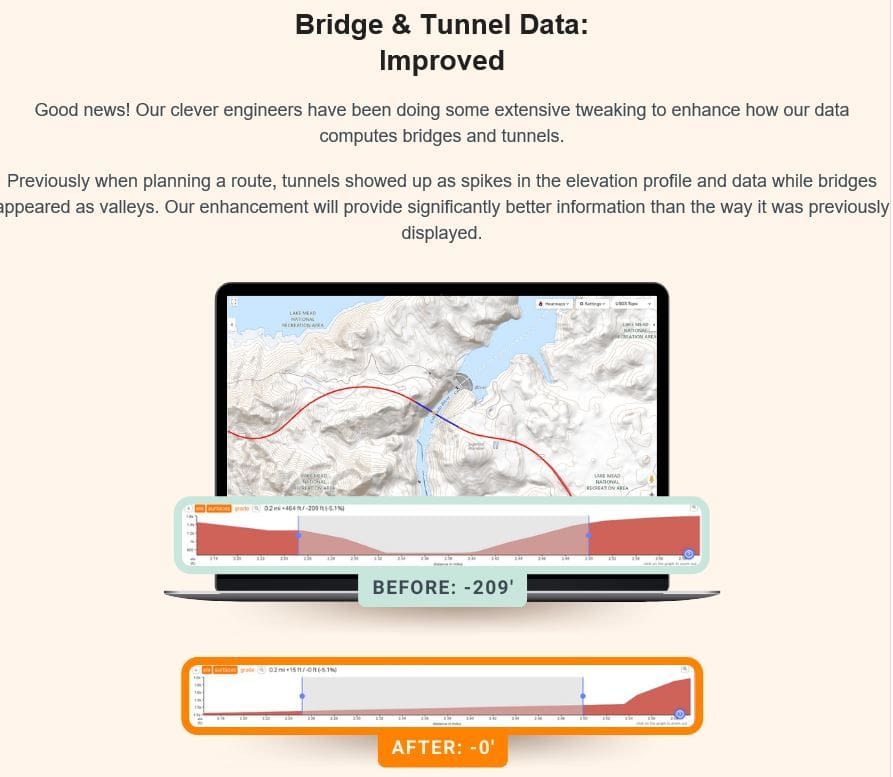
i don't pay much attention, my daily go-to ride varies from 1300 to 1700 feet depending on who i look at, and most rides are in that same 20% variance range. the only thing that annoys me consistently is that during route planning RwGPS has some really egregious errors in it's interpretation of the basemap. for example, it believes that if you ride across the golden gate bridge you instantly drop to sea level and then climb instantly back up on the other side of the straight. completely understandable - they're using the "ground" rather than the structure, which may not register in their basemap, but for a road crossed by thousands of cyclists a day every day for decades, an odd error. tunnels are similar - the route plan shows you climbing the hill OVER the tunnel a lot of the time!
strava's explanation on the subject shows some of the complexity here. crappy GPS sensors (and the nature of GPS), varying basemaps, devices with and without barometric altimeters, changing weather...
https://support.strava.com/hc/en-us/...-Your-Activity
i don't pay much attention, my daily go-to ride varies from 1300 to 1700 feet depending on who i look at, and most rides are in that same 20% variance range. the only thing that annoys me consistently is that during route planning RwGPS has some really egregious errors in it's interpretation of the basemap. for example, it believes that if you ride across the golden gate bridge you instantly drop to sea level and then climb instantly back up on the other side of the straight. completely understandable - they're using the "ground" rather than the structure, which may not register in their basemap, but for a road crossed by thousands of cyclists a day every day for decades, an odd error. tunnels are similar - the route plan shows you climbing the hill OVER the tunnel a lot of the time!
11-20-21, 12:54 PM
#41
Senior Member
Join Date: Sep 2007
Location: Far beyond the pale horizon.
Posts: 14,254
Mentioned: 31 Post(s)
Tagged: 0 Thread(s)
Quoted: 4242 Post(s)
Liked 1,342 Times
in
931 Posts
the only thing that annoys me consistently is that during route planning RwGPS has some really egregious errors in it's interpretation of the basemap. for example, it believes that if you ride across the golden gate bridge you instantly drop to sea level and then climb instantly back up on the other side of the straight. completely understandable - they're using the "ground" rather than the structure, which may not register in their basemap, but for a road crossed by thousands of cyclists a day every day for decades, an odd error. tunnels are similar - the route plan shows you climbing the hill OVER the tunnel a lot of the time!
The maps that RWGPS uses (generally, Google or Openstreetmap) don't have elevation data at all.
RWGPS use a separate map for elevation using data that eveybod has access to (RWGPS isn't collecting elevation data itself**). That map just has elevation for the surface of the earth. It doesn't include profiles for things like bridges and buildings. The data was acquired on a space shuttle mission (among other spacy sources). So, roads in tunnels wouldn't be seen at all.
RWGPS isn't "making egregious errors in its interpretation". It's just using data that is limited.
==================
** Strava collects elevation data from people's uploaded rides, which they use to augment the widely-available elevation data. Give that Strava already deals with segments, it's a short step for them to deal with elevation from rides too.
Last edited by njkayaker; 11-20-21 at 01:01 PM.
11-21-21, 03:47 PM
#42
Senior Member
Join Date: May 2021
Location: San Francisco
Posts: 2,028
Bikes: addict, aethos, creo, vanmoof, sirrus, public ...
Mentioned: 2 Post(s)
Tagged: 0 Thread(s)
Quoted: 1272 Post(s)
Liked 1,382 Times
in
707 Posts
i just noticed that RwGPS actually has a tool to correct for these errors in route plans:
https://ridewithgps.com/help/flatten-elevation
11-21-21, 04:24 PM
#43
Senior Member
Join Date: Sep 2007
Location: Far beyond the pale horizon.
Posts: 14,254
Mentioned: 31 Post(s)
Tagged: 0 Thread(s)
Quoted: 4242 Post(s)
Liked 1,342 Times
in
931 Posts
More people here might be more familiar with that map on the Garmin. Not many are going to be familiar with the GIS usage of the term.
https://www.gislounge.com/basemaps-defined/
RWGPS uses either Google or OSM (or some other) as "basemap" (it's not one). RWGPS calls them maps. RWGPS uses a DEM map to add, as a second step, elevation to routes.
i just noticed that RwGPS actually has a tool to correct for these errors in route plans:
https://ridewithgps.com/help/flatten-elevation
i just noticed that RwGPS actually has a tool to correct for these errors in route plans:
https://ridewithgps.com/help/flatten-elevation
Last edited by njkayaker; 11-21-21 at 04:41 PM.
11-21-21, 07:42 PM
#44
Senior Member
Join Date: May 2021
Location: San Francisco
Posts: 2,028
Bikes: addict, aethos, creo, vanmoof, sirrus, public ...
Mentioned: 2 Post(s)
Tagged: 0 Thread(s)
Quoted: 1272 Post(s)
Liked 1,382 Times
in
707 Posts
yeah - annoying to have to do it over and over for different routes. ideally they�d have their own layer of �corrections� over the DEM data, with some streamlined process to accept or vet them from either user data or better elevational sources, e.g. many cities have openly available topographic data, sometimes for the entire city, usually for intersections, etc. there are too many roads in the world to expect perfection with this� but the golden gate bridge !?!
11-21-21, 08:47 PM
#45
Senior Member
Join Date: Jan 2020
Posts: 2,346
Mentioned: 2 Post(s)
Tagged: 0 Thread(s)
Quoted: 680 Post(s)
Liked 947 Times
in
554 Posts
I've found all of my Garmins (500,510,810,Oregon) to provide woeful elevation data. My wife and I ride a tandem with two Garmins with the exact same settings. Though our mileage is generally pretty close, the elevation data can be as much as 25-35% different.
Also, I'm a retired highway engineer and had access to plans for numerous miles of roadway which I use to check for grade data on my rides. The grade info on the Garmins is ridiculously inaccurate while riding; it's not even the same ballpark as reality.
Also, I'm a retired highway engineer and had access to plans for numerous miles of roadway which I use to check for grade data on my rides. The grade info on the Garmins is ridiculously inaccurate while riding; it's not even the same ballpark as reality.
11-21-21, 09:17 PM
#46
Senior Member
Join Date: Mar 2010
Location: Seattle, WA
Posts: 23,208
Mentioned: 89 Post(s)
Tagged: 0 Thread(s)
Quoted: 18883 Post(s)
Liked 10,646 Times
in
6,054 Posts
yeah - annoying to have to do it over and over for different routes. ideally they�d have their own layer of �corrections� over the DEM data, with some streamlined process to accept or vet them from either user data or better elevational sources, e.g. many cities have openly available topographic data, sometimes for the entire city, usually for intersections, etc. there are too many roads in the world to expect perfection with this� but the golden gate bridge !?!
Do you know how to use a barometer to estimate the height of a tall building? You can drop it from the roof, count how many seconds until it hits the ground, and then math it out. 🙂
01-13-22, 10:40 AM
#48
Senior Member
Join Date: May 2021
Location: San Francisco
Posts: 2,028
Bikes: addict, aethos, creo, vanmoof, sirrus, public ...
Mentioned: 2 Post(s)
Tagged: 0 Thread(s)
Quoted: 1272 Post(s)
Liked 1,382 Times
in
707 Posts
good to see that RwGPS has fixed this for route planning. i noticed it a few days or a week ago.