


D&L Trail South of Easton is a Mess
 03-05-22, 04:08 PM
#26
Senior Member
Thread Starter
Join Date: Jan 2010
Posts: 39,229
Mentioned: 211 Post(s)
Tagged: 1 Thread(s)
Quoted: 18409 Post(s)
Liked 15,518 Times
in
7,324 Posts
Sounds like Jim Thorpe and White Haven could definitely suffer an economic blow.
I started going up there in ‘93. You could ride to White Haven and back and encounter very few riders. The only developed parking at Glenn Onoko was that area right by the trail head. Even the municipal lot in JT was much smaller. And the connection from that lot to GO didn’t officially exist, although you could walk over the old Jersey Central bridge (uncovered bridge timbers) and ride along the right of way to get to and from the GO trail head. Things are a lot different now.
I started going up there in ‘93. You could ride to White Haven and back and encounter very few riders. The only developed parking at Glenn Onoko was that area right by the trail head. Even the municipal lot in JT was much smaller. And the connection from that lot to GO didn’t officially exist, although you could walk over the old Jersey Central bridge (uncovered bridge timbers) and ride along the right of way to get to and from the GO trail head. Things are a lot different now.
 03-05-22, 09:29 PM
#27
I think I know nothing.
Join Date: Aug 2004
Location: NE PA
Posts: 709
Mentioned: 6 Post(s)
Tagged: 0 Thread(s)
Quoted: 233 Post(s)
Liked 290 Times
in
204 Posts
Sounds like Jim Thorpe and White Haven could definitely suffer an economic blow.
I started going up there in ‘93. You could ride to White Haven and back and encounter very few riders. The only developed parking at Glenn Onoko was that area right by the trail head. Even the municipal lot in JT was much smaller. And the connection from that lot to GO didn’t officially exist, although you could walk over the old Jersey Central bridge (uncovered bridge timbers) and ride along the right of way to get to and from the GO trail head. Things are a lot different now.
I started going up there in ‘93. You could ride to White Haven and back and encounter very few riders. The only developed parking at Glenn Onoko was that area right by the trail head. Even the municipal lot in JT was much smaller. And the connection from that lot to GO didn’t officially exist, although you could walk over the old Jersey Central bridge (uncovered bridge timbers) and ride along the right of way to get to and from the GO trail head. Things are a lot different now.
So the 1 or 2 miles of trail from the JT waste water treatment plant to the other side of the CNJ bridge in the Gorge costs about 7-8 million dollars. The whole idea was to encourage people to come and spend their vacation dollars as Carbon and Luzerne counties are on a low budget and not that many jobs. My wife and I commute 45 miles each way to Phillipsburg, NJ. It is nice where we live, some parts of the Anthrocite region are gritty but we are is a nice area but economically challenged.
From a point roughly at the northern end of the county parking lot in JT to While Haven is a state park the Lehigh Gorge, 24 miles. Continuing on, a half mile through the town of White Haven on the street then back on DCNR property at the White Haven North trail head. The next two miles is really rough and that is supposed to be fixed now. Once you get to Middleburg Rd you cross the RR track using the simple crossing that took 3 and a half years to complete, then you get on PA Forestry land for the remaining 8 miles or so to the end of the trail at Black Diamond.
About 2 miles past Middleburg Rd the trail crosses the RR at a deep cut in the rocks, you cross using what is called the "recycled bridge". The beams were salvaged from an old state road overpass. This is a very impressive bridge, very scenic and I'm sure expensive, as in a millions of bux. That bridge was built 12 years ago, the entire Black Diamond section is really nice except the first two miles but until the RR crossing at Middleburg Rd was finished it was not that easy to access.
There are two or three vendors that rent bikes and shuttle trail users plus the Scenic RR runs trains with special cars to shuttle people that want to ride the train one way and ride bikes back to where they start. Also there are a number of vendors that rent rafts and guided raft trips as the rives is i think classified as a class 3 whitewater river. All of this is shut down now due to the alleged work being done on this part of the trail, bicycle rentals and rafting. What is amazing is we just completed two years of shut downs and businesses closed left and right and we lost the second biggest employer in the county (KME Firetrucks) and here comes PA DCNR to the rescue, doing their best to finish off the remaining businesses and basically shut down a hefty part of the tourists industry until sometime mid summer (ha ha). If it were not for the fact that we have been bludgeoned to a pulp and therefore too weak to act, there would be howling in the streets over this extended and largely unnecessary and expensive trail closure.
Well in my opinion, the whole concept of basing the local economy on outdoor recreation is a bad idea but the elected officials have decided to forge ahead with this. The D&L is billed as the centerpiece of the whole historical recreation industry. I use the trail, like the trail and happy it is here but from a taxpayers point of view the trail as configured is way too expensive. Spending the money to get the trail on the west bank of the Lehigh river through the Carbon County parking lot was an expensive thing but this route was chosen to put trail users in a position to spend money in JT. Only the government will spend 10 dollars to generate 1 dollar of business.
I'm sure everyone is getting sick of hearing me rant over this but when taken as a whole, the D&L Trail itself is a huge waste of money and the D&L Heritage Corridor LLC is comprised of a large number of dysfunctional people living in an alternate universe which doesn't have what is commonly known as a grip on reality.
Last edited by Thomas15; 03-05-22 at 09:38 PM.
03-06-22, 10:02 AM
#28
I think I know nothing.
Join Date: Aug 2004
Location: NE PA
Posts: 709
Mentioned: 6 Post(s)
Tagged: 0 Thread(s)
Quoted: 233 Post(s)
Liked 290 Times
in
204 Posts
A good argument could be made that the American Industrial Revolution had it's actual beginning at the Lehigh Canal lock #1 in 1820. It is right here that the Mansion House Bridge carries the D&L Trail from the east bank to the west bank of the Lehigh River in Jim Thorpe. A good portion of that lock is still extant as are the (underwater) foundations of the wing dams that created the slackwater needed to guide the canal boats full of coal from river to canal. Preserving the ruins is, I believe, a good idea.
When the bridge was constructed it sat idle for a year after being completed because they found out that they needed another million dollars to construct a connector in the area of the waste water plant to the actual bridge, 950 feet. This situation made the Carbon Commissioners and those of us in the county look like a bunch of fools because the Heritage Corridor was all over the media patting themselves on the back over this wonderful but expensive and closed bridge.
Since I live about 5 miles from this bridge I had the opportunity to view the site on many occasions. The 950 foot connector, which cost as stated an additional million dollars is way overkill for the task. In my opinion, the EPA wanted the connector as constructed to protect the waste water plant from floods but you will not find one thing in print on this. If I'm correct on this it would make sense because the boro could never come up with that kind of money to protect the plant, which was right at that time being rebuilt at several millions of tax funded dollars and a contentious issue locally.
Here is a blog link to a story posted during construction of the connector:
https://delawareandlehigh.org/blog/u...strian-bridge/
Here is an informational a blog from the Heritage Corridor from a few years ago regarding one of the businesses that is now shut down because of the trail closures imposed by PA DCNR:
https://delawareandlehigh.org/blog/t...pocono-biking/
Last edited by Thomas15; 03-06-22 at 10:07 AM.
04-22-22, 08:08 AM
#29
Full Member
Join Date: Feb 2014
Location: Lehigh Valley
Posts: 247
Mentioned: 0 Post(s)
Tagged: 0 Thread(s)
Quoted: 122 Post(s)
Liked 53 Times
in
43 Posts
According to the recent "State of the Trail" address, the Delaware Canal portion of the D&L south of Easton is expected to be another year and a half to be repaired. The Q&A transcript is linked here:
https://delawareandlehigh.org/wp-con...2022/04/QA.pdf
https://delawareandlehigh.org/wp-con...2022/04/QA.pdf
Last edited by force10; 04-22-22 at 08:09 AM. Reason: clarification
05-06-22, 06:30 AM
#30
I think I know nothing.
Join Date: Aug 2004
Location: NE PA
Posts: 709
Mentioned: 6 Post(s)
Tagged: 0 Thread(s)
Quoted: 233 Post(s)
Liked 290 Times
in
204 Posts
According to the recent "State of the Trail" address, the Delaware Canal portion of the D&L south of Easton is expected to be another year and a half to be repaired. The Q&A transcript is linked here:
https://delawareandlehigh.org/wp-con...2022/04/QA.pdf
https://delawareandlehigh.org/wp-con...2022/04/QA.pdf
Regarding the Anthracite section...
Back in October 2020 the Heritage Corridor did a series of podcasts on the various sections of the trail and projects to complete it.
A few thigs to note on the Anthracite section. I had mentioned the Middleburg road crossing which was opened I think late August 2021 then closed a few weeks later due to construction in the Gorge. The D&L spokesperson in the podcast (Oct 2020) put the blame for the crossing delays on the RR which I think was a bad idea. They mentioned for example the crossing gate arms not being installed which is not true I have pictures of the arms installed going back to 2018. In my opinion the RR spent a ton of money as a good will gesture on this project which seems to be not appreciated by the D&L LLC. Reason: The D&L LLC cannot admit to broken promises to the local towns and businesses and is unable to communicate effectively with PA DCNR or Forestry. The D&L spokesperson in that podcast left the organization about a week later. Nothing unusual about that the D&L burns through paid staff like water over a dam and likes to replace them with people with cool college degrees and little practical experience or local knowledge.
There is an organization called the North Branch Land Trust that owns a bunch of property that will be used to connect a hairpin trail from 7 Tubbs State Park to Wilkes Barre with 7 Tubbs at the apex. The idea is to connect the southern leg of this hairpin to the existing D&L Trail. Good idea but the biggest problem is a RR crossing and highway in Oliver Mills. By tying themselves to the North Branch project will require a bridge (with helix) over a vehicle road and a 2 track mainline RR. If this ever happens it will be like 25 years from now and at in todays bux about 10 million so let's say never. Also they want to construct a mini tunnel under another roadway to make this connection. It should be noted that any of the trail north of White Haven leaves the Lehigh River basin although the northern hairpin trail would terminate on the Schuylkill River in Wilkes Barre. This connection is how they intend to get the last northern 20 miles so they can say the D&L is 165 miles long.
The story about East Penn Twp working on a connector to the SRT is interesting. I have not heard one thing about this previous. The SRT itself is in Schuylkill County, in that area it is just a patchwork of trails. East Penn (in Carbon County) has done a terrific job on the D&L in the Township, but it is difficult to envision a connector all the way to the SRT. I would think off my head this would be 20-25 miles in the northern shadow of the Blue Mountain.
a few interesting links:
North Branch Land Trust https://nblt.org/
Anthracite Scenic Trails Assoc ASTA
Happy Trails!!!
Last edited by Thomas15; 05-06-22 at 06:45 AM.
05-26-22, 08:51 AM
#31
I think I know nothing.
Join Date: Aug 2004
Location: NE PA
Posts: 709
Mentioned: 6 Post(s)
Tagged: 0 Thread(s)
Quoted: 233 Post(s)
Liked 290 Times
in
204 Posts
TRAIL UPDATE!!!
As a review in post #7, I mentioned the "Rule of 1.5" which I have identified as a more reliable indicator of when projects on the D&L Trail are completed and final cost to the tax payer. As the rule applies to the Anthracite section specifically to the trail closure from Tannery to Middleburg Rd the original plan was to close the trail in September 2021 and reopen in Spring 2022. The date has been tweeked a few times but seemed to settle down at May 2022. Looking at the calendar on the wall I see that it is end of May. Then in late December 2021, the more vague completion timeframe of "Summer 2022" was put out there for public consumption and vacation/recreation planning purposes.
In my post #21, I made the bold prediction that it would actually be around labor day before the trail (and outfitters relying of the trail for business) would be granted the opportunity to use the thing. I came to this based on the Rule of 1.5.
I have to confess that I was a bit worried that having made my public prediction of a Labor Day trail opening and my reliance on the "Rule of 1.5" to determine dates and stuff might be inaccurate this time around but to the rescue PA DCNR has thus saved my bacon.
It is now official the section of the D&L from Lehigh Tannery to Middleburg Rd will be closed until the Fall of 2022. The Rule of 1.5 continues to be an accurate predictor of trail closure timeframes.
Oh well it could be worse, if PA didn't have as the governor likes to say "Government that Works" the trail would be nothing but dirt. Which for all intents and purposes it is dirt and will be always be dirt but there is dirt and there is dirt dirt.
https://delawareandlehigh.org/map/tr...ehigh-tannery/
06-13-22, 05:31 AM
#32
Rider who can know more

Join Date: Aug 2015
Location: Lehigh Valley
Posts: 106
Bikes: 1995 Trek 850 Mountain Track turned trail and road bike, 1989 Centurion Le Mans RS, 1993 Bianchi Advantage. Dead: 1982 Schwinn Traveler
Mentioned: 0 Post(s)
Tagged: 0 Thread(s)
Quoted: 46 Post(s)
Liked 8 Times
in
6 Posts
So you ride over the Free Bridge, head up Main St, hand a left on Carpentersville rd, and then hug the riverside roads down to Milford?
06-13-22, 05:42 AM
#33
Senior Member
Join Date: Apr 2021
Posts: 4,083
Mentioned: 6 Post(s)
Tagged: 0 Thread(s)
Quoted: 2333 Post(s)
Liked 2,097 Times
in
1,314 Posts
Yes. I would call it down Main Street (down river or make a right after crossing and I think walking on the bridge is required by the bridge police.). There is a small option around Rieegelsville to take the old road or the new one along the river for a while but it is basically follow river road which becomes 627 IIRC
06-13-22, 05:51 AM
#34
Rider who can know more
Join Date: Aug 2015
Location: Lehigh Valley
Posts: 106
Bikes: 1995 Trek 850 Mountain Track turned trail and road bike, 1989 Centurion Le Mans RS, 1993 Bianchi Advantage. Dead: 1982 Schwinn Traveler
Mentioned: 0 Post(s)
Tagged: 0 Thread(s)
Quoted: 46 Post(s)
Liked 8 Times
in
6 Posts
Fair. I think up because you hang the right and head uphill.
06-13-22, 07:31 AM
#35
Full Member
Join Date: Feb 2014
Location: Lehigh Valley
Posts: 247
Mentioned: 0 Post(s)
Tagged: 0 Thread(s)
Quoted: 122 Post(s)
Liked 53 Times
in
43 Posts
You are required to walk across the Free Bridge. And a lot of cyclists will jog off onto Mercer st going through P-burg for a bit quieter stretch. And the turn onto Carpentersville is a right just after the RR overpass (be ready with the small chainring).
As Ghostrider mentions, after you pass the Riegelsville Bridge, you can either take Riegelsville/Milford Rd all the way or go along the Old River Rd for a short while. Old River Rd is prettier with some cool houses and small farms and river views, and avoids a very small hill; but the pavement is pretty crummy and if the river has flooded recently it could be quite muddy back there too.
Likes For force10:
06-13-22, 07:41 AM
#36
Rider who can know more
Join Date: Aug 2015
Location: Lehigh Valley
Posts: 106
Bikes: 1995 Trek 850 Mountain Track turned trail and road bike, 1989 Centurion Le Mans RS, 1993 Bianchi Advantage. Dead: 1982 Schwinn Traveler
Mentioned: 0 Post(s)
Tagged: 0 Thread(s)
Quoted: 46 Post(s)
Liked 8 Times
in
6 Posts
06-13-22, 01:22 PM
#37
Senior Member
Thread Starter
Join Date: Jan 2010
Posts: 39,229
Mentioned: 211 Post(s)
Tagged: 1 Thread(s)
Quoted: 18409 Post(s)
Liked 15,518 Times
in
7,324 Posts
The roads between P’Burg and Milford are.really nice.
I was up that way last year training for a tour. Stopped to use the porta potty at the boat launch on Old River Rd. Stopped there again during the trout which gave rise to this thread to find the porta potty smashed into pieces from the flood, and there was a kayak lodged between a split in a tree.
I was up that way last year training for a tour. Stopped to use the porta potty at the boat launch on Old River Rd. Stopped there again during the trout which gave rise to this thread to find the porta potty smashed into pieces from the flood, and there was a kayak lodged between a split in a tree.
07-08-22, 09:31 AM
#38
Rider who can know more
Join Date: Aug 2015
Location: Lehigh Valley
Posts: 106
Bikes: 1995 Trek 850 Mountain Track turned trail and road bike, 1989 Centurion Le Mans RS, 1993 Bianchi Advantage. Dead: 1982 Schwinn Traveler
Mentioned: 0 Post(s)
Tagged: 0 Thread(s)
Quoted: 46 Post(s)
Liked 8 Times
in
6 Posts
Changes afoot?
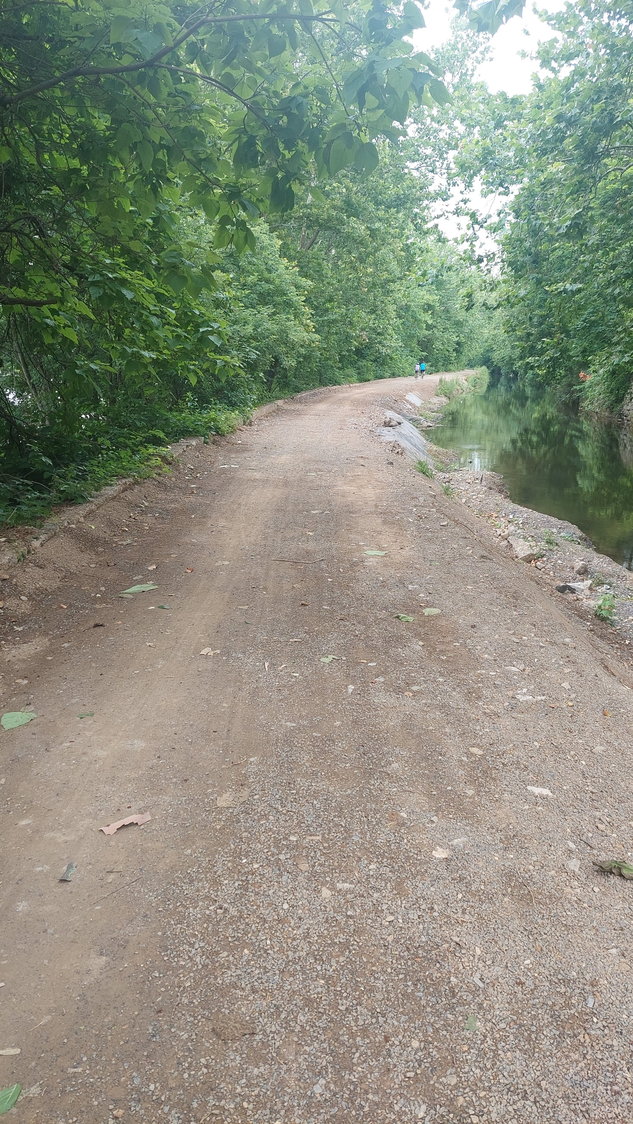
I was driving back from a hike and driving along 611 South of Easton and looked over to see if any repairs had been made to the D&L trail in that area. And it looked like work was being done since there was very visible scraping on the path.
So the next day I hitched the trail-a-bike to my bike and pitched an adventure ride to my offspring and off we went to see how much the trail was fixed. I rode south from where the Lehigh and Delaware meet and rode down to just south of Raub's Island. Other than dodging a new/old sinkhole at the spillway North of Wy-Hit-Tuk Park things in the damaged areas were improved.
Near Easton:
South of Raub's Island:

Basically it looks like some dirt was added to what was already there and then packed down and some scraping was done to roughly even things up. So the stones are covered, though rocks poke through, and most of it is missing gravel but it is rideable to more people now. It's a bit rough still and will get swampy in the rain but we have more of a trail now than we did before 1-2 weeks ago.
I only went about 6 miles so I do not know the on ground state of things further south but I hope for a similar rough return to operations for other similarly damaged areas.
So this is good but it needs finishing.
So the next day I hitched the trail-a-bike to my bike and pitched an adventure ride to my offspring and off we went to see how much the trail was fixed. I rode south from where the Lehigh and Delaware meet and rode down to just south of Raub's Island. Other than dodging a new/old sinkhole at the spillway North of Wy-Hit-Tuk Park things in the damaged areas were improved.
Near Easton:
South of Raub's Island:
Basically it looks like some dirt was added to what was already there and then packed down and some scraping was done to roughly even things up. So the stones are covered, though rocks poke through, and most of it is missing gravel but it is rideable to more people now. It's a bit rough still and will get swampy in the rain but we have more of a trail now than we did before 1-2 weeks ago.
I only went about 6 miles so I do not know the on ground state of things further south but I hope for a similar rough return to operations for other similarly damaged areas.
So this is good but it needs finishing.
07-18-22, 09:10 AM
#39
Senior Member
Thread Starter
Join Date: Jan 2010
Posts: 39,229
Mentioned: 211 Post(s)
Tagged: 1 Thread(s)
Quoted: 18409 Post(s)
Liked 15,518 Times
in
7,324 Posts
Any knowledge about the rideability south from JT to Weissport? I am planning a September tour from eastern Ohio home to Philly that has be at Muach Chunk Lake Park one night then on the trail to Northampton and then getting off, ending up in Up[per Black Eddy for the night but not via Easton. I think I recall you saying that some work had been done between JT and Weissport. I am not worried about having to get off the walk the bike in a few places, but it has to be passable.
TIA
TIA
07-31-22, 09:51 PM
#40
I think I know nothing.
Join Date: Aug 2004
Location: NE PA
Posts: 709
Mentioned: 6 Post(s)
Tagged: 0 Thread(s)
Quoted: 233 Post(s)
Liked 290 Times
in
204 Posts
Any knowledge about the rideability south from JT to Weissport? I am planning a September tour from eastern Ohio home to Philly that has be at Muach Chunk Lake Park one night then on the trail to Northampton and then getting off, ending up in Up[per Black Eddy for the night but not via Easton. I think I recall you saying that some work had been done between JT and Weissport. I am not worried about having to get off the walk the bike in a few places, but it has to be passable.
TIA
TIA
I haven't been on my bike for a while due to a medical issue. Today, first ride in months, I rode from Weissport to Penn Haven and back. Not too bad, there wasn't any construction vehicles or work being performed. There are a few short sections that have the course base stone and no fine upper layer but overall fairly decent. I'm going to ride from Lehighton to Northampton next weekend and will let you know what the situation is there.
08-01-22, 04:08 AM
#41
Newbie
Join Date: Jun 2017
Location: PA & NY
Posts: 33
Bikes: Specialized Crosstrail, Canyon Endurance AL
Mentioned: 1 Post(s)
Tagged: 0 Thread(s)
Quoted: 13 Post(s)
Likes: 0
Liked 1 Time
in
1 Post
Any knowledge about the rideability south from JT to Weissport? I am planning a September tour from eastern Ohio home to Philly that has be at Muach Chunk Lake Park one night then on the trail to Northampton and then getting off, ending up in Up[per Black Eddy for the night but not via Easton. I think I recall you saying that some work had been done between JT and Weissport. I am not worried about having to get off the walk the bike in a few places, but it has to be passable.
TIA
TIA
I'd like to note they've also made repairs to the trail north of JT to the Tannery trail head but there's one section between mile marker 112 and 114 that is still soft (like biking on the beach). They also made upgrades to the restroom facilities at the Rockport trail head, adding a new water fountain and a bike repair tool / air pump station.
From the Tannery trail head to Middleburg Rd (north of White Haven) the trail has been closed all summer for extensive trail work. From White Haven north to Middleburg Rd. might have re-opened but as of about a month ago, from the Tannery trail head to White Haven was still closed with an expected re-open time-frame of this fall.
08-01-22, 04:17 AM
#42
Senior Member
Thread Starter
Join Date: Jan 2010
Posts: 39,229
Mentioned: 211 Post(s)
Tagged: 1 Thread(s)
Quoted: 18409 Post(s)
Liked 15,518 Times
in
7,324 Posts
Thanks. Now if I can just get in good enough shape. 
08-01-22, 07:37 AM
#43
I think I know nothing.
Join Date: Aug 2004
Location: NE PA
Posts: 709
Mentioned: 6 Post(s)
Tagged: 0 Thread(s)
Quoted: 233 Post(s)
Liked 290 Times
in
204 Posts
I know how you feel!
There is by the way a local facebook group that generally keeps tabs on the D&L, mostly on the upper end but covers it all to an extent. "We Like Bikes!" public group 1.9k members. Friendly crowd.
There is by the way a local facebook group that generally keeps tabs on the D&L, mostly on the upper end but covers it all to an extent. "We Like Bikes!" public group 1.9k members. Friendly crowd.
Last edited by Thomas15; 08-01-22 at 07:49 AM.
09-09-22, 12:28 PM
#44
I think I know nothing.
Join Date: Aug 2004
Location: NE PA
Posts: 709
Mentioned: 6 Post(s)
Tagged: 0 Thread(s)
Quoted: 233 Post(s)
Liked 290 Times
in
204 Posts
The good news for today is the State of PA has deemed the Delaware Canal State Park (the D&L south of Easton) the "PA Trail of the Year 2022".
Of course a good chunk of it still has storm damage and closures and still needs a 75 million dollar transfusion which tells you what about all of the other trails in the commonwealth?
https://www.wfmz.com/news/area/south...ge-Top-Stories
Interesting that there is no mention of the "Heritage Corridor LLC" in the article.
Last edited by Thomas15; 09-09-22 at 12:42 PM.
09-09-22, 08:55 PM
#45
Senior Member
Thread Starter
Join Date: Jan 2010
Posts: 39,229
Mentioned: 211 Post(s)
Tagged: 1 Thread(s)
Quoted: 18409 Post(s)
Liked 15,518 Times
in
7,324 Posts
The good news for today is the State of PA has deemed the Delaware Canal State Park (the D&L south of Easton) the "PA Trail of the Year 2022".
Of course a good chunk of it still has storm damage and closures and still needs a 75 million dollar transfusion which tells you what about all of the other trails in the commonwealth?
https://www.wfmz.com/news/area/south...ge-Top-Stories
Interesting that there is no mention of the "Heritage Corridor LLC" in the article.
Of course a good chunk of it still has storm damage and closures and still needs a 75 million dollar transfusion which tells you what about all of the other trails in the commonwealth?
https://www.wfmz.com/news/area/south...ge-Top-Stories
Interesting that there is no mention of the "Heritage Corridor LLC" in the article.
09-21-22, 12:32 PM
#46
Senior Member
Thread Starter
Join Date: Jan 2010
Posts: 39,229
Mentioned: 211 Post(s)
Tagged: 1 Thread(s)
Quoted: 18409 Post(s)
Liked 15,518 Times
in
7,324 Posts
So...I rode from Jim Thorpe down to Northampton on Saturday. No problems. The section between JT and Weissport had a couple of sections where they put small rocks down, I assume due to the damage from Ida. No problem fully-loaded with 37c tires.
I later picked up the trail again where PA 212 ends at PA 611, just below Riegelsville. There does not appear to be any Ida damage (except as noted below), but boy does that segment suck. It's basically single track trail with grass growing all around the one track. It was like riding in a notch. I kept getting going from side to side, and it was not that smooth.
The "gap" a mile ro so above Upper Black Eddy is still there. Nothing has been done in the way of repairs. A bit before you get to it there is a way off the trail onto PA 32. But there are no trespassing signs. I wasn't sure if they were referring to the actual route out or the properties surrounding the way off. I kept going. No one confronted me.
09-22-22, 07:36 AM
#47
Full Member
Join Date: Feb 2014
Location: Lehigh Valley
Posts: 247
Mentioned: 0 Post(s)
Tagged: 0 Thread(s)
Quoted: 122 Post(s)
Liked 53 Times
in
43 Posts
This is a short survey for interested users of the Delaware Canal section of the trail - https://sites.google.com/studiobryan...032plan/survey
01-21-23, 03:57 PM
#48
Newbie
Wow, Thomas15, thanks for this thread.
I’ve been playing:biking the towpath (mostly Bethlehem-Freemansburg) since I was a kid. I was heavily into MTB riding but we did the Bethlehem to newhope ride every year about 20 years ago and Bethlehem to Regalsville often. Sorry to hear about the state of the trail south of easton.
recently started riding again and did Bethlehem to Freemansburg last week, only real surprise was the tent cities.
did northbound from Slatington this morning, about 4 miles out and that section is very nice.
anyway, thanks again for all the info. I always suspected the D&L folks might smell a little scammy.
02-03-23, 03:22 PM
#49
Junior Member
A few months ago I stumbled on a description of the D&L being 140 miles + from Bristol to Glen Summit or at least well past Jim Thorpe. I even confirmed it with TrailLink but other than some promotional material claiming its one complete trail it sure doesn't seem like its doable or "done" at all. Anyone ever ride the whole thing? detouring around D&L closures by taking the D&R maybe? hard to map around the closures via the interactive D&L map as it shows whole sections closed and little factual info about closures or how to navigate around....some mentioning thru travel but most just saying "turn around" did not seem like a rout many have done so I forgot about it.
Drove up and rode a decent chunk of the D&R from just above Trenton 30 miles towards Brunswick and back. Really nice ride, got me thinking of doing the whole D&L vs driving all the way to do the the C&O/GAP twice this summer. 20 miles north or south of Jim Thorpe looks very GAP like, that part seems perfect for a trip my wife could take with me and enjoy.
Drove up and rode a decent chunk of the D&R from just above Trenton 30 miles towards Brunswick and back. Really nice ride, got me thinking of doing the whole D&L vs driving all the way to do the the C&O/GAP twice this summer. 20 miles north or south of Jim Thorpe looks very GAP like, that part seems perfect for a trip my wife could take with me and enjoy.
02-08-23, 09:14 AM
#50
Senior Member
Thread Starter
Join Date: Jan 2010
Posts: 39,229
Mentioned: 211 Post(s)
Tagged: 1 Thread(s)
Quoted: 18409 Post(s)
Liked 15,518 Times
in
7,324 Posts
A few months ago I stumbled on a description of the D&L being 140 miles + from Bristol to Glen Summit or at least well past Jim Thorpe. I even confirmed it with TrailLink but other than some promotional material claiming its one complete trail it sure doesn't seem like its doable or "done" at all. Anyone ever ride the whole thing? detouring around D&L closures by taking the D&R maybe? hard to map around the closures via the interactive D&L map as it shows whole sections closed and little factual info about closures or how to navigate around....some mentioning thru travel but most just saying "turn around" did not seem like a rout many have done so I forgot about it.
Drove up and rode a decent chunk of the D&R from just above Trenton 30 miles towards Brunswick and back. Really nice ride, got me thinking of doing the whole D&L vs driving all the way to do the the C&O/GAP twice this summer. 20 miles north or south of Jim Thorpe looks very GAP like, that part seems perfect for a trip my wife could take with me and enjoy.
Drove up and rode a decent chunk of the D&R from just above Trenton 30 miles towards Brunswick and back. Really nice ride, got me thinking of doing the whole D&L vs driving all the way to do the the C&O/GAP twice this summer. 20 miles north or south of Jim Thorpe looks very GAP like, that part seems perfect for a trip my wife could take with me and enjoy.
https://delawareandlehigh.org/map/
The map sections describe conditions. There was a good amount of hurricane damage in places two years ago. Ask me how I know.
Likes For indyfabz: