


Blazing a New Route - How Would YOU Do It?
 10-23-21, 05:00 AM
#26

2-Wheeled Fool
Thread Starter

Join Date: Sep 2016
Location: New Hampshire
Posts: 2,346
Bikes: Surly Ogre, Brompton
Mentioned: 18 Post(s)
Tagged: 0 Thread(s)
Quoted: 1385 Post(s)
Liked 677 Times
in
457 Posts
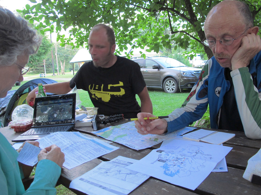
Probably not very helpful, but... I thought your original comment about starting with paper first seemed daft, but after reading about what the logistics and locale are it makes a lot more sense. I can see where starting with the DeLorme Atlas & Gazetteer and entering the route into some digital tool makes a lot of sense. I doubt folks use the Gazetteer too much these days, but they still are a great tool for some uses. Back in the day I used them a lot for all kinds of outdoor pursuits.

I like that you said, "Back in the day I used them a lot for all kinds of outdoor pursuits." I remember being at camp and there'd be my brother in law, Pete, his boys, Me, and my boy, all sitting around the woodstove looking at Maine atlases. "Hey! Is that a stream, I see right there?" or, "That looks like a ridge. Is there another way to get to the water from that spot?" I've spent hours and hours staring at topo maps and DeLorme atlases. Its been feeling like old times again!
Maybe something can be said about preserving the old map-reading skills? Hedging against the digital age?
I just bought a new atlas for NH. They've combined NH with VT, which is actually pretty nice. We spend most of our recreational time in ether ME, NH, or VT, so one less atlas is a good thing, right? When I got the new NH atlas, I instantly started tracing out a route that starts here in NH, but when I got to the ME atlas, I could instantly tell that I would need to purchase a new version of the ME atlas because the maps looked completely different from each other in terms of ease of use. The ME atlas I have is about 20 years old. I ordered a new one.
 10-23-21, 05:38 AM
#27
Hooked on Touring
What I miss?
Three or four cyclists sitting around a big table at Ernie's Birchwood Hostel in Missoula
poring over a map folded out all the way - taking up the entire tabletop.
Nowadays, it seems everyone is looking at their own phone screen.
Yes, you can discuss your options - as we do here on the forum,
but the shared activity - the physical, tactile portion is missing.
But wait, there's more -
Althought you can scroll and zoom in and out on a phone screen,
it is difficult to get the larger view - the whole tabletop.
Kinda like having to switch from the New Hampshire to the Maine atlas.
Was it also at Ernie's where he used two DeLorme Montana atlases -
And posted the entire state on the wall? So very low-tech.
But quite "big picture" in a way that phone screens simply can't do.
Technology does change the way we organize our thinking.
My formal writing is much more stream-of-consciousness nowadays.
I can toss out all my ideas on a screen - then arrange and edit later.
You couldn't do that with a typewriter - even with Correcta-Ribbon.
So - a final thought -
When enmeshed in the all the details that technology allows you,
keep in mind the larger picture.
10-23-21, 05:50 AM
#28
2-Wheeled Fool
Thread Starter
Join Date: Sep 2016
Location: New Hampshire
Posts: 2,346
Bikes: Surly Ogre, Brompton
Mentioned: 18 Post(s)
Tagged: 0 Thread(s)
Quoted: 1385 Post(s)
Liked 677 Times
in
457 Posts
What I miss?
Three or four cyclists sitting around a big table at Ernie's Birchwood Hostel in Missoula
poring over a map folded out all the way - taking up the entire tabletop.
Nowadays, it seems everyone is looking at their own phone screen.
Yes, you can discuss your options - as we do here on the forum,
but the shared activity - the physical, tactile portion is missing.
But wait, there's more -
Althought you can scroll and zoom in and out on a phone screen,
it is difficult to get the larger view - the whole tabletop.
Kinda like having to switch from the New Hampshire to the Maine atlas.
Was it also at Ernie's where he used two DeLorme Montana atlases -
And posted the entire state on the wall? So very low-tech.
But quite "big picture" in a way that phone screens simply can't do.
Technology does change the way we organize our thinking.
My formal writing is much more stream-of-consciousness nowadays.
I can toss out all my ideas on a screen - then arrange and edit later.
You couldn't do that with a typewriter - even with Correcta-Ribbon.
So - a final thought -
When enmeshed in the all the details that technology allows you,
keep in mind the larger picture.
Three or four cyclists sitting around a big table at Ernie's Birchwood Hostel in Missoula
poring over a map folded out all the way - taking up the entire tabletop.
Nowadays, it seems everyone is looking at their own phone screen.
Yes, you can discuss your options - as we do here on the forum,
but the shared activity - the physical, tactile portion is missing.
But wait, there's more -
Althought you can scroll and zoom in and out on a phone screen,
it is difficult to get the larger view - the whole tabletop.
Kinda like having to switch from the New Hampshire to the Maine atlas.
Was it also at Ernie's where he used two DeLorme Montana atlases -
And posted the entire state on the wall? So very low-tech.
But quite "big picture" in a way that phone screens simply can't do.
Technology does change the way we organize our thinking.
My formal writing is much more stream-of-consciousness nowadays.
I can toss out all my ideas on a screen - then arrange and edit later.
You couldn't do that with a typewriter - even with Correcta-Ribbon.
So - a final thought -
When enmeshed in the all the details that technology allows you,
keep in mind the larger picture.
I also respect that you have used the correct spelling for the word, "poring". Many people don't. Well played!
Last edited by J.Higgins; 10-23-21 at 05:54 AM. Reason: cuz I wanna!
10-23-21, 06:03 AM
#29
Senior Member
Join Date: Sep 2013
Location: Spain
Posts: 1,063
Mentioned: 4 Post(s)
Tagged: 0 Thread(s)
Quoted: 271 Post(s)
Liked 487 Times
in
236 Posts
Be flexible. Definitely. NOTHING I do ever comes out like it did when planning it in my head. Nothing!
Many have said they don't use paper maps, but I don't think it would be wise to leave them on my initial trip. My plan is to map a challenging trail that other people would like to ride when I'm done. Where I'm headed its a bjillion acres of wooded BFE nothingness. Nothing but trees and water (pronounced watta up heah). So a wrong turn could easily cost me the progress made in a day. I'm not afraid of failure at all, but I do work with a sense of urgency and purpose, and I must be precise. Can't help it. So using my paper maps will be necessary for this grouchy old throwback. My old business partner is still bugging me to come out of retirement. If he's successful, meaning if he lobs enough money at me, I might not be taking this trip at all.
Question to you, Stu: What GPS should I get now? I have a Wahoo Element, which is satisfactory for normal riding, but its map features kinda suck. Should I just break down and buy a nice handheld GPS?
Also just a note to anyone interested - I would love to have a partner for this. Holler if you got some time next summer, late August into September timeframe.
10-23-21, 06:28 AM
#30
Senior Member
What I miss?
Three or four cyclists sitting around a big table at Ernie's Birchwood Hostel in Missoula
poring over a map folded out all the way - taking up the entire tabletop.
Nowadays, it seems everyone is looking at their own phone screen.
Yes, you can discuss your options - as we do here on the forum,
but the shared activity - the physical, tactile portion is missing.
But wait, there's more -
Althought you can scroll and zoom in and out on a phone screen,
it is difficult to get the larger view - the whole tabletop.
Kinda like having to switch from the New Hampshire to the Maine atlas.
Was it also at Ernie's where he used two DeLorme Montana atlases -
And posted the entire state on the wall? So very low-tech.
But quite "big picture" in a way that phone screens simply can't do.
Technology does change the way we organize our thinking.
My formal writing is much more stream-of-consciousness nowadays.
I can toss out all my ideas on a screen - then arrange and edit later.
You couldn't do that with a typewriter - even with Correcta-Ribbon.
So - a final thought -
When enmeshed in the all the details that technology allows you,
keep in mind the larger picture.
Three or four cyclists sitting around a big table at Ernie's Birchwood Hostel in Missoula
poring over a map folded out all the way - taking up the entire tabletop.
Nowadays, it seems everyone is looking at their own phone screen.
Yes, you can discuss your options - as we do here on the forum,
but the shared activity - the physical, tactile portion is missing.
But wait, there's more -
Althought you can scroll and zoom in and out on a phone screen,
it is difficult to get the larger view - the whole tabletop.
Kinda like having to switch from the New Hampshire to the Maine atlas.
Was it also at Ernie's where he used two DeLorme Montana atlases -
And posted the entire state on the wall? So very low-tech.
But quite "big picture" in a way that phone screens simply can't do.
Technology does change the way we organize our thinking.
My formal writing is much more stream-of-consciousness nowadays.
I can toss out all my ideas on a screen - then arrange and edit later.
You couldn't do that with a typewriter - even with Correcta-Ribbon.
So - a final thought -
When enmeshed in the all the details that technology allows you,
keep in mind the larger picture.
10-23-21, 07:51 AM
#31
Senior Member
Join Date: Jul 2007
Location: South shore, L.I., NY
Posts: 6,856
Bikes: Flyxii FR322, Cannondale Topstone, Miyata City Liner, Specialized Chisel, Specialized Epic Evo
Mentioned: 18 Post(s)
Tagged: 0 Thread(s)
Quoted: 3221 Post(s)
Liked 2,043 Times
in
1,169 Posts
That link may not be good. His YT handle is GrayBeard Nomad
Also Chris Shontz's channel, venture4wd, he did a trip thru here a few years back. Unfortunately Chris's system has you pay if you want the GPS track and he is always cadgy as to where he happens to be, as in, he never describes or mentions whatever lake he's at.
Last edited by Steve B.; 10-23-21 at 08:21 AM.
10-23-21, 08:24 AM
#32
Full Member
Basically, I use Osmand for the maps, plot a route, save as a gpx file and send it to the gps unit.
Osmand has many advantages such as being able to mark off my own favourites as well as displaying a range of POIs. Best of all it works completely offline.
The disadvantages are that it's a bit clunky to learn and it depends on users to update the base info that comes from OpenStreetMaps.
Wahoo used to be set up that any new route loaded into their app had to "ping" off their server (requiring being online) but that has changed now so it works totally offline.
Being able to use an "outside" app like Osmand has really boosted the usability and usefulness of the Elemnt or Bolt.
Good luck
Likes For HobbesOnTour:
10-23-21, 08:25 AM
#33
Full Member
Basically, I use Osmand for the maps, plot a route, save as a gpx file and send it to the gps unit.
Osmand has many advantages such as being able to mark off my own favourites as well as displaying a range of POIs. Best of all it works completely offline.
The disadvantages are that it's a bit clunky to learn and it depends on users to update the base info that comes from OpenStreetMaps.
Wahoo used to be set up that any new route loaded into their app had to "ping" off their server (requiring being online) but that has changed now so it works totally offline.
Being able to use an "outside" app like Osmand has really boosted the usability and usefulness of the Elemnt or Bolt.
Good luck
10-23-21, 08:38 AM
#34
Senior Member
Join Date: Apr 2021
Posts: 4,083
Mentioned: 6 Post(s)
Tagged: 0 Thread(s)
Quoted: 2332 Post(s)
Liked 2,097 Times
in
1,314 Posts
I planned to ride from San Diego to Florida when Covid hit. There were parts of the Southern Tier route that I did not want to ride and it is often that way for me. So, one of the resources I look for is whether that section has had RUSA brevets on it. If so, I will tend to take the routes that they select over myself randomly picking something connect the dots on RWGPS. On Strava, you can look at heatmaps in more urban areas. You can also look to state routes or guidance. As a last resort, I look at the roads on Google maps using street view. Narrow, busy roads with no shoulder or with rumble strips get the axe.
10-23-21, 08:41 AM
#35
Senior Member
was even going to follow up with a , " I prefer doing the Buddhist monk pilgrimage prone on your hands and knees, slide knees along wooden knee pads, repeat" thing, to get an even better feel for the surface (first saw this reading some crazy guy blogs of touring in Nepal I think, some people actually do this, for hundreds and thousands of kms, yowzer!
10-23-21, 09:06 AM
#36
Palmer

Join Date: Mar 2007
Location: Parts Unknown
Posts: 8,599
Bikes: Mike Melton custom, Alex Moulton AM, Dahon Curl
Mentioned: 37 Post(s)
Tagged: 0 Thread(s)
Quoted: 1657 Post(s)
Liked 1,803 Times
in
1,050 Posts
10-23-21, 10:38 AM
#37
Senior Member
10-23-21, 11:23 AM
#38
Palmer
Join Date: Mar 2007
Location: Parts Unknown
Posts: 8,599
Bikes: Mike Melton custom, Alex Moulton AM, Dahon Curl
Mentioned: 37 Post(s)
Tagged: 0 Thread(s)
Quoted: 1657 Post(s)
Liked 1,803 Times
in
1,050 Posts
What are your goals? Do you primarily want to transverse the distance and arrive at a destination...or do you primarily want to go on a journey?
There's not a right or wrong answer, but your personal answer will impact the new route you plan.
I put more emphasis on the journey. Again, that's just me; your personal preference can be very different. It's all good. Anyway, don't ask me how long it took, ask me how much time I was able to spend. With an understanding that the route starts and ends at some discrete points, has to have basic services (food, camping/motels) at reasonable intervals and avoid statistically unsafe roadways for slow, vulnerable road users, I look for:
So the question is: How would YOU do it? With given start and end points OR a region of the country in mind, I lay in one or more (depending on tour length) intermediate full-service towns. With the tour route now broken into segments, I start looking through guide books and atlases and 'guides to campgrounds' and querying Google for things that interest me in the area. Then I lay out a basic route in Ride With GPS. Next comes the rather tedious step of interrogating Google Street View & Global View to tweak the route onto as many country lanes as possible.
For an example, here's my route between Elk City, Oklahoma on Adventure Cycling's Route 66 and Bastrop, Texas on Adventure Cycling's Southern Tier:
https://ridewithgps.com/routes/36600606
There's not a right or wrong answer, but your personal answer will impact the new route you plan.
I put more emphasis on the journey. Again, that's just me; your personal preference can be very different. It's all good. Anyway, don't ask me how long it took, ask me how much time I was able to spend. With an understanding that the route starts and ends at some discrete points, has to have basic services (food, camping/motels) at reasonable intervals and avoid statistically unsafe roadways for slow, vulnerable road users, I look for:
- museums & tours (breweries, wineries, unique businesses, industrial operations, notable architecture, historic buildings & churches)
- interesting geologic formations/areas, scenic overlooks, waterfalls, etc.
- points of interest
- regionally noteworthy/famous cuisine
- quiet country lanes & good scenery
So the question is: How would YOU do it? With given start and end points OR a region of the country in mind, I lay in one or more (depending on tour length) intermediate full-service towns. With the tour route now broken into segments, I start looking through guide books and atlases and 'guides to campgrounds' and querying Google for things that interest me in the area. Then I lay out a basic route in Ride With GPS. Next comes the rather tedious step of interrogating Google Street View & Global View to tweak the route onto as many country lanes as possible.
For an example, here's my route between Elk City, Oklahoma on Adventure Cycling's Route 66 and Bastrop, Texas on Adventure Cycling's Southern Tier:
https://ridewithgps.com/routes/36600606
Likes For tcs:
10-23-21, 01:32 PM
#39
Senior Member
Lots of good advice/opinions above. For me it matters how long the route is, and how many surprises I'm willing to put up with. One drawback of most route maps is their tunnel vision, alluded to by Mr. Jam, above, if there is a tree down, accident, road construction, the route map and cue sheet are often less than helpful in figuring out a detour. If I'm planning a multiday route, places to stay, camp, eat, etc. are important.
10-23-21, 02:35 PM
#40
Senior Member
10-23-21, 11:29 PM
#41
Senior Member
Join Date: Mar 2009
Location: Oregon
Posts: 6,489
Mentioned: 31 Post(s)
Tagged: 0 Thread(s)
Quoted: 1182 Post(s)
Liked 833 Times
in
435 Posts
What I miss?
Three or four cyclists sitting around a big table at Ernie's Birchwood Hostel in Missoula
poring over a map folded out all the way - taking up the entire tabletop.
Nowadays, it seems everyone is looking at their own phone screen.
Yes, you can discuss your options - as we do here on the forum,
but the shared activity - the physical, tactile portion is missing.
But wait, there's more -
Althought you can scroll and zoom in and out on a phone screen,
it is difficult to get the larger view - the whole tabletop.
Kinda like having to switch from the New Hampshire to the Maine atlas.
Was it also at Ernie's where he used two DeLorme Montana atlases -
And posted the entire state on the wall? So very low-tech.
But quite "big picture" in a way that phone screens simply can't do.
Technology does change the way we organize our thinking.
My formal writing is much more stream-of-consciousness nowadays.
I can toss out all my ideas on a screen - then arrange and edit later.
You couldn't do that with a typewriter - even with Correcta-Ribbon.
So - a final thought -
When enmeshed in the all the details that technology allows you,
keep in mind the larger picture.
Three or four cyclists sitting around a big table at Ernie's Birchwood Hostel in Missoula
poring over a map folded out all the way - taking up the entire tabletop.
Nowadays, it seems everyone is looking at their own phone screen.
Yes, you can discuss your options - as we do here on the forum,
but the shared activity - the physical, tactile portion is missing.
But wait, there's more -
Althought you can scroll and zoom in and out on a phone screen,
it is difficult to get the larger view - the whole tabletop.
Kinda like having to switch from the New Hampshire to the Maine atlas.
Was it also at Ernie's where he used two DeLorme Montana atlases -
And posted the entire state on the wall? So very low-tech.
But quite "big picture" in a way that phone screens simply can't do.
Technology does change the way we organize our thinking.
My formal writing is much more stream-of-consciousness nowadays.
I can toss out all my ideas on a screen - then arrange and edit later.
You couldn't do that with a typewriter - even with Correcta-Ribbon.
So - a final thought -
When enmeshed in the all the details that technology allows you,
keep in mind the larger picture.
Four bike tourists, a Canadian, a German and two Americans; were sharing a campsite in Alberta, Canada. We were also sharing route information. We ended up sharing campsites for a couple of days until they got in front of us, and our routes diverged.

Last edited by Doug64; 10-24-21 at 02:19 PM.
Likes For Doug64:
10-24-21, 05:20 AM
#42
2-Wheeled Fool
Thread Starter
Join Date: Sep 2016
Location: New Hampshire
Posts: 2,346
Bikes: Surly Ogre, Brompton
Mentioned: 18 Post(s)
Tagged: 0 Thread(s)
Quoted: 1385 Post(s)
Liked 677 Times
in
457 Posts
 Needless to say, the journey is why I do it.
So the question is: How would YOU do it? With given start and end points OR a region of the country in mind, I lay in one or more (depending on tour length) intermediate full-service towns. With the tour route now broken into segments, I start looking through guide books and atlases and 'guides to campgrounds' and querying Google for things that interest me in the area. Then I lay out a basic route in Ride With GPS. Next comes the rather tedious step of interrogating Google Street View & Global View to tweak the route onto as many country lanes as possible.
https://ridewithgps.com/routes/37841152
10-24-21, 05:37 AM
#43
Senior Member
Be flexible. Definitely. NOTHING I do ever comes out like it did when planning it in my head. Nothing!
Many have said they don't use paper maps, but I don't think it would be wise to leave them on my initial trip. My plan is to map a challenging trail that other people would like to ride when I'm done. Where I'm headed its a bjillion acres of wooded BFE nothingness. Nothing but trees and water (pronounced watta up heah). So a wrong turn could easily cost me the progress made in a day. I'm not afraid of failure at all, but I do work with a sense of urgency and purpose, and I must be precise. Can't help it. So using my paper maps will be necessary for this grouchy old throwback. My old business partner is still bugging me to come out of retirement. If he's successful, meaning if he lobs enough money at me, I might not be taking this trip at all.
Question to you, Stu: What GPS should I get now? I have a Wahoo Element, which is satisfactory for normal riding, but its map features kinda suck. Should I just break down and buy a nice handheld GPS?
Also just a note to anyone interested - I would love to have a partner for this. Holler if you got some time next summer, late August into September timeframe.
Many have said they don't use paper maps, but I don't think it would be wise to leave them on my initial trip. My plan is to map a challenging trail that other people would like to ride when I'm done. Where I'm headed its a bjillion acres of wooded BFE nothingness. Nothing but trees and water (pronounced watta up heah). So a wrong turn could easily cost me the progress made in a day. I'm not afraid of failure at all, but I do work with a sense of urgency and purpose, and I must be precise. Can't help it. So using my paper maps will be necessary for this grouchy old throwback. My old business partner is still bugging me to come out of retirement. If he's successful, meaning if he lobs enough money at me, I might not be taking this trip at all.
Question to you, Stu: What GPS should I get now? I have a Wahoo Element, which is satisfactory for normal riding, but its map features kinda suck. Should I just break down and buy a nice handheld GPS?
Also just a note to anyone interested - I would love to have a partner for this. Holler if you got some time next summer, late August into September timeframe.
They may not even show up on Google maps satellite view either, even for pre trip planning.
Sorry to hear about losing your cycling buddy, as you say, not easy to find compatible riding partners, and already doing a trip with someone else is tricky, but an isolated one like this brings so many more factors-- not easily going your own way if incompatible, a level of preparedness and risk assessment and riding skills to avoid injury that would have grave implications on the other person etc etc
what tires are you thinking of using, I'd be thinking 2.5 at least just from the comfort aspect.
power access? Battery banks? Water access? Food to carry, all this stuff will add up in weight and space, not to mention pushing bike up loose sand rough steep hills or and or over wind falls blocking road.....
and maybe repeating all this again if you took the wrong road....
being mechanically able to handle improvise any technical issues, tire issues, tubes, sealant misshaps, you name it. There's a whole other level of risk and potential issues that would leave you at risk. Bears, food loss......
I certainly wouldn't do it alone.
10-24-21, 07:38 AM
#44
2-Wheeled Fool
Thread Starter
Join Date: Sep 2016
Location: New Hampshire
Posts: 2,346
Bikes: Surly Ogre, Brompton
Mentioned: 18 Post(s)
Tagged: 0 Thread(s)
Quoted: 1385 Post(s)
Liked 677 Times
in
457 Posts
I've never done a far off isolated trip like this with potential for taking the wrong path etc, so it certainly makes sense to me to have GPS and phone backup. Most likely there won't be cell reception, and while you can turn on your phone and find out where you are with its gps and downloadable maps, let's face it, the logging roads aren't going to be on any electronic maps. They may not even show up on Google maps satellite view either, even for pre trip planning.
Phones: I most-likely will simply turn off my iPhone when there is no service available, and check it when I'm on a ridge, or in a civilized area. I've been considering just simply renting a sat phone from Verizon for a month. Expensive, but if I can get into a rental that doesnt screw me over by making me commit to a year subscription or something, then I'll be alright. This is an expensive phone for the relatively short duration of this trip, but will pay back in spades the amount of comfort and security it will bring. https://www.vzwsatellite.com/product...al/iridium9575 Your thoughts?
Sorry to hear about losing your cycling buddy, as you say, not easy to find compatible riding partners, and already doing a trip with someone else is tricky, but an isolated one like this brings so many more factors-- not easily going your own way if incompatible, a level of preparedness and risk assessment and riding skills to avoid injury that would have grave implications on the other person etc etc
what tires are you thinking of using, I'd be thinking 2.5 at least just from the comfort aspect.
power access? Battery banks? Water access? Food to carry, all this stuff will add up in weight and space, not to mention pushing bike up loose sand rough steep hills or and or over wind falls blocking road.....
and maybe repeating all this again if you took the wrong road....
power access? Battery banks? Water access? Food to carry, all this stuff will add up in weight and space, not to mention pushing bike up loose sand rough steep hills or and or over wind falls blocking road.....
and maybe repeating all this again if you took the wrong road....
 I will probably just build a new set of wheels. I'm thinking of XT hubs, Sapim Strong spokes and Ryde rims. All this being said, I will probably treat myself to some new tires as well, but they will probably be the Surly ET's because they roll nice on pavement and feel good under me in the looser stuff. A decent tire and highly-underrated in my opinion.
 As far as living in the wild, I've done a lot of it. I through-hiked the AT in 2001, and had many encounters with raccoons, opossums, skunks, etc. Not too worried about the wee creatures, but I do worry about bears and Mountain lions and wolves... yes, there have been wolf sightings up there. Coyotes run in packs here. The Eastern Coyote, in particular the ones up here, have wolf-DNA, and there have been documented attacks and deaths. I'd like to carry a shotgun with me, but its simply not practical. I will definitely be carrying bear spray.
Also I just want to say, THANK YOU SO MUCH! Great post, that mirrors many of my thoughts.
10-24-21, 07:46 AM
#45
Senior Member
Join Date: Apr 2021
Posts: 4,083
Mentioned: 6 Post(s)
Tagged: 0 Thread(s)
Quoted: 2332 Post(s)
Liked 2,097 Times
in
1,314 Posts
Thank you for your thoughtful reply. This is the sort of exchange of which I am craving. My emphasis is always on the journey, and never how quickly I get there. I rarely have the destination be the primary objective and getting there quickly being top priority. I am known to stop and quack at the ducks and honk at the geese. I like to fish and walk the woods. Nothing quite as soul-filling as a pretty view. Nothing comforts my soul like being in a lush, healthy, old-growth New England forest. There is no sweeter sound to my ears than the sounds of a babbling brook filled with sparkling trout. Or is it a sparkling brook filled with babbling trout.? Needless to say, the journey is why I do it.
Here is the route as it stands right now. Its not complete by any means. Its just a rough overview of where I'm headed and how I want to spin it. I'll probably work on this over the winter, and refine it by using logging roads and trails wherever I can.
https://ridewithgps.com/routes/37841152
Needless to say, the journey is why I do it.Here is the route as it stands right now. Its not complete by any means. Its just a rough overview of where I'm headed and how I want to spin it. I'll probably work on this over the winter, and refine it by using logging roads and trails wherever I can.
https://ridewithgps.com/routes/37841152
Likes For GhostRider62:
10-24-21, 07:58 AM
#46
Senior Member
Join Date: Apr 2021
Posts: 4,083
Mentioned: 6 Post(s)
Tagged: 0 Thread(s)
Quoted: 2332 Post(s)
Liked 2,097 Times
in
1,314 Posts
I don't need to tell a thruhiker, pay attention to your supply points. It looks like they are only 60-90 miles apart but on those kinda roads, it could be 2-3 days. I doubt you need to do drops, just a little planning. I know I have gotten screwed in the past when a critical store was closed.
10-24-21, 08:08 AM
#47
2-Wheeled Fool
Thread Starter
Join Date: Sep 2016
Location: New Hampshire
Posts: 2,346
Bikes: Surly Ogre, Brompton
Mentioned: 18 Post(s)
Tagged: 0 Thread(s)
Quoted: 1385 Post(s)
Liked 677 Times
in
457 Posts
It'll be one or the other for sure (inReach, or the sat-phone). Both would be nice, but the inReach would get used much more I believe. Still, if I want to use the inReach to the limit of its abilities, I would need to pay a monthly satellite subscription, which I wouldn't want.
I'll be bringing either my flyrod or my tenkara rod. We've spent a lot of time on remote streams and flowages resulting from beaver activity. I've caught a lot of trout in small waters like that. Good way to catch your supper and give you some much-needed nutrients along the way. I carry some foil, folded and tucked away. I'll clean a fish and wrap a slice of bacon around it and wrap it up in foil and cook it by the fire. Good stuff! I like using that method because the flesh of the fish is firm, but not dry, and the bacon adds just the right amount of seasoning. Sometimes I add a few leaves of sheep sorrel or dandelion greens that I find along the way.
I'll be bringing either my flyrod or my tenkara rod. We've spent a lot of time on remote streams and flowages resulting from beaver activity. I've caught a lot of trout in small waters like that. Good way to catch your supper and give you some much-needed nutrients along the way. I carry some foil, folded and tucked away. I'll clean a fish and wrap a slice of bacon around it and wrap it up in foil and cook it by the fire. Good stuff! I like using that method because the flesh of the fish is firm, but not dry, and the bacon adds just the right amount of seasoning. Sometimes I add a few leaves of sheep sorrel or dandelion greens that I find along the way.
10-24-21, 08:43 AM
#48
Senior Member
Join Date: Apr 2021
Posts: 4,083
Mentioned: 6 Post(s)
Tagged: 0 Thread(s)
Quoted: 2332 Post(s)
Liked 2,097 Times
in
1,314 Posts
It'll be one or the other for sure (inReach, or the sat-phone). Both would be nice, but the inReach would get used much more I believe. Still, if I want to use the inReach to the limit of its abilities, I would need to pay a monthly satellite subscription, which I wouldn't want.
I'll be bringing either my flyrod or my tenkara rod. We've spent a lot of time on remote streams and flowages resulting from beaver activity. I've caught a lot of trout in small waters like that. Good way to catch your supper and give you some much-needed nutrients along the way. I carry some foil, folded and tucked away. I'll clean a fish and wrap a slice of bacon around it and wrap it up in foil and cook it by the fire. Good stuff! I like using that method because the flesh of the fish is firm, but not dry, and the bacon adds just the right amount of seasoning. Sometimes I add a few leaves of sheep sorrel or dandelion greens that I find along the way.
I'll be bringing either my flyrod or my tenkara rod. We've spent a lot of time on remote streams and flowages resulting from beaver activity. I've caught a lot of trout in small waters like that. Good way to catch your supper and give you some much-needed nutrients along the way. I carry some foil, folded and tucked away. I'll clean a fish and wrap a slice of bacon around it and wrap it up in foil and cook it by the fire. Good stuff! I like using that method because the flesh of the fish is firm, but not dry, and the bacon adds just the right amount of seasoning. Sometimes I add a few leaves of sheep sorrel or dandelion greens that I find along the way.
Likes For GhostRider62:
10-24-21, 08:48 AM
#49
Senior Member
Join Date: Jul 2007
Location: South shore, L.I., NY
Posts: 6,856
Bikes: Flyxii FR322, Cannondale Topstone, Miyata City Liner, Specialized Chisel, Specialized Epic Evo
Mentioned: 18 Post(s)
Tagged: 0 Thread(s)
Quoted: 3221 Post(s)
Liked 2,043 Times
in
1,169 Posts
Thank you for your thoughtful reply. This is the sort of exchange of which I am craving. My emphasis is always on the journey, and never how quickly I get there. I rarely have the destination be the primary objective and getting there quickly being top priority. I am known to stop and quack at the ducks and honk at the geese. I like to fish and walk the woods. Nothing quite as soul-filling as a pretty view. Nothing comforts my soul like being in a lush, healthy, old-growth New England forest. There is no sweeter sound to my ears than the sounds of a babbling brook filled with sparkling trout. Or is it a sparkling brook filled with babbling trout.? Needless to say, the journey is why I do it.
Here is the route as it stands right now. Its not complete by any means. Its just a rough overview of where I'm headed and how I want to spin it. I'll probably work on this over the winter, and refine it by using logging roads and trails wherever I can.
https://ridewithgps.com/routes/37841152
Needless to say, the journey is why I do it.Here is the route as it stands right now. Its not complete by any means. Its just a rough overview of where I'm headed and how I want to spin it. I'll probably work on this over the winter, and refine it by using logging roads and trails wherever I can.
https://ridewithgps.com/routes/37841152
"No bicycles, motorcycles, all-terrain vehicles or horses are allowed at any time of year in the North Maine Woods area. This is necessary for logging road safety and to reduce the possibility for forest fires in hard to reach locations."
10-24-21, 11:21 AM
#50
Senior Member
Lots of mentions the Delorme atlases, and I use them myself. However, I chanced a gimme map with advertising for businesses in my county that is even better. I still don't know where the original map came from, but local and state governments must have detailed maps of their jurisdictions. Getting hold of them is a journey in itself.

