


D&L Trail South of Easton is a Mess
 09-26-21, 08:07 AM
#1
Senior Member
Thread Starter
Join Date: Jan 2010
Posts: 39,201
Mentioned: 211 Post(s)
Tagged: 1 Thread(s)
Quoted: 18393 Post(s)
Liked 15,465 Times
in
7,306 Posts
D&L Trail South of Easton is a Mess
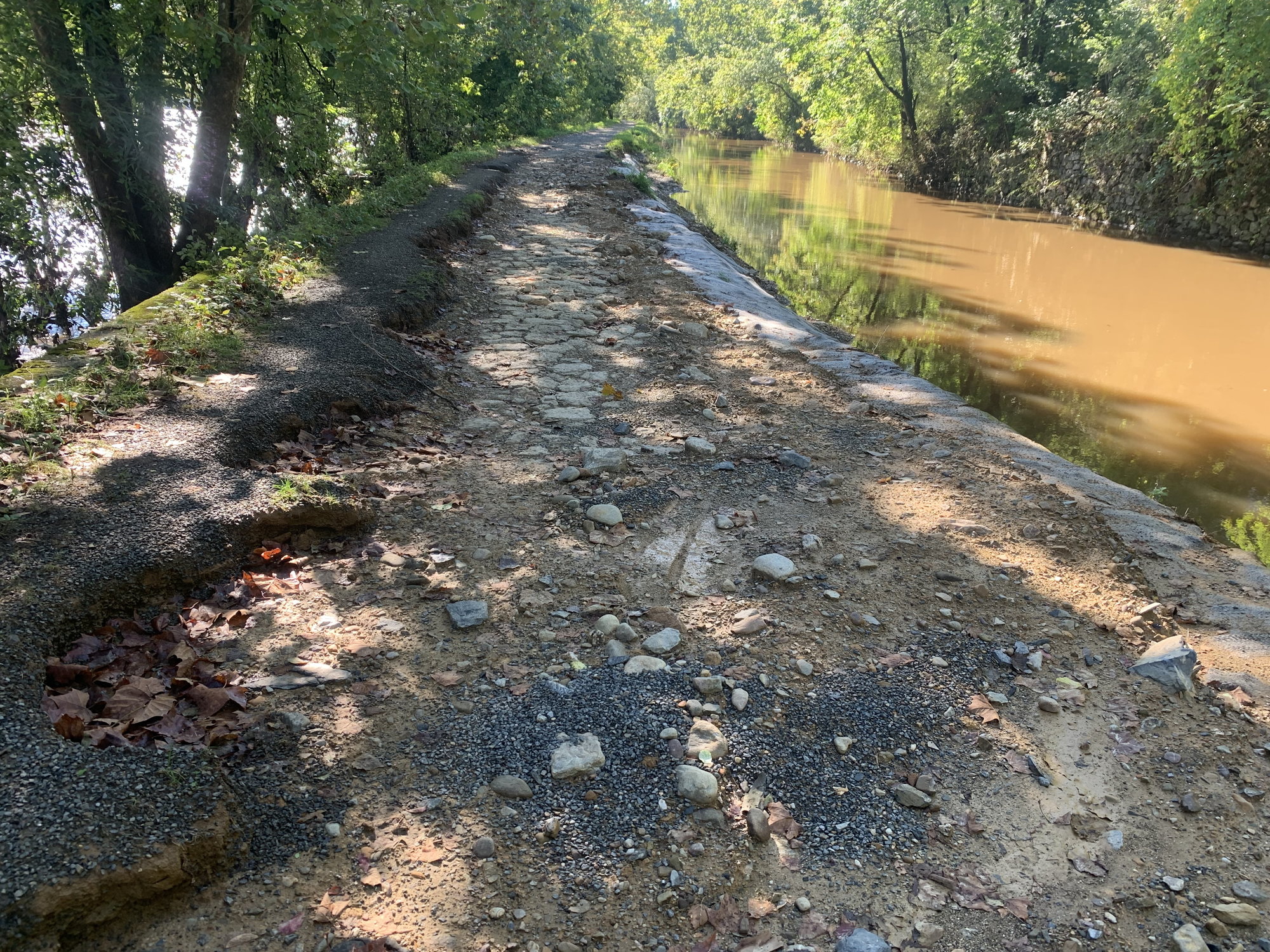
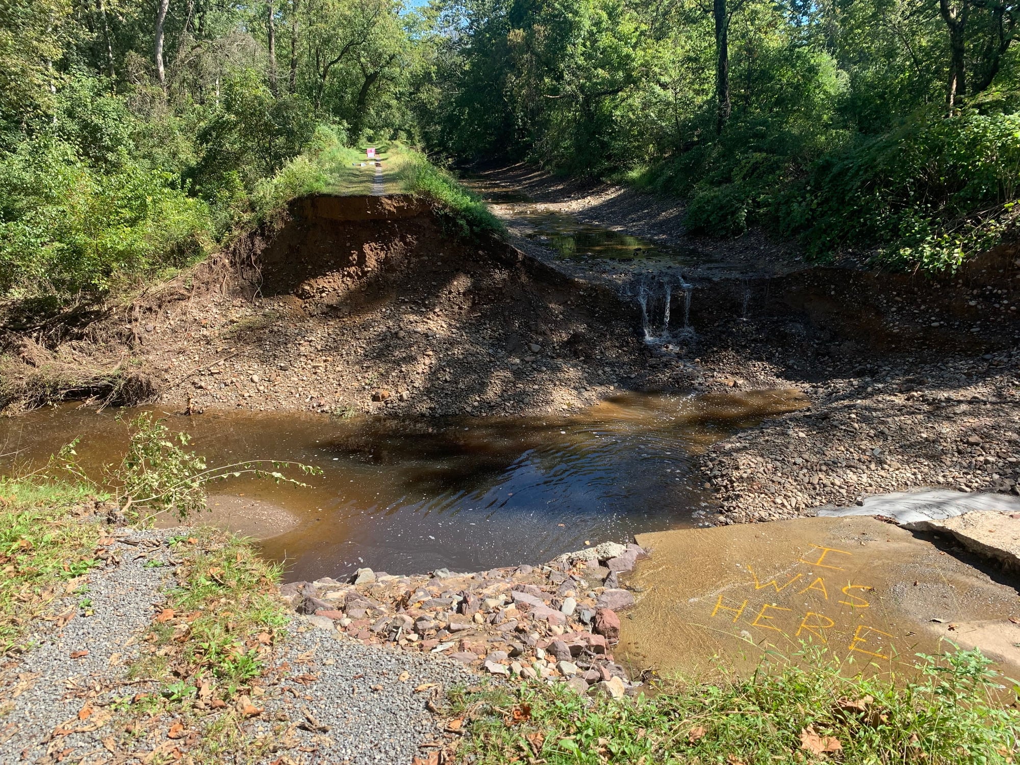
I’d avoid. Downed trees and complete washouts in places, requiring walking. The first two photos are not even of the worst segments. Once you get beyond the I-78 overpass it gets better, but still not great. Lots of growth leaving maybe a 12” track to ride in. Then about a mile north of Upper Black Eddy there is a ravine that likely won’t be repaired any time soon. The last photo doesn’t depict the true nature. That pit is probably 15’ deep, if not more, and it’s a sheer drop. Fortunately, PA 32 was not busy when I passed through on Friday afternoon.

 09-30-21, 04:50 AM
#2
Senior Member
Sorry to hear that, really enjoyed that section when we rode from Bethlehem to New Hope a few years ago. But, living near and riding a lot on the C&O Canal Towpath here, canal paths next to rivers are pretty vulnerable - that was a big reason so many of them went defunct! We have detours around damaged spots nearly every year on the C&O, after major hurricane flood damage some detours have lasted for years. I hope the D&L can be repaired faster.
09-30-21, 08:53 AM
#3
Senior Member
Thread Starter
Join Date: Jan 2010
Posts: 39,201
Mentioned: 211 Post(s)
Tagged: 1 Thread(s)
Quoted: 18393 Post(s)
Liked 15,465 Times
in
7,306 Posts
This map has information/warnings about the various sections:
D&L Map - D&L - Delaware & Lehigh (delawareandlehigh.org)
This is not the first time sections have suffered major damage. Repairs/restoration took a long time. The section through Lumberville comes to mind. That flood closed the Black Bass Hotel for at least a year and left the canal path a rocky mess. Some residents think it is a waste of money to continue to rebuild.
11-04-21, 12:15 PM
#4
I think I know nothing.
Join Date: Aug 2004
Location: NE PA
Posts: 709
Mentioned: 6 Post(s)
Tagged: 0 Thread(s)
Quoted: 233 Post(s)
Liked 290 Times
in
204 Posts
As I live in Carbon County I know very well this trail in all it's 140 miles of glory and the various non-profits that take credit for this wonderful resource and I'm quite sure that it will be several years before the section between Easton to Bristol is "fixed". According to a story on WFMZ dot com, October 14th, the state (DCNR) the (Delaware Canal) State Park Director said that before the storm, the 60 miles from Bristol to Easton had a ......75 million dollar backlog of repairs. Add another 5-10 million for new storm damage. That is just the section from Bristol to Easton, it doesn't have anything to do with the horrible sections in the City of Bethlehem, City of Easton and Bethlehem Twp., nor does it address the 6 mile urban gap from Allentown Canal Park to Coplay. And no one knows how much money the state is paying to do work on the trail near White Haven.
The city of Easton has just announced that it is going to fund a study to determine the best way to connect the upper city to the trail, probably by constructing a bridge over the Lehigh River. There is this big pie in the sky notion that people might use this trail as a commuter venue. One would think they would get the main thoroughfare in order before adding any lace trim but this is PA.
The towpath along the Delaware Canal should be filled in in many places, that would solve the money drain while still providing the recreation opportunity. Instead, they do expensive patches which result in frequent trail closures. They still could leave the historic ruins in place. I'm all for historic preservation but this is a money pit.
Last edited by Thomas15; 11-04-21 at 12:21 PM.
11-04-21, 12:36 PM
#5
Senior Member
Thread Starter
Join Date: Jan 2010
Posts: 39,201
Mentioned: 211 Post(s)
Tagged: 1 Thread(s)
Quoted: 18393 Post(s)
Liked 15,465 Times
in
7,306 Posts
At least once you get to Upper Black Eddy you can cross over to Milford, NJ. Maybe a mile or so south you can then pick up the D&R Feeder Canal Path. I don't that sustained nearly as much damage. One exception I do know about is at the north end of Lambertville. The viaduct over Alexauken Creek Was taken out. You can stay on the river side of the canal, but the path is rougher. I simply took roads and streets in L'Ville to get to the bridge in New Hope.
11-04-21, 05:13 PM
#6
I think I know nothing.
Join Date: Aug 2004
Location: NE PA
Posts: 709
Mentioned: 6 Post(s)
Tagged: 0 Thread(s)
Quoted: 233 Post(s)
Liked 290 Times
in
204 Posts
There are roughly 5 signs total and maybe 3 mile markers between Easton and Bristol, 60 miles. The loop crossing at Center Bridge and the one just north of the Virginia Forest trailhead are easy to find. The one at Frenchtown forget it, the D&L is at least a half mile from the river at that point and last time I was there, in July, there was not one sign pointing the way. Hard to believe this is a state park.
It is unsafe to take the Calhoon St bridge on the NJ side to the D&R, the section of the D&L south of Morrisville to Bristol is devoid of any recreational value, is spooky in places, strewn with litter and dangerous, a complete waste of money. I have spent hours searching for some clue as to the cost of the tunnel under the rail yard in Morrisville, it connects a very undesirable section of the trail to another undesirable section of the trail. Once you make it to the UHaul on Rt 13 that's it unless you want to cross the 8 lanes of traffic hell. And if you go ahead and do that you will be forever asking yourself "what is the point of all this?" And the bike lane on the new Scudders Falls bridge is probably no kidding a 20 million dollar price tag.
I was going to write a review of the entire 140 miles for trail link and for that reason I traveled the whole thing in both directions last summer. My notes were so negative I decided to skip it. Yes, the section from Cementon to the Black Diamond is nice, Allentown to Easton could be nice but Easton the Bristol is never going to be a quality experience ever again. The state lacks the money and the will to put $80 million into this which is by the way about 1.3 million dollars per mile. Honestly Zwift is more entertaining than the Allentown to Bristol portion of the trail.
It wouldn't surprise to to hear that there are some homeowners south of New Hope are asking, no telling, no demanding DCNR to keep their canal water out of their living rooms and basements. There are The Friends of the Delaware Canal that have it as their sole purpose in life to keep water in the historic canal prism. Nice idea but canal is crumbling. Back in the day, the canal was closed in the winter, they would take the opportunity to drain it and repair/regrout the canal. They would do this every year. Now it gets attention only when it fails.
The icing on the cake in all this is the D&L Heritage Corridor LLC which has on average a professional staff of 15 full time employees, this, the organization that "maintains" the interactive map on the website, generally describes a trail that someone like me, an individual that is on the trail 2 or 3 times a week, would not recognize. I doubt that any of them ever leave the office much less hit the trail. Sections of trail they will show closed will have been opened months ago, sections that they claim are open are actually closed.
When some project is completed, they (the D&L) takes all the credit in the media instead of those who pay for it or do the work. When something goes wrong, they blame others. During the Mansion House Bridge debacle, a $5 million project that was dedicated at the urging of the Heritage Corridor because they wanted the publicity and managed to get The Rails to Trails org to have the last of the RTT sojournes on the D&L so they dedicated the bridge then 4 hours later it was closed for a year while they fixed the on-off ramps. Because they were getting so much heat, the D&L decided to yuck up a small project, a RR crossing just north of White Haven, stating it would be opened in early 2018. That project finally opened three and a half years later in Sept 2021 and two weeks later they closed the entire trail for 5 miles beginning at this crossing for some work which could have waited until April because nothing is going to get done during the winter.
I have said in the past that the reason there is a shortage of rakes in eastern PA is because the D&L Heritage Corridor snapped them all up so that they could take turns stepping on them.
Last edited by Thomas15; 11-04-21 at 06:35 PM.
12-21-21, 08:59 PM
#7
I think I know nothing.
Join Date: Aug 2004
Location: NE PA
Posts: 709
Mentioned: 6 Post(s)
Tagged: 0 Thread(s)
Quoted: 233 Post(s)
Liked 290 Times
in
204 Posts
I wanted to add a few more thoughts and such to this thread.
Yesterday, Monday Dec 20th I had the day off from work and needed to do a little shopping so I went to the Home Depot and the Lehigh Valley Mall in Whitehall Twp. just north of Allentown. I was in my car with no bicycle with me but I decided to check the situation on the trail from the Canal Park in the boro of Northampton south in the direction of Allentown. This is a new construction of about 1.5 miles in an effort to start closing the 6 mile D&L urban gap in the Lehigh Valley. They started working on this thing in June with a target date of December for completion. So I drove over to Northampton and hiked on foot for a about a mile past the "new" Dry Run creek trail bridge which I had never actually seen. The weather has been very good since Ida but I was disappointed that really very little has been accomplished on this project. Trail users can sneek past the barrier at the circa 2006 ped bridge at the southern tip of the park, last summer that barrier was impregnable. I'm off for 11 days for holiday and I'm going to ride my Mtn bike from Lehighton south to as far as I can go, the new construction area is not suitable for anything less than a Mtn bike and construction is so little advanced that it is difficult to see exactly where the trail will finally be, will it be on the tow path or the RR side, I suspect it will bounce between the two sides.
Anyway, as I was walking back to my car thoughts of previous lacks of communication regarding the status of the trail came flooding back. I have used in the past what I call the "Rule of 1.5". This rule states that when the D&L Heritage Corridor LLC advises a project finish date, add 50% to the lead time and 50% more to the cost. Another tactic they employ is to organize a grand opening celebration affair somewhere between 2 to 4 weeks before that section of trail is closed for an additional and extended time. In the case of the mile and a half of new construction, the Heritage Corridor interactive map made it seem that once the 4 year Chestnut St bridge project was finished the trail would be passable in this area. After the bridge was opened they slowly started to talk about grant money to make the trail. By doing this they have avoided talking about this project for over 5+ years. So I'm walking along the "trail" and I decided to check the D&L Heritage Corridor LLC website and facebook and to make a long story short this project will not be done until next June sometime. So one year and 1.5 million dollars to build a 1.5 mile trail. And that doesn't include the Dry Run bridge, that was completed in 2018.
There are 2 reasons I'm going on and on about this, the first is the Heritage corridor leads potential out of state visitors astray, suppose you thought a portion of the trail would be completed in December it would be reasonable to think by the following May it should be opened but it's not.The other thing is Penndot is supposed to start replacing the Rt 329 bridge over the Lehigh river next summer, this bridge carries the trail from Cementon to Northampton and will take about 5 years to complete so a brand new gap is going to be appear on the trail which no one is talking about. It is a slim possibility that this new gap will in intermittent because they are building the new bridge next to the old one then tearing the old one down but never the less there will be heap big trail trouble along rt 329 in the future.
And this points out another failing on the public relations of the Heritage Corridor and that is they are talking up closing the Lehigh Valley trail gap and will get everyone all excited when the riverfront development project begins but even if they get trail users off Bradford and Albert Streets in the next year or two the trail will hit a wall just up the road in Northampton town.
As far as the trail from Easton to Bristol, I mentioned up thread that it would be years before that section of trail is fixed. On the D&L heritage corridor facebook and the friends of the Delaware Canal website they are both now saying that DCNR (PA State Parks) is projecting 1.5 years minimum before enough of the storm damage is repaired to allow trail users a ride on the entire 60 miles. So invoke the Rule of 1.5 and as long as no big storms hit it will be Spring of 2024 before one will ride non-stop all the way from Easton to Bristol. Keep in mind that this section of trail is a state park.
Last edited by Thomas15; 12-21-21 at 09:23 PM.
12-23-21, 08:16 AM
#8
Full Member
Join Date: Feb 2014
Location: Lehigh Valley
Posts: 247
Mentioned: 0 Post(s)
Tagged: 0 Thread(s)
Quoted: 122 Post(s)
Liked 53 Times
in
43 Posts
I wanted to add a few more thoughts and such to this thread.
Yesterday, Monday Dec 20th I had the day off from work and needed to do a little shopping so I went to the Home Depot and the Lehigh Valley Mall in Whitehall Twp. just north of Allentown. I was in my car with no bicycle with me but I decided to check the situation on the trail from the Canal Park in the boro of Northampton south in the direction of Allentown. This is a new construction of about 1.5 miles in an effort to start closing the 6 mile D&L urban gap in the Lehigh Valley. They started working on this thing in June with a target date of December for completion. So I drove over to Northampton and hiked on foot for a about a mile past the "new" Dry Run creek trail bridge which I had never actually seen. The weather has been very good since Ida but I was disappointed that really very little has been accomplished on this project. Trail users can sneek past the barrier at the circa 2006 ped bridge at the southern tip of the park, last summer that barrier was impregnable. I'm off for 11 days for holiday and I'm going to ride my Mtn bike from Lehighton south to as far as I can go, the new construction area is not suitable for anything less than a Mtn bike and construction is so little advanced that it is difficult to see exactly where the trail will finally be, will it be on the tow path or the RR side, I suspect it will bounce between the two sides.
Anyway, as I was walking back to my car thoughts of previous lacks of communication regarding the status of the trail came flooding back. I have used in the past what I call the "Rule of 1.5". This rule states that when the D&L Heritage Corridor LLC advises a project finish date, add 50% to the lead time and 50% more to the cost. Another tactic they employ is to organize a grand opening celebration affair somewhere between 2 to 4 weeks before that section of trail is closed for an additional and extended time. In the case of the mile and a half of new construction, the Heritage Corridor interactive map made it seem that once the 4 year Chestnut St bridge project was finished the trail would be passable in this area. After the bridge was opened they slowly started to talk about grant money to make the trail. By doing this they have avoided talking about this project for over 5+ years. So I'm walking along the "trail" and I decided to check the D&L Heritage Corridor LLC website and facebook and to make a long story short this project will not be done until next June sometime. So one year and 1.5 million dollars to build a 1.5 mile trail. And that doesn't include the Dry Run bridge, that was completed in 2018.
There are 2 reasons I'm going on and on about this, the first is the Heritage corridor leads potential out of state visitors astray, suppose you thought a portion of the trail would be completed in December it would be reasonable to think by the following May it should be opened but it's not.The other thing is Penndot is supposed to start replacing the Rt 329 bridge over the Lehigh river next summer, this bridge carries the trail from Cementon to Northampton and will take about 5 years to complete so a brand new gap is going to be appear on the trail which no one is talking about. It is a slim possibility that this new gap will in intermittent because they are building the new bridge next to the old one then tearing the old one down but never the less there will be heap big trail trouble along rt 329 in the future.
And this points out another failing on the public relations of the Heritage Corridor and that is they are talking up closing the Lehigh Valley trail gap and will get everyone all excited when the riverfront development project begins but even if they get trail users off Bradford and Albert Streets in the next year or two the trail will hit a wall just up the road in Northampton town.
As far as the trail from Easton to Bristol, I mentioned up thread that it would be years before that section of trail is fixed. On the D&L heritage corridor facebook and the friends of the Delaware Canal website they are both now saying that DCNR (PA State Parks) is projecting 1.5 years minimum before enough of the storm damage is repaired to allow trail users a ride on the entire 60 miles. So invoke the Rule of 1.5 and as long as no big storms hit it will be Spring of 2024 before one will ride non-stop all the way from Easton to Bristol. Keep in mind that this section of trail is a state park.
Yesterday, Monday Dec 20th I had the day off from work and needed to do a little shopping so I went to the Home Depot and the Lehigh Valley Mall in Whitehall Twp. just north of Allentown. I was in my car with no bicycle with me but I decided to check the situation on the trail from the Canal Park in the boro of Northampton south in the direction of Allentown. This is a new construction of about 1.5 miles in an effort to start closing the 6 mile D&L urban gap in the Lehigh Valley. They started working on this thing in June with a target date of December for completion. So I drove over to Northampton and hiked on foot for a about a mile past the "new" Dry Run creek trail bridge which I had never actually seen. The weather has been very good since Ida but I was disappointed that really very little has been accomplished on this project. Trail users can sneek past the barrier at the circa 2006 ped bridge at the southern tip of the park, last summer that barrier was impregnable. I'm off for 11 days for holiday and I'm going to ride my Mtn bike from Lehighton south to as far as I can go, the new construction area is not suitable for anything less than a Mtn bike and construction is so little advanced that it is difficult to see exactly where the trail will finally be, will it be on the tow path or the RR side, I suspect it will bounce between the two sides.
Anyway, as I was walking back to my car thoughts of previous lacks of communication regarding the status of the trail came flooding back. I have used in the past what I call the "Rule of 1.5". This rule states that when the D&L Heritage Corridor LLC advises a project finish date, add 50% to the lead time and 50% more to the cost. Another tactic they employ is to organize a grand opening celebration affair somewhere between 2 to 4 weeks before that section of trail is closed for an additional and extended time. In the case of the mile and a half of new construction, the Heritage Corridor interactive map made it seem that once the 4 year Chestnut St bridge project was finished the trail would be passable in this area. After the bridge was opened they slowly started to talk about grant money to make the trail. By doing this they have avoided talking about this project for over 5+ years. So I'm walking along the "trail" and I decided to check the D&L Heritage Corridor LLC website and facebook and to make a long story short this project will not be done until next June sometime. So one year and 1.5 million dollars to build a 1.5 mile trail. And that doesn't include the Dry Run bridge, that was completed in 2018.
There are 2 reasons I'm going on and on about this, the first is the Heritage corridor leads potential out of state visitors astray, suppose you thought a portion of the trail would be completed in December it would be reasonable to think by the following May it should be opened but it's not.The other thing is Penndot is supposed to start replacing the Rt 329 bridge over the Lehigh river next summer, this bridge carries the trail from Cementon to Northampton and will take about 5 years to complete so a brand new gap is going to be appear on the trail which no one is talking about. It is a slim possibility that this new gap will in intermittent because they are building the new bridge next to the old one then tearing the old one down but never the less there will be heap big trail trouble along rt 329 in the future.
And this points out another failing on the public relations of the Heritage Corridor and that is they are talking up closing the Lehigh Valley trail gap and will get everyone all excited when the riverfront development project begins but even if they get trail users off Bradford and Albert Streets in the next year or two the trail will hit a wall just up the road in Northampton town.
As far as the trail from Easton to Bristol, I mentioned up thread that it would be years before that section of trail is fixed. On the D&L heritage corridor facebook and the friends of the Delaware Canal website they are both now saying that DCNR (PA State Parks) is projecting 1.5 years minimum before enough of the storm damage is repaired to allow trail users a ride on the entire 60 miles. So invoke the Rule of 1.5 and as long as no big storms hit it will be Spring of 2024 before one will ride non-stop all the way from Easton to Bristol. Keep in mind that this section of trail is a state park.
For any non-locals, I should point out that cycling between Easton and Milford, NJ on the Jersey side is a reasonable option. The roads are mostly quiet and well traveled by cyclists.
Likes For force10:
12-23-21, 08:45 AM
#9
I think I know nothing.
Join Date: Aug 2004
Location: NE PA
Posts: 709
Mentioned: 6 Post(s)
Tagged: 0 Thread(s)
Quoted: 233 Post(s)
Liked 290 Times
in
204 Posts
I think the thing that bothers me the most about the Heritage Corridor LLC is that when asked what the average Joe can do to help improve the trail experience, they will suggest a donation to themselves. The problem is they don’t own a single inch of the trail. Their biggest contribution to the trail itself is they assist those that do own it with grant writing help, but a donation to them will have little to no effect on the conditions or the visitor experience on the trail.
Northampton Boro south.
Notice here that on Sept 22 a blog post referenced the work I mentioned upthread, the 1.5 mile new construction from Northampton Canal Park south, and the reference to the June 3 groundbreaking. There is no mention of the project finish date.
https://delawareandlehigh.org/blog/e...pment-updates/
Again no mention of the finish date but the blog links to a local media story on the groundbreaking that does give a date of December 2021.
https://www.wfmz.com/news/area/lehig...9dbfc35fd.html
The Heritage Corridor LLC interactive map for months also held to a Dec 2021 date. Finally on Dec 20, the Heritage Corridor LLC puts it in a blog:
https://delawareandlehigh.org/blog/t...gh-valley-gap/
Better late than never but what about the Rt. 329 bridge replacement project?
Middleburg to Tannery
Back in late 2017, most of the crossing at Middleburg Rd, two miles north of White Haven, was in place, the Heritage Corridor LLC announced that the crossing would be dedicated in early 2018. It should be noted that this blog entry was posted at the height of the Mansion House Bridge fiasco:
https://delawareandlehigh.org/blog/d...ct-big-impact/
Three and a half years later the crossing is complete:
https://www.wfmz.com/news/area/lehig...9dbfc35fd.html
Two weeks later the trail from the brand new crossing is closed, as is the trail itself from Middleburg Rd to White Haven (north), then from White Haven (South) to Lehigh Tannery, two miles south of White Haven. The .3 miles of trail in White Haven Boro remains open as the trail there is share the road and to close it would require closing Main Street.
https://www.media.pa.gov/Pages/DCNR_...spx?newsid=773
Seemingly oblivious to this trail closure, on Sept 21, the Heritage Corridor released this blog urging the public to take advantage of the (now closed) trail in White Haven…
https://delawareandlehigh.org/blog/f...-the-dl-trail/
As a personal note, I put in 2000+ miles/year on this trail. I have seen my share of bicycle mishaps there but the only actual crash I have come across was in summer of 2019 at the Middleburg Rd crossing. And my closest near death experience on a bike was at this crossing about 6 weeks later when a tri-axle came to within a micron of invading my personal space.
My point in all this is simple. You simply cannot trust the information the Heritage Corridor LLC puts out regarding this trail. Too many people on the payroll, too little actual experience on the trail itself.
Last edited by Thomas15; 12-23-21 at 09:50 AM.
12-23-21, 08:59 AM
#10
Senior Member
Join Date: Apr 2021
Posts: 4,083
Mentioned: 6 Post(s)
Tagged: 0 Thread(s)
Quoted: 2332 Post(s)
Liked 2,097 Times
in
1,314 Posts
Easton to Stockton is fine on Rt 29, it has a good shoulder although Milford to Frenchtown isn't the best. Stockton to Lambertville is too narrow and little shoulder for my tastes, I take the tow path although you can't get all the way to OwowCow on the towpath now due to the storm damage.
Likes For GhostRider62:
12-23-21, 09:10 AM
#11
I think I know nothing.
Join Date: Aug 2004
Location: NE PA
Posts: 709
Mentioned: 6 Post(s)
Tagged: 0 Thread(s)
Quoted: 233 Post(s)
Liked 290 Times
in
204 Posts
I will post my adventures for sure. Also, since you mention using the NJ side, on my short list of things to do before I get too old to do them is to ride up Fiddlers Elbow Rd in nearby Harmony. Thats not trail riding though. I work in PBurg btw.
Likes For force10:
12-26-21, 04:21 PM
#13
Senior Member
Thread Starter
Join Date: Jan 2010
Posts: 39,201
Mentioned: 211 Post(s)
Tagged: 1 Thread(s)
Quoted: 18393 Post(s)
Liked 15,465 Times
in
7,306 Posts
That’s the way ACA’s Atlantic Cost route goes. I’ve ridden it countless times. Excellent choice. The ACA route actually uses the NJ side south from Belvidere. The 13 miles between there and Philipsburg, NJ is terrific. The low, narrow railroad overpasses means no large vehicles. If I encounter 6 moving vehicles along that stretch it’s been a high volume traffic day.
12-26-21, 04:22 PM
#14
Senior Member
Thread Starter
Join Date: Jan 2010
Posts: 39,201
Mentioned: 211 Post(s)
Tagged: 1 Thread(s)
Quoted: 18393 Post(s)
Liked 15,465 Times
in
7,306 Posts
 12-26-21, 04:29 PM
#15
Senior Member
Thread Starter
Join Date: Jan 2010
Posts: 39,201
Mentioned: 211 Post(s)
Tagged: 1 Thread(s)
Quoted: 18393 Post(s)
Liked 15,465 Times
in
7,306 Posts
Easton to Stockton is fine on Rt 29, it has a good shoulder although Milford to Frenchtown isn't the best. Stockton to Lambertville is too narrow and little shoulder for my tastes, I take the tow path although you can't get all the way to OwowCow on the towpath now due to the storm damage.
Yes. Stockton to L’Ville on 29 is not great. I took the path for that stretch in September. It was still pretty good. But the viaduct at the north end of L’Ville was gone, so I got on 29 then made a right on Cherry at the Rago auction house and then Union. The coffee and pizza places on Union were severely damaged by flooding.
12-27-21, 05:05 AM
#16
Senior Member
Join Date: Apr 2021
Posts: 4,083
Mentioned: 6 Post(s)
Tagged: 0 Thread(s)
Quoted: 2332 Post(s)
Liked 2,097 Times
in
1,314 Posts
NJ 29 doesn’t start south until Frenchtown.
Yes. Stockton to L’Ville on 29 is not great. I took the path for that stretch in September. It was still pretty good. But the viaduct at the north end of L’Ville was gone, so I got on 29 then made a right on Cherry at the Rago auction house and then Union. The coffee and pizza places on Union were severely damaged by flooding.
Yes. Stockton to L’Ville on 29 is not great. I took the path for that stretch in September. It was still pretty good. But the viaduct at the north end of L’Ville was gone, so I got on 29 then made a right on Cherry at the Rago auction house and then Union. The coffee and pizza places on Union were severely damaged by flooding.
You're right about Rt 29. I just think of the road along the river as all Rt 29 but if someone is trying to make their way south from Easton, it is probably a better way than the other side of the river at this time.
12-31-21, 11:57 AM
#17
I think I know nothing.
Join Date: Aug 2004
Location: NE PA
Posts: 709
Mentioned: 6 Post(s)
Tagged: 0 Thread(s)
Quoted: 233 Post(s)
Liked 290 Times
in
204 Posts
Our local newspaper is reporting that a $194,500.00 state grant was awarded to do some work on the 1 mile stretch in Franklin Twp (Carbon County) beginning in Weissport moving north. I assume this will replace the two narrow bridges over outflows (scenes of many crashes) and fix that little dip just north of the Weissport trailhead,
A few personal opinions and comments on this 4 mile section of the D&L (Weissport to JT). One of the nicest (scenic) sections of the entire 140 miles of trail and generally kept in decent shape although some sections of fencing between the towpath and river need repairs and a few of the benches are broken. There is a dip about 2 miles north of Weissport that I think exposes the original towpath surface. I only know of one other place on the entire 140 miles with a similar dip that is near Bethlehem somewhere.
When you go to the Rails to Trail website and view the Trail Link data page for the D&L, the introduction has a picture taken from a drone of the D&L, that picture was taken along this section of trail about 2 miles north of Weissport.
There are several commercial outfitters that rent bikes and offer shuttle services along most of the Anthrocite section of the D&L. Some offer multi-day bike rides and/or whitewater rafting trips. The Reading, Blue Mountain and Northern Rail Road runs train rides along parts of the D&L and will load your bike on the train and take you up the line, drop you off and then you can ride your bike back to the starting point. Sometimes they run steam locomotives on this line.
Back to the Franklin Twp upgrades, no timeline is given but I would assume this summer or fall will probably have some trail closures we shall see.
https://www.tnonline.com/20211231/jt...t-state-funds/
01-03-22, 08:46 AM
#18
Senior Member
Thread Starter
Join Date: Jan 2010
Posts: 39,201
Mentioned: 211 Post(s)
Tagged: 1 Thread(s)
Quoted: 18393 Post(s)
Liked 15,465 Times
in
7,306 Posts
There is a dip about 2 miles north of Weissport that I think exposes the original towpath surface. I only know of one other place on the entire 140 miles with a similar dip that is near Bethlehem somewhere.
The Reading, Blue Mountain and Northern Rail Road runs train rides along parts of the D&L and will load your bike on the train and take you up the line, drop you off and then you can ride your bike back to the starting point.
The Reading, Blue Mountain and Northern Rail Road runs train rides along parts of the D&L and will load your bike on the train and take you up the line, drop you off and then you can ride your bike back to the starting point.
Back in the spring of 2017 I did the Bike Train with three friends, including two who were casual riders. They very much enjoyed it. Not only do I ride, I work in the rail business.
01-08-22, 02:52 PM
#19
I think I know nothing.
Join Date: Aug 2004
Location: NE PA
Posts: 709
Mentioned: 6 Post(s)
Tagged: 0 Thread(s)
Quoted: 233 Post(s)
Liked 290 Times
in
204 Posts
I have only ridden once between Weissport and JT, but I remember that dip. Could it have been spillway, like the one south of Easton? The crazy thing is that when I rode south from Easton after Ida flooding I was was worried about that spillway being inundated with water. Turned out, it was totally dry. Not even the gentle flow like normal.
Back in the spring of 2017 I did the Bike Train with three friends, including two who were casual riders. They very much enjoyed it. Not only do I ride, I work in the rail business.
Back in the spring of 2017 I did the Bike Train with three friends, including two who were casual riders. They very much enjoyed it. Not only do I ride, I work in the rail business.
Before they started building the Mansion House Bridge there was a much bigger washout right by where the trail goes under a train trestle. That was so big only the hardcore would ride through it without dismounting the bike. Somewhere around the time you were there it was filled in and coated with concrete. The is a similar fix south of Easton.
I have two friends (they are retired) that work as conductors on the Lehigh Gorge Scenic Railroad they both love what they do. My wife and I rode it last spring while under steam. Love steam!
Likes For Thomas15:
02-17-22, 10:47 PM
#21
I think I know nothing.
Join Date: Aug 2004
Location: NE PA
Posts: 709
Mentioned: 6 Post(s)
Tagged: 0 Thread(s)
Quoted: 233 Post(s)
Liked 290 Times
in
204 Posts
A few vague D&L updates.
The D&L "interactive" map on the LLC website has revised the re-opening date of 5 miles of trail near White Haven on the northern section of the trail. It was "Spring 2022" now it is "Summer 2022". This must have just happened as I check it about once a week and had not noticed this before. Pocono Biking, an outfit that rents bikes and provides shuttle services for trail users is still showing a Spring 2022 re-opening on their website. DCNR* is also showing a May 2022 date. Interesting to note that the owner of Pocono Biking is on the BOD of the D&L LLC. This is a project being funded and (mis)-managed by PA DCNR (State Park) so there is no incentive to hold to any time schedule or inform the public on construction time progress. Just don't expect this section to open much before Labor Day.
* https://www.dcnr.pa.gov/StateParks/F...s/default.aspx
There is a recent article (today actually) on WFMZ dot com discussing in general terms construction projects in the Lehigh Valley. There is a passing reference to the rt 329 highway bridge in Cementon which i mention above. Construction is going to begin/has begun, sometime, sometime soon or maybe sometime later but sometime for sure. Key word here is sometime. I doubt anything has started yet. It is amazing the lack of public information on this project that will be a huge pain in saddle for those in the area. As far as the D&L is concerned it will probably, in all likely hood, result in a multi year obstruction of the trial.
For your reading pleasure....
https://www.wfmz.com/news/area/lehig...8ab43f6d4.html
Last edited by Thomas15; 02-18-22 at 10:27 AM.
03-02-22, 12:50 PM
#22
I think I know nothing.
Join Date: Aug 2004
Location: NE PA
Posts: 709
Mentioned: 6 Post(s)
Tagged: 0 Thread(s)
Quoted: 233 Post(s)
Liked 290 Times
in
204 Posts
I have noticed that the D&L LLC has just now marked the entire section between Jim Thorpe (Glen Onoko) to Black Diamond having obstructions and closures due to a repairs to the bridge at Rockport. In laymen's terms this means that the entire section through the gorge (25 miles) is not viable. For their part, on their interactive map of the trail, the D&L LLC cut and pasted the warning from the Tannery Rd to Middleburg Rd sections to the two additional sections (Onoko to Rockport, Rockport to While Haven). This is the first I have heard about repairs to the bridge in Rockport. I'm currently struggling with a loss of self-esteem because I thought I was fairly well infirmed on D&L trail happenings. Again this is a state park so they can do whatever they want whenever they want. It should be noted that none of the trail from Glen Onoko to Black Diamond was damaged (with some minor exceptions) from TS Ida.
At this point in time, about 100 miles of the 140 miles of the D&L is closed or restricted. Late spring or summer or some other time other time it will re-open. Very bad news for this regions economy has a lot invested in outdoor recreation.
On the D&L facebook they have announced their "1st Annual Virtual State of the Trail" for March 29th.
LOL.
From the D&L interactive map:
Lehigh Gorge State Park is undertaking a sizeable rehabilitation project extending from the new Middleburg Road crossing south to Tannery Road. Beginning Monday 9/27, the construction site from Middleburg Road (MM 132) to White Haven North Trailhead (MM 130.5) and White Haven South Trailhead (MM 130.2) to Tannery Road (MM 128.6) will be CLOSED to the public seven days a week until Summer 2022. Learn more https://bit.ly/3jGTwX3
03-02-22, 01:34 PM
#23
Senior Member

Join Date: Nov 2014
Location: Eugene, Oregon, USA
Posts: 27,547
Mentioned: 217 Post(s)
Tagged: 0 Thread(s)
Quoted: 18347 Post(s)
Liked 4,497 Times
in
3,344 Posts
With hiking or jogging in the past, I've moved any tree that was 6" or smaller out of the trail.
Those larger trees take a bit more work. But, a local cycling club could do wonders with organizing a work crew to do trail clearing. I don't know about chainsaw regulations, but I've cut trees that size with bucksaws.
I don't know about partial washouts of the trail. One could knock down anything that was dangerous, but it would really require equipment to fix it right. Bigger tires?
For small bridge washouts, sometimes local government agencies will supply materials and support for rebuilding if a community organization can supply some volunteer labor.
03-03-22, 09:22 AM
#24
Full Member
Join Date: Feb 2014
Location: Lehigh Valley
Posts: 247
Mentioned: 0 Post(s)
Tagged: 0 Thread(s)
Quoted: 122 Post(s)
Liked 53 Times
in
43 Posts
FYI. State of the Trail Zoom address at the end of the month.
https://delawareandlehigh.org/explor...-of-the-trail/
https://delawareandlehigh.org/explor...-of-the-trail/

