


Trip planning and elevation analysis - example for newer bike tourists
 09-22-21, 07:14 AM
#26
Senior Member
Join Date: Aug 2010
Location: Madison, WI
Posts: 11,172
Bikes: 1961 Ideor, 1966 Perfekt 3 Speed AB Hub, 1994 Bridgestone MB-6, 2006 Airnimal Joey, 2009 Thorn Sherpa, 2013 Thorn Nomad MkII, 2015 VO Pass Hunter, 2017 Lynskey Backroad, 2017 Raleigh Gran Prix, 1980s Bianchi Mixte on a trainer. Others are now gone.
Mentioned: 47 Post(s)
Tagged: 0 Thread(s)
Quoted: 3450 Post(s)
Liked 1,449 Times
in
1,130 Posts
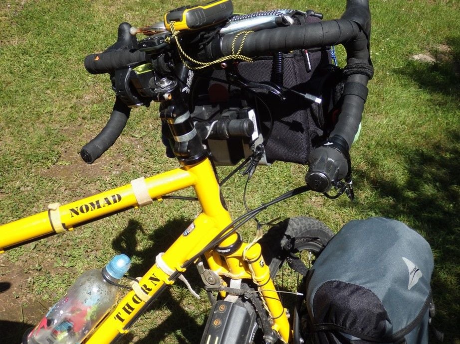
I was going to ask about those. Very slick.
By the way, I thought I had a busy "cockpit". Glad to see I'm not the only one with a lot of gizmos around the bars.
Edit:
There was another link inside the one posted that takes you to a version with a brass ball. That would probably solve the bubble size changing with elevation, temp, and pressure.
https://www.amazon.com/dp/B06XCMXRVP...xpY2s9dHJ1ZQ==
I do not think it is THAT busy, just in case you missed it I have interrupter type brake levers that also takes space on the bars. And I use a second stem or something similar to lower my handle bar bracket too, that moves my handlebar bracket off of the bars. If you did not notice, the HRM and inclinometer are on a separate bracket that I made that is attached at the stem cap bolt. Thus behind the bars, freeing up some bar space. Thus, I packed in a lot without using that much bar space.

Likes For Tourist in MSN:
09-22-21, 11:02 AM
#27
Senior Member
Thread Starter
Join Date: Apr 2013
Posts: 1,173
Bikes: Surly Disk Trucker, 2014 w/Brooks Flyer Special saddle, Tubus racks - Duo front/Logo Evo rear, 2019 Dahon Mariner D8, Both bikes share Ortlieb Packer Plus series panniers, Garmin Edge 1000
Mentioned: 2 Post(s)
Tagged: 0 Thread(s)
Quoted: 405 Post(s)
Liked 115 Times
in
99 Posts
Here is another interesting example. This is part of a future long tour idea I have to get out to the East Coast. It bridges the Ohio to Erie and the Panhandle Trail, that leads (thru the S end of the Montour route in PA) to the GAP - that is the terminus of this route so far (McKeesport, PA).
The start is the Ohio to Erie Trail in Westerville. However, there are about 15-20 miles of roads that pass through several river valleys. That I have rode before on a couple trips - and I can say for certainty the climbs through the valleys are actually pretty hard because they are steep. Keeping the miles "short" through there over the course of a day is a good idea - that works a lot better for me (I did a hair under 20mi on my Ohio to Erie trip that leg and, with the load, that was about as much as I'd want to do through there).
If you look at the peak near the 25 mile mark - that is a really high "point" on the route. I think it is one of the highest, if not the highest, on the Ohio to Erie. That, at first glance, seems to be blatantly obvious as being a "hard spot" to get through. I can say with certainty that is a much easier ride to get through there than what appear to be short climbs through all the valleys on the route I have to get to the trail. The reason being is what appears to be a huge elevation in the graph is a much shallower grade. You can't see it on the screen shot, but on the RWGPS page you can scroll around the routes and it shows you both elevation and grade. This "peak" has less than a 2% grade. Yeah, you're going up going north in to it so it will slow you down - but it isn't 15 miles of "get off the bike and walk". The valleys at the start run are "get off the bike and walk" in some places. The condensed, if you will, elevation chart for a long trip squeezes the grades and distorts them so they need drilling in to for a better mind's eye of what you're up against.
The 85-115 mile area is ride #3 in the 1st post - a pretty rough segment, for me.
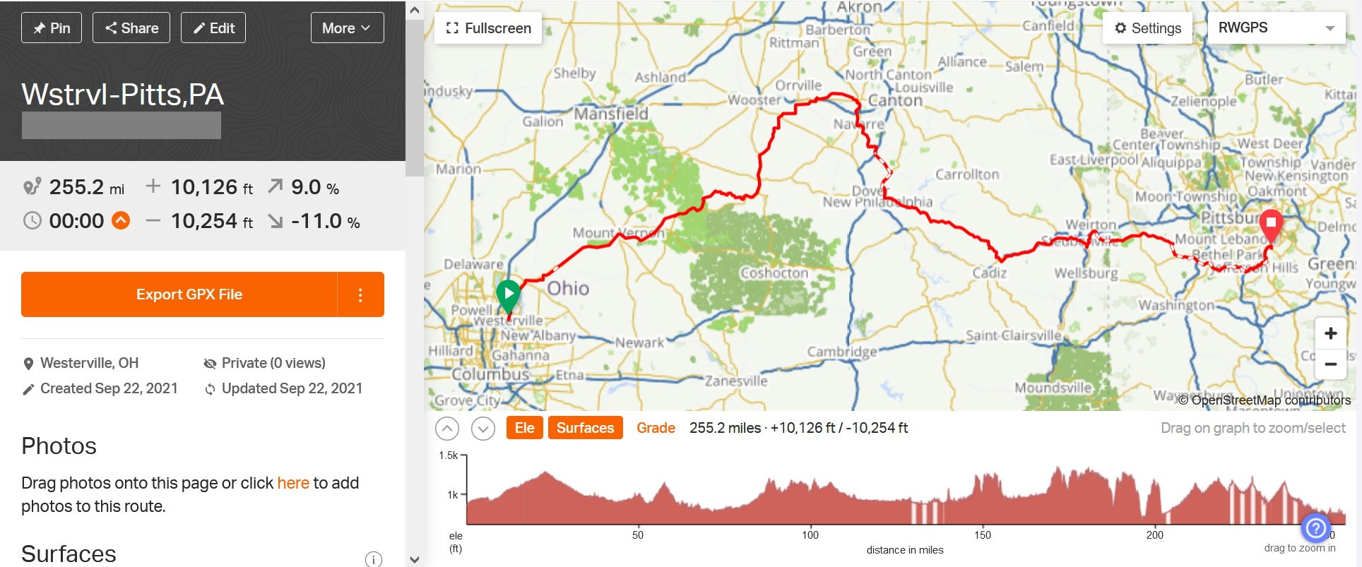
The total elevation gain on this segment is 10,126ft. Most of that is in the steep climbs you see in the graph. At around the 185mi mark there is a sharp dip, then again at 195mi. That is a road segment that passes through, pretty obviously, a couple ridges and valleys. 195mi is the Ohio River passing from OH to WV. The climb @ 205mi is the Panhandle Trail - the low point is where I would jump on that trail. The climb up is the Panhandle Trail in to PA. After that climb on the Panhandle the elevation mellows out quite a bit, overall.
However, the sharp peak you see at about the 225mi mark I am showing as much as a 6.4% grade (the tip is through National Tunnel, so you don't get to the ridge top - they tunneled thru it). Those "high peaks", going back to the earlier example at around the 25mi mark, aren't necessarily hard to get through. Its just when you compress the mileage of a "long tour" any elevation that is there shows up as a "peak". You have to drill down and check either the grade (as RWGPS does), check a topographic map, or check the street level view of the area - in person or google/other mapping provider.
Here is a good example Tourist in MSN posted earlier that goes right along with the subject of the grades:
As to his last point - that is the purpose of the thread - route plan. You have to know your numbers in order to do that. Then if you study the routes that grade would be found.
Then you have 2 choices.
1. If there are other routes available that let you bypass the grade and are ride-able (use your judgement - traffic, road conditions, detour mileage, etc) - go another route;
2. Find a way to deal with it. Break up mileage and do just the climb in a day, or find somewhere in between the climb to shut down and split it over a couple days.
Just for grins I ran the numbers on that grade. If it was a steady 13% grade over 4km that would be 2.48 miles and 1700' of elevation gain, straight up basically. That's a heck of a climb. I can't imagine 13% being the continuous grade, though. Maybe in places it gets that steep. Even if the average grade is 1/2 that at 6.5% (still a challenging grade) - that would be 850' gain.
The start is the Ohio to Erie Trail in Westerville. However, there are about 15-20 miles of roads that pass through several river valleys. That I have rode before on a couple trips - and I can say for certainty the climbs through the valleys are actually pretty hard because they are steep. Keeping the miles "short" through there over the course of a day is a good idea - that works a lot better for me (I did a hair under 20mi on my Ohio to Erie trip that leg and, with the load, that was about as much as I'd want to do through there).
If you look at the peak near the 25 mile mark - that is a really high "point" on the route. I think it is one of the highest, if not the highest, on the Ohio to Erie. That, at first glance, seems to be blatantly obvious as being a "hard spot" to get through. I can say with certainty that is a much easier ride to get through there than what appear to be short climbs through all the valleys on the route I have to get to the trail. The reason being is what appears to be a huge elevation in the graph is a much shallower grade. You can't see it on the screen shot, but on the RWGPS page you can scroll around the routes and it shows you both elevation and grade. This "peak" has less than a 2% grade. Yeah, you're going up going north in to it so it will slow you down - but it isn't 15 miles of "get off the bike and walk". The valleys at the start run are "get off the bike and walk" in some places. The condensed, if you will, elevation chart for a long trip squeezes the grades and distorts them so they need drilling in to for a better mind's eye of what you're up against.
The 85-115 mile area is ride #3 in the 1st post - a pretty rough segment, for me.
The total elevation gain on this segment is 10,126ft. Most of that is in the steep climbs you see in the graph. At around the 185mi mark there is a sharp dip, then again at 195mi. That is a road segment that passes through, pretty obviously, a couple ridges and valleys. 195mi is the Ohio River passing from OH to WV. The climb @ 205mi is the Panhandle Trail - the low point is where I would jump on that trail. The climb up is the Panhandle Trail in to PA. After that climb on the Panhandle the elevation mellows out quite a bit, overall.
However, the sharp peak you see at about the 225mi mark I am showing as much as a 6.4% grade (the tip is through National Tunnel, so you don't get to the ridge top - they tunneled thru it). Those "high peaks", going back to the earlier example at around the 25mi mark, aren't necessarily hard to get through. Its just when you compress the mileage of a "long tour" any elevation that is there shows up as a "peak". You have to drill down and check either the grade (as RWGPS does), check a topographic map, or check the street level view of the area - in person or google/other mapping provider.
Here is a good example Tourist in MSN posted earlier that goes right along with the subject of the grades:
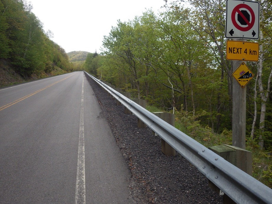
Photo below, different trip, when I see that I have to go for several km up a hill with 13 percent grade, I grimmace, get off the bike and start walking as I know that grade would push my heart rate too high if I tried to pedal.
I can't imagine how you would ever get the load you are considering up a hill like that.
I can't imagine how you would ever get the load you are considering up a hill like that.
Then you have 2 choices.
1. If there are other routes available that let you bypass the grade and are ride-able (use your judgement - traffic, road conditions, detour mileage, etc) - go another route;
2. Find a way to deal with it. Break up mileage and do just the climb in a day, or find somewhere in between the climb to shut down and split it over a couple days.
Just for grins I ran the numbers on that grade. If it was a steady 13% grade over 4km that would be 2.48 miles and 1700' of elevation gain, straight up basically. That's a heck of a climb. I can't imagine 13% being the continuous grade, though. Maybe in places it gets that steep. Even if the average grade is 1/2 that at 6.5% (still a challenging grade) - that would be 850' gain.
09-22-21, 03:37 PM
#28
Senior Member
Join Date: Aug 2010
Location: Madison, WI
Posts: 11,172
Bikes: 1961 Ideor, 1966 Perfekt 3 Speed AB Hub, 1994 Bridgestone MB-6, 2006 Airnimal Joey, 2009 Thorn Sherpa, 2013 Thorn Nomad MkII, 2015 VO Pass Hunter, 2017 Lynskey Backroad, 2017 Raleigh Gran Prix, 1980s Bianchi Mixte on a trainer. Others are now gone.
Mentioned: 47 Post(s)
Tagged: 0 Thread(s)
Quoted: 3450 Post(s)
Liked 1,449 Times
in
1,130 Posts
...
Just for grins I ran the numbers on that grade. If it was a steady 13% grade over 4km that would be 2.48 miles and 1700' of elevation gain, straight up basically. That's a heck of a climb. I can't imagine 13% being the continuous grade, though. Maybe in places it gets that steep. Even if the average grade is 1/2 that at 6.5% (still a challenging grade) - that would be 850' gain.
Just for grins I ran the numbers on that grade. If it was a steady 13% grade over 4km that would be 2.48 miles and 1700' of elevation gain, straight up basically. That's a heck of a climb. I can't imagine 13% being the continuous grade, though. Maybe in places it gets that steep. Even if the average grade is 1/2 that at 6.5% (still a challenging grade) - that would be 850' gain.
Disregard the negative elevation, my GPS does not have a pressure sensor and GPS elevations are not very reliable so if it says I am a few feet underwater, that is not accurate but not a surprise since I was near the coast.
Likes For Tourist in MSN:
09-23-21, 08:25 AM
#29
Full Member
Join Date: Sep 2005
Location: Tulsa, OK
Posts: 451
Bikes: Co-Motion Americano Pinion P18; Co-Motion Americano Rohloff; Thorn Nomad MkII, Robert Beckman Skakkit (FOR SALE), Santana Tandem, ICE Adventure FS
Mentioned: 1 Post(s)
Tagged: 0 Thread(s)
Quoted: 169 Post(s)
Liked 64 Times
in
48 Posts
KC8,
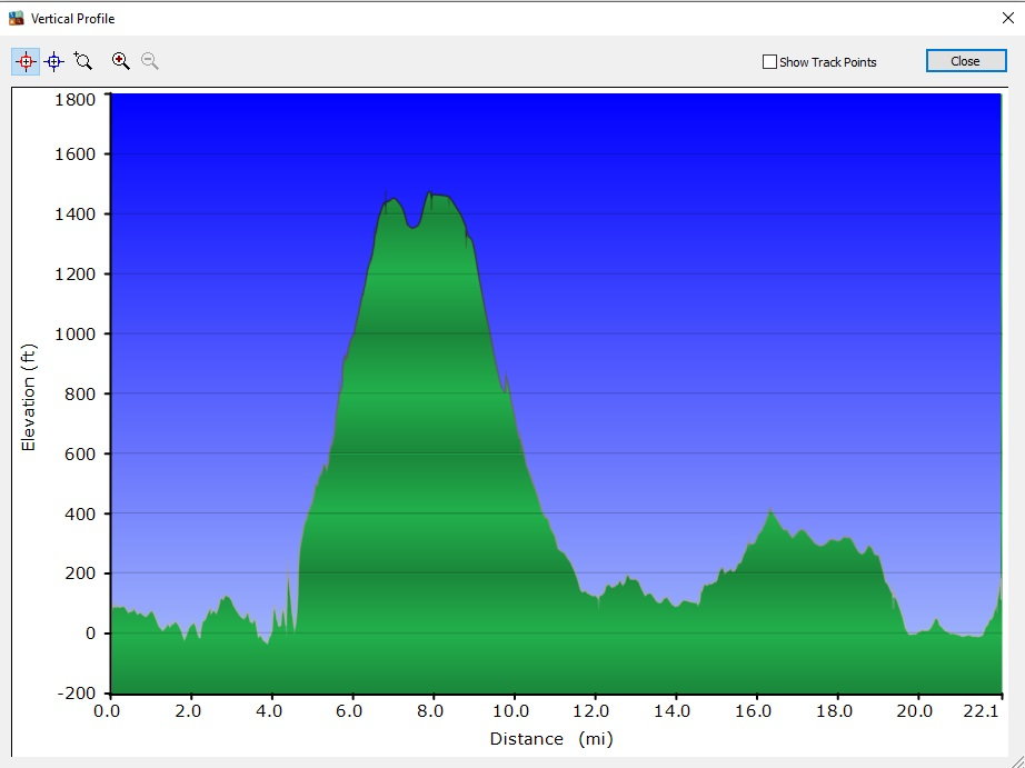
I think you might be over-analyzing this a bit too much. Graphs can look bad when they really are not. This has a CI of 40 (high end of Moderate). The "big climb" you mention at mile 25 seems to be about an overall 400'-500' climb over 25 miles, really not tough at all with a CI of only 20 based on 500' for 25 miles which is much easier than the climbs out of what looks like river valleys valleys around mile 200. To me, the other attention getting areas would be the continual ups and downs around miles 100 and from 175 to say 240 but again those climbs look to be only a couple hundred feet in elevation difference. Sure, they can be gut busters. I can't find the actual route on RWGPS, but overall, it really does not look horrible other than a couple of what looks like to be climbs out of river valleys.
It is fun (to me at least) to review maps, graphs, etc. but remember to look at the relative scale also. I could probably find a graph that looks like a bunch of shark teeth lined up for 25 miles but upon closer look, would realize you are only going up and down 10' or so as ride along a lake shore, road, coast bike path, or eastern Colorado.
One last thing to remember is that a lot of these graphs are not always super accurate, especially in mountainous areas. The data may see the REPORTED elevation (usually by a long-time ago USGS map) but that is really different that a road. For instance, the vast majority of graphs will show a climb when you ride through a tunnel because they see the road as always going on the ground, but not necessarily through a tunnel.
09-23-21, 03:08 PM
#30
Senior Member
Join Date: Aug 2010
Location: Madison, WI
Posts: 11,172
Bikes: 1961 Ideor, 1966 Perfekt 3 Speed AB Hub, 1994 Bridgestone MB-6, 2006 Airnimal Joey, 2009 Thorn Sherpa, 2013 Thorn Nomad MkII, 2015 VO Pass Hunter, 2017 Lynskey Backroad, 2017 Raleigh Gran Prix, 1980s Bianchi Mixte on a trainer. Others are now gone.
Mentioned: 47 Post(s)
Tagged: 0 Thread(s)
Quoted: 3450 Post(s)
Liked 1,449 Times
in
1,130 Posts
I have not used Komoot android app on my phone for a couple years. I am trying to remember, does that show elevation on a proposed route?
09-23-21, 05:05 PM
#31
Senior Member
Join Date: Jan 2010
Posts: 39,205
Mentioned: 211 Post(s)
Tagged: 1 Thread(s)
Quoted: 18395 Post(s)
Liked 15,469 Times
in
7,310 Posts
One last thing to remember is that a lot of these graphs are not always super accurate, especially in mountainous areas. The data may see the REPORTED elevation (usually by a long-time ago USGS map) but that is really different that a road. For instance, the vast majority of graphs will show a climb when you ride through a tunnel because they see the road as always going on the ground, but not necessarily through a tunnel.
In general, I agree there is way too muck over analyzing going on here. Seems more likely to confuse or scare a newb than help.
My first tour was across the country and then some. The Adventure Cycling Maps only had profiles for the western and eastern mountains, and there was no RWGPS or Komoot back then. We still enjoyed ourselves and the surprise we encountered hill-wise.
No offense, but this thread is sort of like the OP offering packing advice to newbs.
Last edited by indyfabz; 09-23-21 at 05:17 PM.
 09-23-21, 06:19 PM
#32
Senior Member
Join Date: Aug 2010
Location: Madison, WI
Posts: 11,172
Bikes: 1961 Ideor, 1966 Perfekt 3 Speed AB Hub, 1994 Bridgestone MB-6, 2006 Airnimal Joey, 2009 Thorn Sherpa, 2013 Thorn Nomad MkII, 2015 VO Pass Hunter, 2017 Lynskey Backroad, 2017 Raleigh Gran Prix, 1980s Bianchi Mixte on a trainer. Others are now gone.
Mentioned: 47 Post(s)
Tagged: 0 Thread(s)
Quoted: 3450 Post(s)
Liked 1,449 Times
in
1,130 Posts
I agree. If the hill is shallow enough to pedal, pedal. If too steep to pedal, then push. Not a lot more analysis is necessary.
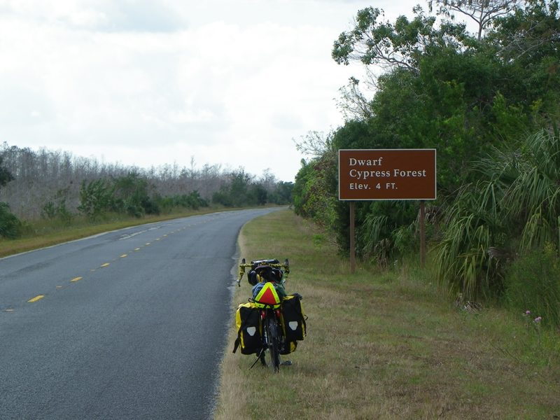
But if the OP really wants to carry a load of hundreds of pounds and use pedal power, maybe all touring should be done in Florida where the only hills are bridge approaches. When I toured Big Cyprus, Everglades and the Keys, I do not think I ever used my granny chainring.
Likes For Tourist in MSN:
09-23-21, 07:51 PM
#33
Full Member
Join Date: Aug 2021
Location: Northeastern Oregon
Posts: 249
Bikes: 2021 Trek Verve 2 Disk
Mentioned: 0 Post(s)
Tagged: 0 Thread(s)
Quoted: 130 Post(s)
Liked 119 Times
in
80 Posts
KC8,
I think you might be over-analyzing this a bit too much. Graphs can look bad when they really are not. This has a CI of 40 (high end of Moderate). The "big climb" you mention at mile 25 seems to be about an overall 400'-500' climb over 25 miles, really not tough at all with a CI of only 20 based on 500' for 25 miles which is much easier than the climbs out of what looks like river valleys valleys around mile 200. To me, the other attention getting areas would be the continual ups and downs around miles 100 and from 175 to say 240 but again those climbs look to be only a couple hundred feet in elevation difference. Sure, they can be gut busters. I can't find the actual route on RWGPS, but overall, it really does not look horrible other than a couple of what looks like to be climbs out of river valleys.
It is fun (to me at least) to review maps, graphs, etc. but remember to look at the relative scale also. I could probably find a graph that looks like a bunch of shark teeth lined up for 25 miles but upon closer look, would realize you are only going up and down 10' or so as ride along a lake shore, road, coast bike path, or eastern Colorado.
One last thing to remember is that a lot of these graphs are not always super accurate, especially in mountainous areas. The data may see the REPORTED elevation (usually by a long-time ago USGS map) but that is really different that a road. For instance, the vast majority of graphs will show a climb when you ride through a tunnel because they see the road as always going on the ground, but not necessarily through a tunnel.
<I assume you meant much, not muck>
I agree. If the hill is shallow enough to pedal, pedal. If too steep to pedal, then push. Not a lot more analysis is necessary.
But if the OP really wants to carry a load of hundreds of pounds and use pedal power, maybe all touring should be done in Florida where the only hills are bridge approaches. When I toured Big Cyprus, Everglades and the Keys, I do not think I ever used my granny chainring.
KC8QVO Started this thread to help answer a question I had after I started another thread. I want to do a trip that I know has a lot of elevation gain so I was wondering how to plan for the trip. I can tell my wife I�m riding around the circumference of the �Eagle Cap Wilderness Area�. Then when I�m not home the next day she would be very upset� and when she tried to call me there wouldn�t be an answer, so more upset� So yes the thread started off great and shows a noobie like me how to set goals based on elevation changes� so for my trip, going 60 miles the first day might be doable with only 400� of elevation gain over the whole 60 miles. Day two starts off grueling with a 2500� elevation gain in 10 miles to flatten out for about 10 more miles before heading down into Hell�s Canyon� there I would descend to my second night only to wake up and have 5,000� of elevation gain in 6 miles. I don�t have to look at the map to know this information� I know it because I�ve walked parts of it, rode motorcycles over some of it, and driven my Jeep over most of it. So yes, Stephen did an excellent job helping me realize that doing my trip in 2 days that I had originally planned was a very ambitious goal. I think I need to plan about a week for my ride because I want down time to hunt, fish, and play radio, as well as just staring off in my own thoughts.
Just as KC8QVO I too will be loaded heavier than most people because radios aren�t light. But the fun of making a contact at the top of a class 10 peak is well worth the effort� 30 of em and it�s icing on the cake.
Likes For M Rose:
09-23-21, 08:06 PM
#34
Full Member
Join Date: Sep 2005
Location: Tulsa, OK
Posts: 451
Bikes: Co-Motion Americano Pinion P18; Co-Motion Americano Rohloff; Thorn Nomad MkII, Robert Beckman Skakkit (FOR SALE), Santana Tandem, ICE Adventure FS
Mentioned: 1 Post(s)
Tagged: 0 Thread(s)
Quoted: 169 Post(s)
Liked 64 Times
in
48 Posts
[QUOTE=M Rose;22243473.... there I would descend to my second night only to wake up and have 5,000� of elevation gain in 6 miles. I don�t have to look at the map to know this information�... So yes, Stephen did an excellent job .....[/QUOTE]
My point, which may not have come across as friendly as it was meant, was that sometimes we can over analyze stuff too much. I am guilty of it also. Lord, help me when I try to decide to buy a new car, tent, etc. Months can go pass due to me analyzing every possibility and every facet. I sincerely apologize if I came across as rude or trying to shut him down. It was definitely not my intention.
That said, out of curiosity, can you show me specifically where you will climb 5k feet in 6 miles? That is definitely a massive climb with a CI of 833+. And that is assuming an average grade. I just want to know so that I never ride my bike up it. Even going down it might be a literal pain due to squeezing the brakes so much if the road was the least bit twisty which I assume it would have to be. If it is straight, I definitely want to go down it and see if I can break my 52mph record.
Tailwinds, John
Likes For John N:
09-24-21, 01:27 AM
#35
Full Member
Join Date: Aug 2021
Location: Northeastern Oregon
Posts: 249
Bikes: 2021 Trek Verve 2 Disk
Mentioned: 0 Post(s)
Tagged: 0 Thread(s)
Quoted: 130 Post(s)
Liked 119 Times
in
80 Posts
My point, which may not have come across as friendly as it was meant, was that sometimes we can over analyze stuff too much. I am guilty of it also. Lord, help me when I try to decide to buy a new car, tent, etc. Months can go pass due to me analyzing every possibility and every facet. I sincerely apologize if I came across as rude or trying to shut him down. It was definitely not my intention.
That said, out of curiosity, can you show me specifically where you will climb 5k feet in 6 miles? That is definitely a massive climb with a CI of 833+. And that is assuming an average grade. I just want to know so that I never ride my bike up it. Even going down it might be a literal pain due to squeezing the brakes so much if the road was the least bit twisty which I assume it would have to be. If it is straight, I definitely want to go down it and see if I can break my 52mph record.
Tailwinds, John
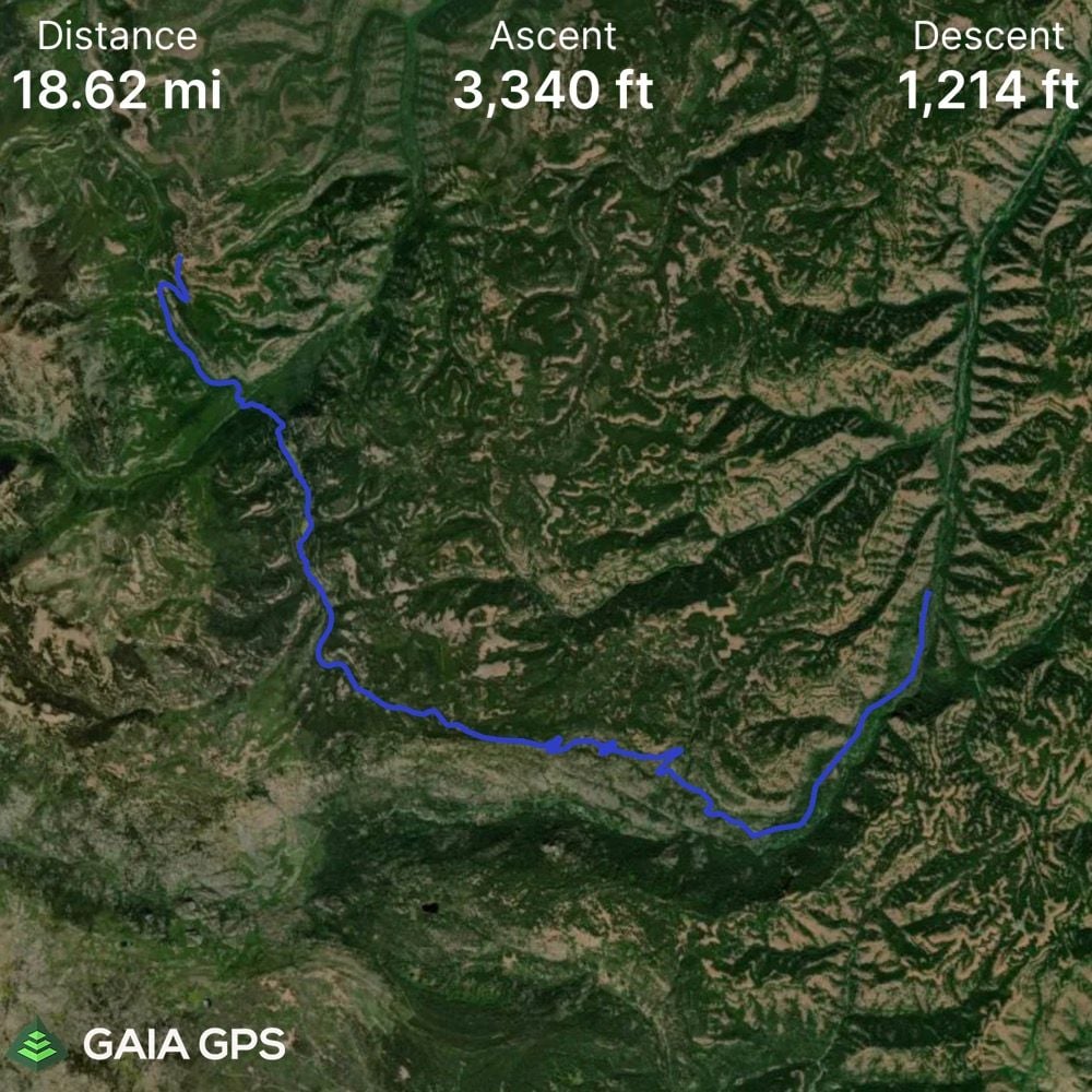
https://www.gaiagps.com/public/VldQK64yVULFYpcA70qwXbg0
https://www.gaiagps.com/public/UeeosUzh68fJbXsvxFxt9POM
I don�t know how to post GPX files here.
I could do the whole loop clockwise instead of counterclockwise which would put 90% or the trip downhill, with a steady incline for the fist 2 days and then the rest of the trip could be done in 1 day as it would be more drop than gain� but� where is the fun in that. And it would put me at each River at the wrong time of day for fishing. And lastly I wouldn�t be able to do my radio stuff until Day 2, instead of during the whole trip.
John N i too over analyze everything. Shoot, it took me 5 years to buy my first �Real� Bike, and even then I chose the wrong one� but in my defense, I didn�t think my body would be able to handle the geometry of a road bike, so scratched off all the gravel/road bikes without even a thought. After my first 40 mile ride on my comfort bike I quickly realized I need an endurance bike.
I will probably be doing my trip on a Trek Verve 2 Disk as my dream bike won�t be in my financial future until the beginning of 2022. If weather holds out, I want to take the journey next weekend in order to miss the end of deer season and the beginning of Elk season� otherwise I�ll be holding out until next spring.
Last edited by M Rose; 09-24-21 at 01:43 AM.
09-24-21, 03:18 AM
#36
Senior Member
Join Date: Aug 2010
Location: Madison, WI
Posts: 11,172
Bikes: 1961 Ideor, 1966 Perfekt 3 Speed AB Hub, 1994 Bridgestone MB-6, 2006 Airnimal Joey, 2009 Thorn Sherpa, 2013 Thorn Nomad MkII, 2015 VO Pass Hunter, 2017 Lynskey Backroad, 2017 Raleigh Gran Prix, 1980s Bianchi Mixte on a trainer. Others are now gone.
Mentioned: 47 Post(s)
Tagged: 0 Thread(s)
Quoted: 3450 Post(s)
Liked 1,449 Times
in
1,130 Posts
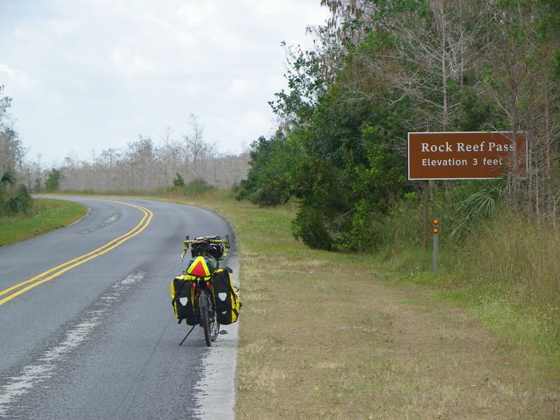
The photo I posted with the 13 percent grade, I knew about that hill in my early planning of that trip, long before I got on the airplane and went through customs to get there. It was supposed to be very scenic, but this is what the top looked like:
 09-24-21, 10:26 AM
#37
Senior Member
Thread Starter
Join Date: Apr 2013
Posts: 1,173
Bikes: Surly Disk Trucker, 2014 w/Brooks Flyer Special saddle, Tubus racks - Duo front/Logo Evo rear, 2019 Dahon Mariner D8, Both bikes share Ortlieb Packer Plus series panniers, Garmin Edge 1000
Mentioned: 2 Post(s)
Tagged: 0 Thread(s)
Quoted: 405 Post(s)
Liked 115 Times
in
99 Posts
KC8QVO Started this thread to help answer a question I had after I started another thread. I want to do a trip that I know has a lot of elevation gain so I was wondering how to plan for the trip.
The first thing I want to say about trip planning and analyzing numbers is everyone's numbers are different. These are mine, and that is the only person they may pertain to. Your numbers will likely be different - and it is up to you to find those. Everyone's gear is different - bikes are different, tires are different, crank sets are different, and whether you load everything on your bike or pull a trailer varies, the trailer set up, etc. So you can't just apply a "cookie cutter" set of numbers and expect any accuracy of difficulty or ease of ride vs fitness level. There are way too many variables.
Therein lies the million dollar question - especially with less experienced riders. With all the variables how do you know where to even begin to understand your specific numbers?
Therein lies the million dollar question - especially with less experienced riders. With all the variables how do you know where to even begin to understand your specific numbers?
Lastly, my intent with this is an illustration of my thought process and how I am looking at route planning to give others ideas on how they can approach route planning. This isn't a bash contest, nor should it start one.
Happy riding! Sometimes the journey is the destination. So don't necessarily get hung up on your "numbers" - there is always a way through, it might just take longer than you anticipate. Ride your own ride.
Happy riding! Sometimes the journey is the destination. So don't necessarily get hung up on your "numbers" - there is always a way through, it might just take longer than you anticipate. Ride your own ride.
The Climbing Index John mentioned is also an excellent reference point - one I may start incorporating in my analysis and route plans going forward.
For those that are starting out - if they have no base line yet - where do they start? The ideas here should get them well on their way to that track. There is no "bad advice" in that. My "numbers" (reference the rest of the thread) might just not be anyone else's numbers and none of us can tell anyone else what anyone's numbers should be at any given point in time. That would be "bad advice".
Likes For KC8QVO:
09-24-21, 08:58 PM
#38
Full Member
With the greatest of respect to the OP, touring by numbers is only one way to tour and would not be my way of touring. Getting away from numbers is why I tour.
I toured merrily for years without ever once thinking of looking at an elevation profile (nor a gps). There were a couple of Alp crossings and a lot of hilly Northern Spain in there too. In comparison to most here I travel heavy.
I've recently changed my attitude, but that's more to do with a combination of heat, humidity and climbing. 2000 meters over 80km in 40C is a bit different to what I'm used to. And I'm getting older.
I use Osmand and find it gives accurate data, online or off. It's graphs are useful.
09-25-21, 04:57 AM
#39
Senior Member
For someone starting touring, in my opinion doing some rides with your bike loaded and even using something simple like Google maps that can show the metres gainedin the ride, will at least start to give the person a good rough idea of how to expect a days ride.
re the over analyzing thing, I'm sure part of for KC is that he carries so much weight on and behind his bike on his trailer that the impact of climbing is just plain bonkers compared to a bike tourist carrying 40, 30 or 20lbs.
it's like comparing riders on a loaded touring bike vs a pro racer on a 6.7kg bike, just totally different experience.
KC's experience is very unique, and he won't change, but the general idea is good to use technology to get an idea of a days ride, in this case for new tourers, it does have to be emphasized that his situation is at the extreme, and for the vast majority of tourers things do work out with less attention to every detail of potentially confusing graphs etc.
it is really neat though how we have access to such neat tools now for route planning, with the caution of over analyzing up the ying yang internet stuff and just simply getting out there for an adventure.
Likes For djb:
09-27-21, 12:20 PM
#40
Senior Member
Join Date: Jan 2010
Posts: 39,205
Mentioned: 211 Post(s)
Tagged: 1 Thread(s)
Quoted: 18395 Post(s)
Liked 15,469 Times
in
7,310 Posts
Analyze this:
VERMONT-PHILLY 2021 ACTUAL - A bike ride in Saint Albans, VT (ridewithgps.com)
Nor included is the day riding I did in and around Burlington, VT and Hyde Park, NY, nor mileage inside campgrounds. Odometer, which was at 0 when I left the house to ride to the train station, and which was spot on accurate according to road mile markers, read 650.
While 49'/mile is what I would call moderately hilly, the healthy number of trail miles incorporated into the route makes that number misleading. That's why I believe you have to look "through" the numbers.
09-27-21, 12:59 PM
#41
Senior Member
Thread Starter
Join Date: Apr 2013
Posts: 1,173
Bikes: Surly Disk Trucker, 2014 w/Brooks Flyer Special saddle, Tubus racks - Duo front/Logo Evo rear, 2019 Dahon Mariner D8, Both bikes share Ortlieb Packer Plus series panniers, Garmin Edge 1000
Mentioned: 2 Post(s)
Tagged: 0 Thread(s)
Quoted: 405 Post(s)
Liked 115 Times
in
99 Posts
Analyze this:
VERMONT-PHILLY 2021 ACTUAL - A bike ride in Saint Albans, VT (ridewithgps.com)
Nor included is the day riding I did in and around Burlington, VT and Hyde Park, NY, nor mileage inside campgrounds. Odometer, which was at 0 when I left the house to ride to the train station, and which was spot on accurate according to road mile markers, read 650.
For ease of reference here, and without a screen shot (check the link for the rest of the details) - the "numbers" are ~589 miles and ~28,800ft elevation gain.
Knowing my history and my "numbers" that route would be absolutely bonkers to attempt. Even if I trimmed down to travel light (to the extreme for me) I would hesitate with that kind of traveling in the mountains. A test ride would be in order, for sure, to recalibrate "numbers".
Looking at the elevation graph in the link - there are some massive climbs. I believe the grades in the data set on the left are the maximums (max incline, max decline)? If so - over 20% on a climb is wicked. I recall from ride #3 in the example I gave in the 1st or 2nd post the grade, to me at the time, was wicked and the highest grade I found in the data on my Strava record for it was a hair over 16%. So 20% is that much more. If I had to get through an area like that I would probably have to split gear and make a few trips
 09-27-21, 01:41 PM
#42
Senior Member
Join Date: Dec 2010
Location: northern Deep South
Posts: 8,889
Bikes: Fuji Touring, Novara Randonee
Mentioned: 36 Post(s)
Tagged: 0 Thread(s)
Quoted: 2590 Post(s)
Liked 1,920 Times
in
1,204 Posts
09-27-21, 01:46 PM
#43
Senior Member
Join Date: Jan 2010
Posts: 39,205
Mentioned: 211 Post(s)
Tagged: 1 Thread(s)
Quoted: 18395 Post(s)
Liked 15,469 Times
in
7,310 Posts
Are you referring to the "climbing index" result you got (the 49'/mile) as the "number" that should be looked through? If so I think that is a good parallel to the point I was describing here.
Looking at the elevation graph in the link - there are some massive climbs. I believe the grades in the data set on the left are the maximums (max incline, max decline)? If so - over 20% on a climb is wicked. I recall from ride #3 in the example I gave in the 1st or 2nd post the grade, to me at the time, was wicked and the highest grade I found in the data on my Strava record for it was a hair over 16%. So 20% is that much more. If I had to get through an area like that I would probably have to split gear and make a few trips
Looking at the elevation graph in the link - there are some massive climbs. I believe the grades in the data set on the left are the maximums (max incline, max decline)? If so - over 20% on a climb is wicked. I recall from ride #3 in the example I gave in the 1st or 2nd post the grade, to me at the time, was wicked and the highest grade I found in the data on my Strava record for it was a hair over 16%. So 20% is that much more. If I had to get through an area like that I would probably have to split gear and make a few trips
I had to push the bike up that ruling grade for a bit. It was warm and very humid, and the Berkshires are no joke. I have done D2R2, which is a one-day, mostly dirt randonee-type ride that starts in Deerfield, MA (where I went to high school and where I passed through on this trip) and goes into VT for a while. I did the metric route. That year it had close to 8,000' of climbing.
Likes For indyfabz:
09-27-21, 03:03 PM
#44
Senior Member
Join Date: Aug 2010
Location: Madison, WI
Posts: 11,172
Bikes: 1961 Ideor, 1966 Perfekt 3 Speed AB Hub, 1994 Bridgestone MB-6, 2006 Airnimal Joey, 2009 Thorn Sherpa, 2013 Thorn Nomad MkII, 2015 VO Pass Hunter, 2017 Lynskey Backroad, 2017 Raleigh Gran Prix, 1980s Bianchi Mixte on a trainer. Others are now gone.
Mentioned: 47 Post(s)
Tagged: 0 Thread(s)
Quoted: 3450 Post(s)
Liked 1,449 Times
in
1,130 Posts
When you are looking at on-line grades for routing, sometimes the computer pulls numbers off a map and plotted up a graph without a good basis in reality.
A friend of mine was proposing a route. I converted his GPS format to whatever format Google Earth would take and put it into Google Earth. It gave me some crazy elevation data. Eventually I figured out that the GPS route was simply a series of lat and long points in a computer data base. And the computer also have elevation data which it used to plot the elevation plot. What went wrong was that the road followed the bottom of a cliff, and Google Earth at times used the elevation at the top of the cliff, sometimes at the bottom of the cliff. Needless to say, that was the weirdest elevation profile I have ever seen.
Bottom line, where you have steep grades, you have to ask yourself, how accurate is that data?
But if you are in Florida, it probably gives you great elevation data.
Likes For Tourist in MSN:
Likes For djb:
09-27-21, 05:12 PM
#46
Senior Member
Join Date: Aug 2010
Location: Madison, WI
Posts: 11,172
Bikes: 1961 Ideor, 1966 Perfekt 3 Speed AB Hub, 1994 Bridgestone MB-6, 2006 Airnimal Joey, 2009 Thorn Sherpa, 2013 Thorn Nomad MkII, 2015 VO Pass Hunter, 2017 Lynskey Backroad, 2017 Raleigh Gran Prix, 1980s Bianchi Mixte on a trainer. Others are now gone.
Mentioned: 47 Post(s)
Tagged: 0 Thread(s)
Quoted: 3450 Post(s)
Liked 1,449 Times
in
1,130 Posts
Likes For Tourist in MSN:
09-27-21, 06:34 PM
#47
Senior Member
Thread Starter
Join Date: Apr 2013
Posts: 1,173
Bikes: Surly Disk Trucker, 2014 w/Brooks Flyer Special saddle, Tubus racks - Duo front/Logo Evo rear, 2019 Dahon Mariner D8, Both bikes share Ortlieb Packer Plus series panniers, Garmin Edge 1000
Mentioned: 2 Post(s)
Tagged: 0 Thread(s)
Quoted: 405 Post(s)
Liked 115 Times
in
99 Posts
10-05-21, 05:28 PM
#48
Banned
My first 1000 mile road trip I did with a bike carrying 25 lbs of gear. Every trip since then I have carried less than 20 lbs and if staying at hotels and inns my bike baggage weighs less than 15 lbs. Elevation gain is what it is and at least with a grade any effort I make going up is returned to me on the downhill side. I have found very long downgrades much more of a pain and so I avoid them if possible. Wind is another factor and in North America the prevailing wind direction is from the northwest unless a storm front is passing through. I prefer to have the wind at my back as much as possible as it makes a great deal of difference in my miles per day covered on a trip.
I adjust my planned stops based on the degree of difficulty. Not difficult to average 100 plus miles along the California coast but difficult to bike 70 miles a day going through the mountains. I also allow time to reach my stop over point before the light starts to fade and put me more at risk of being hit from behind by an approaching motorist.
Road conditions are also a factor in my safety on a bicycle and places that were relatively safe in the 1970's are now very dangerous by bicycles and these days we have a lot more inattentive drivers focused on their smartphones and paying little attention to where they are driving.
05-03-22, 07:16 PM
#49
Senior Member
Thread Starter
Join Date: Apr 2013
Posts: 1,173
Bikes: Surly Disk Trucker, 2014 w/Brooks Flyer Special saddle, Tubus racks - Duo front/Logo Evo rear, 2019 Dahon Mariner D8, Both bikes share Ortlieb Packer Plus series panniers, Garmin Edge 1000
Mentioned: 2 Post(s)
Tagged: 0 Thread(s)
Quoted: 405 Post(s)
Liked 115 Times
in
99 Posts
When I spoke somewhat in depth about the data with the Strava marketing team at an international transportation convention about 3 or 4 years ago, they said then the data was updated yearly on a once-per-year basis. You have to remember that their original company was to supply governments with "pedestrian" data for which the government agency uses to decide where to put in bike lanes, bike signs, hiking trails, sidewalks, etc. so they need to keep the data somewhat current. The company definitely has evolved into a more user focused company, a la RWGPS, since they now can get a good chunk of income from the users. I would guess the overall data is still probably customized and sold to governments who want it. Anyway, I "think" I have read since then that the data is now on a rolling 2-year basis updated every 3 months (the data is up to 27 months old) but I am definitely not positive about that. I know from my route research over the years that new data is put rotated in/out. I have not tracked on what frequency but could easily believe it is at least once per year if not more often.

So there ya have it.
Strava is updated monthly and is a rolling period of 1 year's worth of data.
I can appreciate their respecting users "private data". In all honesty, I keep mine private. My reasoning for that is I am not on Strava to find others to ride with, share ride metrics with other users, compete with others' rides, nor have others compete with my rides.
However, those are known/specific uses of the data and can be drilled down to a known source.
Anonymized data isn't quite the same. For example - I wouldn't mind if my data went in to the heat map. I just don't want the community uses/followers.
In any event, from what it appears - the only data that appears in the "Heat Map" is from "public users" that do freely share their data - which may be a significantly smaller percentage of Strava users, and may also skew the routes.
Likes For KC8QVO:


