


last ride of your life...
 10-13-20, 04:19 AM
#1
velo-dilettante
Thread Starter
Join Date: Apr 2009
Location: insane diego, california
Posts: 8,315
Bikes: 85 pinarello treviso steel, 88 nishiki olympic steel. 95 look kg 131 carbon, 11 trek madone 5.2 carbon
Mentioned: 26 Post(s)
Tagged: 0 Thread(s)
Quoted: 1627 Post(s)
Liked 3,113 Times
in
1,683 Posts
last ride of your life...
so you've got one socal ride left in your life. you've got all day and a perfect, responsive machine. forget about temperature/daylight/traffic/current physical limitations/concerns.
you've got up to 125 miles if you wanna jack it up that far. don't worry about transportation, car shuttles, train schedules. you're getting dropped off and picked up.
you're in decent enuff shape to ride anything and anywhere in socal. where are you going for that last spin? tell us about it and why. what road(s) would you regret not hitting?
Last edited by diphthong; 10-13-20 at 01:27 PM.

Likes For diphthong:
10-13-20, 09:24 AM
#2
Full Member
Easy peasy! Hwy 1. Start at Ft. Bragg and head south till I've clicked off 125 miles. Done it by car & motorcycle someday I'll pedal it.
West
Edit: sorry just noticed you said "socal ride" so my answer doesn't qualify but it'd still be my choice! Socal would be Mulholland end to end.
West
Edit: sorry just noticed you said "socal ride" so my answer doesn't qualify but it'd still be my choice! Socal would be Mulholland end to end.
Last edited by 2seven0; 10-13-20 at 09:40 AM.
Likes For 2seven0:
10-13-20, 10:04 AM
#3
Senior Member
Join Date: May 2017
Location: Hacienda Hgts
Posts: 2,102
Bikes: 1999 Schwinn Peloton Ultegra 10, Kestrel RT-1000 Ultegra, Trek Marlin 6 Deore 29'er
Mentioned: 3 Post(s)
Tagged: 0 Thread(s)
Quoted: 822 Post(s)
Liked 1,955 Times
in
941 Posts
I have my eyes and legs aimed for an Encanto Park to Wrightwood out and back for awhile.
https://ridewithgps.com/routes/34408622
I could actually see Dawson Saddle this morning so the air is better. Probably cannot say the same for the forest. I imagine a lot of it is charred from the Bobcat Fire along Hwy 39 and SR-2?
https://ridewithgps.com/routes/34408622
I could actually see Dawson Saddle this morning so the air is better. Probably cannot say the same for the forest. I imagine a lot of it is charred from the Bobcat Fire along Hwy 39 and SR-2?
Likes For CAT7RDR:
10-13-20, 10:58 AM
#4

well hello there

Join Date: May 2005
Location: Point Loma, CA
Posts: 15,430
Bikes: Bill Holland (Road-Ti), Fuji Roubaix Pro (back-up), Bike Friday (folder), Co-Motion (tandem) & Trek 750 (hybrid)
Mentioned: 6 Post(s)
Tagged: 0 Thread(s)
Quoted: 503 Post(s)
Liked 336 Times
in
206 Posts

My favorite ride in So Cal is Kitchen Creek. No where near 125 miles. But that's what makes it so fantastic. I think you get about 4,000 vertical feet in less than 15 miles.
__________________
.
.
Two wheels good. Four wheels bad.
.
.
Two wheels good. Four wheels bad.
Likes For Nachoman:
10-14-20, 11:44 PM
#5
velo-dilettante
Thread Starter
Join Date: Apr 2009
Location: insane diego, california
Posts: 8,315
Bikes: 85 pinarello treviso steel, 88 nishiki olympic steel. 95 look kg 131 carbon, 11 trek madone 5.2 carbon
Mentioned: 26 Post(s)
Tagged: 0 Thread(s)
Quoted: 1627 Post(s)
Liked 3,113 Times
in
1,683 Posts
8 fwy/ca hwy 79 parking lot to kitchen creek up to sunrise highway is roughly 30 miles and 4,600 feet el gain. base of kitchen creek to mt. laguna store is roughly 15 miles and 3,200 ft el gain. nice.
10-15-20, 12:45 AM
#6
Banned.
Join Date: Sep 2007
Location: Carlsbad, CA
Posts: 6,434
Bikes: '09 Felt F55, '84 Masi Cran Criterium, (2)'86 Schwinn Pelotons, '86 Look Equippe Hinault, '09 Globe Live 3 (dogtaxi), '94 Greg Lemond, '99 GT Pulse Kinesis
Mentioned: 19 Post(s)
Tagged: 0 Thread(s)
Quoted: 389 Post(s)
Liked 269 Times
in
153 Posts
Don't care if it's one mile or 125, if it's on a deserted PCH early on a Tuesday morning or rush-hour in OC, every ride with my little Biscuitbutt is like the last precious breath in my airhose.


Drafted her the entire 25 mile ride today and she never complained.

Drafted her the entire 25 mile ride today and she never complained.
Last edited by calamarichris; 10-15-20 at 12:56 AM.
10-15-20, 12:53 AM
#7
velo-dilettante
Thread Starter
Join Date: Apr 2009
Location: insane diego, california
Posts: 8,315
Bikes: 85 pinarello treviso steel, 88 nishiki olympic steel. 95 look kg 131 carbon, 11 trek madone 5.2 carbon
Mentioned: 26 Post(s)
Tagged: 0 Thread(s)
Quoted: 1627 Post(s)
Liked 3,113 Times
in
1,683 Posts
10-15-20, 01:55 AM
#8
Banned.
Join Date: Sep 2007
Location: Carlsbad, CA
Posts: 6,434
Bikes: '09 Felt F55, '84 Masi Cran Criterium, (2)'86 Schwinn Pelotons, '86 Look Equippe Hinault, '09 Globe Live 3 (dogtaxi), '94 Greg Lemond, '99 GT Pulse Kinesis
Mentioned: 19 Post(s)
Tagged: 0 Thread(s)
Quoted: 389 Post(s)
Liked 269 Times
in
153 Posts
Alas, no.
1 - Carlsbad, El Autobahn Real, just up the hill from my home
2 - Kate Sessions Park (we've become park aficionados since I got furloughed, and I've proud to say I've picked up nearly a thousand pounds of trash in parks since the covid hit the fan.
3 - Carlsbad, on our way home from a 60-mile ride with my comrade Jimmy from New Hampshire (I think). If it isn't too late, I'd like for Tovareetch Jimmy to come along on my final ride too please. (Dudes' nuts.)
Likes For calamarichris:
10-15-20, 03:10 AM
#9
velo-dilettante
Thread Starter
Join Date: Apr 2009
Location: insane diego, california
Posts: 8,315
Bikes: 85 pinarello treviso steel, 88 nishiki olympic steel. 95 look kg 131 carbon, 11 trek madone 5.2 carbon
Mentioned: 26 Post(s)
Tagged: 0 Thread(s)
Quoted: 1627 Post(s)
Liked 3,113 Times
in
1,683 Posts
Alas, no.
1 - Carlsbad, El Autobahn Real, just up the hill from my home
2 - Kate Sessions Park (we've become park aficionados since I got furloughed, and I've proud to say I've picked up nearly a thousand pounds of trash in parks since the covid hit the fan.
3 - Carlsbad, on our way home from a 60-mile ride with my comrade Jimmy from New Hampshire (I think). If it isn't too late, I'd like for Tovareetch Jimmy to come along on my final ride too please. (Dudes' nuts.)
headwind back to the irvine train station up the 133/laguna cyn corridor and he mysteriously disappeared and maybe a few months before/after that when he and i and like 3 other bike forums dingdongs decided to
crash (not crush) a palomar mtn south grade ride on the weekend. bad idea. good execution. he ripped my legs off near the top of the first big segment before the flat. bastardo. otherwise, he seemed like a genuinely
nice and normal guy. i could be wrong, as usual, but hoping i'm wrong about that. we knead another bf ride. maybe north county sd? i would be honored for jimmy to be along for the ride/destroying the pack on my
last socal ride...prob in the sammos but jimmy admittedly not a fan of the sammos...
nice point loma/cabrillo natl monument pic btw...
Last edited by diphthong; 10-15-20 at 03:20 AM.
Likes For diphthong:
10-15-20, 11:27 AM
#10

Senior Member
No idea who this jimmy character is, but I am already not a fan
We have some great riding in our parts, but my last ride of my life would not be here. Either the Alps or Cape Town. If it had to be here, it would be the Sammos.
We have some great riding in our parts, but my last ride of my life would not be here. Either the Alps or Cape Town. If it had to be here, it would be the Sammos.
10-15-20, 12:45 PM
#11
Sophomore Member

Join Date: Jan 2019
Posts: 2,531
Mentioned: 12 Post(s)
Tagged: 0 Thread(s)
Quoted: 1628 Post(s)
Liked 1,057 Times
in
631 Posts
The premise of the thread reminds me of an old TV series about a guy given a terminal diagnosis, "I guess I'll have to squeeze thirty years of living, into one or two ..." (if the show isn't cancelled the first season)
I would need to see some Sequoia trees on my last ride, so I'm thinking "General's Highway". Here is an excellent guide to riding there: https://pjammcycling.com/zone/236.Sequoia-National-Park
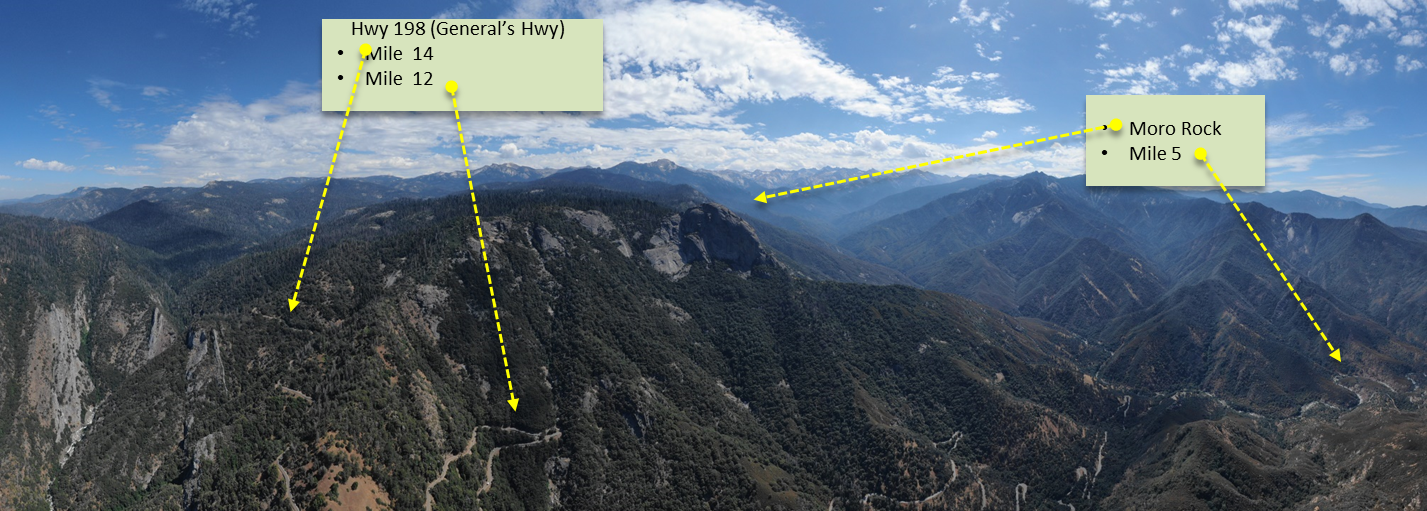
The aerial shot gives you some idea of how windy a road it is, with countless switchbacks. It tops out around 7700 feet, and where I start from, is a non-stop 20+ mile HC climb. Yes, climbing for 20 miles non-stop. There are many climbs like that in the Sierras, to climb for that long, you need a mountain at least 6 or 7 thousand feet tall.
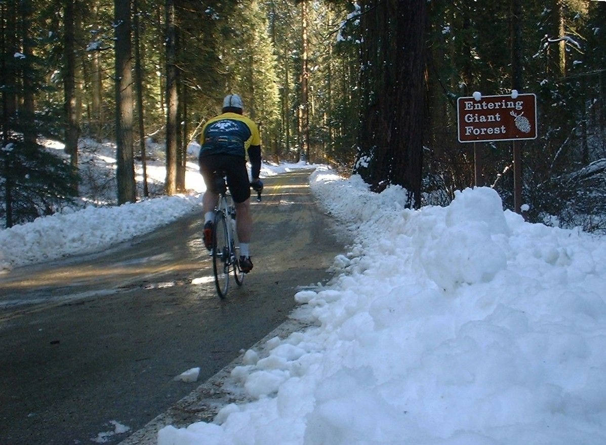
I like to go right after a snow, when the roads have just been cleared. March and April are good months for that. That's me on my Bottecchia (which was later stolen) from 2000 or so.

Not my pic, but makes a good comparison between seasons in the same spot.
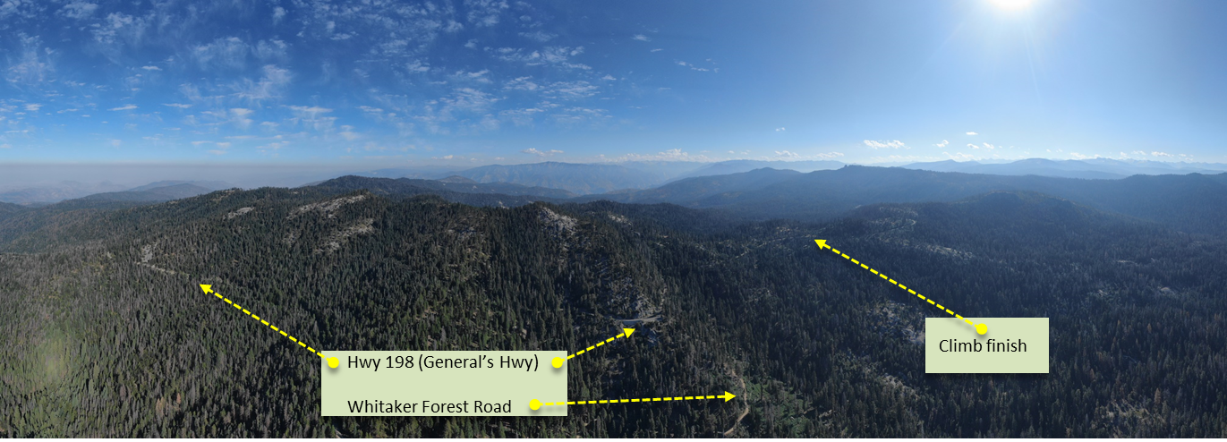
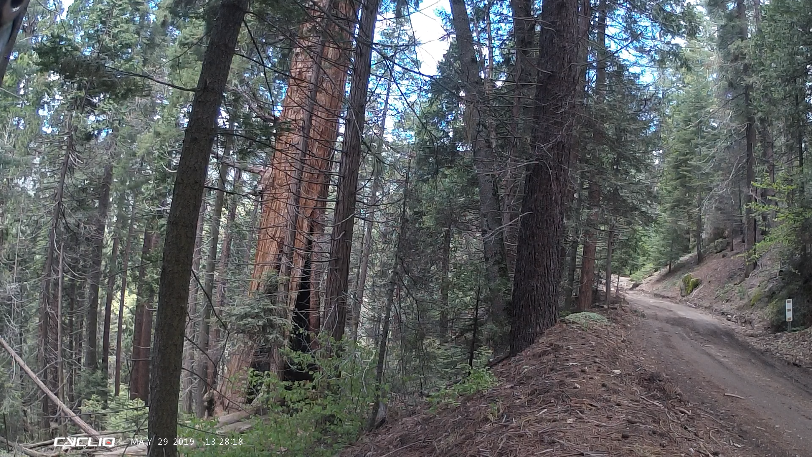
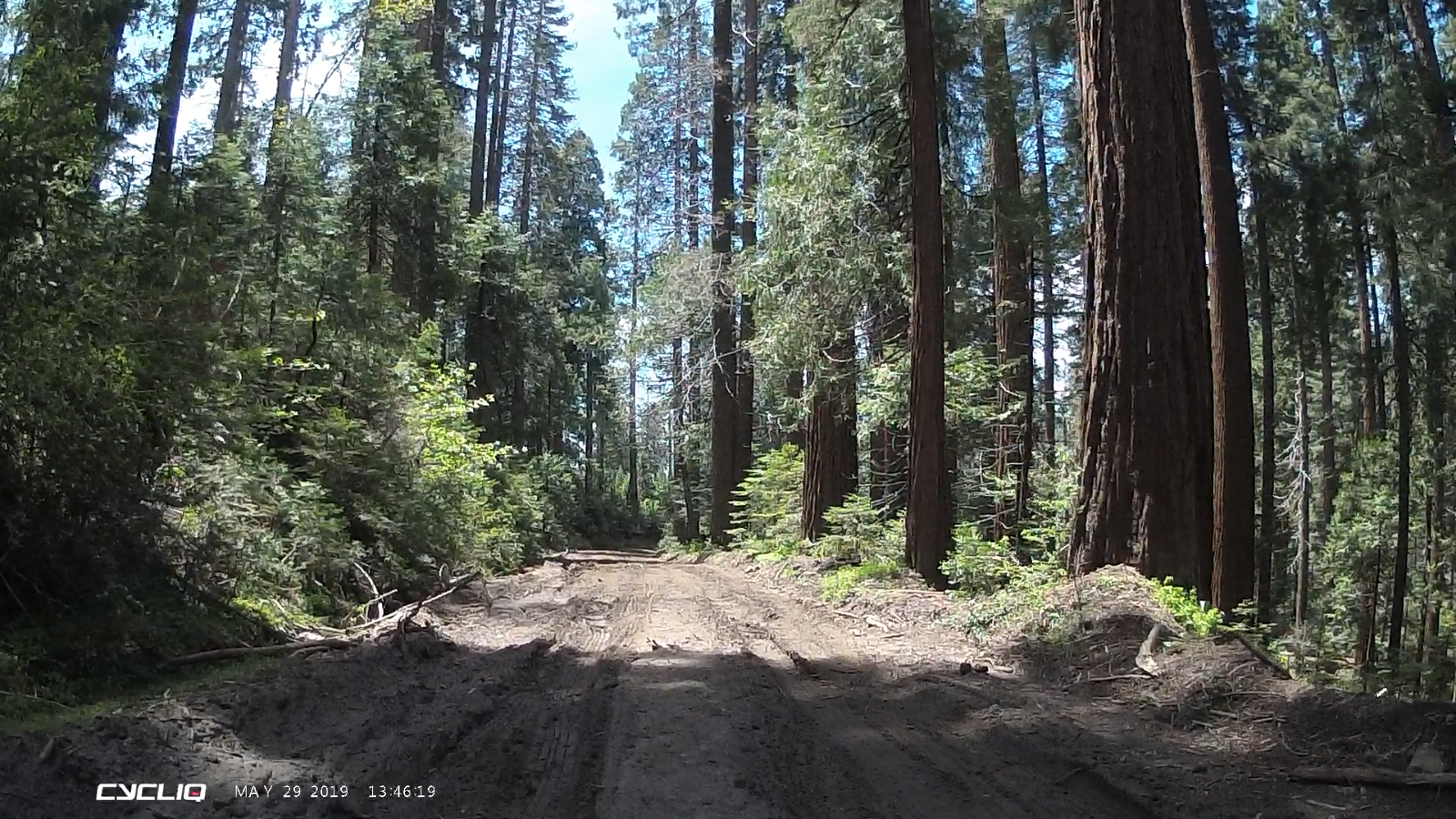
Whitaker Forest Road is a great dirt road route to the same area of Sequoia National Park, I think incorporating parts of that ride would be good: https://pjammcycling.com/climb/87.Whitaker-Forest
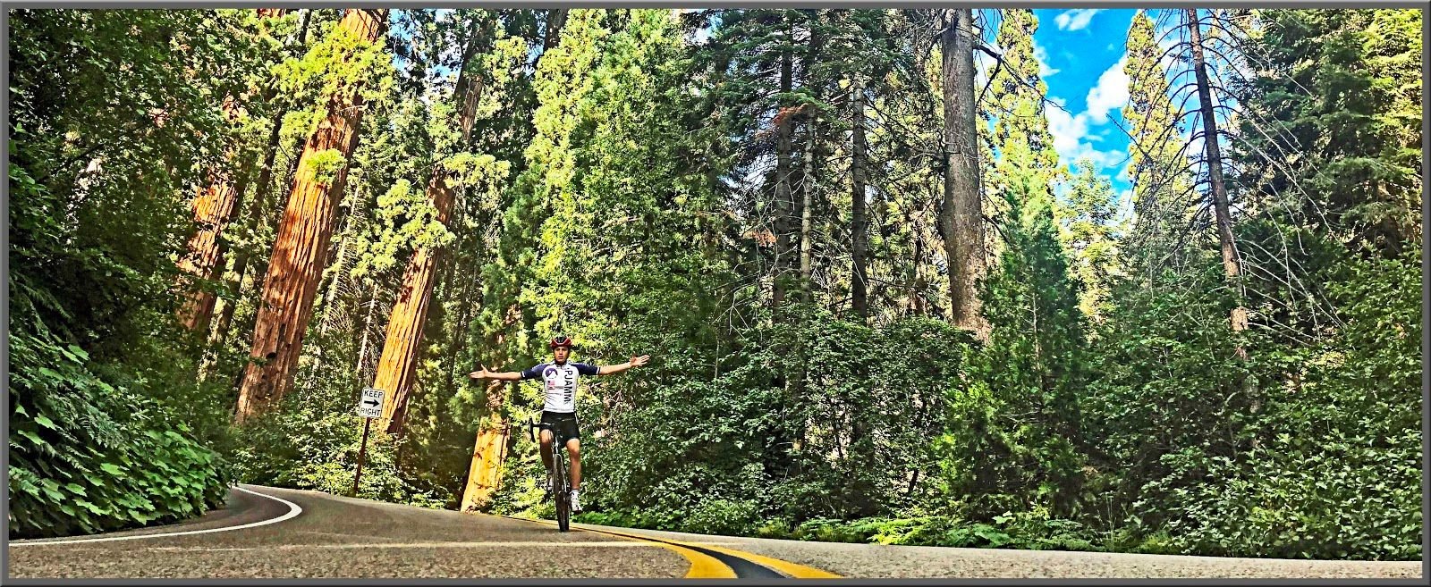
Not my pic, but the feeling you get when you're up there is pretty universal.
I think Mt. Tamalpais would be my second choice, except it's not in So Cal.
Found some shots of the unpaved portion of Whitaker Forest Road:

I would need to see some Sequoia trees on my last ride, so I'm thinking "General's Highway". Here is an excellent guide to riding there: https://pjammcycling.com/zone/236.Sequoia-National-Park
The aerial shot gives you some idea of how windy a road it is, with countless switchbacks. It tops out around 7700 feet, and where I start from, is a non-stop 20+ mile HC climb. Yes, climbing for 20 miles non-stop. There are many climbs like that in the Sierras, to climb for that long, you need a mountain at least 6 or 7 thousand feet tall.
I like to go right after a snow, when the roads have just been cleared. March and April are good months for that. That's me on my Bottecchia (which was later stolen) from 2000 or so.
Not my pic, but makes a good comparison between seasons in the same spot.
Whitaker Forest Road is a great dirt road route to the same area of Sequoia National Park, I think incorporating parts of that ride would be good: https://pjammcycling.com/climb/87.Whitaker-Forest
Not my pic, but the feeling you get when you're up there is pretty universal.
I think Mt. Tamalpais would be my second choice, except it's not in So Cal.
Found some shots of the unpaved portion of Whitaker Forest Road:
Last edited by Lemond1985; 10-15-20 at 03:06 PM.
10-16-20, 02:42 AM
#12
velo-dilettante
Thread Starter
Join Date: Apr 2009
Location: insane diego, california
Posts: 8,315
Bikes: 85 pinarello treviso steel, 88 nishiki olympic steel. 95 look kg 131 carbon, 11 trek madone 5.2 carbon
Mentioned: 26 Post(s)
Tagged: 0 Thread(s)
Quoted: 1627 Post(s)
Liked 3,113 Times
in
1,683 Posts
The premise of the thread reminds me of an old TV series about a guy given a terminal diagnosis, "I guess I'll have to squeeze thirty years of living, into one or two ..." (if the show isn't cancelled the first season)
https://www.youtube.com/watch?v=B8Foo4JKblM
I would need to see some Sequoia trees on my last ride, so I'm thinking "General's Highway". Here is an excellent guide to riding there: https://pjammcycling.com/zone/236.Sequoia-National-Park
The aerial shot gives you some idea of how windy a road it is, with countless switchbacks. It tops out around 7700 feet, and where I start from, is a non-stop 20+ mile HC climb. Yes, climbing for 20 miles non-stop. There are many climbs like that in the Sierras, to climb for that long, you need a mountain at least 6 or 7 thousand feet tall.
I like to go right after a snow, when the roads have just been cleared. March and April are good months for that. That's me on my Bottecchia (which was later stolen) from 2000 or so.
Not my pic, but makes a good comparison between seasons in the same spot.
Whitaker Forest Road is a great dirt road route to the same area of Sequoia National Park, I think incorporating parts of that ride would be good: https://pjammcycling.com/climb/87.Whitaker-Forest
Not my pic, but the feeling you get when you're up there is pretty universal.
I think Mt. Tamalpais would be my second choice, except it's not in So Cal.
Found some shots of the unpaved portion of Whitaker Forest Road:
air quality, between the creek and castle fires, seems to be less than desirable. not so worried about it in the morning when it's cooler and climbing higher into the mtns...
worried more about it on the way down, headed back into the heat. have dealt with similar situations in the past by riding with a bandana and wetting it from the water bottle
and it's helped with smoke. will continue to monitor the temps and aq for another two weeks and hopefully slip away from here to there for a really long day trip before november.
10-16-20, 03:09 AM
#13
Sophomore Member
Join Date: Jan 2019
Posts: 2,531
Mentioned: 12 Post(s)
Tagged: 0 Thread(s)
Quoted: 1628 Post(s)
Liked 1,057 Times
in
631 Posts
I think a General's Highway / Whitaker Forest loop would come in at well less than a century. But Whitaker Forest Rd. is partly unpaved and would probably require 28's to be prudent. And you'd have to decide whether it would be better to go up that way or come down that way.
There is also a much longer loop (probably close to a century) that would be up General's Highway (198) to 180 and back down the hill, then turning left at highway 245, then to Dry Creek Road at the town of Badger which would take you back to 198. It's a long hilly loop that I have never attempted, since I don't usually enjoy being on a bike all day, after 2-3 hours most of the fun is gone for me.
Kind of a moot point right now since Sequoia Park appears closed right now, for whatever reason. The way things are going, they might never open the damned place up again.
Last edited by Lemond1985; 10-16-20 at 03:14 AM.
10-16-20, 04:30 AM
#14
velo-dilettante
Thread Starter
Join Date: Apr 2009
Location: insane diego, california
Posts: 8,315
Bikes: 85 pinarello treviso steel, 88 nishiki olympic steel. 95 look kg 131 carbon, 11 trek madone 5.2 carbon
Mentioned: 26 Post(s)
Tagged: 0 Thread(s)
Quoted: 1627 Post(s)
Liked 3,113 Times
in
1,683 Posts
I think a General's Highway / Whitaker Forest loop would come in at well less than a century. But Whitaker Forest Rd. is partly unpaved and would probably require 28's to be prudent. And you'd have to decide whether it would be better to go up that way or come down that way.
There is also a much longer loop (probably close to a century) that would be up General's Highway (198) to 180 and back down the hill, then turning left at highway 245, then to Dry Creek Road at the town of Badger which would take you back to 198. It's a long hilly loop that I have never attempted, since I don't usually enjoy being on a bike all day, after 2-3 hours most of the fun is gone for me.
Kind of a moot point right now since Sequoia Park appears closed right now, for whatever reason. The way things are going, they might never open the damned place up again.
There is also a much longer loop (probably close to a century) that would be up General's Highway (198) to 180 and back down the hill, then turning left at highway 245, then to Dry Creek Road at the town of Badger which would take you back to 198. It's a long hilly loop that I have never attempted, since I don't usually enjoy being on a bike all day, after 2-3 hours most of the fun is gone for me.
Kind of a moot point right now since Sequoia Park appears closed right now, for whatever reason. The way things are going, they might never open the damned place up again.
of the climb. i could be wrong but i don't thonk there's any support between three rivers until giant forest...and then maybe again once you've gotten off the range around mile 70 or so. totally
unfamiliar with support from badger down dry creek rd all the way back to three rivers but i would personally plan on it being non-existent. so...depending on current closures and
covid-19 repsonses and riding on a mon, tues or wed, i could be dealing with zero support. where do i sign up? going on the nps.gov sequoia/kings canyon site, looks like some roads open but all concessions
are closed (including giant forest-esp on the weekdays) and they are doing construction/repair work with significant delays, just north of wolverton/lodgepole. between all that plus the aq lately,
i'll try to plan for mid/late april 2021.
https://www.nps.gov/seki/index.htm
*edit...i saw "think" misspelled but i like it so keeping it. seems to apply to big boonies climbs.
Last edited by diphthong; 10-16-20 at 04:44 AM.
10-16-20, 10:11 AM
#15
Pennylane Splitter
Join Date: Sep 2012
Location: Orange County, California
Posts: 1,878
Bikes: Yes
Mentioned: 14 Post(s)
Tagged: 0 Thread(s)
Quoted: 1784 Post(s)
Liked 1,437 Times
in
987 Posts
I can think of two rides:
Start in San Luis Obispo and just start riding south. Nice scenery and by the end of 24 hours I'd probably be in Malibu, maybe even Santa Monica, before my carriage and me turn into a pumpkin and rats.
Across the San Bernardino Mountains. Start at the west end of 138 near Victorville, up to Silverwood lake, over to lake Arrowhead, then through Running Springs to Big Bear lake, pick up Hwy 38 up to Onyx Summit and ride (coast?) down to the Yucaipa/Redlands area.
Likes For skidder:
10-16-20, 10:27 AM
#16
Sophomore Member
Join Date: Jan 2019
Posts: 2,531
Mentioned: 12 Post(s)
Tagged: 0 Thread(s)
Quoted: 1628 Post(s)
Liked 1,057 Times
in
631 Posts
it looks like taking dry creek rd back to the western shore of lake kaweah and "closing the loop" is just under a century and 10k + in el gain with nearly all of the elevation in the first half
of the climb. i could be wrong but i don't thonk there's any support between three rivers until giant forest...and then maybe again once you've gotten off the range around mile 70 or so. totally
unfamiliar with support from badger down dry creek rd all the way back to three rivers but i would personally plan on it being non-existent. so...depending on current closures and
covid-19 repsonses and riding on a mon, tues or wed, i could be dealing with zero support. where do i sign up? going on the nps.gov sequoia/kings canyon site, looks like some roads open but all concessions
are closed (including giant forest-esp on the weekdays) and they are doing construction/repair work with significant delays, just north of wolverton/lodgepole. between all that plus the aq lately,
i'll try to plan for mid/late april 2021.
https://www.nps.gov/seki/index.htm
*edit...i saw "think" misspelled but i like it so keeping it. seems to apply to big boonies climbs.
I think a do-able realistic loop would begin at 198 and Dry Creek Rd. Take Dry Creek about 23 miles to Badger. Hit Whitker Forest Rd, and climb for about 20 more miles. Then enter the park, gratis, turn right, and then other than a small few interruptions, the rest of the route would be essentially downhill. I think the Hwy 198 descent of General's Highway is the best part of the ride. Climbing it is fun too, but you don't want to miss descending through all those switchbacks. You would want 28's for this route though, due to the dirt portions. Regular road tires might work if you are extremely careful, and willing to walk some sections.
Of course there's also the K.I.S.S. option of just parking in Three Rivers, and riding until you're spent, and then turning around and descending back to the car. That's the way i have always done it, but if you want to get a century in, and have an unnatural aversion to turning around, there are two possible loops available. Winter riding is another option, many years there is no significant snow until late December, and the crowds will be much smaller compared to Summer and Spring. Those are the times I have the most fun, when i have the place practically to myself.
Likes For Lemond1985:
10-17-20, 01:36 AM
#17
velo-dilettante
Thread Starter
Join Date: Apr 2009
Location: insane diego, california
Posts: 8,315
Bikes: 85 pinarello treviso steel, 88 nishiki olympic steel. 95 look kg 131 carbon, 11 trek madone 5.2 carbon
Mentioned: 26 Post(s)
Tagged: 0 Thread(s)
Quoted: 1627 Post(s)
Liked 3,113 Times
in
1,683 Posts
If by "support" you mean stores with food and water, there is a store in Giant Forest, and of course in Three Rivers. And some restaurants at Badger that should be open. And there is a gas station on the corner of Dry Creek Rd. and 198, right at the foot of the climb. Don't expect cell phone service, though there are probably a few places along the route where it will work.
I think a do-able realistic loop would begin at 198 and Dry Creek Rd. Take Dry Creek about 23 miles to Badger. Hit Whitker Forest Rd, and climb for about 20 more miles. Then enter the park, gratis, turn right, and then other than a small few interruptions, the rest of the route would be essentially downhill. I think the Hwy 198 descent of General's Highway is the best part of the ride. Climbing it is fun too, but you don't want to miss descending through all those switchbacks. You would want 28's for this route though, due to the dirt portions. Regular road tires might work if you are extremely careful, and willing to walk some sections.
Of course there's also the K.I.S.S. option of just parking in Three Rivers, and riding until you're spent, and then turning around and descending back to the car. That's the way i have always done it, but if you want to get a century in, and have an unnatural aversion to turning around, there are two possible loops available. Winter riding is another option, many years there is no significant snow until late December, and the crowds will be much smaller compared to Summer and Spring. Those are the times I have the most fun, when i have the place practically to myself.
you going to be available mon 10.26, tues 10-27 or wed 10.28 for a long (80+ mile) ride in sequoia environs? i need to destroy myself properly. thinking the aq will be a little better by then.
10-17-20, 02:25 AM
#18
Sophomore Member
Join Date: Jan 2019
Posts: 2,531
Mentioned: 12 Post(s)
Tagged: 0 Thread(s)
Quoted: 1628 Post(s)
Liked 1,057 Times
in
631 Posts
That's a little beyond my current capabilities, I'm good for 2-3 hours max these days. I was in decent shape before the fires, but they have kept me from doing any really serious riding for almost two months, I have never had a year like this one. I have read about your rides, and they are way beyond anything I have done this year, were not a couple of them over 100 miles?
I think it would be wise to wait for a rain, AQI-wise. We don't get the fresh ocean breeze like San Diego. You might find the AQI acceptable, I don't mind it as much when the weather is out of the 90's and 100's.
Besides, isn't Sequoia Park closed anyway?
I think it would be wise to wait for a rain, AQI-wise. We don't get the fresh ocean breeze like San Diego. You might find the AQI acceptable, I don't mind it as much when the weather is out of the 90's and 100's.
Besides, isn't Sequoia Park closed anyway?
10-17-20, 02:43 AM
#19
velo-dilettante
Thread Starter
Join Date: Apr 2009
Location: insane diego, california
Posts: 8,315
Bikes: 85 pinarello treviso steel, 88 nishiki olympic steel. 95 look kg 131 carbon, 11 trek madone 5.2 carbon
Mentioned: 26 Post(s)
Tagged: 0 Thread(s)
Quoted: 1627 Post(s)
Liked 3,113 Times
in
1,683 Posts
it would seem so except for some of the roads.. i'm not opposed to knitting a ride together in scenic territory...16 miles to here. 10 miles to there. 12 miles thataway. 23 miles thus.
anytime i drive longer than 1.5 hrs to a ride, i've always got a backup/on the way back ride in mind in case of road closure, fire, zero legs, whatever. the farther you drive, the more options.
if i'm driving 5 hrs one-way to nps areas tho, i'm forcing the issue to ride the range up there if possible. otherwise, stopping in the frazier park area off the 5 and (slowly) heading west and uphill
on the way back.
Last edited by diphthong; 10-17-20 at 02:51 AM.
10-17-20, 03:02 AM
#20
velo-dilettante
Thread Starter
Join Date: Apr 2009
Location: insane diego, california
Posts: 8,315
Bikes: 85 pinarello treviso steel, 88 nishiki olympic steel. 95 look kg 131 carbon, 11 trek madone 5.2 carbon
Mentioned: 26 Post(s)
Tagged: 0 Thread(s)
Quoted: 1627 Post(s)
Liked 3,113 Times
in
1,683 Posts
That's a little beyond my current capabilities, I'm good for 2-3 hours max these days. I was in decent shape before the fires, but they have kept me from doing any really serious riding for almost two months, I have never had a year like this one. I have read about your rides, and they are way beyond anything I have done this year, were not a couple of them over 100 miles?
I think it would be wise to wait for a rain, AQI-wise. We don't get the fresh ocean breeze like San Diego. You might find the AQI acceptable, I don't mind it as much when the weather is out of the 90's and 100's.
Besides, isn't Sequoia Park closed anyway?
I think it would be wise to wait for a rain, AQI-wise. We don't get the fresh ocean breeze like San Diego. You might find the AQI acceptable, I don't mind it as much when the weather is out of the 90's and 100's.
Besides, isn't Sequoia Park closed anyway?
10-17-20, 03:05 AM
#21
Sophomore Member
Join Date: Jan 2019
Posts: 2,531
Mentioned: 12 Post(s)
Tagged: 0 Thread(s)
Quoted: 1628 Post(s)
Liked 1,057 Times
in
631 Posts
not feeling a significant rain before early february. call me crazy and/or tardy for dinner with no hope of a fruit cup.
https://www.youtube.com/watch?v=0KsCmjUsnak
https://www.youtube.com/watch?v=0KsCmjUsnak
EDIT: In fact, the CHP has a guy stationed, 24/7, just to keep people off roads going into the mountains. No stated reason, and it seems like a ridiculous waste of manpower, but that's what they're doing. And if you go into any closed NP's they will find you inside of an hour and throw you out.
Last edited by Lemond1985; 10-17-20 at 03:10 AM.
10-17-20, 03:33 AM
#22
velo-dilettante
Thread Starter
Join Date: Apr 2009
Location: insane diego, california
Posts: 8,315
Bikes: 85 pinarello treviso steel, 88 nishiki olympic steel. 95 look kg 131 carbon, 11 trek madone 5.2 carbon
Mentioned: 26 Post(s)
Tagged: 0 Thread(s)
Quoted: 1627 Post(s)
Liked 3,113 Times
in
1,683 Posts
I hate to be the bringer of bad news, but this entire discussion is moot until these places open back up. They are all closed by The Powers That Be, for reasons we are too stupid to understand.
EDIT: In fact, the CHP has a guy stationed, 24/7, just to keep people off roads going into the mountains. No stated reason, and it seems like a ridiculous waste of manpower, but that's what they're doing. And if you go into any closed NP's they will find you inside of an hour and throw you out.
EDIT: In fact, the CHP has a guy stationed, 24/7, just to keep people off roads going into the mountains. No stated reason, and it seems like a ridiculous waste of manpower, but that's what they're doing. And if you go into any closed NP's they will find you inside of an hour and throw you out.

Likes For TakingMyTime:
10-18-20, 06:21 PM
#24
Dilligaf

been fortunate enuff to have ridden with comrade jimmy twice. once when he shepherded the entire bike forums ultimate oc ride (like 6 years ago or so and 80+ miles) until the end when the going got hard into the
headwind back to the irvine train station up the 133/laguna cyn corridor and he mysteriously disappeared and maybe a few months before/after that when he and i and like 3 other bike forums dingdongs decided to
crash (not crush) a palomar mtn south grade ride on the weekend. bad idea. good execution. he ripped my legs off near the top of the first big segment before the flat. bastardo. otherwise, he seemed like a genuinely
nice and normal guy. i could be wrong, as usual, but hoping i'm wrong about that. we knead another bf ride. maybe north county sd? i would be honored for jimmy to be along for the ride/destroying the pack on my
last socal ride...prob in the sammos but jimmy admittedly not a fan of the sammos...
Chris, I'll be happy to join you on your last ride, but given that I'm older than you, I hope you'll do this favour to me first.
 And please remember that you smoked me on the dogmobile, so take it easy on me. As for the Dudes' nuts - that's flattering.
O-B, you always come with interesting ideas about forum topics. And by the way, we haven't heard your plan for a last ride.
My perfect last ride (provided I'm in today's shape) - the OC ride that we did with you and the other BF guys: Santiago Canyon, Peter's Canyon, Newport Coast (from the easier inland side), a bit of PCH and Laguna Canyon.
As for doing a BF ride - I'm in. I vote for North SD county. The loop that we did with Chris was awesome, I'd love to do it again. But I'm open to other ideas. And if Sammos stands for the Santa Monica Mountains, then no. I don't like that area - the roads are crap, the drivers are crappier and getting there is a royal pain in the Assos.
10-18-20, 06:30 PM
#25
Dilligaf
). And I can agree with you once more. If that guy upstairs can grant me one wish for a last bike ride anywhere in the world, that would be the Argus route in Cape Town. 