


Cycling N Carolina
 06-19-18, 06:25 PM
#1
Senior Member
Thread Starter
Join Date: Sep 2009
Posts: 1,971
Bikes: Habanero Titanium Team Nuevo
Mentioned: 4 Post(s)
Tagged: 0 Thread(s)
Quoted: 399 Post(s)
Liked 185 Times
in
121 Posts
Cycling N Carolina
Ok i am thinking of just taking off in my van with my bike and ride as i go. Looking at North Carolina and Blue Ridge Parkway area. Anyone here from there or road in the area.
My plan is to scout a place stop, ride a nice 30-50 mile ride then just hang out for the day. Do this a few days in a row and explore. I open any any suggestions.
My plan is to scout a place stop, ride a nice 30-50 mile ride then just hang out for the day. Do this a few days in a row and explore. I open any any suggestions.
 06-19-18, 06:57 PM
#2

Forum Moderator

Join Date: Jul 2007
Location: Kalamazoo MI
Posts: 20,650
Bikes: Fuji SL2.1 Carbon Di2 Cannondale Synapse Alloy 4 Trek Checkpoint ALR-5 Viscount Aerospace Pro Colnago Classic Rabobank Schwinn Waterford PMount Raleigh C50 Cromoly Hybrid Legnano Tipo Roma Pista
Mentioned: 58 Post(s)
Tagged: 0 Thread(s)
Quoted: 3090 Post(s)
Liked 6,593 Times
in
3,781 Posts
I suggest posting your request in out Southeast Regional forum. https://www.bikeforums.net/southeast/
06-20-18, 09:13 AM
#3
Senior Member
Join Date: Dec 2010
Location: northern Deep South
Posts: 8,901
Bikes: Fuji Touring, Novara Randonee
Mentioned: 36 Post(s)
Tagged: 0 Thread(s)
Quoted: 2604 Post(s)
Liked 1,928 Times
in
1,210 Posts
I've biked about 3/4 of the BRP. Are you ready for some hills?
Top scenic areas, IMHO:
1. The 18 mile climb out of Asheville to Craggy Gardens. (36 miles if you coast back down to the Crafts Center).
2. Cherokee to Balsam Gap, about 25 miles. Great view of the Smoky Mountains if it's clear. Be sure to hike up to Waterrock Knob.
3. Balsam Gap to Asheville. Be sure to stop at Mt. Pisgah Inn for dinner; get a window seat and watch for soaring hawks.
4. Up in Virginia, you could do a couple rides from Peaks of Otter. Go down to Roanoke and back up, then up to the James River and back. Remote and beautiful.
5. Roughly Blowing Rock (go see the Cone House) up to Doughton Park. Looking out over the N.C. Piedmont is not to be missed.
6. Blowing Rock south to Linville Falls is a nice 50 mile round trip.
You probably missed the Catawba rhododendron, mountain laurel, and flame azalea for the year. Rosebay rhododendron should start blooming in a couple weeks; the Little Switzerland - Linville Falls - Blowing Rock stretch has miles of it. Wait another month and look for turks cap lilies.
Check out the climbs at the bottom of https://www.nps.gov/blri/planyourvis...he-parkway.htm Most of the Parkway tops out at 6% grades (which is plenty steep for some of these climbs!), but there are a few that approach 7%. Bring your low gears, and plenty of water!
Last edited by pdlamb; 06-20-18 at 09:47 AM. Reason: Added a link
06-20-18, 01:57 PM
#4
Member
Hi,
Know you mentioned Blue Ridge Mountain section of NC, but if you find yourself further east (Raleigh/Triangle area) there is an extensive greenway system, paved off road, nice. I used to live there until recently. https://www.raleighnc.gov/parks/cont...ailSystem.html
Know you mentioned Blue Ridge Mountain section of NC, but if you find yourself further east (Raleigh/Triangle area) there is an extensive greenway system, paved off road, nice. I used to live there until recently. https://www.raleighnc.gov/parks/cont...ailSystem.html
06-20-18, 05:24 PM
#5
Senior Member
Thread Starter
Join Date: Sep 2009
Posts: 1,971
Bikes: Habanero Titanium Team Nuevo
Mentioned: 4 Post(s)
Tagged: 0 Thread(s)
Quoted: 399 Post(s)
Liked 185 Times
in
121 Posts
Ok so maybe I want to do this and some questions. I am worried about traffic I ride chip seal in Illinois with not much traffic so a bunch of two-way traffic may give me a scare. Finally, I am not so worried about fitness the old marathoner can keep going but do not encounter any climbs in Illinois. I can get over them as I have in other places I have road but...………… I am running a compact with 28 ring in the rear as low gear. Seems I may need to go to a 30 or 32. What do you think.
06-20-18, 05:55 PM
#6

don't try this at home.

Join Date: Jan 2006
Location: N. KY
Posts: 5,939
Mentioned: 10 Post(s)
Tagged: 0 Thread(s)
Quoted: 973 Post(s)
Liked 511 Times
in
351 Posts
The Blue Ridge Parkway itself is mostly moderate grades. A lot of 5% to 7% grades, and occasionally close to 9%. So a 34 - 28 is okay. I'd still swap to a 32. It's nice to be able to use a little higher cadence with a little less pedal pressure, and these will be big rides! The downhills are fun, with good pavement (watch for occasional fallen rocks, though) and wide, sweeping turns -- no braking needed.
The side roads in the mountains can be very steep. I saw 12-14% on one of the named NC Bike Routes up near the Parkway.
Flatlanders
The long Blue Ridge Parkway climbs are all about pacing. Stay at a slower, sustainable pace on the climbs, where you aren't breathing very hard. Most climbs on the Parkway are very scenic, and have overlooks along the way. I'll usually stop briefly to check out the views.
The southern Parkway is all climbing and descending, almost no flat roads! Think of a hilly 40 mile ride on the Parkway as somewhat similar to a 60 or 70 mile flat ride. How far can you comfortably ride at home?
~~~~~~~~~~~~~~~~~
Parkway routes near Asheville
There's limited water and food stops on the Parkway, so a route that turns around at a water source makes a big difference.
I posted about my favorite Parkway route, up and over the 6000 foot Richland Balsam, along the crests of the mountains, to lunch at the Pisgah Inn, on the Parkway. The whole ride is extremely scenic, and it's a nice mix of uphills and downhills.
The route
More comments in this post, with a photo album link.
Mt Mitchell area
I didn't really like the long climb on the Parkway up from Ashville towards Mt Mitchell. It has fairly heavy traffic, with lots of corners, so drivers get impatient. And the views are just okay.
Instead, I like to start up top and ride from there. It's less busy and very scenic.
Craggy Gardens to Mt Mitchell post
Since then, I want to ride this other route to Mt Mitchell. It's front loaded with climbing, the last part has a lot of downhills!
ridewithgps route
From the album:
Last edited by rm -rf; 06-20-18 at 06:15 PM.
06-21-18, 07:08 PM
#7
Ozark Hillbilly

Join Date: Jul 2015
Location: Show Me State
Posts: 680
Bikes: Long Haul Trucker
Mentioned: 4 Post(s)
Tagged: 0 Thread(s)
Quoted: 136 Post(s)
Likes: 0
Liked 2 Times
in
2 Posts
I've never taken my bicycles that far East (I am in MO). I have been to the area you are thinking about going to many times (over the last 30 years) on motorcycle and truck. Your trip sounds like what my wife and I do on vacations, we have a Ford Transit cargo van and haul bikes inside and have room to sleep with the bikes in the van. I seek out flatter areas!
You'll encounter strange weather in the higher elevations in any month. Cold, rain, snow, sleet, ice, fog and high winds. I think I've seen some type of frozen concoction coming down in most months at some point. If I were going on day rides (that's what it sounds like you are doing), some things that come to mind:
1. Rain Suit
2. A *bright* front and rear light (thick fog, I'm sayin'!)
3. Insulation (when it drops to 50*F or less before that 5 mile downhill...)
4. Balaclava
5. Gloves *waterproof*
6. Stealth camping? Bears are a problem in certain areas.
7. Avoid SMNP, Gatlinburg, Cherokee. If you like traffic, go. If you have NEVER been there, go. Otherwise, head North on the parkway. If you go to SMNP, go to Cade's Cove...I think one day a week in the morning hours cars are not allowed on the loop drive. Good chance to see a bear instead of irate motorist.
8. Not much camping on the parkway.
9. Most important: The lower section of the parkway has many many tunnels. Some of them are so long that you cannot see light at the other end. I'll let someone else chime in as to how they deal with this. Most of these tunnels are on a somewhat sharp curve if memory serves me well.
I'm making it sound bad, but if I was healthy enough, I would want to head to that area. It is fun and scenic.
I took this pic 30 years ago.
06-22-18, 08:14 AM
#8
Senior Member
Join Date: May 2003
Location: Mountain Brook. AL
Posts: 4,002
Mentioned: 14 Post(s)
Tagged: 0 Thread(s)
Quoted: 303 Post(s)
Likes: 0
Liked 136 Times
in
104 Posts
Second jonc123 post about weather. My first climb up Cherohala from the Tennessee side went from 900' to 5500' and the temp
drop is ~3F per 1000' elevation change. Afternoon rain is not unusual in the summer and can add an additional temp drop of
10-20F. When I used to ride in the Smokies in mid-late April, this would translate to 50F in Gatlinburg and 42F at the crest.
I found it useful to have a change of undershirt along so as to not be sweat soaked when you turn around to go down. Windbreaker
is nice as well. As to gearing 32t cassette is strongly advised unless you are an ex-cat 2-3 racer. Also note limitations on facilities
on the BRP. Water and food can be difficult to find, sometimes only option is to get off BRP but exits are always in some low point
of the BRP and still have a 1-5 mile downhill to the 'flatlands' where facilities are located.
Finally the strava heat map is a compendium of bicycle rides by strava posters and will give you some idea of possible routes.
Any road with no rides on the heat map is probably a bad idea. Just google strava heat map. It works over the entire planet and
is enlargeable to any detail google maps is. There is a satellite view option, you have to click on labels to get road names.
Last edited by sch; 06-22-18 at 08:22 AM.
06-22-18, 12:17 PM
#9
Senior Member
Thread Starter
Join Date: Sep 2009
Posts: 1,971
Bikes: Habanero Titanium Team Nuevo
Mentioned: 4 Post(s)
Tagged: 0 Thread(s)
Quoted: 399 Post(s)
Liked 185 Times
in
121 Posts
The traffic situation is going to be my issue. If it gets to bad you can get off the bike and walk. I just do not want cars buzzing by all the time an two way traffic. Seems like it could be high traffic in places. As it is now i have a helmet mirror and watch it all the time.
06-22-18, 02:50 PM
#10
Full Member
Join Date: Oct 2017
Location: South Carolina
Posts: 218
Bikes: Felt ZR3, Specialized Sectur
Mentioned: 1 Post(s)
Tagged: 0 Thread(s)
Quoted: 100 Post(s)
Likes: 0
Liked 52 Times
in
37 Posts

Ok i am thinking of just taking off in my van with my bike and ride as i go. Looking at North Carolina and Blue Ridge Parkway area. Anyone here from there or road in the area.
My plan is to scout a place stop, ride a nice 30-50 mile ride then just hang out for the day. Do this a few days in a row and explore. I open any any suggestions.
My plan is to scout a place stop, ride a nice 30-50 mile ride then just hang out for the day. Do this a few days in a row and explore. I open any any suggestions.
If you are going to ride the BRP, I believe your have to have front and rear lights. There are tunnels along the way, especially from Mt Mitchell to Marion there are 3.
I have been on the BRP a number of times but nothing north of Marion. As others have said, the climbs are not terribly steep but they are long. It then becomes a mind game as the climbing and turns become a real Groundhog Day sort of thing.
Speed limit on the BRP is 40mph. Agree that from Asheville to Mitchell the traffic is heavier and that is due to folks wanting to drive up to the highest point east of the Mississippi. Mt Mitchell is NOT on the BRP though. There is an access road that turns off from the BRP so those 4-5% gradients do NOT apply to the access road to the summit. There are a few places on the access road that are greater than 10%.
Again, as others have stated, the roads leading TO get on the BRP are usually a lot tougher than actually riding on the BRP. This is especially true of route 80 from Marion up to the BRP. 11 miles and 180+ turns along the way. The last 5 miles of that route are really tough.
One last word of caution. There are very FEW places where you can re fuel with water and or food. I only know of a couple of places where there is actually a place where you can get water. There are plenty of overlooks but that is it. Services are very limited on the BRP. You usually have to get off, which means go down to a town to get some water and food. Of course that means going back up to get back on. So, plan accordingly.
I believe you did mention you were a "flatlander"? I was doing the Assault on Mt Mitchell back in 2013 and came up to a guy fully decked out in a very expensive bike and so forth. He was trashed to say the least. I asked him how he was doing, and his reply to me was, "I'm just a flatlander and I'm not used to these hills!" Little did he know that we weren't even to the access road that I mentioned above where the "real" climbing started. I tried to cheer him up but I pressed on and never saw him again. I'm pretty sure he never made it to the summit.
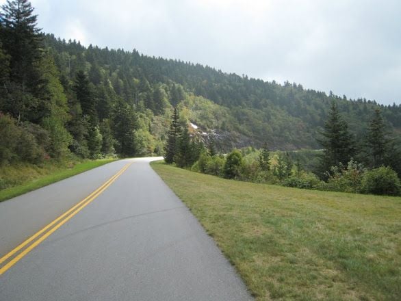
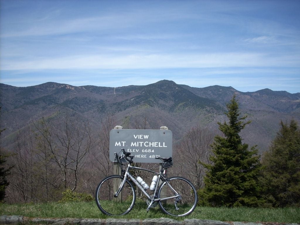
In all, the BRP although made for car travel is a bikers paradise. The road surface is excellent, the traffic is light and the views are really tremendous on both sides of the roads. Of course, the Queen stage is getting to the top of Mitchell. If it is a sunny day, you can see about 100 miles in all directions.
These shots were back in 2013. The shot at the overlook 4000+ feet was just north of Mitchell about 8 miles from the summit that you can see in the distance. The other shot is of my old steed (since retired) at the very summit. This was in the early spring too. Much nicer weather in the summer or early fall.
john
06-23-18, 02:11 PM
#12
Senior Member
Thread Starter
Join Date: Sep 2009
Posts: 1,971
Bikes: Habanero Titanium Team Nuevo
Mentioned: 4 Post(s)
Tagged: 0 Thread(s)
Quoted: 399 Post(s)
Liked 185 Times
in
121 Posts
Thanks to all for the response I have a much better picture of the place and what I need. I guess I am not terribly worried about the food and liquid situation as I have someone going along with me non rider. I did the google earth and followed the road and I see it is actually less of a highway as such than I thought. The pictures for your post have been great and sure would like to give it a try. Although I am a flatlander I am consider myself a fairly strong rider and can do some things to build up.
I did ride once in the Bozeman Mt area and of course some long climbs and such but was able to do fine. In a few places I was hurting but it was doable to keep going. I can see some of the off roads with very steep inclines would be rough for sure. Need to keep checking this out.
I did ride once in the Bozeman Mt area and of course some long climbs and such but was able to do fine. In a few places I was hurting but it was doable to keep going. I can see some of the off roads with very steep inclines would be rough for sure. Need to keep checking this out.
06-24-18, 05:37 PM
#13
Senior Member
Join Date: Mar 2018
Location: Indiana
Posts: 121
Bikes: Felt Z5, Look 675 Light, Specialized Diverge
Mentioned: 0 Post(s)
Tagged: 0 Thread(s)
Quoted: 48 Post(s)
Likes: 0
Liked 2 Times
in
1 Post
My favorite ride in the western part of the State, is the Greenville (SC) "Watershed" climb. Park at Hotel Domestique near Travelers Rest, SC and climb up to Saluda, NC. Some great scenery and a great climb. Stop at the Wildflour Bakery and get one of their legendary "sticky buns" then fly back down to the hotel. Save a bit of energy because the last mile to the hotel is uphill.
06-25-18, 09:40 AM
#14
Senior Member
Join Date: Dec 2010
Location: northern Deep South
Posts: 8,901
Bikes: Fuji Touring, Novara Randonee
Mentioned: 36 Post(s)
Tagged: 0 Thread(s)
Quoted: 2604 Post(s)
Liked 1,928 Times
in
1,210 Posts
Traffic generally isn't bad on the Parkway, with a few exceptions:
1. Holidays (July 4, Memorial Day, etc.): Try to get off the road by 10:00
2. Weekends: Usually OK until noon, maybe 10-11 around Asheville, Blowing Rock, and Roanoke
3. Peak leaf season (October): traffic picks up about noon
4. Rush hour near Roanoke and Asheville
If it's foggy, it's a good day to go shopping. Thickest fog I've ever seen was on the BRP.
07-02-18, 09:12 PM
#15
Let's do a Century

Join Date: Oct 2004
Location: North Carolina
Posts: 8,316
Bikes: Cervelo R3 Disc, Pinarello Prince/Campy SR; Cervelo R3/Sram Red; Trek 5900/Duraace, Lynskey GR260 Ultegra
Mentioned: 59 Post(s)
Tagged: 0 Thread(s)
Quoted: 651 Post(s)
Liked 879 Times
in
408 Posts
Just seeing this!!
I’ve ridden the BRP on numerous occasions and rode the full length plus Skyline Drive two years ago. First, there were parts of the BRP that were closed recently for one reason or another that you might want to check into. Sometimes the detours can be onerous even in a vehicle. Were you planning to camp or just use hotels?
I think someone mentioned climbing. While most of the climbs aren’t as long as you’ll find out West you can still expect 3-5 mile climbs at 6%.
Some places I’d recommend, Peaks of Otter Lodge in Va.......if you headed north from their you’d climb for several miles then you could descend for 13 miles (longest on the BRP). Of course you’d need to climb it to get back to the car. Or you could go South with more up and down in smaller bites. Peaks of Otter is one of my favorites though, good restaurant as well.
Floyd is just off the Parkway with decent lodging and food. I think you could do an out and back to Mabry Mill from near there.
There’s a nice stretch south of Blowing Rock that goes across the Viaduct over towards Grandfather Mtn. I think the viaduct just reopened. Hwy 221 would be a nice road to come back to BR on but it’s closed due to being washed out from the heavy rains. Blowing Rock is a neat mountain town.
Riding around Asheville is not fun. Folks use it for their local commuting so it gets busy.
The most scenic area to me is the area north of Waterrock which towards the southern end.
There are lots of overlooks along the Parkway where you could park and do out and backs.
Somewhere there is a link to the mile markers and elevations. What it yields is where the climbs and descents are all along the BRP. I found that to be pretty handy.
i can give you a lot more specifics if needed.
__________________
Ride your Ride!!
Ride your Ride!!
07-02-18, 09:22 PM
#16
Let's do a Century
Join Date: Oct 2004
Location: North Carolina
Posts: 8,316
Bikes: Cervelo R3 Disc, Pinarello Prince/Campy SR; Cervelo R3/Sram Red; Trek 5900/Duraace, Lynskey GR260 Ultegra
Mentioned: 59 Post(s)
Tagged: 0 Thread(s)
Quoted: 651 Post(s)
Liked 879 Times
in
408 Posts
Ok so maybe I want to do this and some questions. I am worried about traffic I ride chip seal in Illinois with not much traffic so a bunch of two-way traffic may give me a scare. Finally, I am not so worried about fitness the old marathoner can keep going but do not encounter any climbs in Illinois. I can get over them as I have in other places I have road but...���� I am running a compact with 28 ring in the rear as low gear. Seems I may need to go to a 30 or 32. What do you think.
The only area where I think you might be uncomfortable traffic wise is around Asheville. I�m okay with it but I�m used to riding in heavier traffic.
__________________
Ride your Ride!!
Ride your Ride!!
07-02-18, 09:30 PM
#17
Let's do a Century
Join Date: Oct 2004
Location: North Carolina
Posts: 8,316
Bikes: Cervelo R3 Disc, Pinarello Prince/Campy SR; Cervelo R3/Sram Red; Trek 5900/Duraace, Lynskey GR260 Ultegra
Mentioned: 59 Post(s)
Tagged: 0 Thread(s)
Quoted: 651 Post(s)
Liked 879 Times
in
408 Posts
My favorite ride in the western part of the State, is the Greenville (SC) "Watershed" climb. Park at Hotel Domestique near Travelers Rest, SC and climb up to Saluda, NC. Some great scenery and a great climb. Stop at the Wildflour Bakery and get one of their legendary "sticky buns" then fly back down to the hotel. Save a bit of energy because the last mile to the hotel is uphill.
__________________
Ride your Ride!!
Ride your Ride!!
07-03-18, 05:43 AM
#18
Senior Member
Regarding Asheville, riding north toward Craggy Garden's starting where Hwy 70/Folk Art Center is makes for a great ride (I think someone already mentioned this). If you want to avoid the long climbs, you could park at the Craggy Visitor Center and ride north toward Mt. Mitchell. I would avoid the commuter section of the Parkway around Asheville which is Hwy 70 (Tunnel Rd) south to Hwy 191. I have only cycled the section of the Parkway south of Asheville from Hwy 191 to Pisgah Inn when it was closed during the winter due to the numerous tunnels. You could start at Pisgah Inn in the high terrain and head south which would make for some nice riding albeit heavier in the traffic , there is nice campground across the Parkway from Pisgah Inn where you could van camp. Also the restaurant at Pisgah Inn is very good.
As jppe mentioned, you can make a loop out of the Parkway and Hwy 221 from Blowing Rock up to the Lynn Cove Viaduct at Grandfather Mountain. It is a great ride.
I will re-iterate that riding the Parkway during the week on non-Holiday weeks is the way to go. I relatively recently switched from a 34:25 to a 34:28 for the hills; since you will not be carrying gear, a 28 on the rear cassette should be fine given your level of fitness.
07-08-18, 03:56 PM
#19
Senior Member
Join Date: Jul 2008
Posts: 54
Mentioned: 0 Post(s)
Tagged: 0 Thread(s)
Quoted: 1 Post(s)
Likes: 0
Liked 0 Times
in
0 Posts
When you go, if you are up for a challenge, go to downtown Boone and try to climb Howard's Knob. It's only 2 miles, but has 20-25% climbing. I couldn't make it, but it was pretty neat to see what a 25% hill is. BTW, I was on a Mt. Bike.
07-08-18, 05:11 PM
#20
Let's do a Century
Join Date: Oct 2004
Location: North Carolina
Posts: 8,316
Bikes: Cervelo R3 Disc, Pinarello Prince/Campy SR; Cervelo R3/Sram Red; Trek 5900/Duraace, Lynskey GR260 Ultegra
Mentioned: 59 Post(s)
Tagged: 0 Thread(s)
Quoted: 651 Post(s)
Liked 879 Times
in
408 Posts
My riding buddies that live near Boone told me that Hwy 221 between Blowing Rock and Grandfather Mtn has reopened. I think you’d really enjoy the loop from Blowing Rock to Grandfather Mtn. Take Hwy 221 west from Blowing Rock to the BRP. Go north on the BRP back to where Shulls Mill Rd crosses the BRP and go back to Blowing Rock. This would take you over the viaduct.
__________________
Ride your Ride!!
Ride your Ride!!
07-09-18, 09:11 AM
#21
Senior Member
Join Date: Dec 2010
Location: northern Deep South
Posts: 8,901
Bikes: Fuji Touring, Novara Randonee
Mentioned: 36 Post(s)
Tagged: 0 Thread(s)
Quoted: 2604 Post(s)
Liked 1,928 Times
in
1,210 Posts
Don't know what the grade is, but you could also try climbing up past the town reservoir to Trout Lake. (I've only ever gone down that hill.) Quiet and scenic, if nothing else!

