


Cycling to top of Mount Mitchell
 07-18-20, 08:43 AM
#1
Senior Member
Thread Starter
Join Date: Apr 2014
Location: Connecticut
Posts: 523
Bikes: Trek Domane, Surly Disc Trucker
Mentioned: 3 Post(s)
Tagged: 0 Thread(s)
Quoted: 170 Post(s)
Liked 103 Times
in
68 Posts
Cycling to top of Mount Mitchell
Hi all ... I'm looking into cycling up Mount Mitchell in NC. I'm from the Northeast so not familiar with the area. when I do a Google Maps from either Marion or Asheville NC, it doesn't show that the last several miles (Rte 128) is rideable. When I have Maps set to 'cycling', the directions say to 'walk your bike' once it gets to the turn off to Rte 128. The car instructions don't show as being able to make the turn (unless I drag the route manually from the Blue Ridge Parkway). Anyone familiar with the climb and whether Rte 128 is open to bikes and/or cars these days? Thanks in advance.
 08-19-20, 08:35 AM
#2
Newbie
Join Date: Aug 2020
Location: Maryland
Posts: 4
Bikes: Merckx Mourenx 69
Mentioned: 0 Post(s)
Tagged: 0 Thread(s)
Quoted: 0 Post(s)
Likes: 0
Liked 1 Time
in
1 Post
I was up there a few weeks ago. All roads to the top of Mt Mitchell were open so you should be all good.
You could try calling the camp site though if you want to be absolutely sure.
You could try calling the camp site though if you want to be absolutely sure.
Likes For tbrewer02:
11-19-20, 03:29 PM
#3
Full Member
Join Date: Oct 2017
Location: South Carolina
Posts: 218
Bikes: Felt ZR3, Specialized Sectur
Mentioned: 1 Post(s)
Tagged: 0 Thread(s)
Quoted: 100 Post(s)
Likes: 0
Liked 52 Times
in
37 Posts
Don't know if this is still active or not. I've done Mitchell like 4 times.
The best ride and the one that the Assault on Mt Mitchell uses is from Marion, not Asheville. Start at Marion. You can park at the Lowe's on 70 and then ride up to the parkway on Rt 80. From Rt 80 to Mitchell it is 25 miles. To the Blue Ridge Parkway it is about 9 miles, then you have 16 to the top of Mitchell.
Be forewarned though, those 25 miles will see an elevation gain of almost 6,000 feet. The first 7 on 80 is nothing to write home about, but after that, it is all uphill except for one stretch on the BRP that is about 2 miles down hill.
The other issue no matter if you go from Marion or Asheville is the lack of water. There is no where to get any water, especially on the BRP. There is a small stand at the top of Mitchell but it is only open during the very late spring months into the summer. So, you will need water and food. The trip from Marion, depending on how good a rider you are, takes between 2-4 hours. I think the record is like 1.5 hours. Believe me, it is a lot of climbing.
If you need any more info, just ask.
Likes For rutan74:
07-31-21, 06:10 AM
#4
Senior Member
Join Date: Jan 2015
Posts: 151
Mentioned: 3 Post(s)
Tagged: 0 Thread(s)
Quoted: 35 Post(s)
Likes: 0
Liked 3 Times
in
3 Posts
I�ll be visiting my uncle in Asheville in a few weeks and am considering riding to Mt Mitchell. I was thinking of leaving directly from his house (about 35 miles to the top, brutal elevation of course) but would drive to Marion if there is a compelling reason.
07-31-21, 05:19 PM
#5
Full Member
Join Date: Oct 2017
Location: South Carolina
Posts: 218
Bikes: Felt ZR3, Specialized Sectur
Mentioned: 1 Post(s)
Tagged: 0 Thread(s)
Quoted: 100 Post(s)
Likes: 0
Liked 52 Times
in
37 Posts
could you please elaborate on what makes the ride from Marion better? E.g., difficulty, safety, views, etc?
I�ll be visiting my uncle in Asheville in a few weeks and am considering riding to Mt Mitchell. I was thinking of leaving directly from his house (about 35 miles to the top, brutal elevation of course) but would drive to Marion if there is a compelling reason.
I�ll be visiting my uncle in Asheville in a few weeks and am considering riding to Mt Mitchell. I was thinking of leaving directly from his house (about 35 miles to the top, brutal elevation of course) but would drive to Marion if there is a compelling reason.
Either way you choose, you will be on the Blue Ridge Parkway (BRP). The route from Marion (80 to the BRP) is 25 miles. The first five are not that bad as it is just some rolling road. At the church on rt 80 at about the 5-6 mile mark, you will enter hell. About 21 miles left and only 2 downhill miles that come in one long downhill on the BRP after a 6 mile plus climb.
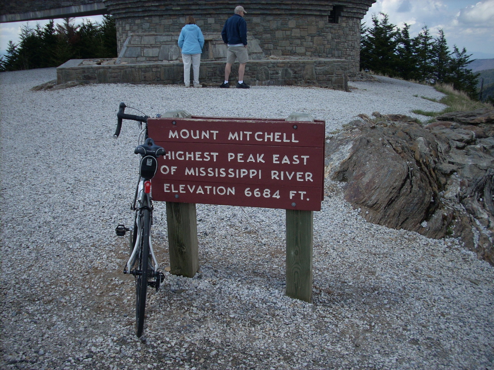
The route from Asheville will also be a lot of up. The good thing about the BRP is that there are a lot of scenic overlooks so you can take a break. The bad part no matter what direction, is the lack of water. The is a restaurant about a mile from the summit of Mitchell and then on the top, there is a small snack bar type of thing since there is a parking lot at the top where you can park for a 360 degree view. If the day is sunny, you will see easily 50+ miles. You will have to walk your bike to the absolute very top. It is just a concrete walking ramp but I carried mine up the ramp so I could get a photo of my bike and the sign at the very tip top.
The Marion route is probably the more cycled route as when I have ridden up there, there are always bikers on rt 80 up to the BRP. There used to be a photog near the top of 80. He is called Blind Kenny and he shoots photos of cars, motorcycles and bikes that are traveling on the road. Right where he used to sit, is called the Devil's Whip. Not sure if he still sits out there but he was usually there on weekends.
You can look up the Devil's Whip too online and you will see the route map from Marion to the BRP. It has like 180 turns. These are not switchbacks but just turns. The switchbacks don't happen until about a mile from the BRP. Once on the BRP from the Marion side, it is 16 miles to Mitchell. Only 2 miles of downhill on that 16 miles. You do get to go thru 2 tunnels on the way up that were hand dug. The BRP speed limit is also only 40mph and there are probably fewer cars coming from the north (Marion) than from the Asheville area. There are spots were the road opens up and it is very scenic. Just make sure you have enough food and water. I believe the KOM from Marion to Mitchell is just under 2 hours. Yes, 2 hours for a 25 mile ride. That is the fastest. Most manage it in 3-4 hours.
I have some pics if you want to see them. If you are in good shape it is a grind but worth it in the end. The steepest sections from the Marion side don't happen until you hit the access road that turn off the BRP and goes to the top of Mitchell. Not many pitches over 10%.
One of my excursions up there I met up with a group of drivers of model T's that were on their way to Atlanta for a car show. There is a ranger station just about 1.5 miles from the top with a parking lot and bathrooms and they were parked there taking a break. One driver came over and talked to me about riding a bike up there and said it was so tough that his car could not make the grade. So, it is not super steep but the climbs just go on forever. Have fun.
john
08-01-21, 08:10 PM
#6
Senior Member
Join Date: Jan 2015
Posts: 151
Mentioned: 3 Post(s)
Tagged: 0 Thread(s)
Quoted: 35 Post(s)
Likes: 0
Liked 3 Times
in
3 Posts
I have not ridden the route from Asheville to Mitchell. I have driven it, but not ridden it. I have done the route from Marion to Mitchell probably 6-7 times, all by bike.
Either way you choose, you will be on the Blue Ridge Parkway (BRP). The route from Marion (80 to the BRP) is 25 miles. The first five are not that bad as it is just some rolling road. At the church on rt 80 at about the 5-6 mile mark, you will enter hell. About 21 miles left and only 2 downhill miles that come in one long downhill on the BRP after a 6 mile plus climb.
The route from Asheville will also be a lot of up. The good thing about the BRP is that there are a lot of scenic overlooks so you can take a break. The bad part no matter what direction, is the lack of water. The is a restaurant about a mile from the summit of Mitchell and then on the top, there is a small snack bar type of thing since there is a parking lot at the top where you can park for a 360 degree view. If the day is sunny, you will see easily 50+ miles. You will have to walk your bike to the absolute very top. It is just a concrete walking ramp but I carried mine up the ramp so I could get a photo of my bike and the sign at the very tip top.
The Marion route is probably the more cycled route as when I have ridden up there, there are always bikers on rt 80 up to the BRP. There used to be a photog near the top of 80. He is called Blind Kenny and he shoots photos of cars, motorcycles and bikes that are traveling on the road. Right where he used to sit, is called the Devil's Whip. Not sure if he still sits out there but he was usually there on weekends.
You can look up the Devil's Whip too online and you will see the route map from Marion to the BRP. It has like 180 turns. These are not switchbacks but just turns. The switchbacks don't happen until about a mile from the BRP. Once on the BRP from the Marion side, it is 16 miles to Mitchell. Only 2 miles of downhill on that 16 miles. You do get to go thru 2 tunnels on the way up that were hand dug. The BRP speed limit is also only 40mph and there are probably fewer cars coming from the north (Marion) than from the Asheville area. There are spots were the road opens up and it is very scenic. Just make sure you have enough food and water. I believe the KOM from Marion to Mitchell is just under 2 hours. Yes, 2 hours for a 25 mile ride. That is the fastest. Most manage it in 3-4 hours.
I have some pics if you want to see them. If you are in good shape it is a grind but worth it in the end. The steepest sections from the Marion side don't happen until you hit the access road that turn off the BRP and goes to the top of Mitchell. Not many pitches over 10%.
One of my excursions up there I met up with a group of drivers of model T's that were on their way to Atlanta for a car show. There is a ranger station just about 1.5 miles from the top with a parking lot and bathrooms and they were parked there taking a break. One driver came over and talked to me about riding a bike up there and said it was so tough that his car could not make the grade. So, it is not super steep but the climbs just go on forever. Have fun.
john
08-02-21, 09:22 AM
#7
Full Member
Join Date: Oct 2017
Location: South Carolina
Posts: 218
Bikes: Felt ZR3, Specialized Sectur
Mentioned: 1 Post(s)
Tagged: 0 Thread(s)
Quoted: 100 Post(s)
Likes: 0
Liked 52 Times
in
37 Posts
Just remember, what goes up, must go down so unless you have a driver, you will have to cycle back. The route from Asheville is 30+ miles and then the return trip. Marion is 25 and the return trip only has a 2 mile climb and that is basically it. You are downhill from there. I can tell you the trip down is a real blast if you like descending.
If you decide on the Marion side, check the map for 70 and then 80. About a mile or so before the turn onto 80 is a Lowes. I usually park my car there and then use the 1-2 miles to Route 80 as a warm up so to speak. If you have a driver then no need.
This is what you are up against on the way to the BRP on 80. In this shot, you are almost to the BRP.

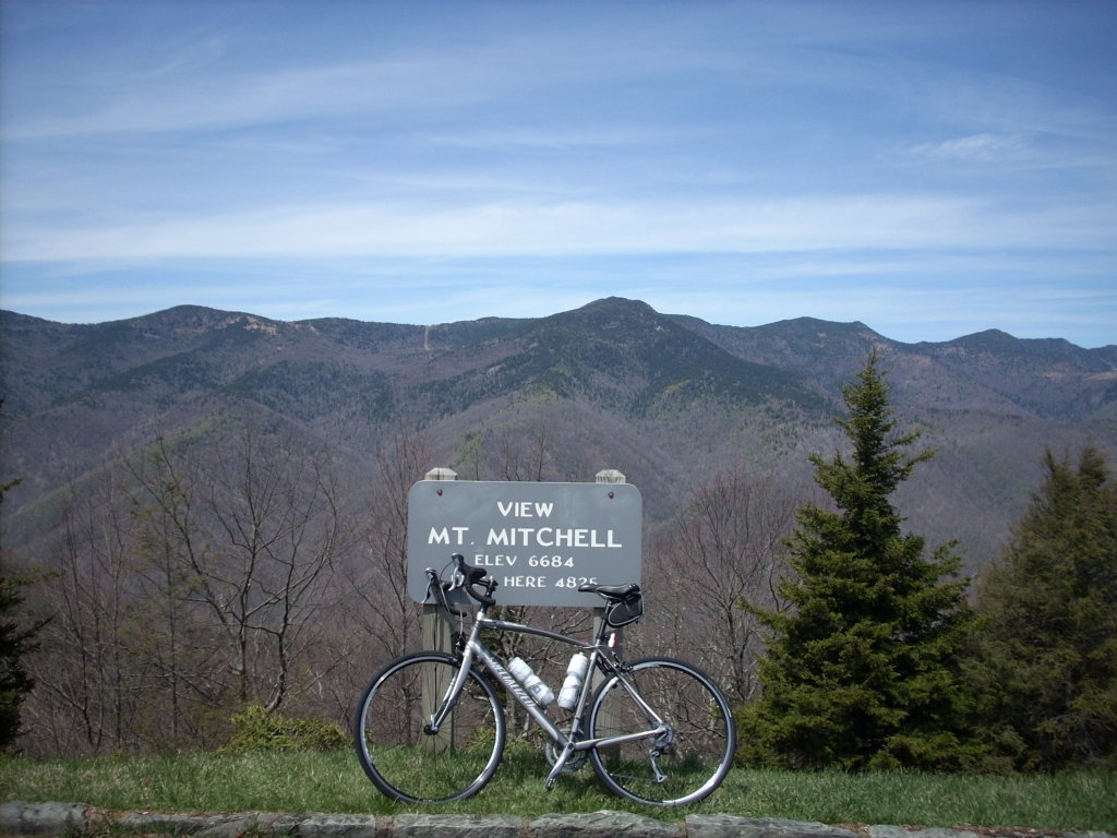
One of the overlooks on the BRP. Mitchell is off in the distance. From this point, 8 miles to go. 2000 ft of climbing left in 6 miles. Right after this overlook, there is a 2 mile downhill and then it is all up to the top. So, 2000 ft in 6 miles.
 03-17-22, 07:22 PM
#8
Newbie
Join Date: Mar 2022
Location: Mars Hill, NC
Posts: 19
Bikes: Litespeed Tuscany
Mentioned: 0 Post(s)
Tagged: 0 Thread(s)
Quoted: 2 Post(s)
Likes: 0
Liked 11 Times
in
8 Posts
This is a new reply to an old post (I'm a new member). So it might be too late.
I live 17 miles from Mount Mitchell. The big question is, how many miles do you want to do on your ascent? The BRP is fabulous - it's a bike road on which cars are reluctantly tolerated. If you approach from rte 80, that's a nice ride, but beware of Burnsville, because rte 19 can be hairy. I recommend driving to the Folk Art Center on the BRP and riding from there. It's about 63 miles R/T to the summit. If that's too short, you can always go longer the next day. But you'll only be riding the BRP and the Mount Mitchell access road. All excellent roadways.
I live 17 miles from Mount Mitchell. The big question is, how many miles do you want to do on your ascent? The BRP is fabulous - it's a bike road on which cars are reluctantly tolerated. If you approach from rte 80, that's a nice ride, but beware of Burnsville, because rte 19 can be hairy. I recommend driving to the Folk Art Center on the BRP and riding from there. It's about 63 miles R/T to the summit. If that's too short, you can always go longer the next day. But you'll only be riding the BRP and the Mount Mitchell access road. All excellent roadways.
Likes For DoggettDude:
04-19-22, 05:43 AM
#9

Should Be More Popular

Join Date: Dec 2007
Location: Malvern, PA (20 miles West of Philly)
Posts: 43,038
Bikes: 1986 Alpine (steel road bike), 2009 Ti Habenero, 2013 Specialized Roubaix
Mentioned: 560 Post(s)
Tagged: 2 Thread(s)
Quoted: 22583 Post(s)
Liked 8,923 Times
in
4,156 Posts
Bumping this thread.....
I am an avid road cyclist, I love to climb hills, and will be in Asheville in 2 weeks (early May 2022). I certainly want to ride up to the top of Mt Mitchell.
Here is a suggested route I found on the internet. I am guessing it's probably a fine way to go, but I am open to other suggestions. Comments??
https://ridewithgps.com/routes/37345059
Last edited by datlas; 04-19-22 at 05:48 AM.
Likes For datlas:
04-19-22, 09:32 AM
#10
Newbie
Join Date: Mar 2022
Location: Mars Hill, NC
Posts: 19
Bikes: Litespeed Tuscany
Mentioned: 0 Post(s)
Tagged: 0 Thread(s)
Quoted: 2 Post(s)
Likes: 0
Liked 11 Times
in
8 Posts
Yes, that is the route that I recommended above. Only they were kind enough to RWGPS it for you. I would stick with that, because the roads are good and you pretty much can't get lost: there is a grand total of one turn each way. HOWEVER,
1) Check with the national park service first, because there might be a weather-related road closure. https://www.nps.gov/blri/index.htm
2) The final 4.25 miles are in a NC state park, not the national BRP. https://www.ncparks.gov/mount-mitchell-state-park/home
After you get here, you will find that you can do hundreds of miles on fabulous hilly roads and go nowhere near the BRP. Mount Mitchell is the draw, but the whole region is cycling paradise. I might still be too new to the forum to get a PM, but you can give it a try, and I'll show you some roads if you like.
Likes For DoggettDude:
04-19-22, 10:40 AM
#11
Should Be More Popular
Join Date: Dec 2007
Location: Malvern, PA (20 miles West of Philly)
Posts: 43,038
Bikes: 1986 Alpine (steel road bike), 2009 Ti Habenero, 2013 Specialized Roubaix
Mentioned: 560 Post(s)
Tagged: 2 Thread(s)
Quoted: 22583 Post(s)
Liked 8,923 Times
in
4,156 Posts
Yes, that is the route that I recommended above. Only they were kind enough to RWGPS it for you. I would stick with that, because the roads are good and you pretty much can't get lost: there is a grand total of one turn each way. HOWEVER,
1) Check with the national park service first, because there might be a weather-related road closure. https://www.nps.gov/blri/index.htm
2) The final 4.25 miles are in a NC state park, not the national BRP. https://www.ncparks.gov/mount-mitchell-state-park/home
After you get here, you will find that you can do hundreds of miles on fabulous hilly roads and go nowhere near the BRP. Mount Mitchell is the draw, but the whole region is cycling paradise. I might still be too new to the forum to get a PM, but you can give it a try, and I'll show you some roads if you like.
1) Check with the national park service first, because there might be a weather-related road closure. https://www.nps.gov/blri/index.htm
2) The final 4.25 miles are in a NC state park, not the national BRP. https://www.ncparks.gov/mount-mitchell-state-park/home
After you get here, you will find that you can do hundreds of miles on fabulous hilly roads and go nowhere near the BRP. Mount Mitchell is the draw, but the whole region is cycling paradise. I might still be too new to the forum to get a PM, but you can give it a try, and I'll show you some roads if you like.
We are spending a whole week in Asheville so I do hope/plan to do a few rides. I might even be able to get my wife to drop me off at location SE of Mt Mitchell so I can ride up from the other side.
04-19-22, 11:49 AM
#12
Newbie
Join Date: Mar 2022
Location: Mars Hill, NC
Posts: 19
Bikes: Litespeed Tuscany
Mentioned: 0 Post(s)
Tagged: 0 Thread(s)
Quoted: 2 Post(s)
Likes: 0
Liked 11 Times
in
8 Posts
Yes, Elk Mountain Scenic Hwy is another classic. Depending on where you are staying, you might want to park at the Fresh Market on Merrimon Avenue (pick up some munchies later!), cross at the light (ride around the back to get to the stoplight), and ride Beaverdam to Elk Mountain. Once you've crossed Merrimon, the traffic should be good. Elk Mountain is a sweet climb, and from the top, you can sail back down, access the BRP north or south, or descend Ox Creek towards Weaverville.
Asheville's dirty little secret is that while America comes to Asheville to ride, Asheville comes to Madison County to ride. Madison County is 15 miles north, and much quieter. Check out the Hot Doggett routes: https://hotdoggett100.org if you are able to go north of Asheville. And come back in July for Hot Doggett -- we'd love to have you join the fun.
You probably know this, but gear your bike for the hills and check your brakes!
Likes For DoggettDude:
04-22-22, 08:24 AM
#13
Senior Member

Join Date: Sep 2017
Location: Upstate SC
Posts: 1,698
Mentioned: 3 Post(s)
Tagged: 0 Thread(s)
Quoted: 817 Post(s)
Liked 1,651 Times
in
778 Posts
Bumping this thread.....
I am an avid road cyclist, I love to climb hills, and will be in Asheville in 2 weeks (early May 2022). I certainly want to ride up to the top of Mt Mitchell.
Here is a suggested route I found on the internet. I am guessing it's probably a fine way to go, but I am open to other suggestions. Comments??
https://ridewithgps.com/routes/37345059
I am an avid road cyclist, I love to climb hills, and will be in Asheville in 2 weeks (early May 2022). I certainly want to ride up to the top of Mt Mitchell.
Here is a suggested route I found on the internet. I am guessing it's probably a fine way to go, but I am open to other suggestions. Comments??
https://ridewithgps.com/routes/37345059
The Assaults |
04-29-22, 08:48 AM
#14
Should Be More Popular
Join Date: Dec 2007
Location: Malvern, PA (20 miles West of Philly)
Posts: 43,038
Bikes: 1986 Alpine (steel road bike), 2009 Ti Habenero, 2013 Specialized Roubaix
Mentioned: 560 Post(s)
Tagged: 2 Thread(s)
Quoted: 22583 Post(s)
Liked 8,923 Times
in
4,156 Posts
So I am coming this weekend and will be there all next week. The weather looks like some days may have spotty showers, but I do hope to ride.
Next question, assuming I want to do the out/back from Asheville to Mt Mitchell and I could either do it on a Sunday or a weekday, does it matter (specifically concerned about traffic volume etc??
I am inclined to do it on Sunday, but willing to change if traffic is an issue.
Reminder, this is the route I intend to take: https://ridewithgps.com/routes/37345059
05-04-22, 04:36 AM
#15
Should Be More Popular
Join Date: Dec 2007
Location: Malvern, PA (20 miles West of Philly)
Posts: 43,038
Bikes: 1986 Alpine (steel road bike), 2009 Ti Habenero, 2013 Specialized Roubaix
Mentioned: 560 Post(s)
Tagged: 2 Thread(s)
Quoted: 22583 Post(s)
Liked 8,923 Times
in
4,156 Posts
Update, I did the ride this week. It was really good. One point to anyone who sees this thread, at least in early May, water is SCARCE on this ride. None of the water fountains are on yet. I got water from the faucet at the Ranger station restroom on Mt Mitchell. Best I can tell, that’s the only water on the entire ride. I am hopeful they turn on the water fountains once the “season” starts.
Likes For datlas:
05-04-22, 05:20 AM
#16

don't try this at home.

Join Date: Jan 2006
Location: N. KY
Posts: 5,936
Mentioned: 10 Post(s)
Tagged: 0 Thread(s)
Quoted: 973 Post(s)
Liked 511 Times
in
351 Posts
Shorter Mt Mitchell: Just the best parts!
Singecat Ridge overlook to Mt Mitchell and back.
a 1500 foot climb right from the car! At the top, cruise through Mt Mitchell View overlook, with the summit way across the valley. A great finish to the ride, too.
The Assault on Mt Mitchell climbs up steep NC-80, with it's switchbacks, then continues on the parkway. This overlook is a couple of miles from the intersection.
From Asheville, drive to Old Fort NC, US-70, then NC-80.
I don't usually ride the BRP out of Asheville, either up toward Mt Mitchell or up toward the Pisgah Inn. It has more traffic and the views are "nice", but don't really compare to the high elevations on the Parkway.
Here's my favorite ride on the Parkway near Asheville. It follows the ridge lines most of the way. Amazing views on the whole ride, with a mix of climbing and descending.
I usually do a shorter version of this: Cherry Cove to Richland Balsam crest, continue to DoubleTop overlook, then return. No water along the way, except for the Pisgah Inn.
Cherry Cove-Richland Balsam extended
A variation is to head to the Pisgah Inn for carryout lunch on the back deck, with expansive views across the valley. Good for water, food, and restroom at the halfway point.
Doubletop to Pisgah Inn
or from the Pinnacle Ridge tunnel overlook.
Bring a headlight for the tunnels! Those spikes on the elevation chart are the tunnels -- rwgps thinks the road climbs over the ridge instead of tunneling through.
Last edited by rm -rf; 05-04-22 at 05:28 AM.
05-05-22, 02:37 PM
#17
Full Member
Join Date: Oct 2017
Location: South Carolina
Posts: 218
Bikes: Felt ZR3, Specialized Sectur
Mentioned: 1 Post(s)
Tagged: 0 Thread(s)
Quoted: 100 Post(s)
Likes: 0
Liked 52 Times
in
37 Posts
You really want to challenge yourself? The 2022 event is sold out, but there's always next year!
The Assaults |
The Assaults |
john
Likes For rutan74:
05-05-22, 02:42 PM
#18
Full Member
Join Date: Oct 2017
Location: South Carolina
Posts: 218
Bikes: Felt ZR3, Specialized Sectur
Mentioned: 1 Post(s)
Tagged: 0 Thread(s)
Quoted: 100 Post(s)
Likes: 0
Liked 52 Times
in
37 Posts
Update, I did the ride this week. It was really good. One point to anyone who sees this thread, at least in early May, water is SCARCE on this ride. None of the water fountains are on yet. I got water from the faucet at the Ranger station restroom on Mt Mitchell. Best I can tell, that�s the only water on the entire ride. I am hopeful they turn on the water fountains once the �season� starts.
Still, great ride. Now, how was the descent from Mitchell? Hold on to your helmet. That is/was some fun.
If you venture a little south of Asheville, there is some great riding around Lake Lure and Chimney Rock. If open, the Chimney Rock climb is brutal too. Right in the little village of Bat Cave. There are some really crazy climbs around there coming off the BRP or going up to the BRP. I would really like to bike inside the Biltmore. Those roads seem like they would be nice to explore but I am not sure they allow bikes.
john
05-05-22, 03:57 PM
#19
Should Be More Popular
Join Date: Dec 2007
Location: Malvern, PA (20 miles West of Philly)
Posts: 43,038
Bikes: 1986 Alpine (steel road bike), 2009 Ti Habenero, 2013 Specialized Roubaix
Mentioned: 560 Post(s)
Tagged: 2 Thread(s)
Quoted: 22583 Post(s)
Liked 8,923 Times
in
4,156 Posts
Great! Glad you made it. Even in the summer, coming from the Marion side, there is no water with the exception of the Ranger Station or when you get to the top, the small snack bar which is usually not open in early May.
Still, great ride. Now, how was the descent from Mitchell? Hold on to your helmet. That is/was some fun.
If you venture a little south of Asheville, there is some great riding around Lake Lure and Chimney Rock. If open, the Chimney Rock climb is brutal too. Right in the little village of Bat Cave. There are some really crazy climbs around there coming off the BRP or going up to the BRP. I would really like to bike inside the Biltmore. Those roads seem like they would be nice to explore but I am not sure they allow bikes.
john
Today I took Town Mountain road to the BRP and went South to Mt Pisgah Campgrounds. Same water issue, only water options were at the visitor center and then at Mt Pisgah. Sadly, no option to summit Mt Pisgah from the BRP.
06-09-22, 07:56 AM
#20
Senior Member
Thread Starter
Join Date: Apr 2014
Location: Connecticut
Posts: 523
Bikes: Trek Domane, Surly Disc Trucker
Mentioned: 3 Post(s)
Tagged: 0 Thread(s)
Quoted: 170 Post(s)
Liked 103 Times
in
68 Posts
Great reading all the details and ride reports. The link I saw about a route to Mount Mitchell (same link as posted earlier in this thread and starting from the Folk Art Center in/near Asheville) said there was a stop at the Craggy Gardens Visitor Center did have restrooms and you could get a water refill. Was the "no water" comment referring just to early/late season?
06-09-22, 06:12 PM
#21
Should Be More Popular
Join Date: Dec 2007
Location: Malvern, PA (20 miles West of Philly)
Posts: 43,038
Bikes: 1986 Alpine (steel road bike), 2009 Ti Habenero, 2013 Specialized Roubaix
Mentioned: 560 Post(s)
Tagged: 2 Thread(s)
Quoted: 22583 Post(s)
Liked 8,923 Times
in
4,156 Posts
Great reading all the details and ride reports. The link I saw about a route to Mount Mitchell (same link as posted earlier in this thread and starting from the Folk Art Center in/near Asheville) said there was a stop at the Craggy Gardens Visitor Center did have restrooms and you could get a water refill. Was the "no water" comment referring just to early/late season?
Likes For datlas:
06-16-22, 07:29 AM
#22
Full Member
Join Date: Jul 2019
Location: Greer, SC
Posts: 344
Bikes: GR300, Grail, Live Wire, 5010
Mentioned: 1 Post(s)
Tagged: 0 Thread(s)
Quoted: 189 Post(s)
Liked 241 Times
in
121 Posts
Great reading all the details and ride reports. The link I saw about a route to Mount Mitchell (same link as posted earlier in this thread and starting from the Folk Art Center in/near Asheville) said there was a stop at the Craggy Gardens Visitor Center did have restrooms and you could get a water refill. Was the "no water" comment referring just to early/late season?

Likes For sarhog:
06-16-22, 07:45 AM
#23
Senior Member
Thread Starter
Join Date: Apr 2014
Location: Connecticut
Posts: 523
Bikes: Trek Domane, Surly Disc Trucker
Mentioned: 3 Post(s)
Tagged: 0 Thread(s)
Quoted: 170 Post(s)
Liked 103 Times
in
68 Posts
I've got a trip planned for first week of September (I was considering a trip in 2020 when I first posted this in early covid but didn't end up going) We're staying at a place about twenty miles from the summit (near Burnsville) so the most convenient route would be from my doorstep, Route 80 south for around 4.5 miles, onto the Blue Ridge Parkway, then up 128. Looks like no water on the way up going that route but it's 20 miles and around 4,400 feet vertical so I should be able to carry enough food and water (and maybe recruit my wife to drive support).
I'll see when I'm there about doing another route from the Folk Art Center through Craggy Gardens and up to the summit. Doing that route, I'd definitely ask my wife for SAG support and probably hop in the car for the ride back as going up will definitely test my limits
Won't lie, at 69 years old when I go up, I'm a bit nervous but I'll feel worse if I don't even try than if I try and don't make it all the way.
06-16-22, 11:49 AM
#24
Newbie
Join Date: Mar 2022
Location: Mars Hill, NC
Posts: 19
Bikes: Litespeed Tuscany
Mentioned: 0 Post(s)
Tagged: 0 Thread(s)
Quoted: 2 Post(s)
Likes: 0
Liked 11 Times
in
8 Posts
There is a convenience store at the summit, by the start of the path to the observation deck. It's been open every time I've been there. They sell soda and snacks and (I think) bottled water.
Likes For DoggettDude: