


How Safe is PCH?
 07-15-12, 04:15 PM
#1
Member
Thread Starter
Join Date: Jan 2012
Posts: 43
Mentioned: 0 Post(s)
Tagged: 0 Thread(s)
Quoted: 0 Post(s)
Likes: 0
Liked 0 Times
in
0 Posts
How Safe is PCH?
I've never ridden on PCH before, but I was considering doing a ride this Saturday that would have me on there for a while. How safe (or unsafe) is it to ride on PCH by myself in the morning between Santa Monica and Western Malibu?
 07-15-12, 08:11 PM
#2
Senior Member
Join Date: Aug 2009
Posts: 239
Mentioned: 0 Post(s)
Tagged: 0 Thread(s)
Quoted: 0 Post(s)
Likes: 0
Liked 0 Times
in
0 Posts
I ride in the Santa Monica Mountains by preference, but there are times when I'm in the mood for a road ride. I'll head north on PCH early in the morning on weekends and holidays, and it's a good ride. Most of the way the shoulder is wide enough for bikes to be completely clear of the traffic lane, northbound. There's a short stretch where some construction has the shoulder closed, roughly 500 feet.
Southbound is different. There are more cars parked beside the road, and more driveways. Still, there's usually room to stay out of the traffic lane. Around Sunset Boulevard you'll need to be careful of surfers parking and unloading their gear. You can get through the guard rail at the crosswalk marked by flashing beacons, and ride in the parking lot to where the bike path begins. I highly recommend not riding PCH south of Temescal Canyon because it's three lanes with no room for bikes, and the traffic is fast. The bike path has its own hazards on weekends, but I think it's preferable. If you want to get off that, there's a tunnel under PCH at Entrada, and you can ride up the hill into Santa Monica and use one of the side streets; I often use 4th to go south.
Southbound is different. There are more cars parked beside the road, and more driveways. Still, there's usually room to stay out of the traffic lane. Around Sunset Boulevard you'll need to be careful of surfers parking and unloading their gear. You can get through the guard rail at the crosswalk marked by flashing beacons, and ride in the parking lot to where the bike path begins. I highly recommend not riding PCH south of Temescal Canyon because it's three lanes with no room for bikes, and the traffic is fast. The bike path has its own hazards on weekends, but I think it's preferable. If you want to get off that, there's a tunnel under PCH at Entrada, and you can ride up the hill into Santa Monica and use one of the side streets; I often use 4th to go south.
07-15-12, 08:24 PM
#3
Senior Member
Join Date: Dec 2011
Location: MANHATTAN BEACH, CA
Posts: 209
Bikes: 2013 BMC GRAN FONDO GF01, 2010 SPECIALIZED ROUBAIX, 2004 TREK FX7000, 2013 SPECIALIZED ALLEZ
Mentioned: 1 Post(s)
Tagged: 0 Thread(s)
Quoted: 1 Post(s)
Likes: 0
Liked 0 Times
in
0 Posts
I was always scared of PCH until a biking buddy lead the way. Now it is one of my favorite rides, and is the gateway to all of the challeninging climbs that run from the coast.
However, I won't ride on PCH until after Temescal Canyon, going towards Malibu. No shoulder, cars go way too fast, and there is no escape route. I ride the bike path and then get on PCH at Temescal. There is enough of a shoulder after Temescal to give some cushion, but there are still some sketchy spots. After Pepperdine PCH gets less busy with wider shoulders.
Coming back, the cars parked outside of the beachside houses, or at the beach, can create some problems, either with opening doors or blocking the lane.
Groups of riders will congregate at Temescal waiting for the light to cross PCH and head north/west. Consider latching on to a group, or find a club ride headed in that direction, for the first go.
But, in my opinion, PCH is not much different than riding on any other busy road. Pay attention to what you are doing,
be aware of what is going on around you, and enjoy the view.
07-16-12, 04:47 PM
#5
Senior Member
Join Date: Jul 2011
Location: Los Angeles, CA
Posts: 600
Bikes: All-City Space Horse!
Mentioned: 0 Post(s)
Tagged: 0 Thread(s)
Quoted: 0 Post(s)
Likes: 0
Liked 0 Times
in
0 Posts
A young women died on PCH last week while cycling near Entrada Drive. Just like any road, it can be safe, but there are fatalities on it.
https://losangeles.cbslocal.com/2012/...bike-rider-29/
https://losangeles.cbslocal.com/2012/...bike-rider-29/
Last edited by weshigh; 07-16-12 at 05:23 PM.
07-16-12, 05:11 PM
#6
Senior Member

Join Date: Oct 2004
Posts: 4,224
Mentioned: 0 Post(s)
Tagged: 0 Thread(s)
Quoted: 1 Post(s)
Likes: 0
Liked 6 Times
in
6 Posts
I just went to the Getty Villa a few weeks back and noticed that the cycling lane is kinda not there between Santa Monica and the Villa. I did see a few cyclists, but I'll advise that you use the beach trail instead of the PCH in that area.
07-16-12, 08:48 PM
#7
Senior Member
Join Date: Dec 2009
Location: SoCal
Posts: 52
Bikes: Caad 9
Mentioned: 0 Post(s)
Tagged: 0 Thread(s)
Quoted: 3 Post(s)
Likes: 0
Liked 0 Times
in
0 Posts
A young women died on PCH last week while cycling near Entrada Drive. Just like any road, it can be safe, but there are fatalities on it.
https://losangeles.cbslocal.com/2012/...bike-rider-29/
https://losangeles.cbslocal.com/2012/...bike-rider-29/
07-27-12, 02:57 PM
#8
Flat Ire
PCH seems to take one cyclist per year, on the average.
An alternate to the beach path for south of Temescal is to take 7th St in SM. Its north end winds around to PCH via W. Channel Rd.
An alternate to the beach path for south of Temescal is to take 7th St in SM. Its north end winds around to PCH via W. Channel Rd.
07-27-12, 03:01 PM
#9


Senior Member
Join Date: Jul 2010
Posts: 5,793
Mentioned: 6 Post(s)
Tagged: 0 Thread(s)
Quoted: 1021 Post(s)
Liked 464 Times
in
293 Posts
But, IF I am going to get killed while riding my bike, I want it to be on PCH, while near my beloved Pacific Ocean.
07-27-12, 05:42 PM
#10
Junior Member
Join Date: May 2011
Location: North Hollywood, CA
Posts: 19
Bikes: CAAD10
Mentioned: 0 Post(s)
Tagged: 0 Thread(s)
Quoted: 0 Post(s)
Likes: 0
Liked 0 Times
in
0 Posts
A group of about 12-15 riders riding from Pepperdine to Oxnard then back. About 75 miles round trip. Feel free to join us if you like. We are planning to meet at Malibu Bluffs Park around 7am then roll 7:30am sharp.
07-27-12, 08:40 PM
#12
Senior Member
What an awesome ride! If I hadn't planned on GMR/GRR tomorrow... Does your group do this often?
07-28-12, 04:23 AM
#13
Senior Member
Join Date: Feb 2012
Posts: 331
Mentioned: 0 Post(s)
Tagged: 0 Thread(s)
Quoted: 3 Post(s)
Likes: 0
Liked 1 Time
in
1 Post
I ride PCH, but in the OC area. I pass by this ghost bike 3 times a week.
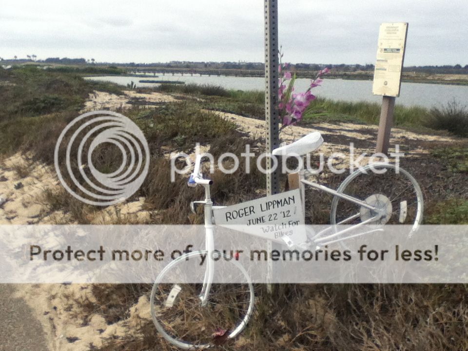
Be safe. Unfortunately that wasn't enough for him. The driver was drunk at 11am.
Be safe. Unfortunately that wasn't enough for him. The driver was drunk at 11am.
07-30-12, 10:47 AM
#15
Junior Member
Join Date: May 2011
Location: North Hollywood, CA
Posts: 19
Bikes: CAAD10
Mentioned: 0 Post(s)
Tagged: 0 Thread(s)
Quoted: 0 Post(s)
Likes: 0
Liked 0 Times
in
0 Posts
Last edited by HollywoodG; 07-30-12 at 01:54 PM.
07-30-12, 01:39 PM
#16
Senior Member
The problem with PCH is that it ISN'T like any other busy road, in that it's the connector for every beach in Socal and attracts people/drivers who don't live in the area(s).
3 cyclists killed on PCH in the last 6 weeks. Summer is not a good time for cyclists on this road...
3 cyclists killed on PCH in the last 6 weeks. Summer is not a good time for cyclists on this road...
08-06-12, 06:47 AM
#17
Senior Member
Join Date: Jul 2010
Posts: 5,793
Mentioned: 6 Post(s)
Tagged: 0 Thread(s)
Quoted: 1021 Post(s)
Liked 464 Times
in
293 Posts
It was a nice ride. Weather was much better for cycling than in San Fernando Valley where most of us are from. We left Malibu Bluff Park closer to 8am. The sun was already peeking through the marine clouds. We made a quick stop at Neptune's Net to regroup (1 rider got a flat tire 10-12 miles into the ride). There were a few road construction along the way, but nothing made our ride un-safe. After riding for another 11-12 miles, we made another quick stop at Point Mugu Naval Base to regroup and took the opportunity to take some photos with old military planes on display along the road (see photo below). We rode for another 10 miles to Hueneme Beach Park where we had lunch. After lunch, we decided to keep going north to Channel Islands for another 5 miles. After a quick group photo, we headed back to Malibu. Total miles = 75, average speed = 15, hours = 5.

Please announce it next time you do it.
And I am pretty sure that I passed your group going the opposite way.


