


Denver to Glenwood Springs?
 08-01-19, 07:01 PM
#1
Every day a winding road
Thread Starter

Denver to Glenwood Springs?
A post in the recent bike path threads got me thinking. I did not realize how far some of those bike paths extend. And with Mt. Hood under my belt, mayabe it is time for another challenge? OK Mt Hood was a struggle for me but it was mainly the mind.
My thought was to fly into Denver and head for Glenwood Springs via Breckenridge. I would not be camping.
Before I go off and do detailed analysis I was hoping to get some answers to a few questions,
First and foremost, how bad are the climbs heading west? And what about the wind? Is it typically stronger in one direction over the other?
The route seems to really hug the interstate. Is it far enough away that I won't have trucks buzzing in my ear the whole route? What about traffic on the frontage roads.
Are there enough towns with hotels every 40 or 50 miles? I can do longer if I don't have much of a climb. I did quick check and it looks like there are plenty of places between Denver and Breckenridge but I did not get to the rest of the route yet.
 08-02-19, 12:09 AM
#2
Banned.
You're coming from Pittsburgh directly and heading straight up by bike? Have you ever climbed altitude like that before? I know you mentioned Mt. Hood, but I don't have a full understanding of the inclines and altitude there, or really even what you did there exactly, but if you never have been here before, it is no walk in the park. Coming in from sea level, sitting at 6000 feet, and then climbing up and down steep climbs like that, not to mention pretty much ascending most of the way from Denver to those places you mentioned, is a lot for even seasoned riders I would think.
You mentioned "mental challenge." What does that mean exactly?
Most of the time for me that means pushing my body through something it's not use to and saying, "you can do it kind of stuff..." You better be past that point if you are seriously going to climb up to those places at altitude. If you're not use to climbing hills in general, especially Rocky Mountain hills at a mile up, you might want to really think about this.
Even if you are in shape, you're not guaranteed that you will acclimate to the altitude right away either. Just getting up out of Golden area into the hills by bike is going to be a hell of a start for your endurance, lungs, and physical agility if you are not in tip top shape. I can't honestly answer you about routes up into the mountains past the foothills and what that entails exactly. I would be curious to find out with you as I don't ride that way and probably will be soon though.
Have back up plans in the event you don't acclimate right away. And hydrate constantly. Plan your hotels ahead of time so you don't run into surprises on that route. I honestly think your biggest problem is getting through Eisenhower tunnel but I think there are other ways to deal with that. I am sure some of the more season veterans will explain shortly on how to do it. I am all ears too. Need to learn that part myself. I would like to head up that way in the next few weeks and get more back country for the remainder of the summer. Also be prepared for drastic changes in weather. You can have a thunderstorm role up on you anywhere. There was a major road in Denver in the last two weeks called Colfax, that was literally under water up to the middle of the cars because of a flash flood from rains that came in to quick. Also temp's drop severely in evenings and night the higher you go and even on a bike you need to be prepared. You can go from your bike shorts to multiple layers in just a few hours, or you can catch it just right and get beautiful weather the entire way. That's the awesome thing about here! It's spectacular until, Pow! Then it's spectacular again!
Going to look at the map now on that but I won't know enough to help you there even looking at it. It's different from biking to driving out here. Almost like two different worlds in many ways! Truly one of the best bike places to ride in the world though!
Last edited by Bike Jedi; 08-02-19 at 12:12 AM.
08-02-19, 04:04 AM
#3
Senior Member
Join Date: Jan 2010
Posts: 39,483
Mentioned: 211 Post(s)
Tagged: 1 Thread(s)
Quoted: 18517 Post(s)
Liked 15,846 Times
in
7,443 Posts
What is "the" route?
If you map it on RWGP you can see the grades.
If you map it on RWGP you can see the grades.
08-02-19, 08:47 AM
#4
Every day a winding road
Thread Starter
Here is the basic route.
https://www.google.com/maps/dir/Denv...76!3e1!5m1!1e3
Bike Jedi makes a good point. Looks like the route gets above 11K feet. Never been that high. I reached 5K on Mt Hood but the Rockies are over twice that.
https://www.google.com/maps/dir/Denv...76!3e1!5m1!1e3
Bike Jedi makes a good point. Looks like the route gets above 11K feet. Never been that high. I reached 5K on Mt Hood but the Rockies are over twice that.
08-02-19, 09:34 AM
#5
Banned.
That route takes you over Loveland Pass 12,000 feet and Vail Pass at 10,600!
We have an annual ride that does this. Usually have many casualties along the way.
https://triplebypass.org/
We have an annual ride that does this. Usually have many casualties along the way.
https://triplebypass.org/
Likes For Cyclist03516:
08-02-19, 10:09 AM
#6
Senior Member
A post in the recent bike path threads got me thinking. I did not realize how far some of those bike paths extend. And with Mt. Hood under my belt, mayabe it is time for another challenge? OK Mt Hood was a struggle for me but it was mainly the mind.
My thought was to fly into Denver and head for Glenwood Springs via Breckenridge. I would not be camping.
Before I go off and do detailed analysis I was hoping to get some answers to a few questions,
First and foremost, how bad are the climbs heading west? And what about the wind? Is it typically stronger in one direction over the other?
The route seems to really hug the interstate. Is it far enough away that I won't have trucks buzzing in my ear the whole route? What about traffic on the frontage roads.
Are there enough towns with hotels every 40 or 50 miles? I can do longer if I don't have much of a climb. I did quick check and it looks like there are plenty of places between Denver and Breckenridge but I did not get to the rest of the route yet.
My thought was to fly into Denver and head for Glenwood Springs via Breckenridge. I would not be camping.
Before I go off and do detailed analysis I was hoping to get some answers to a few questions,
First and foremost, how bad are the climbs heading west? And what about the wind? Is it typically stronger in one direction over the other?
The route seems to really hug the interstate. Is it far enough away that I won't have trucks buzzing in my ear the whole route? What about traffic on the frontage roads.
Are there enough towns with hotels every 40 or 50 miles? I can do longer if I don't have much of a climb. I did quick check and it looks like there are plenty of places between Denver and Breckenridge but I did not get to the rest of the route yet.
You are often close enough to hear the interstate traffic, but usually not right by it. There is good separation for much of it. You won't feel as if you are riding on the shoulder. (Until recently, you actually did have to ride on the shoulder in at least on spot.) Traffic is light on the frontage roads.
Between Breckenridge and Glenwood you'll find hotels in Copper Mountain, Vail, Avon, and Eagle. There's not much between Eagle and Glenwood.
08-02-19, 10:13 AM
#7
Senior Member
Join Date: Jan 2010
Posts: 39,483
Mentioned: 211 Post(s)
Tagged: 1 Thread(s)
Quoted: 18517 Post(s)
Liked 15,846 Times
in
7,443 Posts
Google Maps doesn't give you grades.
IIRC, the town of Breckenridge sits at 9,600'. When I was 35 and in probably the best shape of my life I spent two nights there during a tour from Seattle to Cortez, CO. I had been gradually increasing my max. altitudes on the way there and had already been over 9,600' at Togwotee Pass. Despite that, I still had some "trouble" spending two days at that altitude. Headaches. Shortness of breath. Some lethargy.
The morning I left I rode up to Hoosier Pass, which is 11,500' and change. (It's the highest point on ACA's Trans Am route, and yes, I have the obligatory photo of me standing in front of the pass sign.) I got dropped by my riding companions at the time--a Mennonite couple riding a BikeFriday tandem towing their gear, but I managed to catch them near the summit. Still, it was a struggle and hard to breathe. Later that summer I was car camping and road up to Independence Pass (12,000'+) from Aspen without gear. Once again, I could really feel the altitude despite having done a lot of passes that summer.
Keep in mind, though, that I was riding fully loaded.
Everyone is different. I have survived with relative east coming from sea level and climbing to over 7K' day 2 of tours then hitting nearly 8,000' on day 3. That's a lot different than 10K' early on. For me, I would be a bit worried, at least if I were spending more than 15 minutes at a mountain summit.
08-02-19, 10:13 AM
#8
Senior Member
08-02-19, 10:19 AM
#9
Senior Member

Join Date: May 2008
Location: Zang's Spur, CO
Posts: 9,088
Mentioned: 11 Post(s)
Tagged: 0 Thread(s)
Quoted: 3404 Post(s)
Liked 5,583 Times
in
2,897 Posts
Someone needs to fix the title of this thread.
The title says "Colorado Springs", but the discussion is about "Glenwood Springs".
The title says "Colorado Springs", but the discussion is about "Glenwood Springs".
08-02-19, 10:46 AM
#10
Every day a winding road
Thread Starter
08-02-19, 10:50 AM
#11
Every day a winding road
Thread Starter
I am thinking that maybe I should take a trip out there sometime and do sort of a hub and spoke type tour. Really just day rides from a hotel. See how far I can climb then turn around and head for the barn.
The only problem with that plan is that if you don't need to make it, I am not sure that you push yourself as hard.
The only problem with that plan is that if you don't need to make it, I am not sure that you push yourself as hard.
08-02-19, 11:30 AM
#12

Version 7.0

Join Date: Oct 2006
Location: SoCal
Posts: 13,152
Bikes: Too Many
Mentioned: 297 Post(s)
Tagged: 0 Thread(s)
Quoted: 1355 Post(s)
Liked 2,501 Times
in
1,468 Posts
Changed thread title per OPs request.
Likes For Hermes:
08-02-19, 02:56 PM
#13

Mad bike riding scientist

Join Date: Nov 2004
Location: Denver, CO
Posts: 27,434
Bikes: Some silver ones, a red one, a black and orange one, and a few titanium ones
Mentioned: 153 Post(s)
Tagged: 1 Thread(s)
Quoted: 6255 Post(s)
Liked 4,280 Times
in
2,398 Posts
Here is the basic route.
https://www.google.com/maps/dir/Denv...76!3e1!5m1!1e3
Bike Jedi makes a good point. Looks like the route gets above 11K feet. Never been that high. I reached 5K on Mt Hood but the Rockies are over twice that.
https://www.google.com/maps/dir/Denv...76!3e1!5m1!1e3
Bike Jedi makes a good point. Looks like the route gets above 11K feet. Never been that high. I reached 5K on Mt Hood but the Rockies are over twice that.
Notes on the route (Glenwood to Denver). Vail is steep in spots but it is overall fairly rideable. The west side of Loveland is steep and long and a hard ride but it is easier than coming up from Denver. I wouldn�t necessarily take what happens on the Triple Bypass as indicative of what may happen. That is a very long ride that crosses over 3 high passes in a single ride. If you broke the ride up into smaller chunks...Glenwood to Eagle, Eagle to Vail, Vail to Frisco, Frisco to Idaho Springs, Idaho Springs to Denver...the mileage is shorter and you aren�t trying to climb as much per day. Those are only about 30 mile days but they would be easier in terms of climbing.
__________________
Stuart Black
Plan Epsilon Around Lake Michigan in the era of Covid
Old School�When It Wasn�t Ancient bikepacking
Gold Fever Three days of dirt in Colorado
Pokin' around the Poconos A cold ride around Lake Erie
Dinosaurs in Colorado A mountain bike guide to the Purgatory Canyon dinosaur trackway
Solo Without Pie. The search for pie in the Midwest.
Picking the Scablands. Washington and Oregon, 2005. Pie and spiders on the Columbia River!
Likes For cyccommute:
08-02-19, 04:05 PM
#14
Banned.
rwgp?
I would like to learn how to figure out elevation easily for planning routes ahead of time, and also comparing it to the terrain I am familiar with. Not so much of what to avoid, but knowing what to expect for the day, how realistic the mileage is that can be done, etc... I might head into the hills for the rest of the summer. How do I utilize something for this, but more importantly, how do I do it when I have no reception? Once you get so far into the sticks here, you can lose reception for a while. I don't plan on carrying any major GPS device, and it would always be a simple bike computer, cell phone with apps if needed, google, and the paper map when needed.
Is this RWGP capable of doing such a thing?
Last edited by Bike Jedi; 08-02-19 at 04:10 PM.
08-02-19, 06:34 PM
#15
Every day a winding road
Thread Starter
rwgp?
I would like to learn how to figure out elevation easily for planning routes ahead of time, and also comparing it to the terrain I am familiar with. Not so much of what to avoid, but knowing what to expect for the day, how realistic the mileage is that can be done, etc... I might head into the hills for the rest of the summer. How do I utilize something for this, but more importantly, how do I do it when I have no reception? Once you get so far into the sticks here, you can lose reception for a while. I don't plan on carrying any major GPS device, and it would always be a simple bike computer, cell phone with apps if needed, google, and the paper map when needed.
Is this RWGP capable of doing such a thing?
I would like to learn how to figure out elevation easily for planning routes ahead of time, and also comparing it to the terrain I am familiar with. Not so much of what to avoid, but knowing what to expect for the day, how realistic the mileage is that can be done, etc... I might head into the hills for the rest of the summer. How do I utilize something for this, but more importantly, how do I do it when I have no reception? Once you get so far into the sticks here, you can lose reception for a while. I don't plan on carrying any major GPS device, and it would always be a simple bike computer, cell phone with apps if needed, google, and the paper map when needed.
Is this RWGP capable of doing such a thing?
It does a profile for you. Could not be easier. Here is the proposed route.
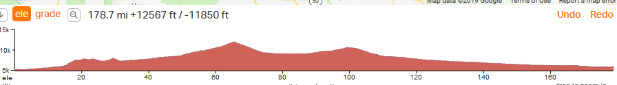
First glance it looks harmless.
 You can zoom in on the profile for more detail. What I usually do is break the whole route up into days. I have one route for each day.,
What I would love to see is a bit of AI to route for the least climbing (or most if that is what floats your boat
 .) . For example there are at least two routes around here that I can think of off the top of my head, that can be very hilly. But just go out of your way a few miles and you avoid the climbing. For me no big deal either way because I am used to these hills. But for someone from the flat lands with not much experience a very big deal.
Sort of an example is the GAP. Now if you want to go to Cumberland from here, Google will take you that way but I think that is because it is car free. If the GAP was a road then Google might actually take you on route 30 which is much shorter but extremely hilly.
Last edited by spinnaker; 08-02-19 at 08:29 PM.
08-02-19, 09:17 PM
#17
Every day a winding road
Thread Starter
@spinnaker OK... but I still don't know what "RWGP" is. I just googled "RWGP elevation" and nothing comes up. What app or site is it?
https://ridewithgps.com/
There is also Strava which will give you heat maps
https://www.strava.com/
08-02-19, 10:43 PM
#18
Mad bike riding scientist
Join Date: Nov 2004
Location: Denver, CO
Posts: 27,434
Bikes: Some silver ones, a red one, a black and orange one, and a few titanium ones
Mentioned: 153 Post(s)
Tagged: 1 Thread(s)
Quoted: 6255 Post(s)
Liked 4,280 Times
in
2,398 Posts
The route would still be better from west to east.
__________________
Stuart Black
Plan Epsilon Around Lake Michigan in the era of Covid
Old School�When It Wasn�t Ancient bikepacking
Gold Fever Three days of dirt in Colorado
Pokin' around the Poconos A cold ride around Lake Erie
Dinosaurs in Colorado A mountain bike guide to the Purgatory Canyon dinosaur trackway
Solo Without Pie. The search for pie in the Midwest.
Picking the Scablands. Washington and Oregon, 2005. Pie and spiders on the Columbia River!
Stuart Black
Plan Epsilon Around Lake Michigan in the era of Covid
Old School�When It Wasn�t Ancient bikepacking
Gold Fever Three days of dirt in Colorado
Pokin' around the Poconos A cold ride around Lake Erie
Dinosaurs in Colorado A mountain bike guide to the Purgatory Canyon dinosaur trackway
Solo Without Pie. The search for pie in the Midwest.
Picking the Scablands. Washington and Oregon, 2005. Pie and spiders on the Columbia River!
Likes For cyccommute:
08-03-19, 09:23 AM
#19
Banned.
I was just pointing the OP to a site for some research. On the website there is the Double Bypass which is the OP's exact route.
08-03-19, 04:37 PM
#20
Full Member
Join Date: Nov 2016
Location: SoCal
Posts: 489
Bikes: 2014 Bruce Gordon Rock&Road, 1995 Santana Visa Tandem, 1990 Trek 520, 2012 Surly LHT
Mentioned: 3 Post(s)
Tagged: 0 Thread(s)
Quoted: 211 Post(s)
Likes: 0
Liked 43 Times
in
35 Posts
As someone noted above I would also recommend a west to east route. Out of Denver you start climbing almost right away. Starting out of Glenwood Springs though I think you can take 3 easy days with a steady but never steep or long climb to Vail. Another reason is I think it better to go over Loveland Pass (US 6) west to east; its 32 miles between hotels in Dillon and Georgetown and 3,160; climb west to east and 3,760' east to west. Most of the time you don't really notice the interstate and most cars take the interstate as its the fastest way for them. Will have some "local" travel on the parallel road but I don't think it terrible. Are you thinking of taking the train from Denver and Glenwood Springs (returning to starting point); I ask because I am pretty sure bicycles can be taken in baggage car without being in a box on that route.
08-04-19, 12:57 AM
#21
Banned.
I am skeptical. I think "if" you "had" to pick one of two ways to do it, then yes, west down is the better idea.
But I am still skeptical even descending a lot, with the wind at your back most of it, that someone coming from sea level can just hop on a bike and climb back out of the Rockie Mountains, especially since someone said they are climbing over 11,000 feet. That just doesn't even sound realistic. I had some family come in from New York once and I took them to the top of a 14'er that you can drive up. They literally didn't even have to take a step to do any of it. They got out of the car and I told them to be cool and not go far. They walked around for a bit and I thought they were going to pass out. Then I am sure there are folks that can come out and here and do just fine. But I recall OP saying that he was still going through the mental stages of riding or pushing himself kind of thing, and this isn't the best place to figure out if you are mentally and physically tough enough if you are questioning yourself in other places. I am not trying to pee in anyone's cheerios, but I like to try and be realistic. I also wouldn't tell someone to "not" do something as if the mountain is too big for them kind of thing. Folks should push and challenge themselves, so I am not trying to psyche anyone out of anything. If there is a mountain there for you to personally climb, go climb it is my motto. But be smart about it is all. I would personally worry about going up over 11,000 feet and I live at 5,600 now. All I am saying is be real with yourself and the variables at play. There is still plenty of ways to enjoy Denver, the mountains, and even incorporating biking into all of it for anyone's ability or level. I also don't think people understand how long some of this ascending and descending can actually be too.
If you are a natural athlete in some capacity, then I would say taking the gamble with altitude sickness isn't such a big deal. But if you are not then some of it might be really pushing your limits from what could be an amazing trip to just being miserable and winded constantly. Especially if you catch a headwind along the way, which you are cutting through canyons that the Rocky Mountains are literally escaping their winds down those corridors to burst out into the front range...so chances are pretty good you might hit one at some point if you catch a tough day.
I do like and would also suggest about what cyccommute said. I wouldn't have thought of that. Just be realistic with yourself though is all. You could always just get here, and push yourself really hard one day riding around metro Denver, even riding out to Golden and back down. Some of that will give you a slight test and idea of what to expect on your lungs. When you do go on the trip you are suggesting, you will climb up over passes, but you won't be at those altitudes for long periods of times. Ride really hard one day in metro and see how your body and head responds. If you are good doing that, and you will know if you are in tune with yourself, then you can do what cyccommute said the next day. At least you will descend a lot more naturally and will have the winds at your back for the most part if the jet streams are cooperating from his suggestion. DRINK LOTS OF WATER. Not just cycling. The entire time you are here. Drink so much water your pee looks like water. Not only are you at higher altitude but you are in desert environment for the most part. It's beautiful, sunny, dry, and your body isn't use to it all and you can lose focus on hydrating easily. You need to hydrate a lot, especially if you plan on a bike ride like that.
I might even personally do what cyccommute said and just start doing some more trips like that personally. That's actually an incredible and wonderful idea and just opened up some more stuff for me personally to go do or conquer. So thanks for the idea!
Last edited by Bike Jedi; 08-04-19 at 10:19 AM.
08-04-19, 09:52 PM
#22
Full Member
Join Date: Nov 2016
Location: SoCal
Posts: 489
Bikes: 2014 Bruce Gordon Rock&Road, 1995 Santana Visa Tandem, 1990 Trek 520, 2012 Surly LHT
Mentioned: 3 Post(s)
Tagged: 0 Thread(s)
Quoted: 211 Post(s)
Likes: 0
Liked 43 Times
in
35 Posts
As to whether anyone from sea level can cycle Colorado without x days of acclimation my experience shows it can be done. In 2013, when I was 55 and not in the best shape of my life, I went to see the US Pro Challenge Race (when it was still 7 days). I drove from sea level (Los Angeles) to Carbondale Colorado (6,200'), just up valley from Glenwood Springs, in 36 hours. Next day (1st full day at altitude) I biked to Aspen (elevation 8,000 feet) to see the race, then started part way up Independence Pass to camp (probably 9,000'). Next day I crossed Independence Pass (12,095'), and stayed with friends in Leadville. Independence Pass was by far the hardest day for me but I have really low gears and just ground my way up. So essentially in 4 days I went from sea level to 12,095', Maybe the question is how strong a rider you are to begin with.
08-05-19, 05:46 AM
#23
Senior Member
Join Date: Feb 2012
Location: Golden, CO and Tucson, AZ
Posts: 2,849
Bikes: 2012 Specialized Elite Disc, 1983 Trek 520
Mentioned: 13 Post(s)
Tagged: 0 Thread(s)
Quoted: 681 Post(s)
Liked 755 Times
in
435 Posts
I'm a local and I ride to and over the Divide fairly often, on tours and day trips. I have a friend in Breckenridge and ride over to his house on the first day. So I don't have any lodging experience in the area. I think it's pretty expensive.
I strongly agree with the suggestion to reverse your direction. If you do that, I think your most difficult day would be between Keystone and Georgetown. If weather cooperates and you have a good morning to climb Loveland Pass, and you've slowly acclimated over several days, you stand a good chance.
You'd also want to stay in Vail to get in good position to climb Vail Pass on a nice morning.
I think someone has already mentioned the usual afternoon thunderstorms in the Rockies. The high passes are not a good place to be in the afternoon.
One of the harder climbs for me mentally is Floyd Hill, heading east out of Idaho Springs. It's a 1000' grind on the shoulder of US 40 at the end of the day. You may want to plan a night in Idaho Springs and tackle that one in the morning as well. The grade and elevation aren't hard.
The steepest grade is a short climb on the new MUP between Chief Hosa and Evergreen. That's easy to walk if you need to.
06-25-21, 07:35 PM
#24
Member
Join Date: Sep 2013
Posts: 28
Mentioned: 0 Post(s)
Tagged: 0 Thread(s)
Quoted: 11 Post(s)
Likes: 0
Liked 9 Times
in
4 Posts
I did this trip last week. Flew to Denver, took Amtrak to Glenwood Springs, and the bus to Basalt. Rode Basalt to Eagle, Eagle to Frisco, Frisco to Idaho Springs, stayed over a night in IS and went up Mt Evans, and then next day on to Denver, Five days of riding on one day of acclimating.. Tough but beautiful ride. Did it credit card bikepacking style on a gravel bike.
Likes For mbailey:
06-27-21, 11:23 AM
#25
Newbie
Join Date: Feb 2017
Posts: 34
Mentioned: 0 Post(s)
Tagged: 0 Thread(s)
Quoted: 10 Post(s)
Likes: 0
Liked 2 Times
in
1 Post
You might want to think about going further north: ~10 yrs ago I flew into Denver, took the bus up to Lyons, then rode to Estes Park, up through RMNP, then followed the Colorado (more or less) through Granby, Hot Sulphur Springs, Kremling. I don�t remember my exact route from there (pre-gps) but I think I joined I-70 in Wolcott.
I�ve never ridden the I-70 corridor so don�t know how it compares but I remember this ride being lovely (especially the climb through the park) and feeling pretty safe. I was coming from sea level (PDX) and gave myself a day in Denver and a day of riding from Lyons to Estes Park before the real elevation gain. I�ve done a fair bit of climbing in the cascades; altitude impacts vary so much from person to person�it�s a good sign if you were ok going from sea level to 11k feet in 12 hrs climbing hood; at the same time spending many hours or even days at elevation can have a really different impact.
I�ve never ridden the I-70 corridor so don�t know how it compares but I remember this ride being lovely (especially the climb through the park) and feeling pretty safe. I was coming from sea level (PDX) and gave myself a day in Denver and a day of riding from Lyons to Estes Park before the real elevation gain. I�ve done a fair bit of climbing in the cascades; altitude impacts vary so much from person to person�it�s a good sign if you were ok going from sea level to 11k feet in 12 hrs climbing hood; at the same time spending many hours or even days at elevation can have a really different impact.