Is a loop possible across the GWB and back across the Cuomo Bridge?
 09-29-20, 06:48 PM
#1
Senior Member
Thread Starter
Is a loop possible across the GWB and back across the Cuomo Bridge?
I've done the ride many times across the GWB to Nyack and above but with the new bridge in place I'm wondering if a loop is possible that doesn't end up on major roads. Using the S. County trail would be nice but if I can't get through VC Park it isn't an option. And what would be the best way to get to the S. County from the bridge. RWGPS put me on Rt 119 which isn't cycling friendly looking although it takes you directly to Elmsford where the trail used to start after having to go through that miserable town. Not sure if any other way is good. Is the VC Park section open? The website says 99% done, but the 1% could still be barriers that prevent usage. I know the way from VC Park to the bridge without problem. Projected completion date of the trail is Oct, 2020, and it will be October by the time I do this ride. My adult daughter is joining me on this and I don't want it to be too hard either. GWB, River Rd, 9W to Piermont, Nyack (Runcible? another thread.), the new bridge, and then down back to the GWB. I'm going to drive to the bridge to avoid the extra 18 miles each way through the streets of Brooklyn and Manhattan.
Any route suggestions in Westchester would be appreciated.
Any route suggestions in Westchester would be appreciated.
 09-29-20, 07:40 PM
#2
Senior Member

You could take 9 north to Tarrytown, and climb Nepheran to meet the NC Trailway in Eastview. Or take 9 south to Wharburton through Yonkers to Riverdale. BTW if you go th the Runcible you'll have ridden past the the new bridge entrance
09-29-20, 09:59 PM
#3
Senior Member
Thread Starter
If I do the loop I'd skip the Runcible and stop in Piermont instead. There are a few places there. Nepheran looks like it could be good. I'd rather stay away from Yonkers and Riverdale streets. Is the VC park trail section open? And if not, is McLean to Broadway the best way to go? I want Broadway anyway for the bridge to Manhattan. It's fine to ride until you get under the el.
09-30-20, 12:14 PM
#4
Senior Member

From a Facebook page
Important Notice! Please stay off of the Putnam Trail within Van Cortlandt Park tomorrow, Tuesday 9/29, for your safety as the contractor puts the striping on the path.
Help NYC Parks put the final touches on the Putnam Greenway!
Volunteer in the park on Tuesday, September 29 – anytime from 7 am to 5 pm. Email info@vancortlandt.org for link to sign up.
NYC Parks and Van Cortlandt Park Alliance are looking for volunteers to keep all pedestrians and cyclists from entering the Greenway as the contractor puts the striping on the path.
Your help will keep people safe (the machinery is extremely HOT and dangerous) and it will make the job go faster. Volunteers will be posted at locations outside the project area to let park users know that the trail is off limits for the day.
Updated: They were not able to complete it today because of the rain so they will be back at it again tomorrow. Please stay off the trail again on Weds. 9/30. Thank you!
Going to have to do a recon and see if the gates are open?
After you come off the Commo Bridge on the Tarrytown side the fastest way to the South County Trail is Rt.119 and enter in Elmsford, it's 2.5 miles about and not so bad.
To go North on Route 9 and climb Neperan Ave is longer in traffic
09-30-20, 04:57 PM
#5
Senior Member
Join Date: Jul 2007
Location: South shore, L.I., NY
Posts: 7,020
Bikes: Flyxii FR322, Cannondale Topstone, Miyata City Liner, Specialized Chisel, Specialized Epic Evo
Mentioned: 18 Post(s)
Tagged: 0 Thread(s)
Quoted: 3326 Post(s)
Liked 2,171 Times
in
1,231 Posts
Curious if you have actually ridden Rt 119 ?. It's 4 lanes - 2 each way, no shoulder for most of it, traffic does 50mph easy. I'd take Neperan or head south on Rt 9 (also suck) a mile, then Sunnyside Lane/Taxter Rd. east (also hilly) to Rt 119 for 1/2 mile to the SCT.
09-30-20, 05:32 PM
#6
Senior Member
If your riding from the GW bridge up 9W to Nyack you're in worse traffic then Rt 119. I remember last time I rode up that route right around Grandview I think it is near the end when you get a good view off the bridge I got buzzed by a tracker trailer so close the draft almost knock me off the bicycle
Last edited by Jarrettsin; 09-30-20 at 05:39 PM.
09-30-20, 08:58 PM
#7
Senior Member
Thread Starter
I've done 9w many times and it isn't nearly as bad as 119 looks in streetview. There is no shoulder on 119 at all. 9w has a shoulder, but we all also know to stay off that section by Grandview. You take River Road there, which is how I intend to go tomorrow. I'm going to take Neparin. Also, when I looked at my route it has me go on a small trail around Tarrytown Reservoir. Is that paved or dirt or gravel? We'll be on road bikes. If it is hard packed it'll be ok but not loose gravel.
10-01-20, 04:37 AM
#8
Senior Member
small trail around Tarrytown Reservoir. Is that paved or dirt or gravel?
10-01-20, 11:07 AM
#9
Senior Member
If I do the loop I'd skip the Runcible and stop in Piermont instead. There are a few places there. Nepheran looks like it could be good. I'd rather stay away from Yonkers and Riverdale streets. Is the VC park trail section open? And if not, is McLean to Broadway the best way to go? I want Broadway anyway for the bridge to Manhattan. It's fine to ride until you get under the el.
10-01-20, 04:41 PM
#10
Senior Member
Thread Starter
OK, I did the ride today with my daughter as planned. Here's a quick ride report:
First off, we started at the VC Park parking lot at the start of the trail. We drove up from Brooklyn as I couldn't do an 85 mile ride with my daughter, she wouldn't do it. At least since we started there we could see the status of the trail through the park, and it was still fenced off. So we went down Bailey Ave as planned and then over to Broadway, Bailey isn't a bike lane but there isn't much traffic, and then took Seaman Ave through Inwood and Broadway again from Dyckman to the bridge. Normally I'd take the greenway but I didn't want to do the steep climb from there.
The bridge was the same still. On the NJ side we took River Rd - Henry Hudson Parkway down under the bridge. After the first steep climb at the picnic area the road is closed, but we took it anyway and it was fine. They were cleaning up from an earlier storm it seemed and it could have been opened except for one or two trees that jutted into the road. I climbed Alpine hill in my new 34/29 gear with ease, but my daughter walked some. (I'm on my CF road bike and she is on a Cannondale Criterium from the late 80s that I fixed up for her. It is a great bike but it still has the 6sp on it and it shifts like crap.) Took 9W and then the Tallman park trail into Piermont. The Tallman trail is hard packed dirt, ok for a road bike.
From Piermont we worked our way to the new Mario Cuomo bridge. The bridge is nice, wide enough in spite of what I've read about it. There are a few places to pull off and take in the view, with benches and bike stands. At the end there is actually a little plaza, with bathrooms. I took 9 up to Neperin and that was too steep for her, and once I stopped I couldn't get enough momentum going to click back in and I walked it too. It is short though, no big deal at all. We got back on and went to the trail that skirts the south side of the reservoir there, that is paved as promised by Jarretsin. It ends and you are on a road for a few hundred feet, if that, and then you see a bike route sign to the left, that is the entrance to the North County trail. The North County becomes the South County in Elmsford, which is blessedly bypassed now. At some point there was a sign that said the trail was closed one mile ahead, but we rode it anyway and it was open. There was construction but they maintained the trail. There was also another place with a sign that pointed away from the trail to go south but we ignored that one too and there was nothing there.
That brings us back to The Bronx. At the end of the S. County you come to a fence, but there is a giant hole in it, with a barrier you can climb right over. If you have to you could probably just lift your bike over by yourself, but having 3 people we just passed them over (the third was just a random rider looking to do the same.) The new trail is nice, even though I actually like the old dirt trail. At the VC park end though there is no way out at the very end. You have to go back some beyond where the construction fence is and there is a hole in an old fence where you can go out. From there we went back to the car, where my daughter noted we had done 48.3 miles and wanted to do a full 50, so we went on another trail that takes you out to Mosholu Pkwy and then back. An even 50!
It was a nice ride and we both enjoyed it. What we didn't enjoy were the massive traffic jams everywhere we went on the way home. That truly sucked.
Likes For zacster:
10-11-20, 06:04 PM
#11
Member
Join Date: Jun 2017
Location: LI south shore
Posts: 29
Bikes: Specialized Tarmac Comp Disc Ultegra, Specialized Roubaix SL4 Comp, Specialized Fat Boy, trek Superfly FS9, Cannondale R400, Specialized StumpJumper
Mentioned: 1 Post(s)
Tagged: 0 Thread(s)
Quoted: 12 Post(s)
Likes: 0
Liked 0 Times
in
0 Posts
Can any of you local folks post either a strava or ridewithgps link to a good route for a loop on the GWB and Tappan Zee? Starting anywhere, doesn't matter.
Thank you in advance!
/Ed
Thank you in advance!
/Ed
10-11-20, 10:17 PM
#12
Senior Member
Thread Starter
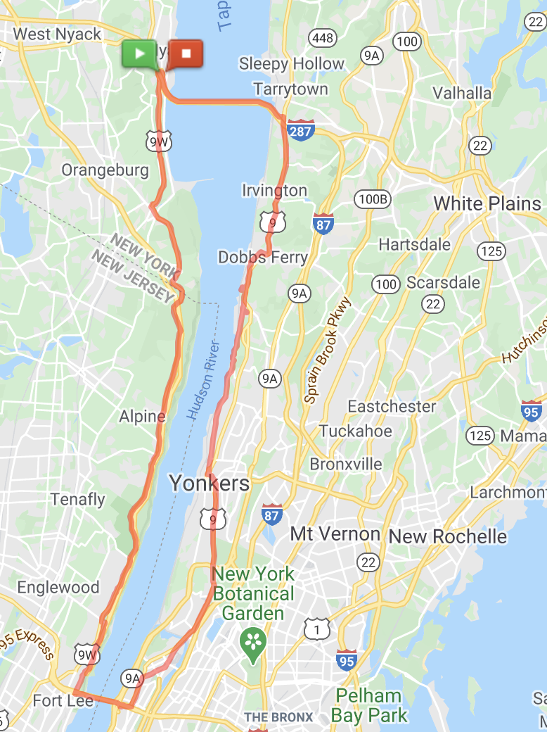
GWB - Cuomo bridge route
That was the route I followed. I think the part crossing the Broadway Bridge is a little messed up but the rest should be good. Sometimes you just can't get RWGPS to take the roads you want.
I also took the trail through Tallman St Park into Piermont instead of the route shown. Either should work.
Neperin Road in Tarrytown is steep! When you get to the top there is a trail at Sunnyside Ave that you take. You could easily miss it. At the end of that trail you are on the road for about 100 feet and you'll see another bike route sign across the road, you take that trail too and that is the N. County trail entrance. It is downhill most of the way to The Bronx from there. But you can see that on the RWGPS map. Use the street view to see these.
My daughter complained after the ride that she found the N/S County trail boring. There is really not much to see once you are on it, but at least you are off the streets.
And the Putnam trail, the part through Van Cortland Park, is now fully open.
In normal times I'd ride up from Brooklyn, do the loop, and then take the subway from Upper Manhattan, but I don't do subway anymore.
Last edited by zacster; 10-11-20 at 10:44 PM.
10-12-20, 01:41 PM
#13
Senior Member
I also took the trail through Tallman St Park into Piermont instead of the route shown. Either should work.
10-12-20, 02:16 PM
#14
On Your Left

Join Date: Nov 2011
Location: Long Island, New York, USA
Posts: 8,373
Bikes: Trek Emonda SLR, Sram eTap, Zipp 303
Mentioned: 34 Post(s)
Tagged: 0 Thread(s)
Quoted: 3004 Post(s)
Liked 2,434 Times
in
1,187 Posts
My son used to do Riverdale to the GW, north on 9W to the Bear Mtn and then south to Riverdale.
10-12-20, 02:19 PM
#15
Senior Member
Take route 9 on the NY side and route 9W on the NJ side. They both intersect with both bridges.
10-12-20, 02:36 PM
#16
Senior Member
Thread Starter
Yes, you go into Tallman and just follow the trail and you'll come out in Piermont. You then follow the road along the river up to Nyack or the new bridge. Grandview was always considered too dangerous to ride on 9W.
10-12-20, 02:40 PM
#17
Senior Member
Thread Starter
That's not a great route, at least Rt 9 on the Westchester side. 9W is OK but stay away from Grandview, go down into Piermont instead and ride along the river. Coming from the GW bridge take Hudson Terrace to the end before you get onto 9W. It is just a better place to ride. You'll see a lot of cyclists doing that.
Likes For zacster:
10-12-20, 03:01 PM
#18
Senior Member
Join Date: Jul 2007
Location: South shore, L.I., NY
Posts: 7,020
Bikes: Flyxii FR322, Cannondale Topstone, Miyata City Liner, Specialized Chisel, Specialized Epic Evo
Mentioned: 18 Post(s)
Tagged: 0 Thread(s)
Quoted: 3326 Post(s)
Liked 2,171 Times
in
1,231 Posts
That's not a great route, at least Rt 9 on the Westchester side. 9W is OK but stay away from Grandview, go down into Piermont instead and ride along the river. Coming from the GW bridge take Hudson Terrace to the end before you get onto 9W. It is just a better place to ride. You'll see a lot of cyclists doing that.
Better to take Nepperan Ave or Sunnyside/Taxter over to the North/South County trail, as zacster has done.
10-12-20, 05:23 PM
#19
Senior Member
That's not a great route, at least Rt 9 on the Westchester side. 9W is OK but stay away from Grandview, go down into Piermont instead and ride along the river. Coming from the GW bridge take Hudson Terrace to the end before you get onto 9W. It is just a better place to ride. You'll see a lot of cyclists doing that.
10-12-20, 08:01 PM
#20
Member
Join Date: Jun 2017
Location: LI south shore
Posts: 29
Bikes: Specialized Tarmac Comp Disc Ultegra, Specialized Roubaix SL4 Comp, Specialized Fat Boy, trek Superfly FS9, Cannondale R400, Specialized StumpJumper
Mentioned: 1 Post(s)
Tagged: 0 Thread(s)
Quoted: 12 Post(s)
Likes: 0
Liked 0 Times
in
0 Posts
Thank you VERY much! Will ride that soon!
/Ed
/Ed
10-13-20, 10:41 AM
#21
Senior Member
Thread Starter
Hudson Terrace does not have a big climb back to 9W. You must be thinking of Henry Hudson Parkway aka River Rd. which does have the climb in Alpine at the end back up to 9W. I used Henry Hudson Pkwy to do this ride, but I've gone up Hudson Terrace many times as well, and usually take it when going to 505 if I want to go that way too. I rode up Alpine hill with ease in a 34/29 gear, but my daughter walked it partway as she isn't a real rider. It wasn't like I was waiting a half hour for her, just a few minutes. Our agreement was that I'd ride up any hills and wait at the top. I had to walk on Neperan in Tarrytown because she was in front of me and I had to stop when she did and I couldn't get going again because it was too steep.
10-13-20, 10:50 AM
#22
TeeOhPea 2tha DeeOhGee
I've done the ride many times across the GWB to Nyack and above but with the new bridge in place I'm wondering if a loop is possible that doesn't end up on major roads. Using the S. County trail would be nice but if I can't get through VC Park it isn't an option. And what would be the best way to get to the S. County from the bridge. RWGPS put me on Rt 119 which isn't cycling friendly looking although it takes you directly to Elmsford where the trail used to start after having to go through that miserable town. Not sure if any other way is good. Is the VC Park section open? The website says 99% done, but the 1% could still be barriers that prevent usage. I know the way from VC Park to the bridge without problem. Projected completion date of the trail is Oct, 2020, and it will be October by the time I do this ride. My adult daughter is joining me on this and I don't want it to be too hard either. GWB, River Rd, 9W to Piermont, Nyack (Runcible? another thread.), the new bridge, and then down back to the GWB. I'm going to drive to the bridge to avoid the extra 18 miles each way through the streets of Brooklyn and Manhattan.
Any route suggestions in Westchester would be appreciated.
Any route suggestions in Westchester would be appreciated.
Yes.