


Blazing a New Route - How Would YOU Do It?
 10-24-21, 02:08 PM
#51
Senior Member
Join Date: Apr 2010
Location: Elevation 666m Edmonton Canada
Posts: 2,570
Bikes: 2013 Custom SA5w / Rohloff Tourster
Liked 368 Times
in
274 Posts
Why would I trust a stupid app to give me a route?? I sure aren't going to ride some gravel goat trail.
I do admit I'm poor at finding tourist spots I should have gone to. Sometimes I just forget to turn.
Obviously I have an overall destination, but basically I just plan the next day, while lying on the motel bed with my I-pad. Lots of forks in the road, I just eyeball it and check it out on my phone map.
The border bouncer asked me where I was going and I said how the hell should I know?? I then said being in my car would be the same.
I try to pick the most scenic route, hopefully with the best shoulders. Some days it's just ride to the next city. I actually choose to be in big cities along the way. Weather has some influence, not much. When I was going from Chilliwack to Vancouver, I didn't feel like picking my way thru the suburbs 90 miles. So I just got on the TransCan freeway, just 62 miles. LOL
Same thing in Vietnam and China.
Last edited by GamblerGORD53; 10-24-21 at 02:16 PM.
 10-24-21, 02:14 PM
#52

2-Wheeled Fool
Thread Starter

Join Date: Sep 2016
Location: New Hampshire
Posts: 2,346
Bikes: Surly Ogre, Brompton
Liked 677 Times
in
457 Posts
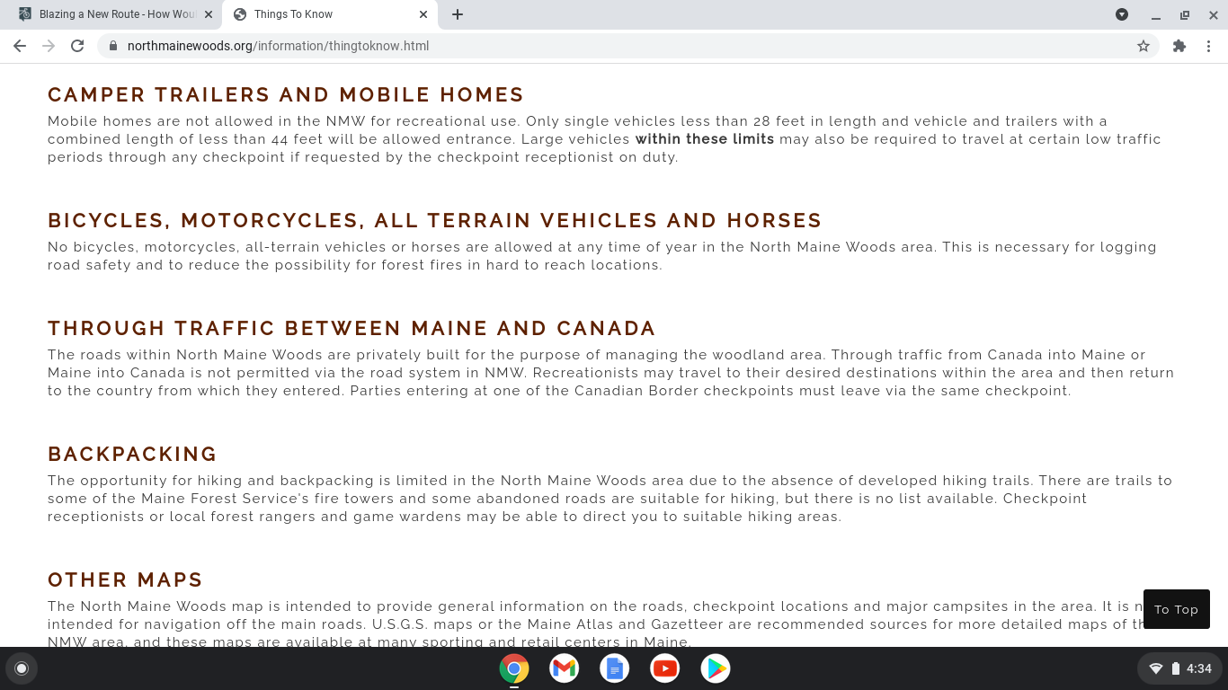
Well here's a wrinkle. Your route has you cycling on roads in the North Maine Woods. You cannot ride a bike on these roads. Its stated on their website
"No bicycles, motorcycles, all-terrain vehicles or horses are allowed at any time of year in the North Maine Woods area. This is necessary for logging road safety and to reduce the possibility for forest fires in hard to reach locations."
"No bicycles, motorcycles, all-terrain vehicles or horses are allowed at any time of year in the North Maine Woods area. This is necessary for logging road safety and to reduce the possibility for forest fires in hard to reach locations."

Likes For J.Higgins:
10-24-21, 02:24 PM
#53
Senior Member
10-24-21, 02:26 PM
#54
Senior Member
It'll be one or the other for sure (inReach, or the sat-phone). Both would be nice, but the inReach would get used much more I believe. Still, if I want to use the inReach to the limit of its abilities, I would need to pay a monthly satellite subscription, which I wouldn't want.
I'll be bringing either my flyrod or my tenkara rod. We've spent a lot of time on remote streams and flowages resulting from beaver activity. I've caught a lot of trout in small waters like that. Good way to catch your supper and give you some much-needed nutrients along the way. I carry some foil, folded and tucked away. I'll clean a fish and wrap a slice of bacon around it and wrap it up in foil and cook it by the fire. Good stuff! I like using that method because the flesh of the fish is firm, but not dry, and the bacon adds just the right amount of seasoning. Sometimes I add a few leaves of sheep sorrel or dandelion greens that I find along the way.
I'll be bringing either my flyrod or my tenkara rod. We've spent a lot of time on remote streams and flowages resulting from beaver activity. I've caught a lot of trout in small waters like that. Good way to catch your supper and give you some much-needed nutrients along the way. I carry some foil, folded and tucked away. I'll clean a fish and wrap a slice of bacon around it and wrap it up in foil and cook it by the fire. Good stuff! I like using that method because the flesh of the fish is firm, but not dry, and the bacon adds just the right amount of seasoning. Sometimes I add a few leaves of sheep sorrel or dandelion greens that I find along the way.
 10-24-21, 02:56 PM
#56
2-Wheeled Fool
Thread Starter
Join Date: Sep 2016
Location: New Hampshire
Posts: 2,346
Bikes: Surly Ogre, Brompton
Liked 677 Times
in
457 Posts
I used to just crumple it up and bury under a rock when I was a teenager. Then I grew up and began to pack it out. A couple of times I had critter problems. One raccoon, and mice. After the mouse incident, which is a whole 'nother story all by itself, I began to burn the foil in the fire. Next morning, I'd pull out any foil remaining unburned. I've never had an issue with any bears, but I don't want to either. I hang my food even when I am camping in a campground (if possible).
 10-24-21, 04:32 PM
#58
Senior Member
even without knowing anything about restricted access etc, when I saw your route, all I could think about is , wow that looks pretty darn remote.
I'm sure you can find other trail routes in the (sort of) area. I recall a couple of Vermont trail routes, names I cant think of right now, they've been discussed here in the past, but I cant recall the details.
One of them is a much tougher one, I'll try to remember or search for it---if however, a bikepacking route appeals to you, more for the adventure aspect of it, and not just going into the north Maine area specifically.
There has to be a bunch of fun offroad routes that folks have been documenting over the last 5 years or so.
What about the Divide route? Or part of it?
oh, and yes, the 2.5 Extraterrestrials are an interesting tire.I have a pair but really havent used them that much, just because I havent done trips that they would be appropriate for.
A friend used them when he did about half of the Divide Trail, and found them a good mix for the surfaces and still going ok on paved roads also. He did this in 2017 and I would have loved to have done it with him, but was just back from a long bike trip and couldnt be away again for a few months. He did it on a Troll and some panniers, and it worked well all in all.
I have a Troll also, and it and the Ogre are great, versatile bikes. I'm keen still on 26" and anyway, I have teh bike and it could go anywhere, just with a change of tires pretty much.
ps, you having good bike mechanic skills and hiking experience is a huge plus obviously for these types of trips. Some folks come on here with great ideas but with really little or no experience, and often seem to be biting off more than they can chew, or simply are being realistic about doing a given trip, or at least doing without a whole bunch of potential things that can go south due to not having real experience.
10-24-21, 04:51 PM
#59
Senior Member
Join Date: Jul 2007
Location: South shore, L.I., NY
Posts: 7,317
Bikes: Flyxii FR322, Cannondale Topstone, Miyata City Liner, Specialized Chisel, Specialized Epic Evo
Liked 2,397 Times
in
1,353 Posts
Options are head east from NW Maine towards the I95 corridor. There are a LOT of dirt roads outside of the North Maine Woods owned property. Or go up into Quebec and stay close to the US border. Sorry to be the bad news bearer.
10-26-21, 08:18 AM
#60
Senior Member
Join Date: Sep 2015
Location: QC Canada
Posts: 2,050
Bikes: Custom built LHT & Troll
Liked 167 Times
in
120 Posts
I've been considering just simply renting a sat phone from Verizon for a month. Expensive, but if I can get into a rental that doesnt screw me over by making me commit to a year subscription or something, then I'll be alright. This is an expensive phone for the relatively short duration of this trip, but will pay back in spades the amount of comfort and security it will bring. https://www.vzwsatellite.com/product...al/iridium9575 Your thoughts?
2. instead of a sat phone, consider a sat messenger such as Garmin's inReach mini. The devices sets you back $400 + monthly network access at something like $15/month. Much more rugged, energy efficient, and convenient than a sat phone.

Likes For gauvins:
10-26-21, 09:11 AM
#61
Full Member
Join Date: Sep 2017
Location: Lisle, IL
Posts: 408
Bikes: 2003 Litespeed Vortex, 2017 All-City Mr. Pink, ~1997 Trek Multitrack 700
Liked 99 Times
in
59 Posts
2. instead of a sat phone, consider a sat messenger such as Garmin's inReach mini. The devices sets you back $400 + monthly network access at something like $15/month. Much more rugged, energy efficient, and convenient than a sat phone.
Last edited by GadgetGirlIL; 10-26-21 at 09:24 AM.
10-26-21, 11:24 AM
#62
Senior Member
Join Date: Sep 2007
Location: Far beyond the pale horizon.
Posts: 14,576
Liked 1,498 Times
in
1,037 Posts
10-26-21, 03:01 PM
#63
Senior Member
10-26-21, 03:10 PM
#64
Senior Member
Join Date: Sep 2007
Location: Far beyond the pale horizon.
Posts: 14,576
Liked 1,498 Times
in
1,037 Posts
I was commenting on staehpj1 taking it as serious (apparently). Funny or not. it was clearly absurd. Funny or not, it should have been treated as absurd (not as a serious suggestion).
10-27-21, 05:46 AM
#66
Senior Member
Any way I finally decided it was an unexplainable, but apparently successful attempt at trolling since here we are still discussing it.
10-27-21, 07:03 AM
#68
Senior Member
Join Date: Sep 2007
Location: Far beyond the pale horizon.
Posts: 14,576
Liked 1,498 Times
in
1,037 Posts
I looked at it and thought. Hmm, I don't see any humor, but this doesn't make sense in a touring context. I breifly entertained the notion that in some context it might make sense (difficult single track?), but quickly dismissed that. I thought just maybe I was missing the joke. That does happen especially since there are forms of humor that I don't find particularly funny. I usually at least recognize them as humor though.
Any way I finally decided it was an unexplainable, but apparently successful attempt at trolling since here we are still discussing it.
Any way I finally decided it was an unexplainable, but apparently successful attempt at trolling since here we are still discussing it.
10-27-21, 07:04 AM
#69
Senior Member
Join Date: Sep 2007
Location: Far beyond the pale horizon.
Posts: 14,576
Liked 1,498 Times
in
1,037 Posts
10-27-21, 07:53 AM
#70
Senior Member
Join Date: Dec 2010
Location: northern Deep South
Posts: 9,156
Bikes: Fuji Touring, Novara Randonee
Liked 2,159 Times
in
1,328 Posts
John Ciardi suggested using -) to represent "tongue in cheek" back in the early 1970s. That was before emoticons were a thing -- I think it even predated the original smiley face, so as I remember he had to take half a column to explain the dash was the tongue, and the parenthesis represented the cheek bowed out by the tongue pressing on the inside of the cheek.
10-27-21, 12:06 PM
#71
Just call me Carrie

And...I just read through the rest of the thread. Nevermind, J, I'll stay home, then.

Have you looked into the railroad trails down in Mass?
__________________
I was going to have a good signature but apparently I'm too verbose.
I was going to have a good signature but apparently I'm too verbose.
Last edited by TriBiker19; 10-27-21 at 12:16 PM.
Likes For TriBiker19:
10-27-21, 12:08 PM
#72
Junior Member

I like using the gazetteer style paper book maps by DeLorme, which are in a very large scale and show logging/dirt roads and hiking/biking trails as well as contour lines/topography, all of which would seem useful for the type of adventure you're planning. If you google "gazetteer map" + the state(s) you want you should get results.
By the way, one of my cycling calendars, had a quote to the effect of, "be careful when looking for adventure, it's ridiculously easy to find."
By the way, one of my cycling calendars, had a quote to the effect of, "be careful when looking for adventure, it's ridiculously easy to find."
10-27-21, 02:08 PM
#73
2-Wheeled Fool
Thread Starter
Join Date: Sep 2016
Location: New Hampshire
Posts: 2,346
Bikes: Surly Ogre, Brompton
Liked 677 Times
in
457 Posts
I'll do a day with you! Heck, I can bring my little chatterbox with me and he can keep us both entertained. (And warn about any roots/muddy areas/random things on the side of the trail that we might have missed...sometimes he complains, though, but not often.)
And...I just read through the rest of the thread. Nevermind, J, I'll stay home, then.
Have you looked into the railroad trails down in Mass?
And...I just read through the rest of the thread. Nevermind, J, I'll stay home, then.
Have you looked into the railroad trails down in Mass?

We love to ride the Winchendon Trail, and we've been going to to the Berkshires for a trail out there too. We did the Mason trail last weekend. Went all the way to that quarry I used to jump in when I was young and foolish. Now that I'm old and foolish, I know better!
10-28-21, 10:57 AM
#74
Just call me Carrie
You close your eyes before you jump now?
Mike as a chatterbox....only when he's had a couple of drinks. He's normally a pretty quiet guy. Great sense of humor, though, so I keep him around.
Mike as a chatterbox....only when he's had a couple of drinks. He's normally a pretty quiet guy. Great sense of humor, though, so I keep him around.
__________________
I was going to have a good signature but apparently I'm too verbose.
I was going to have a good signature but apparently I'm too verbose.
10-28-21, 12:04 PM
#75
Senior Member
I do my route recon with google maps and state atlases that are county based, then a final boots on the ground inspection by motorcycle. That allows me the opportunity to see the road conditions, width, shoulder width and traffic speed. When not followed by cars, I ride at a cycling pace, 18 to 20 mph. This can also draw out dogs so I make a mental note of where they are prior to using the new route. Knowing conditions/hazards ahead of time can really make a difference. It can also work for local/semi local touring you just have to have the time off to do it. Being retired makes it easy.
Last edited by nomadmax; 10-28-21 at 07:50 PM.