


Another Blue Ridge Parkway/Skyline Drive Thread
 08-16-17, 04:01 PM
#1

pan y agua
Thread Starter
Join Date: Aug 2005
Location: Jacksonville
Posts: 31,304
Bikes: Willier Zero 7; Merlin Extralight; Calfee Dragonfly tandem, Calfee Adventure tandem; Cervelo P2; Motebecane Ti Fly 29er; Motebecanne Phantom Cross; Schwinn Paramount Track bike
Mentioned: 17 Post(s)
Tagged: 0 Thread(s)
Quoted: 1447 Post(s)
Liked 728 Times
in
373 Posts
Another Blue Ridge Parkway/Skyline Drive Thread
Starting a ride of the length of the Parkway and Skyline Drive, South to North this Monday the 21st.
I'm going to set out my planning for the trip and experiences along the way in this thread, to the extent it might help others doing the Parkway and mostly as a way to collect my own thoughts,
Did a shakedown 50 mile ride today with the bike loaded with everything I plan to take. The bike I'm using a Merlin Extralight has no rack mounts, so my original plan was use a seat post mounted rack I already have.
Even though this is going to be a credit card tour carrying a limited amount of stuff, it was quickly obvious that the seat post rack was going to be suboptimal, holding the panniers too high, and not completely secure.
So I rode to the LBS and got a Blackburn Ex 1 Disc rack.
Top front is mounted by the brake bolt, and the bottom connects through a longer QR that replaces the wheel's QR lever, and provides a mount for the rack.
Riding home with the panniers lower, and secure was a definite improvement.
__________________
You could fall off a cliff and die.
You could get lost and die.
You could hit a tree and die.
OR YOU COULD STAY HOME AND FALL OFF THE COUCH AND DIE.
You could fall off a cliff and die.
You could get lost and die.
You could hit a tree and die.
OR YOU COULD STAY HOME AND FALL OFF THE COUCH AND DIE.
Last edited by merlinextraligh; 08-16-17 at 04:04 PM.
 08-16-17, 04:50 PM
#2
Senior Member

Join Date: Sep 2011
Location: Western Florida
Posts: 1,581
Bikes: 2017 Kona TI, 2016 Bike Friday Haul-A-Day, 2015 Bike Friday New World Tourist (for sale), 2011 Mezzo D9, 2004 Marin Mount Vision Pro - for now :)
Mentioned: 2 Post(s)
Tagged: 0 Thread(s)
Quoted: 103 Post(s)
Liked 5 Times
in
5 Posts
I've done that on my BMW a number of times and love the ride, peace, and beauty. I have thought of doing it on my bicycle, but wasn't sure how to get food as I couldn't carry enough for the whole trip and the ride down off the BRP and back up would likely do me in. How do you plan for you provisions?
08-16-17, 05:13 PM
#3
-

I hope you know there's going to be exceptional crowds and traffic in the area of Cherokee-US441-Gatlinburg and the Smokies in general on Monday, and probably less on Tuesday, for the solar eclipse. Plus everyone's trying to cram a vacation in before school starts.
https://visitcherokeenc.com/events/de...e-celebration/
https://www.nps.gov/grsm/planyourvis...ar-eclipse.htm
https://www.gatlinburg.com/event/sol...ts-gatlinburg/
Temperature hit 100F in Cherokee today accompanied by ~50% RH. Bring some Gatorade/Powerade and plenty of sunblock.
https://visitcherokeenc.com/events/de...e-celebration/
https://www.nps.gov/grsm/planyourvis...ar-eclipse.htm
https://www.gatlinburg.com/event/sol...ts-gatlinburg/
Temperature hit 100F in Cherokee today accompanied by ~50% RH. Bring some Gatorade/Powerade and plenty of sunblock.
08-16-17, 07:26 PM
#4
pan y agua
Thread Starter
Join Date: Aug 2005
Location: Jacksonville
Posts: 31,304
Bikes: Willier Zero 7; Merlin Extralight; Calfee Dragonfly tandem, Calfee Adventure tandem; Cervelo P2; Motebecane Ti Fly 29er; Motebecanne Phantom Cross; Schwinn Paramount Track bike
Mentioned: 17 Post(s)
Tagged: 0 Thread(s)
Quoted: 1447 Post(s)
Liked 728 Times
in
373 Posts
Yes. Actually the eclipse drove the timing of this adventure.
We're going to watch the Eclipse in Gorges State Park. I'm riding from there to a cabin not far from the Parkway.
I'm going to miss about 30 miles of the Parkway at the end to the Cherokee. I thought about riding to Cherokee the next day and turning around, but the time I have to get to D.C. doesn't allow. So I'll have to knock off the last miles of the Parkway south another time.
Last edited by merlinextraligh; 08-16-17 at 07:30 PM.
08-16-17, 07:29 PM
#5
pan y agua
Thread Starter
Join Date: Aug 2005
Location: Jacksonville
Posts: 31,304
Bikes: Willier Zero 7; Merlin Extralight; Calfee Dragonfly tandem, Calfee Adventure tandem; Cervelo P2; Motebecane Ti Fly 29er; Motebecanne Phantom Cross; Schwinn Paramount Track bike
Mentioned: 17 Post(s)
Tagged: 0 Thread(s)
Quoted: 1447 Post(s)
Liked 728 Times
in
373 Posts
I've done that on my BMW a number of times and love the ride, peace, and beauty. I have thought of doing it on my bicycle, but wasn't sure how to get food as I couldn't carry enough for the whole trip and the ride down off the BRP and back up would likely do me in. How do you plan for you provisions?
08-17-17, 10:15 AM
#6
pan y agua
Thread Starter
Join Date: Aug 2005
Location: Jacksonville
Posts: 31,304
Bikes: Willier Zero 7; Merlin Extralight; Calfee Dragonfly tandem, Calfee Adventure tandem; Cervelo P2; Motebecane Ti Fly 29er; Motebecanne Phantom Cross; Schwinn Paramount Track bike
Mentioned: 17 Post(s)
Tagged: 0 Thread(s)
Quoted: 1447 Post(s)
Liked 728 Times
in
373 Posts
So the plan is:
Day 1 Short ride to a cabin on Wolf Mountain from Gorges State Park after the eclipse, 25 miles 1723 vertical feet.
Day 2 to Asheville 51 miles 5627 vertical.
Day 3 to Little Switzerland, Switzerland Inn 52 miles 6414 vertical feet
Day 4 to West Jefferson NC, Park Vista Inn 67 miles 6496 vertical feet
Day 5 to Fancy Gap Va., Grassy Creek Cabooses 75 miles, 5312 vertical feet
Day 6 to Floyd Va. Hotel Floyd 36 miles 2543 vertical feet
Day 7 to Peaks of Otter 74 miles 6736 vertical feet
Day 8 Rest Day
Day 9 Royal Oaks Cabins Lyndhurst Va 77 miles 8560 vertical
Day 10 Big Meadows Lodge (on the Skyline Dr 70 miles 5699 vertical feet
Day 11 Front Royal 58 miles, 6912 vertical feet
__________________
You could fall off a cliff and die.
You could get lost and die.
You could hit a tree and die.
OR YOU COULD STAY HOME AND FALL OFF THE COUCH AND DIE.
You could fall off a cliff and die.
You could get lost and die.
You could hit a tree and die.
OR YOU COULD STAY HOME AND FALL OFF THE COUCH AND DIE.
08-17-17, 06:16 PM
#7
Senior Member

Hike/ride up Sharp Top for a great view at Peaks of Otter! -- Or there is a WW2 B-25 crash site on Flat Top just a few miles away. The town of Bedford VA just down the hill from Peaks has a memorial to both the B-25 crew and the many WW2 sons it lost during the War.
08-17-17, 11:23 PM
#8
Senior Member
Join Date: Mar 2011
Posts: 3,150
Bikes: 2013 Surly Disc Trucker, 2004 Novara Randonee , old fixie , etc
Mentioned: 3 Post(s)
Tagged: 0 Thread(s)
Quoted: 671 Post(s)
Likes: 0
Liked 49 Times
in
43 Posts
Good plan esp with gradually increasing mileage. On BRP tour I'd have appreciated a light Ti frame, one feels all the weight on the near-constant climbs.
08-19-17, 09:01 AM
#9
Banned.
Join Date: Nov 2015
Posts: 2,077
Mentioned: 9 Post(s)
Tagged: 0 Thread(s)
Quoted: 760 Post(s)
Likes: 0
Liked 1 Time
in
1 Post
I know the OP said credit card tour but!! I'ld like to hear more about getting food and how often. I've heard that it's going down to the valley getting food then climbing back up. Camping should be easy? Any advice?
08-19-17, 08:54 PM
#10

Bikes are okay, I guess.

Join Date: Jan 2015
Location: Richmond, Virginia
Posts: 6,938
Bikes: Waterford Paramount Touring, Giant CFM-2, Raleigh Sports 3-speeds in M23 & L23, Schwinn Cimarron oddball build, Marin Palisades Trail dropbar conversion, Nishiki Cresta GT
Mentioned: 69 Post(s)
Tagged: 0 Thread(s)
Quoted: 2647 Post(s)
Liked 2,446 Times
in
1,557 Posts
If you leave the Parkway to either side in order to find food or drink, expect about three miles one way with a nice descent, which means a three-mile climb back to the Parkway. And that's if it's only three miles. Just saying.
And do not take VA 56 down to Vesuvius for a snack (or to Montebello in the other direction). The return will kill you.
You can follow gravel forest roads away from the Parkway into the woods and rough camp--there are probably hundreds of places to do this-- but it might be frowned upon if you are discovered.
Last edited by thumpism; 08-19-17 at 09:03 PM.
08-19-17, 09:24 PM
#11
Banned.
Join Date: Nov 2015
Posts: 2,077
Mentioned: 9 Post(s)
Tagged: 0 Thread(s)
Quoted: 760 Post(s)
Likes: 0
Liked 1 Time
in
1 Post
So would it be reasonable to stock on 3 days of food or so? Might get lucky and get a ride to the grocery store, no way to count on it though.
I thought there were actual individual campsites along the Parkway, there are some hiker shelters.
I think that just moved up a space or 2 on my bucket list.
I thought there were actual individual campsites along the Parkway, there are some hiker shelters.
I think that just moved up a space or 2 on my bucket list.
08-19-17, 09:45 PM
#12
Bikes are okay, I guess.
Join Date: Jan 2015
Location: Richmond, Virginia
Posts: 6,938
Bikes: Waterford Paramount Touring, Giant CFM-2, Raleigh Sports 3-speeds in M23 & L23, Schwinn Cimarron oddball build, Marin Palisades Trail dropbar conversion, Nishiki Cresta GT
Mentioned: 69 Post(s)
Tagged: 0 Thread(s)
Quoted: 2647 Post(s)
Liked 2,446 Times
in
1,557 Posts
So would it be reasonable to stock on 3 days of food or so? Might get lucky and get a ride to the grocery store, no way to count on it though.
I thought there were actual individual campsites along the Parkway, there are some hiker shelters.
I think that just moved up a space or 2 on my bucket list.
I thought there were actual individual campsites along the Parkway, there are some hiker shelters.
I think that just moved up a space or 2 on my bucket list.
The hiker shelters are on the Appalachian Trail, which roughly parallels the Parkway but should not be considered accessible on demand. In some spots it's miles away and the shelters that do exist might not be in spots that are convenient to the paved road, especially when you are ready for one. I'd consider a tent or bivy sack and just going off into the woods to crash for the night.
Last edited by thumpism; 08-19-17 at 09:58 PM.
08-20-17, 12:33 PM
#13
pan y agua
Thread Starter
Join Date: Aug 2005
Location: Jacksonville
Posts: 31,304
Bikes: Willier Zero 7; Merlin Extralight; Calfee Dragonfly tandem, Calfee Adventure tandem; Cervelo P2; Motebecane Ti Fly 29er; Motebecanne Phantom Cross; Schwinn Paramount Track bike
Mentioned: 17 Post(s)
Tagged: 0 Thread(s)
Quoted: 1447 Post(s)
Liked 728 Times
in
373 Posts
The next cabin is a few miles outside Fancy Gap. The Parkway goes right through Fancy Gap so I'm planning on hitting a store there.
Last cabin is Royal Oaks in Lyndhurst, where the Cabin complex has a Country store and deli.
So, I'm not planning on carrying more than one dinner and one breakfast at any given time, other than a couple of Cliff bars for emergencies.
08-21-17, 12:11 AM
#14
Senior Member
Join Date: Mar 2011
Posts: 3,150
Bikes: 2013 Surly Disc Trucker, 2004 Novara Randonee , old fixie , etc
Mentioned: 3 Post(s)
Tagged: 0 Thread(s)
Quoted: 671 Post(s)
Likes: 0
Liked 49 Times
in
43 Posts
IIRC wild camping is verboten on BRP but OK in some Skyline Drive areas. Legal or not, it might be hard to find a suitable spot since it's heavily forested & few flat areas. I did a short (legal) loaded-camping BRP tour as an experiment & I think CC would be a lot easier even with a few motel/food detours. Extra weight is tough on constant ascents & extra luggage makes one vulnerable to cross-winds that can limit descent speed.
BTW interesting that few bike tourists talk about toting frozen dinners. AFAIK many are pre-cooked & since they're sealed, presumably won't go bad after a couple warm days.
BTW interesting that few bike tourists talk about toting frozen dinners. AFAIK many are pre-cooked & since they're sealed, presumably won't go bad after a couple warm days.
08-23-17, 06:21 AM
#15
pan y agua
Thread Starter
Join Date: Aug 2005
Location: Jacksonville
Posts: 31,304
Bikes: Willier Zero 7; Merlin Extralight; Calfee Dragonfly tandem, Calfee Adventure tandem; Cervelo P2; Motebecane Ti Fly 29er; Motebecanne Phantom Cross; Schwinn Paramount Track bike
Mentioned: 17 Post(s)
Tagged: 0 Thread(s)
Quoted: 1447 Post(s)
Liked 728 Times
in
373 Posts
So the trip started out rather inauspiciously. We went to Gorges State Park to watch the eclipse. Saw a few minutes of partial eclipse before it started to rain.
Started the ride in rain and heavy traffic, but both let up in a few miles, and NC 281 is a lovely road to ride on.
Stayed at a neat cabin on Wolf Mountain. It fit my purpose riding from Gorges to the BRP, but the 10 miles from Wolf Mountain to the BRP would rule it out for anyone riding the BRP.
https://www.strava.com/activities/1146208582
__________________
You could fall off a cliff and die.
You could get lost and die.
You could hit a tree and die.
OR YOU COULD STAY HOME AND FALL OFF THE COUCH AND DIE.
You could fall off a cliff and die.
You could get lost and die.
You could hit a tree and die.
OR YOU COULD STAY HOME AND FALL OFF THE COUCH AND DIE.
Last edited by merlinextraligh; 09-08-17 at 01:36 PM.
08-23-17, 06:28 AM
#16
pan y agua
Thread Starter
Join Date: Aug 2005
Location: Jacksonville
Posts: 31,304
Bikes: Willier Zero 7; Merlin Extralight; Calfee Dragonfly tandem, Calfee Adventure tandem; Cervelo P2; Motebecane Ti Fly 29er; Motebecanne Phantom Cross; Schwinn Paramount Track bike
Mentioned: 17 Post(s)
Tagged: 0 Thread(s)
Quoted: 1447 Post(s)
Liked 728 Times
in
373 Posts
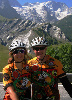
cabin and view from hill above
__________________
You could fall off a cliff and die.
You could get lost and die.
You could hit a tree and die.
OR YOU COULD STAY HOME AND FALL OFF THE COUCH AND DIE.
You could fall off a cliff and die.
You could get lost and die.
You could hit a tree and die.
OR YOU COULD STAY HOME AND FALL OFF THE COUCH AND DIE.
08-23-17, 04:22 PM
#17
pan y agua
Thread Starter
Join Date: Aug 2005
Location: Jacksonville
Posts: 31,304
Bikes: Willier Zero 7; Merlin Extralight; Calfee Dragonfly tandem, Calfee Adventure tandem; Cervelo P2; Motebecane Ti Fly 29er; Motebecanne Phantom Cross; Schwinn Paramount Track bike
Mentioned: 17 Post(s)
Tagged: 0 Thread(s)
Quoted: 1447 Post(s)
Liked 728 Times
in
373 Posts
Day 2, the first 10 miles to get to the BRP was maybe the hardest 10 miles I've done in my life (including ventoux and Alp de huez).
First four that google maps put me on turned to double track Jeep trail. It would take a very capable 4wd to get over that trail in a car. Doing it on a road bike with loaded panniers and 25mm tires was tough. But I saw neat Christmas tree farms, and a great view off a granite escarpment.
Next was the climb up NC215 which is steeper than anything on the Parkway. The 10 miles to the Parkway took me longer, than the remaining 36 miles on the BRP into Asheville.
https://www.strava.com/activities/1146881597
Last edited by merlinextraligh; 08-24-17 at 05:23 AM.
08-23-17, 04:40 PM
#18
pan y agua
Thread Starter
Join Date: Aug 2005
Location: Jacksonville
Posts: 31,304
Bikes: Willier Zero 7; Merlin Extralight; Calfee Dragonfly tandem, Calfee Adventure tandem; Cervelo P2; Motebecane Ti Fly 29er; Motebecanne Phantom Cross; Schwinn Paramount Track bike
Mentioned: 17 Post(s)
Tagged: 0 Thread(s)
Quoted: 1447 Post(s)
Liked 728 Times
in
373 Posts
Was going to stop at Mt Pisgah Inn for lunch. Awesome view and pretty good food right at Mt Pisgah around MP 408.
Unfortunately, the weight was too long so I just got snacks and water at the Country Store there.
My Pisgah Inn is a popular place to stay and the rooms all have great views, but a bit spartan accomodations.
Imho, Mt Pisgah's proximity to Asheville makes it an awkward lodging stop. Coming North once your to Mt Pisgah, you've got a fast 20 mile downhill to AVL, and I definitely recommend staying any of a number of places in AVL over Mt Pisgah Inn. So lunch at Mt Pisgah; stay in Asheville.
Last edited by merlinextraligh; 08-24-17 at 05:39 AM.
08-23-17, 04:47 PM
#19
pan y agua
Thread Starter
Join Date: Aug 2005
Location: Jacksonville
Posts: 31,304
Bikes: Willier Zero 7; Merlin Extralight; Calfee Dragonfly tandem, Calfee Adventure tandem; Cervelo P2; Motebecane Ti Fly 29er; Motebecanne Phantom Cross; Schwinn Paramount Track bike
Mentioned: 17 Post(s)
Tagged: 0 Thread(s)
Quoted: 1447 Post(s)
Liked 728 Times
in
373 Posts
A word about food and water. I pretty much have lodging, breakfast and dinner figured out. Lunch and fluids during the ride are a bit more problematic.
Today'a ride AVL to Little Switzerland, 55 miles 6700 vertical, there is no food on the Parkway in that stretch, and only water is the Visitors Center at the top of the climb out of AVL. I had just enough with 2 bottles. Hotter weather, I'd carry 3 bottles.
Lunch so far has been mostly Cliff bars. I would carry enough calories in bars, gels, energy drinks etc to get through each day, without assuming you're going to find it on the way.
08-23-17, 07:01 PM
#20
- Soli Deo Gloria -
Join Date: Aug 2015
Location: Northwest Georgia
Posts: 14,779
Bikes: 2018 Rodriguez Custom Fixed Gear, 2017 Niner RLT 9 RDO, 2015 Bianchi Pista, 2002 Fuji Robaix
Mentioned: 235 Post(s)
Tagged: 0 Thread(s)
Quoted: 6844 Post(s)
Liked 736 Times
in
469 Posts
It is easy to underestimate the rugged terrain of North Georgia, Western North Carolina and East Tennessee.
Might also be a bit late but I recommend filtering water even at a visitor's center or ranger station.
Would love to see more of the Strava routes when time permits.
-Tim-
Might also be a bit late but I recommend filtering water even at a visitor's center or ranger station.
Would love to see more of the Strava routes when time permits.
-Tim-
08-24-17, 05:44 AM
#21
pan y agua
Thread Starter
Join Date: Aug 2005
Location: Jacksonville
Posts: 31,304
Bikes: Willier Zero 7; Merlin Extralight; Calfee Dragonfly tandem, Calfee Adventure tandem; Cervelo P2; Motebecane Ti Fly 29er; Motebecanne Phantom Cross; Schwinn Paramount Track bike
Mentioned: 17 Post(s)
Tagged: 0 Thread(s)
Quoted: 1447 Post(s)
Liked 728 Times
in
373 Posts
Day 3 Asheville to Switzerland.
23 mile climb out of AVL is hard, not steep but so persistent it wears on you. AVL is at 2100 feet, you top out north of the Visitor's center at 5600 feet. The section between the Visitor center and Mt. Mitchell was very foggy. Otherwise a beautiful sunny day.
The Switzerland Inn is fantastic. Right on the Parkway, Lovely view, big rooms, good restaurant, bar, pool, fire pit.
https://www.strava.com/activities/1148972261
__________________
You could fall off a cliff and die.
You could get lost and die.
You could hit a tree and die.
OR YOU COULD STAY HOME AND FALL OFF THE COUCH AND DIE.
You could fall off a cliff and die.
You could get lost and die.
You could hit a tree and die.
OR YOU COULD STAY HOME AND FALL OFF THE COUCH AND DIE.
Last edited by merlinextraligh; 08-28-17 at 02:23 PM.
08-24-17, 07:54 PM
#22
Senior Member
Join Date: Mar 2011
Posts: 3,150
Bikes: 2013 Surly Disc Trucker, 2004 Novara Randonee , old fixie , etc
Mentioned: 3 Post(s)
Tagged: 0 Thread(s)
Quoted: 671 Post(s)
Likes: 0
Liked 49 Times
in
43 Posts
Day 2, the first 10 miles to get to the BRP was maybe the hardest 10 miles I've done in my life (including ventoux and Alp de huez).
First four that google maps put me on turned to double track Jeep trail. It would take a very capable 4wd to get over that trail in a car. Doing it on a road bike with loaded panniers and 25mm tires was tough. But I saw neat Christmas tree farms, and a great view off a granite escarpment.
Next was the climb up NC215 which is steeper than anything on the Parkway. The 10 miles to the Parkway took me longer, than the remaining 36 miles on the BRP into Asheville.
https://www.strava.com/activities/1146881597
First four that google maps put me on turned to double track Jeep trail. It would take a very capable 4wd to get over that trail in a car. Doing it on a road bike with loaded panniers and 25mm tires was tough. But I saw neat Christmas tree farms, and a great view off a granite escarpment.
Next was the climb up NC215 which is steeper than anything on the Parkway. The 10 miles to the Parkway took me longer, than the remaining 36 miles on the BRP into Asheville.
https://www.strava.com/activities/1146881597
 08-25-17, 04:58 AM
#24
pan y agua
Thread Starter
Join Date: Aug 2005
Location: Jacksonville
Posts: 31,304
Bikes: Willier Zero 7; Merlin Extralight; Calfee Dragonfly tandem, Calfee Adventure tandem; Cervelo P2; Motebecane Ti Fly 29er; Motebecanne Phantom Cross; Schwinn Paramount Track bike
Mentioned: 17 Post(s)
Tagged: 0 Thread(s)
Quoted: 1447 Post(s)
Liked 728 Times
in
373 Posts
yeah, I don't know why that happened, and haven't had the time or energy to fix them. Monday's a rest day. I'll fix those and post some more.
__________________
You could fall off a cliff and die.
You could get lost and die.
You could hit a tree and die.
OR YOU COULD STAY HOME AND FALL OFF THE COUCH AND DIE.
You could fall off a cliff and die.
You could get lost and die.
You could hit a tree and die.
OR YOU COULD STAY HOME AND FALL OFF THE COUCH AND DIE.
08-25-17, 05:07 AM
#25
pan y agua
Thread Starter
Join Date: Aug 2005
Location: Jacksonville
Posts: 31,304
Bikes: Willier Zero 7; Merlin Extralight; Calfee Dragonfly tandem, Calfee Adventure tandem; Cervelo P2; Motebecane Ti Fly 29er; Motebecanne Phantom Cross; Schwinn Paramount Track bike
Mentioned: 17 Post(s)
Tagged: 0 Thread(s)
Quoted: 1447 Post(s)
Liked 728 Times
in
373 Posts
Day 4 Switzerland to the Park Vista Motel (MP268, right off the Parkway near West Jefferson NC).
Smaller climbs on this section, but still added to 6700 vertical.
Several places worth stopping: Linville Falls (although that adds 3 miles out and back, Lin Cove Viaduct Visitor Center (if you've ever seen a pic of the Parkway it likely was Lin Cove, bottled water, and snacks are available here), Moses Cone state park.
The Park Vista Motel is a funky place. It was closed and only recently renovated and reopened. You pull up and you think you're checking into the Bates Motel. Only one of the two bulidings has been renovated. But inside the rooms have been nicely renovated and comfortable with everything you need. The people are very nice, and they have a very nice restaurant, that attracts lots of locals.
The Park Vista Motel, also is at a point where the Mountain to Sea Trail crosses the BRP, so hikers as well as cyclists stay here, and the Motel is supportive of both.
https://www.strava.com/activities/1150684825
__________________
You could fall off a cliff and die.
You could get lost and die.
You could hit a tree and die.
OR YOU COULD STAY HOME AND FALL OFF THE COUCH AND DIE.
You could fall off a cliff and die.
You could get lost and die.
You could hit a tree and die.
OR YOU COULD STAY HOME AND FALL OFF THE COUCH AND DIE.