


Safety map
 09-05-19, 11:56 AM
#1
Senior Member
Thread Starter

Safety map
Dont know why I never noticed this map beforeˇ
https://travelmaps.state.gov/TSGMap/...6,12.490597364
https://travelmaps.state.gov/TSGMap/...6,12.490597364
 09-05-19, 12:09 PM
#2
bicycle tourist
I read the US travel advisories and take into account the 1-4 ratings. Seems like this map is mostly those ratings on a country-by-country basis - except for Mexico.
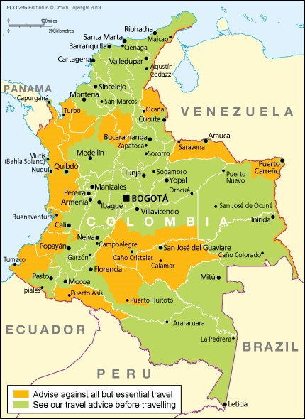
I also like the UK Foreign Service travel maps as a contrast since they sometimes show additional details for parts of a country. For example, following is the current map for Colombia:
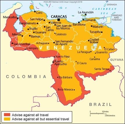
or Venezuela
I also like to calibrate these things a bit. For example, here is how the UK describes "safety and security" in the USA. I find it interesting to see the Orlando airport called out...
https://www.gov.uk/foreign-travel-ad...y-and-security
I also like the UK Foreign Service travel maps as a contrast since they sometimes show additional details for parts of a country. For example, following is the current map for Colombia:
or Venezuela
I also like to calibrate these things a bit. For example, here is how the UK describes "safety and security" in the USA. I find it interesting to see the Orlando airport called out...
https://www.gov.uk/foreign-travel-ad...y-and-security
09-05-19, 12:22 PM
#3
Senior Member
Join Date: Jan 2010
Posts: 39,317
Mentioned: 211 Post(s)
Tagged: 1 Thread(s)
Quoted: 18445 Post(s)
Liked 15,671 Times
in
7,367 Posts
I've heard Denmark is scary scary. ")
Look what I just noticed on my desk.

Look what I just noticed on my desk.
Last edited by indyfabz; 09-05-19 at 12:27 PM.
09-06-19, 07:31 AM
#4
Full Member
Join Date: Sep 2005
Location: Tulsa, OK
Posts: 451
Bikes: Co-Motion Americano Pinion P18; Co-Motion Americano Rohloff; Thorn Nomad MkII, Robert Beckman Skakkit (FOR SALE), Santana Tandem, ICE Adventure FS
Mentioned: 1 Post(s)
Tagged: 0 Thread(s)
Quoted: 169 Post(s)
Liked 64 Times
in
48 Posts
I especially agree that when touring in Antarctica we should "exercise increased caution". This reminds me of how when traveling (regardless of where in the world), people always warn you about to be careful of neighboring states, regions, countries, etc. but there area is fine.
Obviously, you should use caution regardless of where you travel and try to reasonably mitigate getting into danger, i.e. don't talk politics, religion, whiskey, helmets, or other controversial topics.
Tailwinds, John
Obviously, you should use caution regardless of where you travel and try to reasonably mitigate getting into danger, i.e. don't talk politics, religion, whiskey, helmets, or other controversial topics.
Tailwinds, John

 09-06-19, 09:18 AM
#6
bicycle tourist
However, I do think the map makes it a bit easier to see what looks like occasional inconsistencies in travel warning levels. For example
- Is Spain more dangerous than Portugal
- Is Luxembourg safer than all the countries surrounding it?
- Is Uzbekistan really safer than Denmark?
In general, I will look at a map like this - but even more importantly also read the warnings. So for example, if I open up the information for Denmark, I notice a recent travel advisory (September 2nd) that suggests a protest march of up to 3000 people may protest around the US embassy. OK, fine enough, but now that I know the specifics, but if the date isn't September 2nd or if I am not in that part of Copenhagen, then this is easy enough to avoid - so I won't let this particular travel warning level influence my plans. Even in places with more elevated levels, I still find it useful to read what is behind the warnings; and also read from more than one source (e.g. also UK foreign ministry or Australian or Canadian) to see if there is similar information.
09-22-19, 07:08 PM
#9
Senior Member
Thread Starter
Venezuela is a lot like pre WWII Germany at the moment.
A well educated person could make a better choice for travel plans than a beer guy on the web at 4am
I read the US travel advisories and take into account the 1-4 ratings. Seems like this map is mostly those ratings on a country-by-country basis - except for Mexico.
I also like the UK Foreign Service travel maps as a contrast since they sometimes show additional details for parts of a country. For example, following is the current map for Colombia:
or Venezuela
I also like to calibrate these things a bit. For example, here is how the UK describes "safety and security" in the USA. I find it interesting to see the Orlando airport called out...
https://www.gov.uk/foreign-travel-ad...y-and-security
Ever been to Gorda California?
https://www.gov.uk/foreign-travel-advice/venezuela
The Foreign and Commonwealth Office (FCO) advise against all travel to within 80 km (50 miles) of the Colombian border and 40 km (25 miles) of the Brazilian border. Drug traffickers and illegal armed groups are active along the border area with Colombia and Brazil and there is a risk of kidnapping.
I am so very close to that red line at this minute.
str, do you think I should look at a safety map? I saw a floating cocaine labatory 3 days ago, should I be concerned<? My boat off loaded about 100 or moe 100 kilo bags of coca leaves to the factory boat, and the workes bought most every bag of cookies form the kitchen on my transport boat.
Last edited by chrisx; 09-22-19 at 07:30 PM.
