


Cheap navigation
 06-23-21, 09:03 AM
#26
Senior Member
Join Date: May 2014
Posts: 2,537
Bikes: yes
Mentioned: 18 Post(s)
Tagged: 0 Thread(s)
Quoted: 1281 Post(s)
Liked 643 Times
in
329 Posts
If a person wants to get a GPS, they should get a good one. That starts around a Garmin 830 or similar units from other manufacturers, IMHO. Unless you know better what you want, go ahead and get a unit with visible maps, navigation, and connnectivity and smarts for whatever sensors you might want now or in the future (HRM, power meter, etc.). Buying less is like buying a cheap guitar or a cheap bike; if you think you really might like it, the price of the first one is wasted, and it's more likely to make you not want to play, ride, or navigate because the experience of the cheap thing is so bad.
I'm not going to turn this into Wahoo vs. Garmin but I'll just say I've been absolutely satisfied with my Wahoo. It just works and has all the connectivity and customizable data fields I could ever want. It even plays well with my Garmin Varia, which is nice.
The map is pretty minimalist though. I guess I don't rely super heavily on the map -- I just kind of use it to have a general idea of where I'm going, but for more detailed nav then yes, you'd probably want one of the bigger Garmins or the Element Roam.
 06-23-21, 09:32 AM
#27

Senior Member

Join Date: May 2010
Location: Bastrop Texas
Posts: 4,483
Bikes: Univega, Peu P6, Peu PR-10, Ted Williams, Peu UO-8, Peu UO-18 Mixte, Peu Dolomites
Mentioned: 13 Post(s)
Tagged: 0 Thread(s)
Quoted: 968 Post(s)
Liked 1,631 Times
in
1,047 Posts
I agree. Everyone must be familiar with the 2D navigation system. It is tried and true. Using a GPS to follow a path on a map or vice versa is fun. It gives you some time to stop, take a breath, and ground yourself...
And Yes, I love Orienteering. And yes, I do have a Slide Rule and remember how to use Log tables... Ha
And Yes, I love Orienteering. And yes, I do have a Slide Rule and remember how to use Log tables... Ha
__________________
 No matter where you're at... There you are... Δf:=f(1/2)-f(-1/2)
No matter where you're at... There you are... Δf:=f(1/2)-f(-1/2)
06-23-21, 10:22 AM
#28
Senior Member
Join Date: Aug 2010
Location: Madison, WI
Posts: 11,212
Bikes: 1961 Ideor, 1966 Perfekt 3 Speed AB Hub, 1994 Bridgestone MB-6, 2006 Airnimal Joey, 2009 Thorn Sherpa, 2013 Thorn Nomad MkII, 2015 VO Pass Hunter, 2017 Lynskey Backroad, 2017 Raleigh Gran Prix, 1980s Bianchi Mixte on a trainer. Others are now gone.
Mentioned: 48 Post(s)
Tagged: 0 Thread(s)
Quoted: 3462 Post(s)
Liked 1,468 Times
in
1,145 Posts
On the topic of paper maps, in my previous post I had a photo of my GPS but also had the road map in the handlebar bag pocket. I am retired but in my previous working life, I worked with maps every day of my professional career and I consider a map a must have item on a bike tour. But, I have seen people that could not figure out how to read a map at all, handing a map to them is no help. Some people have the spatial aptitude for working with maps, some do not.
Compass, on a bike tour I always have one, but maybe only glance at it once or twice a week. But there are times it is quite valuable. On a day where I can see where the sun is, I will know roughly which direction is which, it is second nature to me. But on a day with heavy overcast where you can't see where the sun is, if i is an area of curvy roads, I find it really easy to get lost. Thus, a compass can come in really handy if you are not using a GPS. That said, if my GPS is turned on, the only times I have needed a compass was when I was on a narrow street and the nearby buildings blocked enough satellite signals that my GPS lost its location, which has happened to me several times.
Yup, but at least this time we did not get the long list of must-haves that often get cited after a lot of good suggestions are made. I was waiting for the - but that does not have voice that tells me how far to the next turn, that can't communicate to my phone to this specific website that gives me the menu at the restaurant up ahead, etc.
Compass, on a bike tour I always have one, but maybe only glance at it once or twice a week. But there are times it is quite valuable. On a day where I can see where the sun is, I will know roughly which direction is which, it is second nature to me. But on a day with heavy overcast where you can't see where the sun is, if i is an area of curvy roads, I find it really easy to get lost. Thus, a compass can come in really handy if you are not using a GPS. That said, if my GPS is turned on, the only times I have needed a compass was when I was on a narrow street and the nearby buildings blocked enough satellite signals that my GPS lost its location, which has happened to me several times.
There's a fairly predictable drift line to threads like these. They start with "I want to navigate for cheap," go through "I've got a problem with my phone" to "I want a GPS but don't want to pay for a [fill-in-the-blank]" and end up with "I want something that combines the best features of a GPS and cell/google maps."
....
....
06-23-21, 11:03 AM
#29
Senior Member
Join Date: Jan 2010
Posts: 39,254
Mentioned: 211 Post(s)
Tagged: 1 Thread(s)
Quoted: 18424 Post(s)
Liked 15,579 Times
in
7,337 Posts
https://www.benscycle.com/cue-clip-m...xoCE18QAvD_BwE
Likes For indyfabz:
06-23-21, 11:06 AM
#30
mosquito rancher

I rode the Southern Tier eleven years ago using the ACA's printed maps (which are great), but when I'm exploring new territory these days, I use electronic maps. I'd never discourage using printed maps, especially as a backup, but I think the choice between electronic and printed maps these days comes down to a philosophical or aesthetic decision. With printed maps, I spent a lot more time fussing with my maps, trying to figure out where I was, and missing turns than I do with electronic ones, but—if the choice is between a big foldout map and a 4" screen—it's much easier to understand the route overall with paper maps, especially if they include elevation profiles.
__________________
Adam Rice
Adam Rice
Likes For adamrice:
06-23-21, 01:21 PM
#31
Senior Member
ksryder said a few posts back: "Maybe I'm zoned out and I missed a road sign."
I deal with THAT possibility by making up a song about the next cue ("Left on East Street, Right on Main, Then at the light, Make a left agaaain") and repeat it in my head until I get to the point where I have to turn. Then I make up a new song for the next cue. Am I a nutjob, or what?
I deal with THAT possibility by making up a song about the next cue ("Left on East Street, Right on Main, Then at the light, Make a left agaaain") and repeat it in my head until I get to the point where I have to turn. Then I make up a new song for the next cue. Am I a nutjob, or what?
06-23-21, 02:18 PM
#32
Senior Member
depends on the situation.
here on the island, we have the main outer loop highway, with an assortment of provincial roads linking the towns.
aside from that we have a maze of farm and county roads throughout the interior, mostly with no signage. only 'bout half the population can speak recognizable chinese, so good luck asking for directions.
interior roads are not straight, looping around hills and valleys and volcanic flows. highly vegetated, not always clear views from under the palm and banana trees.
cheap handlebar mount compass is my favorite tool for riding in this area. also came in mucho handy taking the unmarked dirt trails through laos and cambodia.
as to the maps and cue sheets..........i usually daily cue sheets and keep the maps sealed in the saddlebags, but also drawbacks if the maps haven't been updated. or you're in a country where all the squiggles on the roadsigns look the same. yes, i'm talkin' bout you, myanmar! or here in parts of china where the maps are in standard chinese, but the signs are in the local dialect.
I used to sail and hiked before gps existed so I have learned to use use a map, topo, naitical chart, and compass, but in my daily life and on tour I get round using my cell phone these days.
06-23-21, 04:26 PM
#33
Senior Member
Join Date: Jul 2008
Location: 25 miles northwest of Boston
Posts: 29,552
Bikes: Bottecchia Sprint, GT Timberline 29r, Marin Muirwoods 29er, Trek FX Alpha 7.0
Mentioned: 112 Post(s)
Tagged: 0 Thread(s)
Quoted: 5224 Post(s)
Liked 3,585 Times
in
2,344 Posts
I use something like this, which I got for free at my club’s banquet.
https://www.benscycle.com/cue-clip-m...xoCE18QAvD_BwE
https://www.benscycle.com/cue-clip-m...xoCE18QAvD_BwE

maps let one see the big picture
& nearby details that might come in handy
Last edited by rumrunn6; 06-23-21 at 04:44 PM.
06-23-21, 04:46 PM
#34
Senior Member
Join Date: Jul 2008
Location: 25 miles northwest of Boston
Posts: 29,552
Bikes: Bottecchia Sprint, GT Timberline 29r, Marin Muirwoods 29er, Trek FX Alpha 7.0
Mentioned: 112 Post(s)
Tagged: 0 Thread(s)
Quoted: 5224 Post(s)
Liked 3,585 Times
in
2,344 Posts
06-23-21, 08:06 PM
#35
Senior Member
Dirtydozen, re your market in Europe, I'm sure what is available is different than in my country, so I guess you're going to have to just visit many stores and compare prices and options--and then ask opinions on those specific models.
Here in Canada, even though I don't pay too much attention to GPS units (especially during covid with such reduced access to stores) I certainly have noticed that prices are certainly a lot more than 100 euros.
Here in Canada, even though I don't pay too much attention to GPS units (especially during covid with such reduced access to stores) I certainly have noticed that prices are certainly a lot more than 100 euros.
06-24-21, 06:39 AM
#36
Senior Member
Yeah I find most people can't give good directions to save their life.
I don't know if it was because I was in an artillery unit, where accurate map reading was *kinda* important, or if it's just because I've always had thing for maps, but I'd rather have someone give me the address so I can look it up and figure out the best route. Old people give needlessly complicated and inaccurate directions like "turn left at the red barn and then it'll be the third white house past old Lady Johnson's cow--but the cow died in 1999" and young people don't understand things like "north" and "east" and "go three miles."
Back to the thread though -- I was a little stubborn about using maps and cue sheets for a long time, my reasoning being that cue sheets don't run out of batteries. But in practice there's a lot of things that can wrong, admittedly mostly because of human error. Maybe I'm zoned out and I missed a road sign. Maybe the name of the road sign is one thing on the cue sheet but we're actually in a different county and they named it something different. Maybe the county hasn't maintained the signs and it's missing. Maybe I misread the cue sheet and I'm looking for the next cue. Maybe I screwed up the mileage somehow and now I'm off. I mean, I can get back on track but it's an avoidable hassle.
A few years ago I bought a GPS computer with navigation (wahoo bolt) mainly to more accurately log my mileage and keep track of heart rate, but because it came with navigation I might as well give it a shot. After using it in a long gravel race I was an instant convert, you really can't beat the ease and convenience. I'll still carry maps and cue sheets as a backup but it's a definite quality of life upgrade.
From early on decades ago, I learned early on from getting burnt asking locals for directions, to ask one person, judge their body language etc ie not sure, clueless looking etc, then ask another person and compare. If same answer, probably a good sign. If not, ask a third.
My early trips also included this being in French, not my mother tongue, so an added factor too, people talking fast, weird accent I wasn't used to, France vs Quebec accent.
Likes For djb:
06-24-21, 07:47 AM
#37
Senior Member
Join Date: May 2014
Posts: 2,537
Bikes: yes
Mentioned: 18 Post(s)
Tagged: 0 Thread(s)
Quoted: 1281 Post(s)
Liked 643 Times
in
329 Posts
Just wanted to say how much of a chuckle that gave me. Holy geez it's true.
From early on decades ago, I learned early on from getting burnt asking locals for directions, to ask one person, judge their body language etc ie not sure, clueless looking etc, then ask another person and compare. If same answer, probably a good sign. If not, ask a third.
My early trips also included this being in French, not my mother tongue, so an added factor too, people talking fast, weird accent I wasn't used to, France vs Quebec accent.
Then they roll down the window and ask for directions because I'm on a bike and I guess it's easier then trying to ask a fellow motorist who can't hear them. I may or may not give them directions to the county jail.
06-24-21, 08:04 PM
#38
Senior Member
Oh yeah, I'm certain I've been victim of this from asshats who get a chuckle screwing up someone's day. Hard to tell if they are just compete fricking idiots or like screwing around.
Kinda like the psychopathic truck driver who breezes just past your shoulder when there isn't another vehicle in sight....
Kinda like the psychopathic truck driver who breezes just past your shoulder when there isn't another vehicle in sight....
06-25-21, 04:55 AM
#39
Senior Member
Join Date: Aug 2010
Location: Madison, WI
Posts: 11,212
Bikes: 1961 Ideor, 1966 Perfekt 3 Speed AB Hub, 1994 Bridgestone MB-6, 2006 Airnimal Joey, 2009 Thorn Sherpa, 2013 Thorn Nomad MkII, 2015 VO Pass Hunter, 2017 Lynskey Backroad, 2017 Raleigh Gran Prix, 1980s Bianchi Mixte on a trainer. Others are now gone.
Mentioned: 48 Post(s)
Tagged: 0 Thread(s)
Quoted: 3462 Post(s)
Liked 1,468 Times
in
1,145 Posts
Oh yeah, I'm certain I've been victim of this from asshats who get a chuckle screwing up someone's day. Hard to tell if they are just compete fricking idiots or like screwing around.
Kinda like the psychopathic truck driver who breezes just past your shoulder when there isn't another vehicle in sight....
Kinda like the psychopathic truck driver who breezes just past your shoulder when there isn't another vehicle in sight....
Unfortunately, in my working career at one time I had a boss like that.
06-25-21, 08:53 AM
#40
Senior Member
Heh! Reminds me of an experience in Montreal. After a 6 week trip in France I flew back to Montreal. After crossing the Cartier Bridge while cycling back to NH I confidently stopped a pedestrian and asked with my broken, phrase book French ... "Excusez-moi monsieur, je cherche la route de Chambly?" He waved me on like he didn't understand a word!
06-25-21, 10:16 AM
#41
Senior Member
Join Date: Sep 2007
Location: Far beyond the pale horizon.
Posts: 14,278
Mentioned: 31 Post(s)
Tagged: 0 Thread(s)
Quoted: 4260 Post(s)
Liked 1,364 Times
in
945 Posts
I love to travel by bike, but navigation can be quite a pain sometimes, i would like to buy a device that would help me with navigation.
I'm looking for the least expensive options, and i'm not necessary looking for a GPS bike computer, could be a watch or maybe something else.
I'm looking for the least expensive options, and i'm not necessary looking for a GPS bike computer, could be a watch or maybe something else.
06-25-21, 10:22 AM
#42
Senior Member
Join Date: Sep 2007
Location: Far beyond the pale horizon.
Posts: 14,278
Mentioned: 31 Post(s)
Tagged: 0 Thread(s)
Quoted: 4260 Post(s)
Liked 1,364 Times
in
945 Posts
A phone is a useful addition to a dedicated GPS device.
You probably don't want to rely on Google maps either since it (basically) relies on having a network connection. You can get apps that let you download maps before-hand (using WiFi). These also usually let you load tracks. Doing that would make it easier to check to see whether you were going the right way.
These sorts of things can still happen using a GPS device.
06-25-21, 10:31 AM
#43
Senior Member
Join Date: Sep 2007
Location: Far beyond the pale horizon.
Posts: 14,278
Mentioned: 31 Post(s)
Tagged: 0 Thread(s)
Quoted: 4260 Post(s)
Liked 1,364 Times
in
945 Posts
This used to be my favorite source (routable bicycle layer) but they have reduced the amount of map size you can obtain a few months ago.
Free worldwide Garmin maps from OpenStreetMap
Free worldwide Garmin maps from OpenStreetMap
One big advantage of that site was the ability to download just the region you needed.
An alternative is https://extract.bbbike.org/ This also lets you download custom regions. It's a little bit tricky to use at first.
Last edited by njkayaker; 06-25-21 at 10:41 AM.
06-25-21, 10:46 AM
#44
Senior Member
Join Date: Sep 2007
Location: Far beyond the pale horizon.
Posts: 14,278
Mentioned: 31 Post(s)
Tagged: 0 Thread(s)
Quoted: 4260 Post(s)
Liked 1,364 Times
in
945 Posts
If you are using your phone anyway, why not use maps installed on the phone? The maps on the phone also avoid issues of needing to keep purchasing updated paper maps.
One big advantage of digital maps is that they work at all zoom levels.
Paper maps that are large scale don't have enough detail and low scale maps don't cover a large region.
Likes For njkayaker:
06-25-21, 11:15 AM
#45
Senior Member
Join Date: Sep 2007
Location: Far beyond the pale horizon.
Posts: 14,278
Mentioned: 31 Post(s)
Tagged: 0 Thread(s)
Quoted: 4260 Post(s)
Liked 1,364 Times
in
945 Posts
FWIW, here's my take:
1. You can't beat paper maps and cue sheets for price, nor for functionality in remote places.
2. GPS are better than cell phones for battery life, water (sweat and rain) resistance, mounts, and working out of range of cell towers. There are some workarounds available for phones.
3. Phones are better that GPS, if you've got service, for navigating to an address and real time re-routing, though the quality of the re-route may be suspect.
4. With cache batteries, you can extend GPS runtimes to several days' riding; I don't know how long you can extend a cell runtime.
- Downloadable maps for phones are cheap or free and get updated regularly. They work at various zoom levels and occupy much less space.
- With a little bit of care, one doesn't need service for routing on phones. There are quite a few apps that do this.
- Given that service is spotty, I'd rate it as some sort of "doing it wrong" if one relies on something that requires service.
- The rerouting of using anything (the internet, on-device routing, and even paper maps) may "be suspect".
- One doesn't have to use the phone in a way that requires keeping it running all the time.
- Dedicated GPS units have their advantages but "everybody" already has a smartphone. It might make some sense to investigate using that first (the phone is also a useful addition to a dedicated GPS).
- An $8 plastic pouch solves the water resistance issue.
06-25-21, 11:16 AM
#46
Senior Member

Join Date: Apr 2011
Posts: 782
Mentioned: 1 Post(s)
Tagged: 0 Thread(s)
Quoted: 226 Post(s)
Liked 45 Times
in
32 Posts
I'm recalling that Google maps worked just fine when I turned off my network connection. The GPS functions is apparently still there and would show me on the map where I was located. I'm in the Midwest so I didn't really have to rely on turn-by-turn directions out in the Hinterlands but I do recall being pleasantly surprised that it showed me my location while disconnected from the Network. As long as you upload the map when connected to the network and leave it uploaded when you disconnect from the network it worked just fine.
06-25-21, 11:25 AM
#48
Senior Member
Join Date: Sep 2007
Location: Far beyond the pale horizon.
Posts: 14,278
Mentioned: 31 Post(s)
Tagged: 0 Thread(s)
Quoted: 4260 Post(s)
Liked 1,364 Times
in
945 Posts
I'm recalling that Google maps worked just fine when I turned off my network connection. The GPS functions is apparently still there and would show me on the map where I was located. I'm in the Midwest so I didn't really have to rely on turn-by-turn directions out in the Hinterlands but I do recall being pleasantly surprised that it showed me my location while disconnected from the Network. As long as you upload the map when connected to the network and leave it uploaded when you disconnect from the network it worked just fine.
Google maps caches data (stores some stuff locally and temporarily). So, it isn't surprising it worked. Still. there's a limit to how well it will work (it won't be able to calculate a route without service).
I think people using their phones for navigation should (also) use an app that doesn't rely on service at all. That way, they won't ever be stuck with something that happens not to work without service.
These alternatives are cheap and are useful as backups (if you prefer Google maps). And you can often load tracks and waypoints onto them.
I've used phones for navigation/maps in countries that I don't have service in.
Last edited by njkayaker; 06-25-21 at 01:30 PM.
06-25-21, 01:53 PM
#49
Senior Member
Join Date: Jul 2008
Location: 25 miles northwest of Boston
Posts: 29,552
Bikes: Bottecchia Sprint, GT Timberline 29r, Marin Muirwoods 29er, Trek FX Alpha 7.0
Mentioned: 112 Post(s)
Tagged: 0 Thread(s)
Quoted: 5224 Post(s)
Liked 3,585 Times
in
2,344 Posts
I have no compelling reason
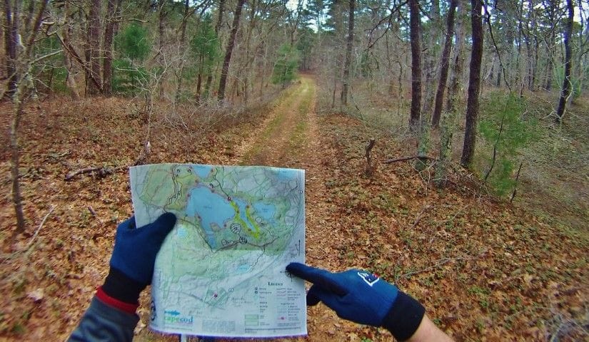
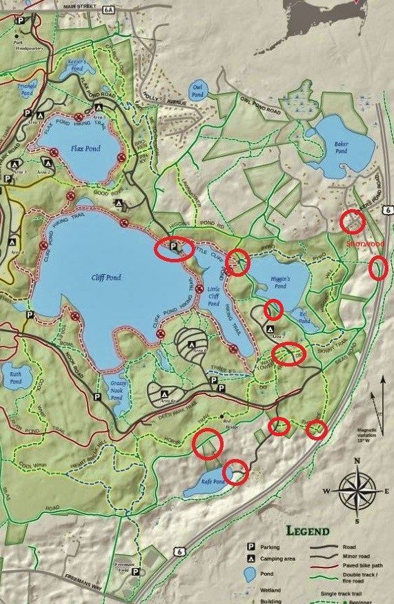
fwiw I like making notes on paper maps, especially for return trips to the same place. as I locate myself at an intersection I can make a circle. I can draw arrows indicating my direction. if I get disoriented I can back track. afterwards I can review my ride. the next time I go back, with that same map, I can see where I've been & make decisions about where to go today. it's good to have a phone w/ a full charge in case something happens, like an injury or mechanical failure & if I have to stay overnight waiting for rescue. if I use my phone all day long I won't have a full charge

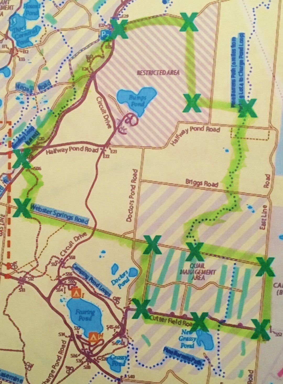
I can also print new copies of the same map & make clean notes. I don't have it handy but I have this one on my work computer. I have another copy at home with notes & highlights showing 3 rides in the same area. I can then go back a year later w/o remembering anything but know that using the map, I can do a new different ride
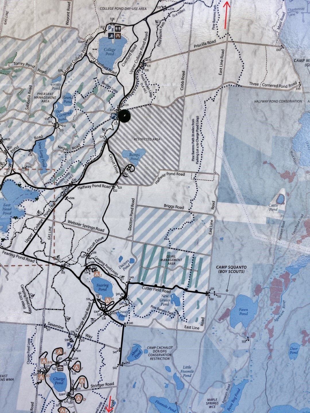
I enjoy looking at maps, both on my computer & also paper maps on the couch & sometimes feel bad for ppl on the side of the road in bright sunlight squinting at their tiny phone screens. I also don't have to worry about cell service w/ a paper map
but I fully support anyone for using their personal navigation choice
fwiw I like making notes on paper maps, especially for return trips to the same place. as I locate myself at an intersection I can make a circle. I can draw arrows indicating my direction. if I get disoriented I can back track. afterwards I can review my ride. the next time I go back, with that same map, I can see where I've been & make decisions about where to go today. it's good to have a phone w/ a full charge in case something happens, like an injury or mechanical failure & if I have to stay overnight waiting for rescue. if I use my phone all day long I won't have a full charge
I can also print new copies of the same map & make clean notes. I don't have it handy but I have this one on my work computer. I have another copy at home with notes & highlights showing 3 rides in the same area. I can then go back a year later w/o remembering anything but know that using the map, I can do a new different ride
I enjoy looking at maps, both on my computer & also paper maps on the couch & sometimes feel bad for ppl on the side of the road in bright sunlight squinting at their tiny phone screens. I also don't have to worry about cell service w/ a paper map
but I fully support anyone for using their personal navigation choice
Last edited by rumrunn6; 06-25-21 at 04:19 PM.
Likes For rumrunn6:
06-25-21, 03:06 PM
#50
Senior Member
hey rumrunner--important stuff first--so did you get your sorry keester thrown in the slammer for riding through the "restricted zone" ?
Enquiring minds want to know.
Enquiring minds want to know.
Likes For djb: