


Your "go-to" ride
 10-24-21, 10:10 AM
#51
hoppipola


But let me ask you, if i may, what are you referring to when you are saying everything?
 10-24-21, 10:48 AM
#52

Senior Member

Mine is a 7 mile loop around the area where I live. I treat it as a personal time trial each ride. It has two short fairly steep climbs that I attack and one long lesser climb that I try to maintain speed. I ride this course clockwise most of the time. When I feel my muscles have memorized the loop too much, I ride it counterclockwise. If I struggle too much I give it up for about a month and do another 10 mile loop instead.
10-24-21, 11:09 AM
#53
Full Member
Join Date: Sep 2017
Location: Maryland
Posts: 368
Bikes: Diamondback Haanjo Trail, Fuji Team Road
Liked 68 Times
in
46 Posts
I used to live in Claremont Mesa and while I didn't ride it all the time, one of my favorites was out and back to the Point Loma Lighthouse. I was there for a conference in Feb 2020 and rented a bike just to ride there again from downtown.
10-24-21, 12:17 PM
#54
Newbie
my mother in law lives in fort Sheridan and told me how annoying all the cyclists are who go around the fort. And then I told her I�m obsessed with cycling. We get along ok now
10-24-21, 01:58 PM
#55
Senior Member
Thread Starter
Join Date: Jul 2008
Location: 25 miles northwest of Boston
Posts: 29,653
Bikes: Bottecchia Sprint, GT Timberline 29r, Marin Muirwoods 29er, Trek FX Alpha 7.0
Liked 3,680 Times
in
2,381 Posts
10-24-21, 02:09 PM
#56
Senior Member
Join Date: Sep 2020
Location: SE Wyoming
Posts: 604
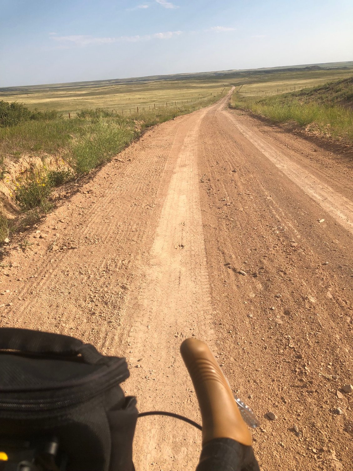
Bikes: 1995 Specialized Rockhopper,1989 Specialized Rock Combo, 2013 Specialized Tarmac Elite
Liked 589 Times
in
278 Posts
Indian Hill Road looking north into the Horse Creek drainage. A 42 mile loop from my house north of Cheyenne. Mostly gravel with some asphalt on the way home.
Likes For Inusuit:
10-24-21, 03:13 PM
#57
hoppipola
Likes For holytrousers:
10-25-21, 01:47 AM
#58
The Wheezing Geezer

Join Date: Oct 2021
Location: Espa�ola, NM
Posts: 1,264
Bikes: 1976 Fredo Speciale, Rivendell Clem Smith Jr., Libertas mixte
Liked 1,139 Times
in
542 Posts
Tres San Pedros
Upper San Pedro to Middle San Pedro to Lower San Pedro forms a four-mile loop about a mile from my house. They were re-paved this summer and went from very bumpy to smooth as silk. It's almost as if they did me a personal favor! 
Likes For Fredo76:
10-25-21, 02:55 AM
#59
Senior Member
Join Date: Jun 2013
Location: SW Fl.
Posts: 5,675
Bikes: Day6 Semi Recumbent "FIREBALL", 1981 Custom Touring Paramount, 1983 Road Paramount, 2013 Giant Propel Advanced SL3, 2018 Specialized Red Roubaix Expert mech., 2002 Magna 7sp hybrid, 1976 Bassett Racing 45sp Cruiser
Liked 888 Times
in
540 Posts
Thankfully I have no need to travel miles by car to begin an epic ride. Roll out my garage and no farther than 8.5 miles from my driveway can yield a good crank spinning work out. Starting around a (+/-) midnight time frame and under a full moon with music as company = a no traffic cosmic drift experience
https://www.strava.com/activities/4669579494
https://www.strava.com/activities/4669579494
10-25-21, 03:18 AM
#60
Senior Member

Likes For Lazyass:
10-25-21, 04:19 AM
#61
Senior Member
Thread Starter
Join Date: Jul 2008
Location: 25 miles northwest of Boston
Posts: 29,653
Bikes: Bottecchia Sprint, GT Timberline 29r, Marin Muirwoods 29er, Trek FX Alpha 7.0
Liked 3,680 Times
in
2,381 Posts
10-25-21, 11:21 AM
#62
Senior Member
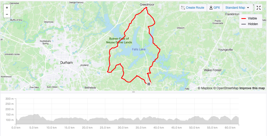
I have several go to routes that are about two hours in duration. Typical rides are on rural roads with rolling hills. Below ride is 62 km with about 500m of climbing.
10-25-21, 11:49 AM
#63
Newbie
Join Date: May 2021
Location: Auburn, California
Posts: 17
Bikes: Giant TCR Advanced SL3, Koba MTB, Zieleman Type Special criterium bike, Gitane Pro track bike
Likes: 0
Liked 2 Times
in
2 Posts
Lake Natomas loop
Around Sacramento it�s pretty flat until you get in the foothills. There�s a 12 mile paved, cycling and pedestrian only loop around Lake Natoma near Folsom. It has some gradual elevation changes and superb views of the lake, salmon hatchery and Sierras. It�s not very crowded during the week with lots of spots to stop for a breather if so needed. That�s my �go-to� ride.
Likes For StanJF:
10-25-21, 11:58 AM
#64
Senior Member
Join Date: Dec 2010
Location: northern Deep South
Posts: 9,156
Bikes: Fuji Touring, Novara Randonee
Liked 2,158 Times
in
1,328 Posts
Likes For pdlamb:
10-25-21, 12:00 PM
#65
Full Member
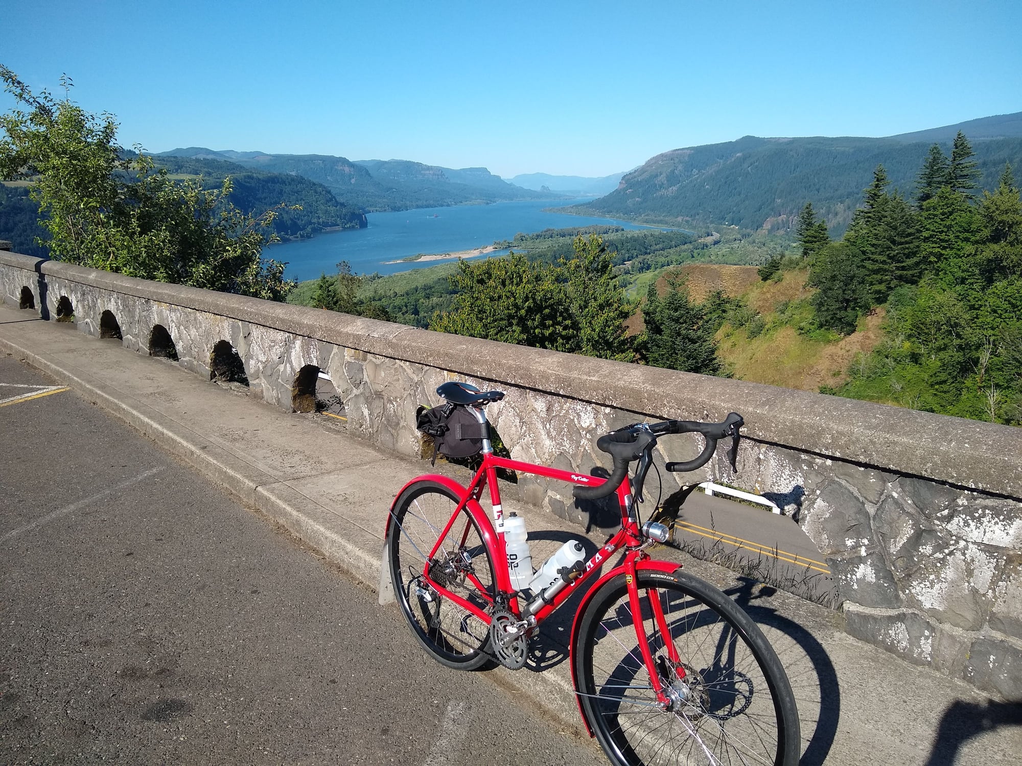
Columbia River Gorge Historic Highway, to Crown Point and back is the backbone of many rides. Options off the highway for more miles and climbing. Partial climb up Larch Mountain if even more time. Full Larch for a long grade. Making it a loop via Bull Run. Extend it to Cascade Locks for a full day ride.
decades ago. Was not into cycling at the time (married to the wrong woman  but drove the Columbia Gorge many times. Beautiful drive. So many waterfalls along the way. Can actually take it all the way to Boise, ID, if one has the time. Also can do a "u-turn" at Bridge of the Gods and return on the WA side of the Columbia. Hmmmm...maybe I'll put that on my bucket list for a near-future getaway trip....cheers....
10-25-21, 12:10 PM
but drove the Columbia Gorge many times. Beautiful drive. So many waterfalls along the way. Can actually take it all the way to Boise, ID, if one has the time. Also can do a "u-turn" at Bridge of the Gods and return on the WA side of the Columbia. Hmmmm...maybe I'll put that on my bucket list for a near-future getaway trip....cheers....
10-25-21, 12:10 PM
#66
Newbie racer
This is a "go to" route of about 2 hours for me that similar area:
https://www.strava.com/activities/6156322917
10-25-21, 12:12 PM
#67
Senior Member
Join Date: Sep 2020
Location: SE Wyoming
Posts: 604
Bikes: 1995 Specialized Rockhopper,1989 Specialized Rock Combo, 2013 Specialized Tarmac Elite
Liked 589 Times
in
278 Posts
My Specialized Rock Combo is my go to ride for this loop. Recently put some Schwalbe Land Cruiser tires on it, which seem ideal for gravel but still run quiet and smooth on pavement. I'm fortunate to have several great dirt road rides within a mile or two of my house.
10-25-21, 12:14 PM
#68
Senior Member
Join Date: Aug 2011
Location: Fort Wayne, IN
Posts: 464
Bikes: No. 22 Bicycle Great Divide, Lynskey R260, Salsa Colossal Ti, Litespeed T5, Lynskey Peloton, Bianchi Vigorelli, CAAD 10, Giant FastRoad CoMax 1, C-Dale Quick 1
Liked 36 Times
in
18 Posts
When my wife and I want a quick, convenient route, we have one pretty good option, a rectangular loop of 9.5 miles. It starts and ends right out our driveway, as we live about midway along one of the rectangle's long sides. This is the only part of the ride that's on a road. The other long side and both short ends are paved MUPs.
At one end of the rectangle, there is pretty scenery, especially at sunset. At the opposite end, there are lots trees and a pond. The long sides take us through residential neighborhoods and farm fields. There are no commercial, industrial, or urban areas.
The route sits on a slight incline, not steep, but just enough slope to make it interesting. We can choose how we want to take the incline by riding the loop clockwise or counter-clockwise: descent at the beginning and end of the ride with climbing in the middle, or climbing at the start and end with descent in the middle.
We ride this quite often, and I've also walked and jogged all or part of it many times. It is one of my favorite things about the place where we live.
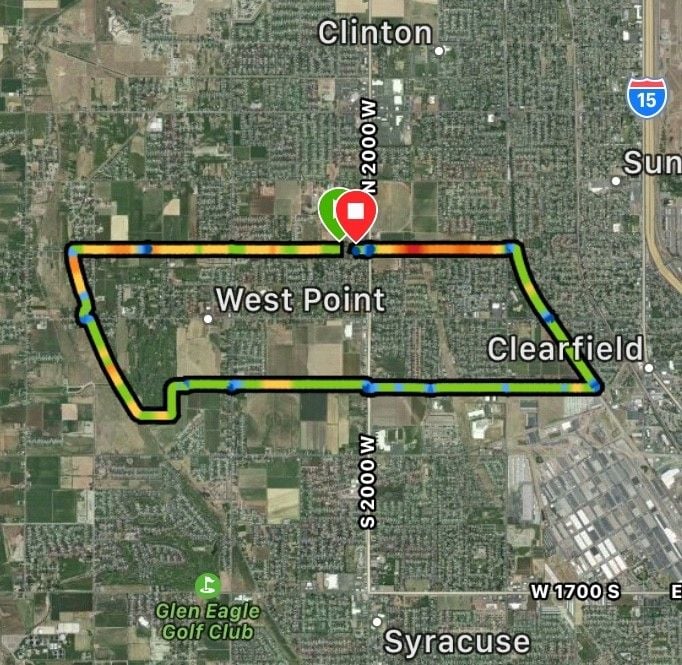
Edit: Looking at the map, I realize it's technically more of a parallelogram, with slightly curved ends.
At one end of the rectangle, there is pretty scenery, especially at sunset. At the opposite end, there are lots trees and a pond. The long sides take us through residential neighborhoods and farm fields. There are no commercial, industrial, or urban areas.
The route sits on a slight incline, not steep, but just enough slope to make it interesting. We can choose how we want to take the incline by riding the loop clockwise or counter-clockwise: descent at the beginning and end of the ride with climbing in the middle, or climbing at the start and end with descent in the middle.
We ride this quite often, and I've also walked and jogged all or part of it many times. It is one of my favorite things about the place where we live.
Edit: Looking at the map, I realize it's technically more of a parallelogram, with slightly curved ends.
10-25-21, 12:16 PM
#69
Full Member
My typical ride is about 12 mi. and is usually as the sun rises. Abt a 1/3 of the ride edges the Stevens Creek on an MUP (The Stevens Creek trail....mostly quiet at that time of the morning). For a change up (usually once a week), I can follow the MUP all the way out to the SF Bay for ~30 mi. R/T. Lots of water fowl to be seen: White, Black-Tipped Pelicans, California Brown Pelicans, 4-5 species of duck (including wood, teal and mallard), egrets, herons (blue and black-crested night) Canada geese, Avocets, Sandpipers and lots and lots of seagulls (especially when a storm is on its way). Occasionally see jackrabbits and Golden Eagles along with red-tailed hawks. Hard to pay attention to where you're going when looking at the wonderful scenery. Silicon Valley is also bounded by the Santa Cruz Mtns. on the west and the eastern foothills in the east (well, duh! Seen some amazing sunrises over the east foothills.
Planning to modifiy my route so I can still make a longer ride when the trail out by the bay gets all muddied up like from the recent rains we just had ("Bomb Cyclone" or "Atmospheric River"?).
Seen some amazing sunrises over the east foothills.Planning to modifiy my route so I can still make a longer ride when the trail out by the bay gets all muddied up like from the recent rains we just had ("Bomb Cyclone" or "Atmospheric River"?).
10-25-21, 12:52 PM
#70
Full Member
I live in waltham, MA, about ten miles from where I work in Boston's back bay.
But my most regular because I want to ride is to head west on route 117, and wind up on great back, country roads in Westin, Lincolna and other towns. I go past the Dcordova Museum (a modern art museum surrounded by a huge sclupture park), past the gropeius house, past Walden, and into Concord center. Sometimes I go Carlisle. Those roads are great, rural, they go past horse farms and vegetable frams, ponds and lakes, battlefields from the revolutionayr war, etc. 20 to 35 miles, depending on what I do.
But my most regular because I want to ride is to head west on route 117, and wind up on great back, country roads in Westin, Lincolna and other towns. I go past the Dcordova Museum (a modern art museum surrounded by a huge sclupture park), past the gropeius house, past Walden, and into Concord center. Sometimes I go Carlisle. Those roads are great, rural, they go past horse farms and vegetable frams, ponds and lakes, battlefields from the revolutionayr war, etc. 20 to 35 miles, depending on what I do.
10-25-21, 02:12 PM
#71
Senior Member
That's close to area I roll often. I hate losing ride time driving places since I have kids, but I make it up that way often. With more time I go longer on the piece out to the marina and back also. I know "when" it is a decent time to go.
This is a "go to" route of about 2 hours for me that similar area:
https://www.strava.com/activities/6156322917
This is a "go to" route of about 2 hours for me that similar area:
https://www.strava.com/activities/6156322917
. I sent you a Strava request...
10-25-21, 04:56 PM
#72
Full Member
I live in Bend Oregon so for road-ish rides we use the Larkspur trail to loop through town and maybe part of the Deschutes River path. Off-road we like the DRT and our new favorite is the Metolius Preserve, although it's a bit of a drive.
10-25-21, 05:25 PM
#73
Senior Member
Used to live in Hillsboro (like the Hillsborough in Nor. Cal., but without the "ugh" at the end decades ago. Was not into cycling at the time (married to the wrong woman but drove the Columbia Gorge many times. Beautiful drive. So many waterfalls along the way. Can actually take it all the way to Boise, ID, if one has the time. Also can do a "u-turn" at Bridge of the Gods and return on the WA side of the Columbia. Hmmmm...maybe I'll put that on my bucket list for a near-future getaway trip....cheers....
decades ago. Was not into cycling at the time (married to the wrong woman but drove the Columbia Gorge many times. Beautiful drive. So many waterfalls along the way. Can actually take it all the way to Boise, ID, if one has the time. Also can do a "u-turn" at Bridge of the Gods and return on the WA side of the Columbia. Hmmmm...maybe I'll put that on my bucket list for a near-future getaway trip....cheers....
10-25-21, 05:30 PM
#74
Full Member
10-25-21, 07:18 PM
#75
Senior Member
Join Date: Oct 2008
Location: Portland, OR
Posts: 4,075
Bikes: Trek Domane SL6 Gen 3, Soma Fog Cutter, Focus Mares AL, Detroit Bikes Sparrow FG, Volae Team, Nimbus MUni
Liked 2,322 Times
in
1,220 Posts
A couple generations later, when his grandkids are still living on the property formerly yours, and your grandkids have moved back to the area, imagine what they think when they realize his grandkids built a gazebo in the old backyard, and call it "Trek 520" because you had a Trek 520 hanging in your garage back in the day. The gazebo builders think it's a quaint name, and it honors the people who lived there before.
Does anybody alive at the end of the story feel offended?
It's a weird story, but truth is stranger than fiction.