


does this route seem reasonable?
 05-02-24, 07:03 PM
#1
Senior Member
Thread Starter
does this route seem reasonable?
I am landing at Barcelona airport on May 8th with my Bike Friday bike + trailer assembly.
Start BCN airport. End point Chamonix France around May 28th. there should be enough time.
my plan is to just ride straight from the airport.
I've done this before. I sort of know my limitations.
I also know this area well.
I a 66 but "Bike Fit"
this trip I would like to avoid the coast (even though I know that the costa brava coast ride is kinda sublime. but I know it)
and so I was going t head inland.
problem being Inland is the Pyrenees.
which Yes I would like to explore but I wasn't planning on col bagging with the full trailer.
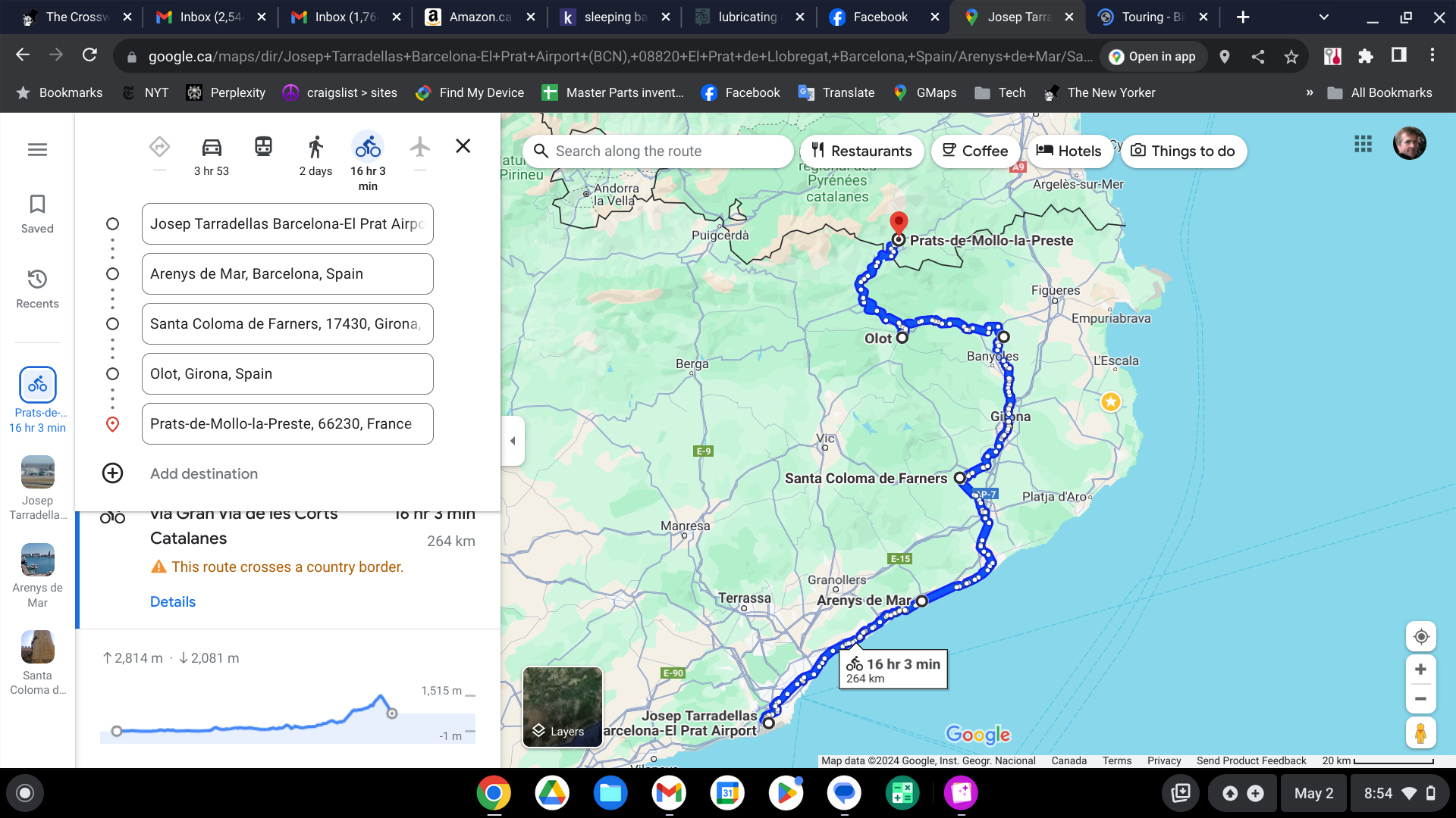
this route I have sketched out tops out at 1515m / 5000ft.
but I would have been building to this over 2 or 3 days
Question. am i insane to think I can summit 1515m with a fully loaded trailer ( 3 days after getting off a plane)?
Start BCN airport. End point Chamonix France around May 28th. there should be enough time.
my plan is to just ride straight from the airport.
I've done this before. I sort of know my limitations.
I also know this area well.
I a 66 but "Bike Fit"
this trip I would like to avoid the coast (even though I know that the costa brava coast ride is kinda sublime. but I know it)
and so I was going t head inland.
problem being Inland is the Pyrenees.
which Yes I would like to explore but I wasn't planning on col bagging with the full trailer.
this route I have sketched out tops out at 1515m / 5000ft.
but I would have been building to this over 2 or 3 days
Question. am i insane to think I can summit 1515m with a fully loaded trailer ( 3 days after getting off a plane)?
 05-02-24, 07:11 PM
#2
Senior Member
Thread Starter
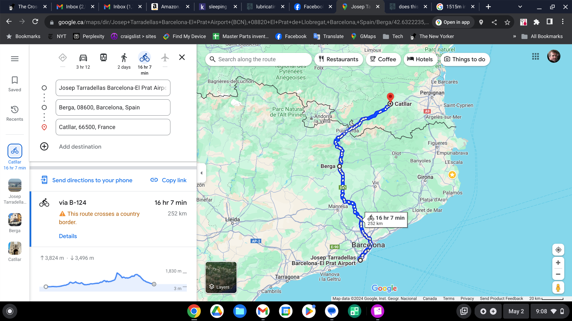
or here's another option.
which goes even higher.
there are only so many options across the Pyrenees it seems
(they don't call them the Bas - Low - Pyrenees - the other stretch which is only 1515m) for nothing I guess)
which goes even higher.
there are only so many options across the Pyrenees it seems
(they don't call them the Bas - Low - Pyrenees - the other stretch which is only 1515m) for nothing I guess)
Last edited by pstock; 05-02-24 at 07:28 PM.
05-02-24, 10:24 PM
#3
Senior Member

Doable with a super granny gear and very good brakes for the descent. You can use google street to see if there are any hard ascents by looking at road signs. Looks like an incredible route.
Best of luck to ya
Best of luck to ya
 05-03-24, 08:06 AM
#5
Senior Member
Thread Starter
But actually looking at the weather report I am seeing highs of about 17C / 63F.
I could do that.
05-03-24, 08:16 AM
#6
bicycle tourist
Are you concerned about the overall elevation, the steepness of climbs and descents or the total amount of climbing in a day?
Depending on which I might take different approaches:
- As far as overall elevation goes, everyone is different but I consider 1500m as not particularly high. It is similar elevation as Denver and most everyone I am aware does fine there. A lot more differences at say 3000m or then going higher from there. So without knowing your specific situation my guess is not to worry and having a few days of riding before can help.
- If your concern is amount of climb/descent per day then I would point back to your existing experiences around your start, again people are different but you likely have some knowledge of how much climbing you find too much or not in a day. You might also be able to adapt by making some days slightly shorter riding if otherwise there is much climbing.
- If your concern is with the steepness of individual climbs/descents - this for me is a boundary of when things become too steep that I either make sure I have sufficient gearing or is even steeper where I would just get off an walk a short stretch. I'd want to double check the route more closely to see how steep individual climbs are at.
Tough to know your exact situation, though what you describe doesn't set off particular alarm bells.
Looking using RideWithGPS, the following section appears the most challenging to me:
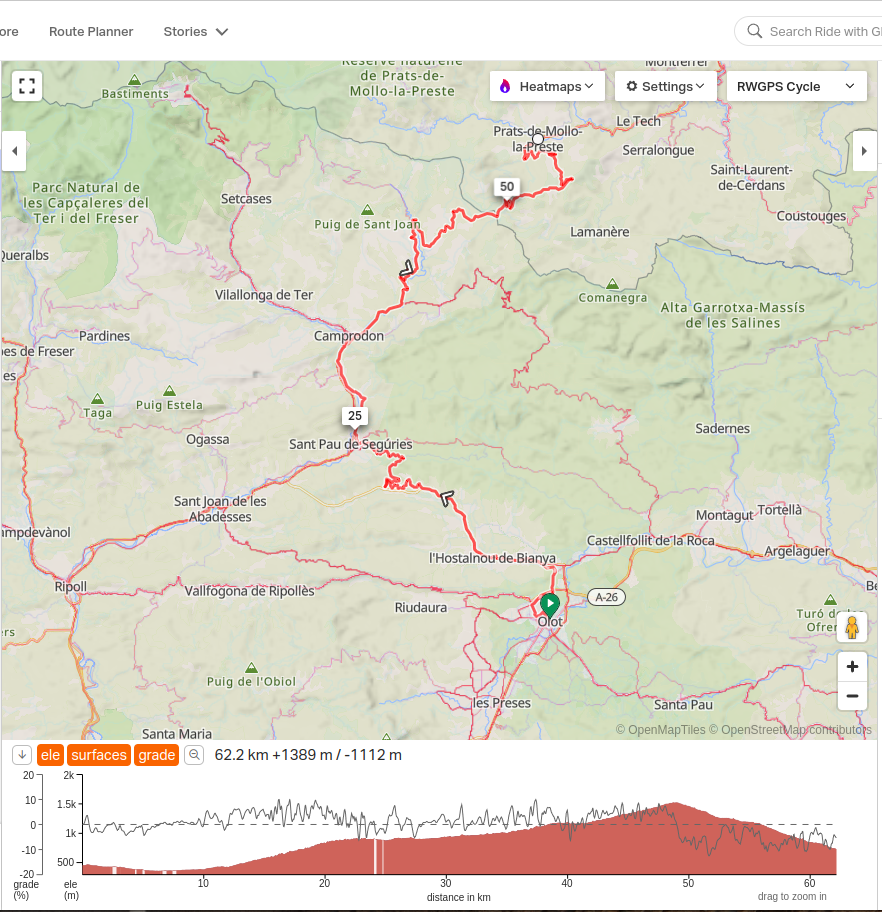
Not particularly high overall at 1500m. The distance of 62km also not that far. However, in that distance RWGPS calculates a bunch of up/down and totaling ~1300m depending on how that actually unfolds could be a longer day.
Depending on which I might take different approaches:
- As far as overall elevation goes, everyone is different but I consider 1500m as not particularly high. It is similar elevation as Denver and most everyone I am aware does fine there. A lot more differences at say 3000m or then going higher from there. So without knowing your specific situation my guess is not to worry and having a few days of riding before can help.
- If your concern is amount of climb/descent per day then I would point back to your existing experiences around your start, again people are different but you likely have some knowledge of how much climbing you find too much or not in a day. You might also be able to adapt by making some days slightly shorter riding if otherwise there is much climbing.
- If your concern is with the steepness of individual climbs/descents - this for me is a boundary of when things become too steep that I either make sure I have sufficient gearing or is even steeper where I would just get off an walk a short stretch. I'd want to double check the route more closely to see how steep individual climbs are at.
Tough to know your exact situation, though what you describe doesn't set off particular alarm bells.
Looking using RideWithGPS, the following section appears the most challenging to me:
Not particularly high overall at 1500m. The distance of 62km also not that far. However, in that distance RWGPS calculates a bunch of up/down and totaling ~1300m depending on how that actually unfolds could be a longer day.
Last edited by mev; 05-03-24 at 08:32 AM.
05-03-24, 08:45 AM
#7
Senior Member
Thread Starter
But primarily it is Steepness of Climbs that concerns me. (plus possibly cold temperatures which I find can sap my energy fast - but I'll have gloves, hat, longs and a jacket)
if I was just riding solo, I would have no concerns (except the cold)
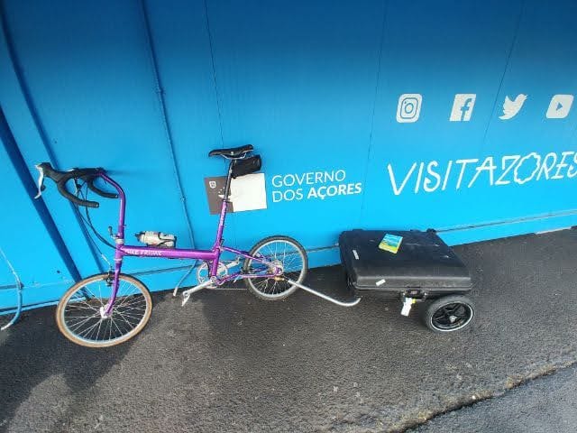
My Bike Friday is geared to climb
but towing a trailer is a different animal.
on past tours I have faced steep pitches (I don't remember the grade) that while short have almost broken me.
that trailer goes from moving well to feeling like a stone anchor.
One, was only about 200m long (in town in the Canary Islands and I had to get up it to get to my hostel) I might have had to push the rig up the last stretch. I can't remember now.
But you are correct. it looks slow and steady. if I just keep doing Left Right Left Right I find I can surmount almost anything.
But it's also the unknownness of it all that makes me anxious. I'll have just got off the plane. I am not in End Of Summer riding condition.
But I am probably just being a Nervous Nelly.
 05-03-24, 09:26 AM
#8
Senior Member
Join Date: Aug 2010
Location: Madison, WI
Posts: 11,550
Bikes: 1961 Ideor, 1966 Perfekt 3 Speed AB Hub, 1994 Bridgestone MB-6, 2006 Airnimal Joey, 2009 Thorn Sherpa, 2013 Thorn Nomad MkII, 2015 VO Pass Hunter, 2017 Lynskey Backroad, 2017 Raleigh Gran Prix, 1980s Bianchi Mixte on a trainer. Others are now gone.
Liked 1,586 Times
in
1,228 Posts
At that elevation, you should not have difficulty breathing, but if you live at an elevation of a few hundred meters above sea level and if you have any respiratory difficulty, that higher elevation could be an issue.
If the downhill is steep, stop a few times to see if your rims are getting hot. With small wheels you have less rim than most of us and you do not want a rim that is hot enough to cause a tire problem on a fast descent.
Photo below, I knew before I left home that this particular hill was going to be one that I walked up it. At 13 percent, that is quite noticeable. I just made sure that I budgeted some time for that. I started really early in the morning so that there was not much traffic on the hill at the same time I was there. But your hill will be a lot more total elevation above MSL than the photo below. So, you will be there for a few more hours, need more water, etc.

I have probably posted this photo on this forum a dozen times, but I keep coming up with reasons to post it.
Different topic - I have followed Bike Friday riders with trailers before, and they are not that visible to traffic from behind because the trailer is so low. With the three tire tracks instead of one, you are often further into a traffic lane than a bike with no trailer.
Have you considered mounting one of those fiberglass flag poles on your bike? The flag that flutters in the breeze is enough movement to usually get the attention of drivers from behind. Or, perhaps some high visibility clothing along with some high visibility stickers on the rear of the trailer?
If the downhill is steep, stop a few times to see if your rims are getting hot. With small wheels you have less rim than most of us and you do not want a rim that is hot enough to cause a tire problem on a fast descent.
Photo below, I knew before I left home that this particular hill was going to be one that I walked up it. At 13 percent, that is quite noticeable. I just made sure that I budgeted some time for that. I started really early in the morning so that there was not much traffic on the hill at the same time I was there. But your hill will be a lot more total elevation above MSL than the photo below. So, you will be there for a few more hours, need more water, etc.
I have probably posted this photo on this forum a dozen times, but I keep coming up with reasons to post it.
Different topic - I have followed Bike Friday riders with trailers before, and they are not that visible to traffic from behind because the trailer is so low. With the three tire tracks instead of one, you are often further into a traffic lane than a bike with no trailer.
Have you considered mounting one of those fiberglass flag poles on your bike? The flag that flutters in the breeze is enough movement to usually get the attention of drivers from behind. Or, perhaps some high visibility clothing along with some high visibility stickers on the rear of the trailer?
05-03-24, 12:05 PM
#9
aka Timi
The Costa Brava from Barcelona to Lloret de Mar is heavily built up and very densely trafficked. After that, the coast road is scenic.
From Barcelona airport all the way to Vic you can get the commuter train. Cheap and easy.
After that, the by far easiest way across the Pyrenees is Vic-Olot-Banyoles-Figueres-La Jonquera.
Then in France I�d recommend dropping down to Argeles-sur-Mer and following the coast to S�te which joins up with the Via Rhona. Follow that to Geneva.
pm me if that route is interesting. I�ve got google map routes with good camping places along the way. Been going up and down and round those parts for the last 45 years
