


Why I don't trust route choices from Ride With GPS
 07-24-23, 03:39 PM
#1
bicycle tourist
Thread Starter
Why I don't trust route choices from Ride With GPS
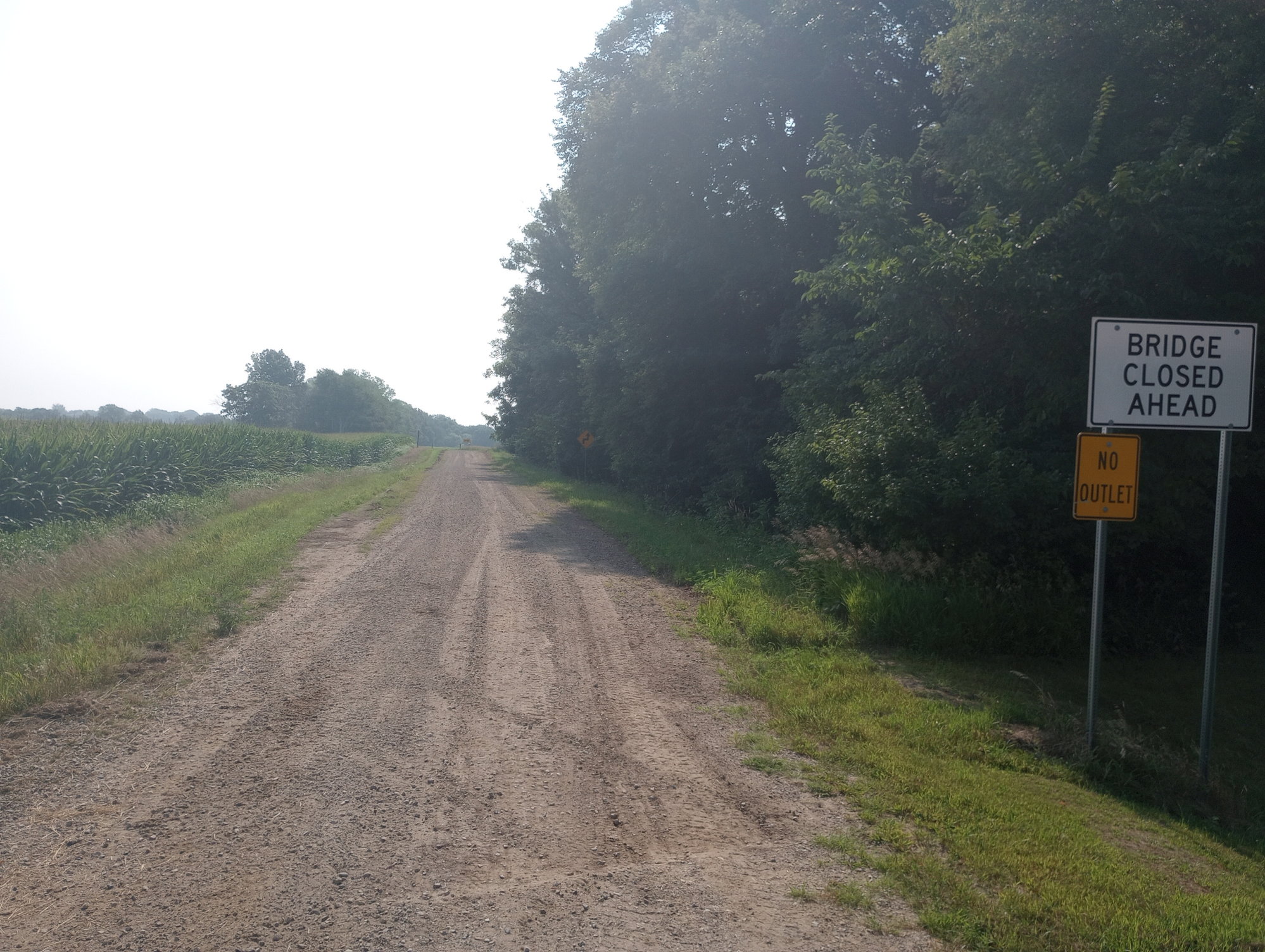
Today, a Ride With GPS route in near Rowan Iowa routed me to this small road. The ride was listed as "100% paved". A little past this sign, the road ends and there isn't much of either a path or a bridge to easily see...
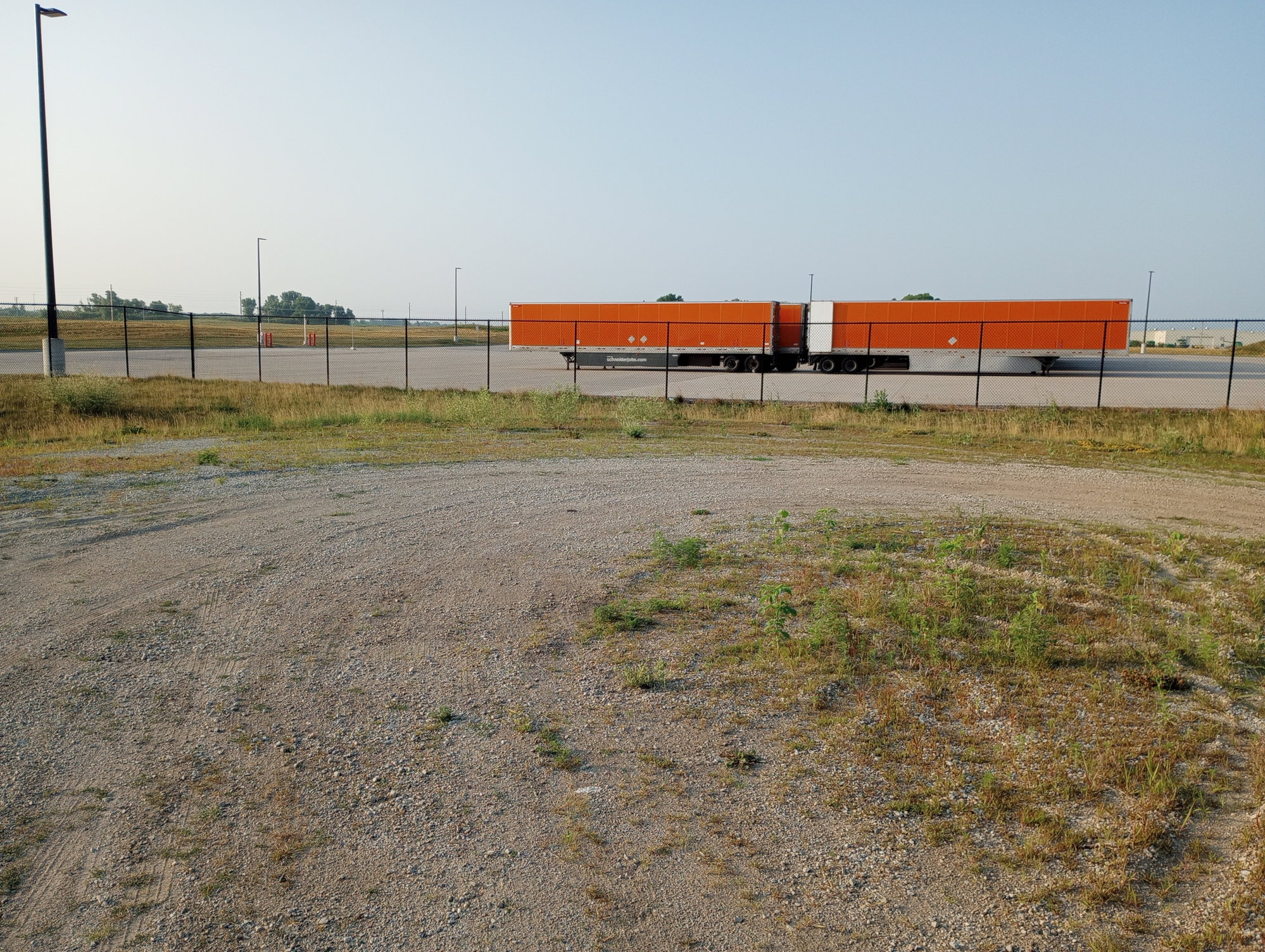
Yesterday a little south of Albert Lea Minnesota, a Ride With GPS route sent me down this gravel road (also listed as paved). At the end was this chain link fence and no easy way to get around it...
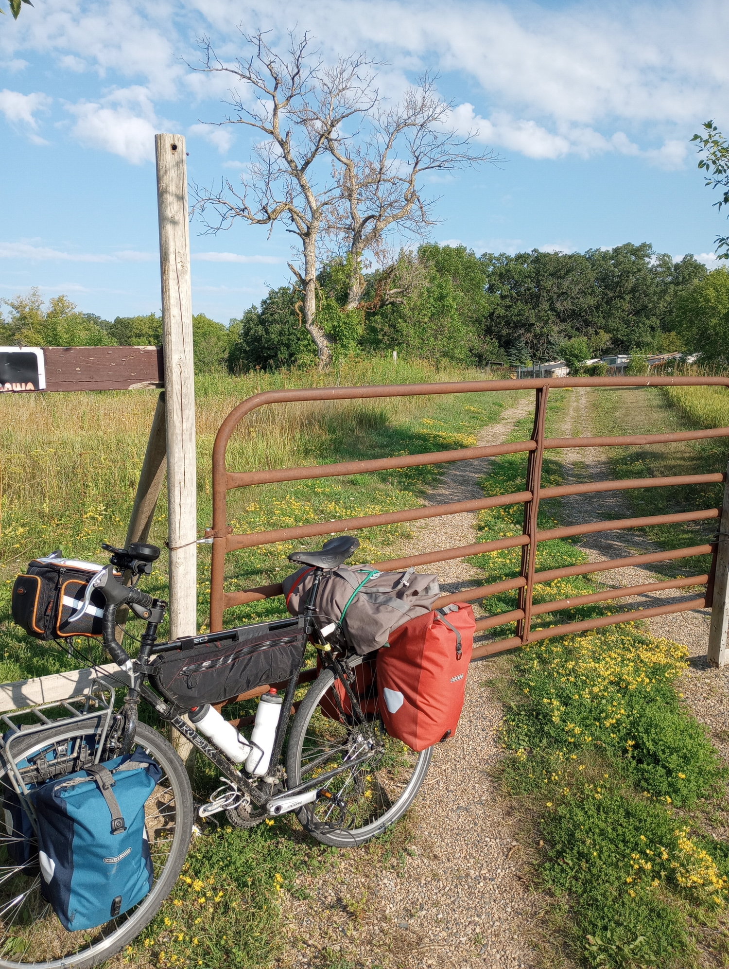
The day before close to Fairibault Minnesota, a Ride with GPS route sent me via the private road on other side of this fence, also listed as paved. I was able to get around the gate before taking the photo.
Whatever underlying maps being used with Ride With GPS have particular problems with this part of Iowa and Minnesota. In Indiana and Illinois, I had previously encountered the situation where RWGPS says roads are paved when they actually were gravel. In Maryland and other places, I had encountered situations where RWGPS goes across bridges that have been closed for a while.
Yesterday a little south of Albert Lea Minnesota, a Ride With GPS route sent me down this gravel road (also listed as paved). At the end was this chain link fence and no easy way to get around it...
The day before close to Fairibault Minnesota, a Ride with GPS route sent me via the private road on other side of this fence, also listed as paved. I was able to get around the gate before taking the photo.
Whatever underlying maps being used with Ride With GPS have particular problems with this part of Iowa and Minnesota. In Indiana and Illinois, I had previously encountered the situation where RWGPS says roads are paved when they actually were gravel. In Maryland and other places, I had encountered situations where RWGPS goes across bridges that have been closed for a while.
 07-24-23, 05:05 PM
#2

Senior Member
What tire size are you running? That doesn't seem much of a gravel road to me.
IF they are the shortest distance between two points I would welcome them. Heck if they are the same distance I would still pick the gravel road just for variety.
You should come to Alaska, a gravel road is not worth mentioning unless it has a few river crossings on them.
IF they are the shortest distance between two points I would welcome them. Heck if they are the same distance I would still pick the gravel road just for variety.
You should come to Alaska, a gravel road is not worth mentioning unless it has a few river crossings on them.
07-24-23, 06:25 PM
#3
Palmer

Join Date: Mar 2007
Location: Parts Unknown
Posts: 8,627
Bikes: Mike Melton custom, Alex Moulton AM, Dahon Curl
Mentioned: 37 Post(s)
Tagged: 0 Thread(s)
Quoted: 1670 Post(s)
Liked 1,825 Times
in
1,062 Posts
The paved/gravel indication on RWGPS is, charitably, unreliable. I double-check with Streetview and/or Google Earth.
Likes For tcs:
07-24-23, 06:32 PM
#4
Hooked on Touring
I found about a half dozen paved/unpaved errors the day their pavement app came out.
When I posted my criticisms I was called a Debbie Downer.
RWGPS, Google, and other apps often route you on private roads or non-existent roads.
Especially in the West and in remote locations. Not good.
And on old roads with bridges that haven't been there for 18 years.
Which is why it is always best to use "Car" mode rather than "Bike" mode.
Then gradually shift over to more local roads bit by bit.
It's an app - don't forget.
The app has never - not once - biked the route!
YMMV
Likes For jamawani:
07-24-23, 06:35 PM
#5
Senior Member
Join Date: Jan 2010
Posts: 39,249
Mentioned: 211 Post(s)
Tagged: 1 Thread(s)
Quoted: 18420 Post(s)
Liked 15,565 Times
in
7,334 Posts
I was always under the impression that RWGPS uses Google Maps.
As noted above, the paved/unpaved feature is not always accurate. I�ve seen it go both ways. Unpaved shown as paved and vice versa.
As noted above, the paved/unpaved feature is not always accurate. I�ve seen it go both ways. Unpaved shown as paved and vice versa.
07-25-23, 05:23 AM
#6
bicycle tourist
Thread Starter
Typically I've done either my routing before the day - in which case I sometimes adjusted my gravel/non-gravel to match expectations or mid-ride to react to construction, traffic, etc. I'll spot check street view but not for an entire route, particularly if I reroute on the fly.
What is more of a pain are road closures, particularly those I can't easily avoid. RideWithGPS was an easier 1st choice for routing in more populated areas but as I get to less populated parts of the US, I'm switching more to other methods like maps or state bike maps or following numbered routes.
07-25-23, 05:29 AM
#7
bicycle tourist
Thread Starter
Most of the gravel/pavement mixes I see are on very lightly traveled routes so there may be a default if they don't know the road to assume pavement.
07-25-23, 05:37 AM
#8
Junior Member
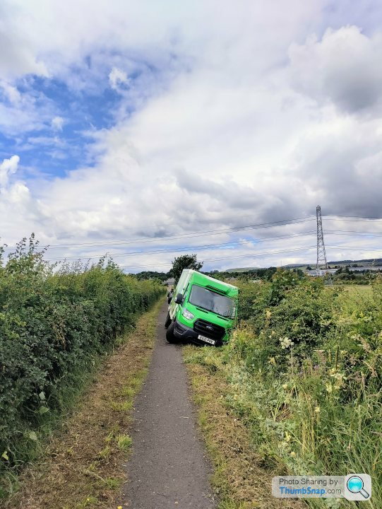
I passed this guy. His satnav told him this footpath was a road. He believed his screen rather than his eyes.
Likes For irc:
07-25-23, 07:43 AM
#9
Senior Member
Join Date: Feb 2016
Location: SE Wisconsin
Posts: 1,852
Bikes: Lemond '01 Maillot Jaune, Lemond '02 Victoire, Lemond '03 Poprad, Lemond '03 Wayzata DB conv(Poprad), '79 AcerMex Windsor Carrera Professional(pur new), '88 GT Tequesta(pur new), '01 Bianchi Grizzly, 1993 Trek 970 DB conv, Trek 8900 DB conv
Mentioned: 12 Post(s)
Tagged: 0 Thread(s)
Quoted: 759 Post(s)
Likes: 0
Liked 810 Times
in
471 Posts
RWGPS isn't in the map creation or maintenance business(digital cartography). They are in the business of developing/using software that utilizes existing digital maps and meta-data associated with them.
I think RWGPS uses Open Street Maps as their base. OSM undoubtedly sources their map data from someone else or most likely multiple sources, depending on what data/metadata is needed. OSM uses crowd-sourcing to improve the accuracy of their maps(see link below).
https://support.ridewithgps.com/hc/e...3-OSM-Map-Data
Likes For fishboat:
07-25-23, 10:06 AM
#10
Senior Member
It is more a question of expectations than anything else. I am running 700x35 and have ridden this bike down the Dalton Highway and also across Russia in 2007 before that road was completely sealed, (~1500km of gravel). I've ridden other extended sections of gravel in Argentina and other places. Over time, I've come to learn a wide variety of gravel road conditions as far as how much loose stuff, how much washboard and what happens when the road gets wet. I can ride these fine but is useful to adjust expectations in advance.
Typically I've done either my routing before the day - in which case I sometimes adjusted my gravel/non-gravel to match expectations or mid-ride to react to construction, traffic, etc. I'll spot check street view but not for an entire route, particularly if I reroute on the fly.
What is more of a pain are road closures, particularly those I can't easily avoid. RideWithGPS was an easier 1st choice for routing in more populated areas but as I get to less populated parts of the US, I'm switching more to other methods like maps or state bike maps or following numbered routes.
The absolute worst for us was in Japan, a closed road turned what was supposed to be a 40 mile day into a 70 mile day going over a mountain with a wicked incline that had us pedaling well past darkness. I was still having fun but it took a toll on my daughter. I'm glad we were credit card touring that trip, it would have sucked to have to set up camp that late. And that was day one; we wanted to squeeze in a very aggressive schedule where the first day was a warm up but after that my daughter needed a light day to recover.
07-25-23, 10:29 AM
#11
Senior Member
Join Date: Dec 2010
Location: northern Deep South
Posts: 8,904
Bikes: Fuji Touring, Novara Randonee
Mentioned: 36 Post(s)
Tagged: 0 Thread(s)
Quoted: 2604 Post(s)
Liked 1,933 Times
in
1,213 Posts
RWGPS isn't in the map creation or maintenance business(digital cartography). They are in the business of developing/using software that utilizes existing digital maps and meta-data associated with them.
I think RWGPS uses Open Street Maps as their base. OSM undoubtedly sources their map data from someone else or most likely multiple sources, depending on what data/metadata is needed. OSM uses crowd-sourcing to improve the accuracy of their maps(see link below).
https://support.ridewithgps.com/hc/e...3-OSM-Map-Data
I think RWGPS uses Open Street Maps as their base. OSM undoubtedly sources their map data from someone else or most likely multiple sources, depending on what data/metadata is needed. OSM uses crowd-sourcing to improve the accuracy of their maps(see link below).
https://support.ridewithgps.com/hc/e...3-OSM-Map-Data
07-25-23, 06:10 PM
#12
Senior Member
Join Date: Apr 2013
Posts: 1,173
Bikes: Surly Disk Trucker, 2014 w/Brooks Flyer Special saddle, Tubus racks - Duo front/Logo Evo rear, 2019 Dahon Mariner D8, Both bikes share Ortlieb Packer Plus series panniers, Garmin Edge 1000
Mentioned: 2 Post(s)
Tagged: 0 Thread(s)
Quoted: 405 Post(s)
Liked 115 Times
in
99 Posts
On the subject of "route planning" -
Use multiple sources.
I do use RWGPS, a LOT, for routing. However, it is not the only resource I use. In fact, I don't really use the paved/non-paved routing features at all on RWGPS. I cross reference routing with Google Maps, Street Level imagery, and physical viewing. I've driven some routes and walked out to some areas I was curious about on a route - obviously, closer to home where I can do that - or incorporate it in to another outing out in a direction with a bike route of mine.
For areas I am not able to physically get to beforehand - satellite imagery is wonderful (bing maps, google maps). Some areas, if you are lucky, may have street level imagery you can check as well.
One thing to watch out for is wide shoulders, or lack there of, on roadways - especially 2 lane routes.
Personally, I look for more desolate roads as opposed to numbered state routes. Around here (central Ohio) the numbered state routes carry a lot of traffic - including semi traffic. I really don't care to ride on heavily traveled roads. When you get off of the state routes the country roads are pretty nice to ride, in my opinion. There, of course, are risks with both. And sometimes you just can't avoid running a state route for a bit.
Best of luck in your routing adventures.
Likes For KC8QVO:
07-25-23, 07:18 PM
#13
Senior Member
Join Date: Jul 2007
Location: South shore, L.I., NY
Posts: 6,885
Bikes: Flyxii FR322, Cannondale Topstone, Miyata City Liner, Specialized Chisel, Specialized Epic Evo
Mentioned: 18 Post(s)
Tagged: 0 Thread(s)
Quoted: 3242 Post(s)
Liked 2,086 Times
in
1,181 Posts
No web based or paper mapping company is able to keep track of when local towns, counties, etc…, decide to pave a gravel road. It’s done all the time and the local authorities are not in the habit of notifying these mapping companies.
Last edited by Steve B.; 07-25-23 at 08:31 PM.
07-25-23, 07:26 PM
#14
Senior Member
Join Date: Oct 2008
Location: Portland, OR
Posts: 3,843
Bikes: Trek Domane SL6 Gen 3, Soma Fog Cutter, Focus Mares AL, Detroit Bikes Sparrow FG, Volae Team, Nimbus MUni
Mentioned: 11 Post(s)
Tagged: 0 Thread(s)
Quoted: 896 Post(s)
Liked 2,065 Times
in
1,081 Posts
RWGPS + heatmaps is decent. The presence of heat doesn't mean it's good, but the absence of heat says don't go there.
07-25-23, 07:59 PM
#15
Cantilever believer

Join Date: Nov 2021
Location: Phoenix, AZ
Posts: 1,565
Mentioned: 5 Post(s)
Tagged: 0 Thread(s)
Quoted: 536 Post(s)
Liked 1,838 Times
in
831 Posts
One of the "hottest" corridors in our area on RWGPS within a city park connecting two neighborhoods is rather rough singletrack. Google Bike Maps loves to suggest it as a route home from downtown. If I tried to take most of my bikes on it, I'd be doing a lot of cyclocross-style portaging. But another "hot" corridor a few miles east in similar terrain is a wide paved concrete path. So consulting other information sources prior to committing to a new RWGPS routing may be advisable.
__________________
Richard C. Moeur, PE - Phoenix AZ, USA
https://www.richardcmoeur.com/bikestuf.html
Richard C. Moeur, PE - Phoenix AZ, USA
https://www.richardcmoeur.com/bikestuf.html
07-26-23, 04:11 AM
#16
Senior Member
Join Date: Apr 2013
Posts: 1,173
Bikes: Surly Disk Trucker, 2014 w/Brooks Flyer Special saddle, Tubus racks - Duo front/Logo Evo rear, 2019 Dahon Mariner D8, Both bikes share Ortlieb Packer Plus series panniers, Garmin Edge 1000
Mentioned: 2 Post(s)
Tagged: 0 Thread(s)
Quoted: 405 Post(s)
Liked 115 Times
in
99 Posts
One of the "hottest" corridors in our area on RWGPS within a city park connecting two neighborhoods is rather rough singletrack. Google Bike Maps loves to suggest it as a route home from downtown. If I tried to take most of my bikes on it, I'd be doing a lot of cyclocross-style portaging. But another "hot" corridor a few miles east in similar terrain is a wide paved concrete path. So consulting other information sources prior to committing to a new RWGPS routing may be advisable.
When I was in IL for a few years I rode a lot around the Illinois and Michigan Canal Trail. That area is very popular for cyclists. However, the bulk of the cycle traffic running Strava appears to be road riders. That seems to parallel what I saw when I was out there - several large group rides around there. If you get groups of 15-20 people through a particular area routinely that 80-90% of them are running Strava it tends to skew the data. What you end up with is a trail that doesn't look as heavily traveled as the roads paralleling it.
There is a caveat with most sources most of the time. When you use multiples you can decipher your route ideas better. That way you have more information that has a better chance at illuminating something you may not see on a few other sources.
Don't forget elevation and your inclines. If one route has a higher elevation gain over the distance you are going it may still be a better route than a little lower elevation gain route that has one or two long steep grades. RWGPS is good for finding these.
07-26-23, 05:38 AM
#17
Senior Member
throw in a bit of green in both senses, and you get this.
Great eh?
07-26-23, 06:10 AM
#18
Senior Member
None of the mapping choices are perfect. Using heatmaps as an added reality check helps, but out in the sticks there can be some big swaths with no "heat".
In any case any of the electronic maps are likely to be more up to date and accurate than the paper maps we were likely to be stuck with some number of decades ago (I am not talking about ACA maps).
In any case any of the electronic maps are likely to be more up to date and accurate than the paper maps we were likely to be stuck with some number of decades ago (I am not talking about ACA maps).
07-26-23, 08:27 AM
#20
Senior Member
Join Date: Sep 2007
Location: Far beyond the pale horizon.
Posts: 14,278
Mentioned: 31 Post(s)
Tagged: 0 Thread(s)
Quoted: 4260 Post(s)
Liked 1,363 Times
in
945 Posts
It's expensive and hard to get mapping data. That's even worse in places that don't see much traffic.
RWGPS uses map data from other sources (mostly Google and Openstreetmap). Openstreetmap (OSM) is going to be less reliable in rural areas. But even the mighty Google has issues at times.
Mapping databases are going to assume roads are paved based on the type/classification of road. The status of being unpaved is information that people have to add explicitly (especially in OSM).
This is more of a case of you using the tool wrong.
You should be using satellite view, especially in rural/remote places. One big advantage of RWGPS is that it makes these tools very accessible.
Most roads don't have an explicit paved/unpaved status. So, yes, "users" (like RWGPS) of the maps are assuming roads (without this data) are paved. The users can make any assumption they like but being paved is really the only sensible thing (in most places).
Last edited by njkayaker; 07-26-23 at 08:44 AM.
07-26-23, 08:33 AM
#21
Senior Member
Join Date: Sep 2007
Location: Far beyond the pale horizon.
Posts: 14,278
Mentioned: 31 Post(s)
Tagged: 0 Thread(s)
Quoted: 4260 Post(s)
Liked 1,363 Times
in
945 Posts
OSM built up their base map (years ago) using public sources. Now, things get updated in OSM only when a person updates them (using various sources). (I'm a fairly active OSM updater.)
Last edited by njkayaker; 07-26-23 at 08:37 AM.
07-26-23, 08:43 AM
#22
Senior Member
Join Date: Jun 2015
Location: North Central Wisconsin
Posts: 4,624
Mentioned: 14 Post(s)
Tagged: 0 Thread(s)
Quoted: 2976 Post(s)
Liked 1,182 Times
in
771 Posts
1.) I would never let a mapping program choose my routes. I make my own with RWGPS
2.) You can select the type of map you want in the upper right corner so you can cross check if roads actually exist
3.) RWGPS is only about ~50% correct on what roads are gravel vs. paved
This is a tool I have been using for gravel rides. But it does rely on user input for accuracy. I have marked up numerous gravel roads on this map.
https://gravelmap.com/
07-26-23, 09:12 AM
#23
Senior Member
Join Date: Mar 2010
Posts: 1,659
Mentioned: 7 Post(s)
Tagged: 0 Thread(s)
Quoted: 1248 Post(s)
Liked 1,323 Times
in
674 Posts
Over the past decade or so, my cycling experience has been greatly improved thanks to RideWithGPS and Garmin. Together, they've allowed me to explore new cycling locations all over the world, particularly when I use Google Street View in conjunction with them. It's hard to imagine cycling in new places without these tools now. The recent addition of heat maps has been a game changer as well, making route selection much easier. During my recent bike tour in Southern Vietnam, the heat map helped me out a few times when a road or bridge was washed out, and I needed to find alternate routes. It's amazing to think that I can travel almost anywhere in the world that's cycling-friendly and quickly build interesting routes, even with zero notice.
Has it routed me onto some stinkers, yes it has but that's on me for not looking it over first.
Has it routed me onto some stinkers, yes it has but that's on me for not looking it over first.
07-26-23, 09:18 AM
#24
Senior Member
Join Date: Sep 2007
Location: Far beyond the pale horizon.
Posts: 14,278
Mentioned: 31 Post(s)
Tagged: 0 Thread(s)
Quoted: 4260 Post(s)
Liked 1,363 Times
in
945 Posts
This is a tool I have been using for gravel rides. But it does rely on user input for accuracy. I have marked up numerous gravel roads on this map.
https://gravelmap.com/
https://gravelmap.com/
 It looks like that site is more of a "gravel rides I've done" database. One of the routes posted is 200 miles and indicated as being "half gravel".
It would be nice if they had some way of updating OSM, which is much. much more used.
It's a bit sad/ironic that the base map used on that site is from OSM.
Last edited by njkayaker; 07-26-23 at 09:26 AM.
07-26-23, 12:32 PM
#25
Senior Member
Join Date: Oct 2008
Location: Right where I'm supposed to be
Posts: 1,634
Bikes: Franklin Frames Custom, Rivendell Bombadil
Mentioned: 2 Post(s)
Tagged: 0 Thread(s)
Quoted: 117 Post(s)
Liked 209 Times
in
127 Posts
I used some GPS for driving on a trip once and that was the end of that affair. Frankly, growing up using paper maps, whether driving or cycling, was just as much a hit or miss as to the suitability of a road, or if it was even open. That's all part of the adventure of delving into the unknown. I think that expecting a paper map or mapping software to be the sole source for where to go is unrealistic. It may be sold as reliable and trustworthy, or implied, but still, use your inherent intelligence that no map or computer can match. Keep a heads up, both visually and "within". Nothing beats "being there" ! ((( awake )))