


Kananaskis > Sparwood conditions
 06-25-22, 08:58 AM
#1
Senior Member
Thread Starter
Join Date: Sep 2015
Location: QC Canada
Posts: 1,971
Bikes: Custom built LHT & Troll
Mentioned: 12 Post(s)
Tagged: 0 Thread(s)
Quoted: 846 Post(s)
Liked 149 Times
in
106 Posts
Kananaskis > Sparwood conditions
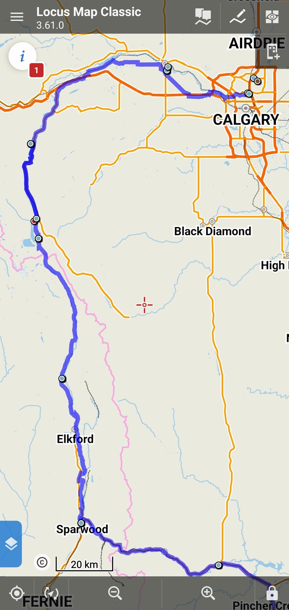
Flying out to Calgary tomorrow night. Below is screen capture of routing for the first couple of days. Wondering if the weather conditions (cold/wet spring, warnings that snow is still melting) suggest that I should rather bike east of the Rockies via #40, or stick to Elk Pass and #43.
Current plan is to reach Kananaskis Village and then advise. If someone here is familiar with the area and conditions, feel free to chime in.
Current plan is to reach Kananaskis Village and then advise. If someone here is familiar with the area and conditions, feel free to chime in.
 06-26-22, 06:26 AM
#2
Senior Member
Join Date: Jan 2010
Posts: 39,243
Mentioned: 211 Post(s)
Tagged: 1 Thread(s)
Quoted: 18418 Post(s)
Liked 15,558 Times
in
7,332 Posts
Not an answer, but thought I�d mention that the municipal campground in Sparwood was pretty nice when I stayed there in 2009.
Also, the NPS recently announced that Going to the Sun Road is not expected to open fully by the July 4th weekend. You�ll need to monitor the park�s official site for updates.
Photo accompanying the announcement.
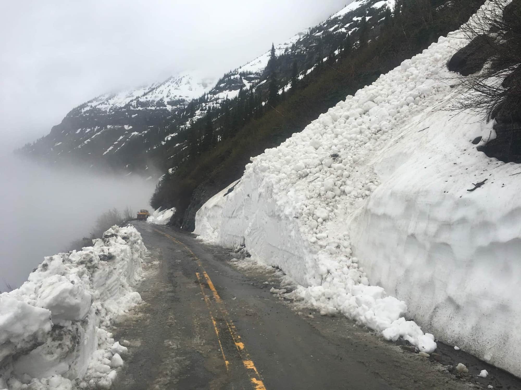
Also, the NPS recently announced that Going to the Sun Road is not expected to open fully by the July 4th weekend. You�ll need to monitor the park�s official site for updates.
Photo accompanying the announcement.
 06-26-22, 08:05 AM
#4
Senior Member
Join Date: Jan 2010
Posts: 39,243
Mentioned: 211 Post(s)
Tagged: 1 Thread(s)
Quoted: 18418 Post(s)
Liked 15,558 Times
in
7,332 Posts
06-26-22, 08:37 AM
#5
Senior Member
Thread Starter
Join Date: Sep 2015
Location: QC Canada
Posts: 1,971
Bikes: Custom built LHT & Troll
Mentioned: 12 Post(s)
Tagged: 0 Thread(s)
Quoted: 846 Post(s)
Liked 149 Times
in
106 Posts
West to East. Worse comes to worst, I'll ride south from St Mary.
Wife and daughter were supposed to be there as well. They cancelled this portion of our tour because my wife wanted to work on a project Now let's hope that we can ride Yellowstone...
Wife and daughter were supposed to be there as well. They cancelled this portion of our tour because my wife wanted to work on a project
Now let's hope that we can ride Yellowstone...
06-26-22, 10:55 AM
#6
Senior Member
Join Date: Jan 2010
Posts: 39,243
Mentioned: 211 Post(s)
Tagged: 1 Thread(s)
Quoted: 18418 Post(s)
Liked 15,558 Times
in
7,332 Posts
06-26-22, 11:13 AM
#7
Senior Member
Thread Starter
Join Date: Sep 2015
Location: QC Canada
Posts: 1,971
Bikes: Custom built LHT & Troll
Mentioned: 12 Post(s)
Tagged: 0 Thread(s)
Quoted: 846 Post(s)
Liked 149 Times
in
106 Posts
You're right. East to West. My mistake. WRT Chief Mountain, yes, I am aware that the border crossing has been closed for the past two years (COVID related...) I was hoping that it'd be reopened following the recent relaxation of COVID policies, but nothing has changed. So, slight detour.
06-26-22, 11:53 AM
#8
Senior Member
Join Date: Jan 2010
Posts: 39,243
Mentioned: 211 Post(s)
Tagged: 1 Thread(s)
Quoted: 18418 Post(s)
Liked 15,558 Times
in
7,332 Posts
East to Cardston and hang a right. When I did the Northern Tier route back in �99 ACA used Del Bonita south of Magrath on the way to Cut Bank. What a lonely 70+ miles that was. I remember one little store just north of the border. And the headwind was pretty evil. My riding partner and I finally stumbled into a cafe in Cut Bank super loopy. The other patrons all turned to look at us.
Expect a stiff headwind coming down 89 to St. Mary. At least you won�t have to do the climbing on Chief Mountain Highway. That is not an easy day.
Depending where the hiker/biker closure is, it might be worth setting up shop at either St. Mary or Rising Sun and riding as far up as you can then back down.
