


Best Tool For (Potentially) Safe Routing
 10-07-23, 07:33 PM
#1
20+mph Commuter
Thread Starter

Join Date: Jul 2007
Location: Greenville. SC USA
Posts: 7,517
Bikes: Surly LHT, Surly Lowside, a folding bike, and a beater.
Mentioned: 31 Post(s)
Tagged: 0 Thread(s)
Quoted: 1434 Post(s)
Liked 331 Times
in
219 Posts
Best Tool For (Potentially) Safe Routing
I am moving to Greenville, SC early next year and had zero clues how to find "safer" bike routes. I used Google Maps, BikeMap, and others and was pulling my hair out trying to piece together some safe routes starting at my neighborhood. It is super challenging to avoid main highways due to the proliferation of cul-de-sac style developments that do not interconnect being in vogue south of the city. But FINALLY I discovered Strava Global Heatmaps and TAA-DAA, everything I could ever want.
If you look at the attached screen capture the yellow arrow points to my new location. Using other methods the areas south of me looked like barren wastelands for cycling for the most part. Google maps shows established "Bike Routes" i.e., bike paths, Rail Trails, roads with bike lanes, but no actual info on where people ACTUALLY ride bikes.
If you aren't familiar with heat maps, the brighter the color (white being the most traveled) the more trips on those routes recorded by cyclists using Strava. Every little goat-trail short cut, back alley, and otherwise "secret" short cuts are fully exposed with the heat maps. You can zoom into the images as much as you want to and there are many different visual settings to suit your preferences.
I was very happy to see a network of "farm-to-market" roads south of my neighborhood light up like Vegas! Of course I used Google Earth to look at the roads I discovered through Heat Maps. Also several "hidden away" ATB trails in or very near the city lit up bright white as well. Google Bike Maps had no clue about those either.
So if you consider meandering country roads and off-road trails and fire roads to be safer than two-lane narrow and very heavily trafficked State Highways as I do, then this tool would be most useful to you, especially if you are relatively new to an area. I was also surprised to see some of the darker colors showing that a few people even cycle the busy roads UNLESS...they just forgot to turn off Strava before driving home with the bike on the car as is obvious on the Interstate highways and toll highway where bikes are strictly forbidden.
I know this would be relevant to the Bike Touring and Commuting forums but since my main interest was pleasure rides on relatively SAFE roads I chose to post this here. Mods can move as they please.
Cheers.
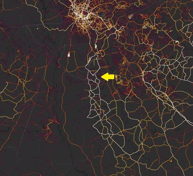
https://www.strava.com/heatmap#11.00...69810/hot/ride
If you look at the attached screen capture the yellow arrow points to my new location. Using other methods the areas south of me looked like barren wastelands for cycling for the most part. Google maps shows established "Bike Routes" i.e., bike paths, Rail Trails, roads with bike lanes, but no actual info on where people ACTUALLY ride bikes.
If you aren't familiar with heat maps, the brighter the color (white being the most traveled) the more trips on those routes recorded by cyclists using Strava. Every little goat-trail short cut, back alley, and otherwise "secret" short cuts are fully exposed with the heat maps. You can zoom into the images as much as you want to and there are many different visual settings to suit your preferences.
I was very happy to see a network of "farm-to-market" roads south of my neighborhood light up like Vegas! Of course I used Google Earth to look at the roads I discovered through Heat Maps. Also several "hidden away" ATB trails in or very near the city lit up bright white as well. Google Bike Maps had no clue about those either.
So if you consider meandering country roads and off-road trails and fire roads to be safer than two-lane narrow and very heavily trafficked State Highways as I do, then this tool would be most useful to you, especially if you are relatively new to an area. I was also surprised to see some of the darker colors showing that a few people even cycle the busy roads UNLESS...they just forgot to turn off Strava before driving home with the bike on the car as is obvious on the Interstate highways and toll highway where bikes are strictly forbidden.
I know this would be relevant to the Bike Touring and Commuting forums but since my main interest was pleasure rides on relatively SAFE roads I chose to post this here. Mods can move as they please.
Cheers.
https://www.strava.com/heatmap#11.00...69810/hot/ride

Likes For JoeyBike:
10-07-23, 07:48 PM
#2
Senior Member
Join Date: Jul 2007
Location: South shore, L.I., NY
Posts: 6,885
Bikes: Flyxii FR322, Cannondale Topstone, Miyata City Liner, Specialized Chisel, Specialized Epic Evo
Mentioned: 18 Post(s)
Tagged: 0 Thread(s)
Quoted: 3242 Post(s)
Liked 2,089 Times
in
1,182 Posts
Give RideWithGPS a look at, they’ll have a database of rides uploaded by users,
Likes For Steve B.:
10-07-23, 10:35 PM
#3


Senior Member
Join Date: Jul 2005
Posts: 5,994
Mentioned: 26 Post(s)
Tagged: 0 Thread(s)
Quoted: 2496 Post(s)
Liked 739 Times
in
523 Posts
IDK ... somehow this seems appropriate: "He that loveth his life shall lose it; and he that hateth his life in this world shall keep it unto life eternal." John 12:25 King James Version.
Likes For Leisesturm:
10-07-23, 10:47 PM
#4
20+mph Commuter
Thread Starter
Join Date: Jul 2007
Location: Greenville. SC USA
Posts: 7,517
Bikes: Surly LHT, Surly Lowside, a folding bike, and a beater.
Mentioned: 31 Post(s)
Tagged: 0 Thread(s)
Quoted: 1434 Post(s)
Liked 331 Times
in
219 Posts
I realize that actual USEFUL information on A&S is rare so I forgive you for not being able to recognize it when you see it.
10-08-23, 09:59 AM
#5
I'm good to go!
Join Date: Jul 2017
Location: Mississippi
Posts: 14,992
Bikes: Tarmac Disc Comp Di2 - 2020
Mentioned: 51 Post(s)
Tagged: 0 Thread(s)
Quoted: 6196 Post(s)
Liked 4,811 Times
in
3,319 Posts
Many times Strava segments get polluted by people leaving their gps on as they travel home with their bikes. I wonder if some of the heat map data gets polluted by such too.
When you get to Greenville SC and can ride around, you'll know were you feel safe and don't feel safe.
I ride narrow two lane country roads with ditches on either side here where I'm at. My worst enemy is a soccer Mom with pro life affinity tag on the back that likes to buzz me in the worst possible places to pass. Otherwise the rest of the traffic, including dump trucks going back and forth to the gravel pit are very respectful and drive responsibly.
10-08-23, 03:07 PM
#6
Senior Member
Join Date: Apr 2009
Location: New Rochelle, NY
Posts: 38,725
Bikes: too many bikes from 1967 10s (5x2)Frejus to a Sumitomo Ti/Chorus aluminum 10s (10x2), plus one non-susp mtn bike I use as my commuter
Mentioned: 140 Post(s)
Tagged: 1 Thread(s)
Quoted: 5793 Post(s)
Liked 2,585 Times
in
1,433 Posts
IMO, the ONLY reliable way to find safe or best road choices is first hand experience. Use your best guess based on through routes vs local roads, terrain, and other map clues to make a short list, then ride.
Often roads that seem like they should be safe aren't because of poor shoulders, bad pavement, sight line issues, etc. OTOH I've seen roads that I'd expect to be lousy choices turn out great because they're overbuilt for the current traffic load, ie. used to be the main highway until traffic shifted to a newer road.
Also, the same roads can be safer or less safe based on time of day or day of week, based on shopping, church, big factories letting out at 4PM, etc.
You're certainly experienced enough to trust your own instincts as you explore the roads near your new home.
__________________
FB
Chain-L site
An ounce of diagnosis is worth a pound of cure.
Just because I'm tired of arguing, doesn't mean you're right.
�One accurate measurement is worth a thousand expert opinions� - Adm Grace Murray Hopper - USN
WARNING, I'm from New York. Thin skinned people should maintain safe distance.
FB
Chain-L site
An ounce of diagnosis is worth a pound of cure.
Just because I'm tired of arguing, doesn't mean you're right.
�One accurate measurement is worth a thousand expert opinions� - Adm Grace Murray Hopper - USN
WARNING, I'm from New York. Thin skinned people should maintain safe distance.
Likes For FBinNY:
10-08-23, 03:23 PM
#7
20+mph Commuter
Thread Starter
Join Date: Jul 2007
Location: Greenville. SC USA
Posts: 7,517
Bikes: Surly LHT, Surly Lowside, a folding bike, and a beater.
Mentioned: 31 Post(s)
Tagged: 0 Thread(s)
Quoted: 1434 Post(s)
Liked 331 Times
in
219 Posts
I just needed a good starting point. It will all come out in the wash so to speak. I'm getting old. Don't have time for a bunch of experimentation starting from scratch. Once I'm settled there I can always scout suspected nice roads from inside the car if I feel like it. I would like to "hit the ground running" as best I can tho.
10-08-23, 04:44 PM
#8

don't try this at home.

Join Date: Jan 2006
Location: N. KY
Posts: 5,940
Mentioned: 10 Post(s)
Tagged: 0 Thread(s)
Quoted: 974 Post(s)
Liked 512 Times
in
352 Posts
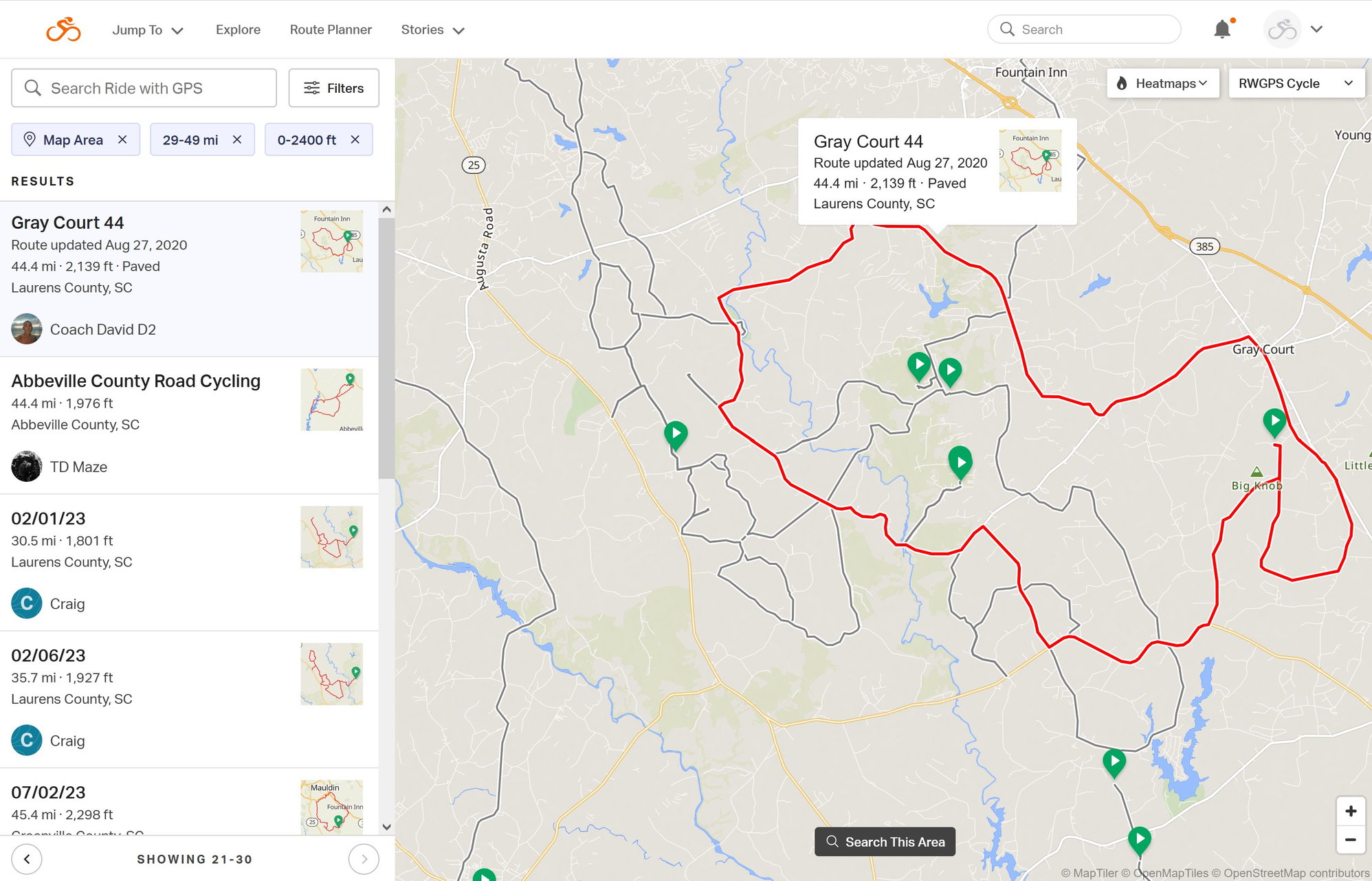
ridewithgps has a map browser, showing local routes on the map. Originally, they only searched for routes starting within X miles of a location. This newer map search finds routes on the map itself.
This search might only work with their paid version, which I have. The Basic monthly subscription might be worth it for a few months.
I have routes going back to 2011, and this map browse will show me any of my routes that includes a clicked location on the map. I use it! "what was that route we rode a few years ago that went through the scenic valley road?"
Ridewithgps Explore tab on the home page:
It shows a moveable map with 10 routes shown at a time. On the sidebar, there's a small thumbnail of each route and it's mileage and elevation.
I'm not sure how they decide which of the many local routes to show, but I have been getting emails asking to rate a ride I've done recently.
The ones I see locally usually look pretty reasonable.
Here's the map near your area. (I've never ridden there.)
The map Explore was showing some epic, long and hilly rides, so I tried out the Filters, setting 29-49 miles and 0-2400 feet. (as shown in the sidebar)
Clicking a sidebar route highlights it on the map.
The dark roads are included in at least one of the routes. Hovering over any of the roads shows a summary of that route (as shown in the screen shot.) Clicking on the road shows the popup for that route, including a link to the route page.
10-08-23, 05:17 PM
#9
20+mph Commuter
Thread Starter
Join Date: Jul 2007
Location: Greenville. SC USA
Posts: 7,517
Bikes: Surly LHT, Surly Lowside, a folding bike, and a beater.
Mentioned: 31 Post(s)
Tagged: 0 Thread(s)
Quoted: 1434 Post(s)
Liked 331 Times
in
219 Posts
Cheers.

 10-09-23, 11:55 AM
#11
For The Fun of It

Join Date: May 2007
Location: Louisissippi Coast
Posts: 5,852
Bikes: Lynskey GR300, Lynskey Backroad, Litespeed T6, Lynskey MT29, Burley Duet
Mentioned: 12 Post(s)
Tagged: 0 Thread(s)
Quoted: 2135 Post(s)
Liked 1,647 Times
in
829 Posts
I am moving to Greenville, SC early next year and had zero clues how to find "safer" bike routes. I used Google Maps, BikeMap, and others and was pulling my hair out trying to piece together some safe routes starting at my neighborhood. It is super challenging to avoid main highways due to the proliferation of cul-de-sac style developments that do not interconnect being in vogue south of the city. But FINALLY I discovered Strava Global Heatmaps and TAA-DAA, everything I could ever want.
If you look at the attached screen capture the yellow arrow points to my new location. Using other methods the areas south of me looked like barren wastelands for cycling for the most part. Google maps shows established "Bike Routes" i.e., bike paths, Rail Trails, roads with bike lanes, but no actual info on where people ACTUALLY ride bikes.
If you aren't familiar with heat maps, the brighter the color (white being the most traveled) the more trips on those routes recorded by cyclists using Strava. Every little goat-trail short cut, back alley, and otherwise "secret" short cuts are fully exposed with the heat maps. You can zoom into the images as much as you want to and there are many different visual settings to suit your preferences.
I was very happy to see a network of "farm-to-market" roads south of my neighborhood light up like Vegas! Of course I used Google Earth to look at the roads I discovered through Heat Maps. Also several "hidden away" ATB trails in or very near the city lit up bright white as well. Google Bike Maps had no clue about those either.
So if you consider meandering country roads and off-road trails and fire roads to be safer than two-lane narrow and very heavily trafficked State Highways as I do, then this tool would be most useful to you, especially if you are relatively new to an area. I was also surprised to see some of the darker colors showing that a few people even cycle the busy roads UNLESS...they just forgot to turn off Strava before driving home with the bike on the car as is obvious on the Interstate highways and toll highway where bikes are strictly forbidden.
I know this would be relevant to the Bike Touring and Commuting forums but since my main interest was pleasure rides on relatively SAFE roads I chose to post this here. Mods can move as they please.
Cheers.
https://www.strava.com/heatmap#11.00...69810/hot/ride
Thanks for sharing. That's pretty cool. It's probably worth a drive just to confirm.
Likes For Paul Barnard:
10-09-23, 03:15 PM
#12
Full Member
Join Date: Jan 2022
Location: Albuquerque NM USA
Posts: 492
Mentioned: 1 Post(s)
Tagged: 0 Thread(s)
Quoted: 222 Post(s)
Liked 304 Times
in
194 Posts
Strava heatmaps are a great way to see popular riding routes. These may or may not be safe. Though one would assume safer is more popular.
Another tool is Google street view. It gives you a great opportunity to have a look at what an area, or intersection looks like. You can also confirm if there are bike lanes and so on.
And to some degree "safe" is in the eye of the beholder.
Something I used to use a lot was Strava Flybys. Up until a few years ago you had to opt-out of this. This feature meant if you rode near another rider, or in fact saw them on a ride, you could check later and see what route they used to get where you crossed paths. I found several shortcuts and some less than obvious ways to connect between different neighborhoods this way.
Unfortunately, Strava changed Flybays to be opt-in and very few people have chosen to do that. Either by just not knowing, caring, or a concern about privacy and safety. But I wish they would make an anonymous flyby feature. I don't care who someone, just where their route went.
10-09-23, 03:37 PM
#13
20+mph Commuter
Thread Starter
Join Date: Jul 2007
Location: Greenville. SC USA
Posts: 7,517
Bikes: Surly LHT, Surly Lowside, a folding bike, and a beater.
Mentioned: 31 Post(s)
Tagged: 0 Thread(s)
Quoted: 1434 Post(s)
Liked 331 Times
in
219 Posts
So, you nailed it!
10-09-23, 03:52 PM
#14
I'm good to go!
Join Date: Jul 2017
Location: Mississippi
Posts: 14,992
Bikes: Tarmac Disc Comp Di2 - 2020
Mentioned: 51 Post(s)
Tagged: 0 Thread(s)
Quoted: 6196 Post(s)
Liked 4,811 Times
in
3,319 Posts
I went for a 42 mile ride mid day today. Except for a 2 mile portion of the MUP, all was two lane country road. None with shoulders. Had probably 100 or more cars pass me. Only one was a idiot. They felt the need to blow their horn as they passed me going up a steep hill that I'd consider a blind curve for motor vehicle speeds. Don't know whether they honked because they were annoyed or they wanted to be sure I was aware of their presence. If they only knew, I could hear them coming at least a quarter mile away.
But a very enjoyable ride. On the whole, the traffic that seemed to respect and take particular care when passing were the commercial vehicles. Particularly the dump truck. I've always wondered it the owner of that gravel company was a cyclist to. If so, maybe he's set his driver's straight on how to behave around cyclists. I don't see so many lately, but those roads use to be full of cyclist's all the time.
Anyway, I guess the gist of this or take-away for you is that you shouldn't fear the road. No one wants to run you over and ruin their day. Some won't care about you, but for sure they care about how well their day goes. And running you over won't make their day good at all. So the more you get out there, the more roads you'll find you can ride.
Not that you should ride with abandon or without caution. But I've found it's not nearly as bad as many make it out to be. Or else they just have crazies living in their area!
10-09-23, 04:28 PM
#15
20+mph Commuter
Thread Starter
Join Date: Jul 2007
Location: Greenville. SC USA
Posts: 7,517
Bikes: Surly LHT, Surly Lowside, a folding bike, and a beater.
Mentioned: 31 Post(s)
Tagged: 0 Thread(s)
Quoted: 1434 Post(s)
Liked 331 Times
in
219 Posts
I do appreciate the coaching. We all have our limits and our reasons for risk taking. I'm not quite under the bed yet, but I do keep the floor dusted under there.
Cheers!
10-11-23, 01:20 PM
#16
20+mph Commuter
Thread Starter
Join Date: Jul 2007
Location: Greenville. SC USA
Posts: 7,517
Bikes: Surly LHT, Surly Lowside, a folding bike, and a beater.
Mentioned: 31 Post(s)
Tagged: 0 Thread(s)
Quoted: 1434 Post(s)
Liked 331 Times
in
219 Posts
Here is a great example of how Strava Global Heat Maps is helping me to discover bike routes near my new house in Greenville, SC while still stuck in New Orleans, LA.
North of my house just a few miles (3-4 depending on how I do it) is a network of ATB trails. Most direct route is on Fork Shoals (Death) Road. Unless they upgrade that road, I am not riding on it. I found a potential connection (*) on Google Maps (the greyed-out segment center graphic with orange pointers) but using Google Earth it looks impassable from both sides (Photo from the North side looking South). I screen captured the spot seen below. In fact, BIKE ROUTES are turned ON in Google Maps and absolutely nothing shows up here.
Look at the heat maps image and it shows clearly that cyclists are using this cut-through somehow. Google images are YEARS OLD sometimes. Strava maps highlight only the past 12 months including just 30 days ago. Using this information keeps me off of Fork Shoals Road as well as showing me exactly where most cyclists are going here on both sides of the shortcut.
Loving it!
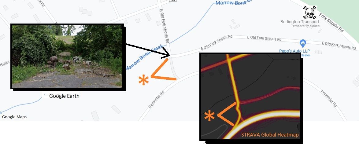
Greenville, SC shortcut
North of my house just a few miles (3-4 depending on how I do it) is a network of ATB trails. Most direct route is on Fork Shoals (Death) Road. Unless they upgrade that road, I am not riding on it. I found a potential connection (*) on Google Maps (the greyed-out segment center graphic with orange pointers) but using Google Earth it looks impassable from both sides (Photo from the North side looking South). I screen captured the spot seen below. In fact, BIKE ROUTES are turned ON in Google Maps and absolutely nothing shows up here.
Look at the heat maps image and it shows clearly that cyclists are using this cut-through somehow. Google images are YEARS OLD sometimes. Strava maps highlight only the past 12 months including just 30 days ago. Using this information keeps me off of Fork Shoals Road as well as showing me exactly where most cyclists are going here on both sides of the shortcut.
Loving it!
Greenville, SC shortcut
10-12-23, 12:09 AM
#17
Over the hill

Join Date: Mar 2006
Location: Los Angeles, CA
Posts: 24,376
Bikes: Giant Defy, Giant Revolt
Mentioned: 1 Post(s)
Tagged: 0 Thread(s)
Quoted: 998 Post(s)
Liked 1,206 Times
in
692 Posts
And if you set it to cycling, it will choose bike lanes/bike paths where possible, even sidewalk if it's allowed... or if you don't want the sidewalk, you can set it to driving mode.
__________________
It's like riding a bicycle
It's like riding a bicycle
Likes For urbanknight:
