


Accessing GAP on the north end - What route to?
 09-12-21, 10:41 AM
#1
Senior Member
Thread Starter
Join Date: Apr 2013
Posts: 1,173
Bikes: Surly Disk Trucker, 2014 w/Brooks Flyer Special saddle, Tubus racks - Duo front/Logo Evo rear, 2019 Dahon Mariner D8, Both bikes share Ortlieb Packer Plus series panniers, Garmin Edge 1000
Mentioned: 2 Post(s)
Tagged: 0 Thread(s)
Quoted: 405 Post(s)
Liked 115 Times
in
99 Posts
Accessing GAP on the north end - What route to?
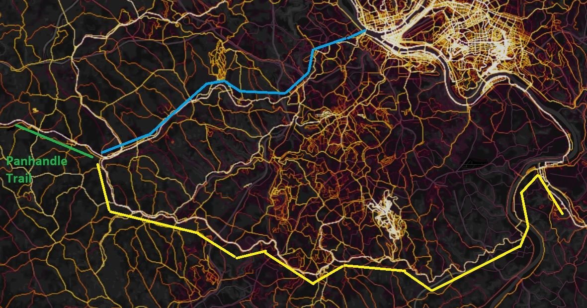
Those that have experience on the GAP around Pittsburgh - if coming from the west via connecting cycling routes - what is a better route* to the GAP?
North in to Pittsburgh to the official northern terminus - traced roughly in blue, or;
South to cross the Clairton-Glassport Bridge - traced roughly in yellow?
*As to what constitutes a "better route":
I don't have any experience with that area, from a cycling/touring perspective. I don't really have a good definition, however some ideas for basing a suggestion off of:
- History, museums, attractions, etc
- Scenery
- Elevation
- Trail conditions
- Perspective of fully self-supported touring (IE - not light/fast credit card touring)
- Safety - crime/problem areas to avoid
At first look of the route - I would be tempted to hit the northern terminus. However, the heat map shows a more traveled route down south. From experience with routing suggestions from the heat map - I can't trust what it shows on face value because the routes from another area of the country I rode in for years were road routes with a lot of traffic that bypassed and paralleled a long-distance trail route. My goal is to stick to trails/bike routes, but there is no way to easily differentiate what the heat map shows - and that is where local/first hand knowledge shines. However, one thing is for sure - if there is a "hot route" there is a reason for it. That is exactly what I am getting at with this post - those that have been on these routes - can you shed light on the reasons? And what can you offer on why to choose one or the other? Or another that I didn't highlight?
Last edited by KC8QVO; 09-12-21 at 05:02 PM. Reason: Added criteria
 09-12-21, 12:45 PM
#2
Full Member
Join Date: Feb 2015
Location: Pittsburgh, PA
Posts: 400
Bikes: Schwinn, Nishiki, Santana, Trek, Rodriguez
Mentioned: 0 Post(s)
Tagged: 0 Thread(s)
Quoted: 189 Post(s)
Likes: 0
Liked 106 Times
in
69 Posts
Both yellow and blue routes are part of the Montour Trail, for details see montourtrail.org. They are both intense on the heat map because it is a local trail that many people ride. From the Panhandle trail, you are sort of entering in the middle of the Montour trail. Which path you take depends on your interests. The south route connects more easily to the GAP. The north route brings you into downtown Pittsburgh. The connection from the end of the Montour, near Coraopolis, to the start of the GAP at the Point (an attraction, where the rivers join) is not as easy, although the signage may be better these days, don't know.
Edit: sorry, just realized that your blue route is not on the Montour, but sort of parallels it. I would stay on the Montour if you are heading for downtown.
Edit: sorry, just realized that your blue route is not on the Montour, but sort of parallels it. I would stay on the Montour if you are heading for downtown.
Likes For IPassGas:
 09-12-21, 04:21 PM
#4

Senior Member

I took the Montour Trail from McKeesport to the Panhandle Trail this summer. Other than McKeesport to Clairton, it was a very nice route.
Likes For alan s:
09-12-21, 05:01 PM
#5
Senior Member
Thread Starter
Join Date: Apr 2013
Posts: 1,173
Bikes: Surly Disk Trucker, 2014 w/Brooks Flyer Special saddle, Tubus racks - Duo front/Logo Evo rear, 2019 Dahon Mariner D8, Both bikes share Ortlieb Packer Plus series panniers, Garmin Edge 1000
Mentioned: 2 Post(s)
Tagged: 0 Thread(s)
Quoted: 405 Post(s)
Liked 115 Times
in
99 Posts
I suppose another criteria to "add to the list" (which I will edit back in after I post this) is the "safety" of the areas passed through. Are there high-crime areas to avoid? Homeless camp areas to avoid? Though, I've met (and toured with) homeless people on some of my journeys and have met some good people, just that have drawn some wrong cards in life. So I don't necessarily fear running in to homeless people, but known "problem areas" are worthy of avoiding. Sometimes that knowledge is best acquired from locals en-route for more up-to-date conditions.
09-12-21, 06:02 PM
#6
Senior Member
McKeesport to Clairton is not unsafe, just not particularly attractive in comparison and you are on roads. Coming from the GAP, it is quite industrialized and somewhat run down. I probably wouldn’t ride it at night, but during the day it was fine. Stopped at the Uni-Mart gas station at the end of the Clairton-Glassport Bridge, and the owner was kind enough to allow me to hose all the dirt off my bike from the GAP. Once past that section, the Montour Trail is really nice.
Likes For alan s:

 09-12-21, 07:00 PM
#8
Senior Member
Thread Starter
Join Date: Apr 2013
Posts: 1,173
Bikes: Surly Disk Trucker, 2014 w/Brooks Flyer Special saddle, Tubus racks - Duo front/Logo Evo rear, 2019 Dahon Mariner D8, Both bikes share Ortlieb Packer Plus series panniers, Garmin Edge 1000
Mentioned: 2 Post(s)
Tagged: 0 Thread(s)
Quoted: 405 Post(s)
Liked 115 Times
in
99 Posts
alan s What size tires do you have? Those pictures concern me. I've had problems on crushed gravel trails with my tires sinking in. I am currently running 700c x 38's. They were new last Fall when I did the Ohio to Erie. The canal trail N of Massilon was slow goin' and the section E of Dalton to about Skyland Ave was as well - soft trails and my tires sank in the muck.
I had 42's on the bike several years ago. I might be able to squeeze 45's, but no more.
I had 42's on the bike several years ago. I might be able to squeeze 45's, but no more.
09-12-21, 07:11 PM
#9
Full Member
Join Date: Feb 2015
Location: Pittsburgh, PA
Posts: 400
Bikes: Schwinn, Nishiki, Santana, Trek, Rodriguez
Mentioned: 0 Post(s)
Tagged: 0 Thread(s)
Quoted: 189 Post(s)
Likes: 0
Liked 106 Times
in
69 Posts
If you are camping, there are more possibilities on the south route. If you would like to visit the Point (an interesting place), there is one camp on the north route near Imperial. You could plan to camp there and then camp at West Newton or Cedar Creek. That would be a 50 mile day, perhaps too long, but would allow you to take in some Pittsburgh sites. If you are ok with a motel, there are "lower priced" motels on the GAP near the Waterfront store area which would be a short day and allow more time to see stuff. Bicycle Heaven is interesting, lots of old bikes and the largest collection of older Schwinn's on the planet. "Lower priced" = not as outrageous as downtown. This week appears to be particularly nice weather wise. If I had a few days off I would be heading for Confluence and further on the GAP.
Likes For IPassGas:
Likes For IPassGas:
09-12-21, 09:41 PM
#11
Senior Member
09-12-21, 09:51 PM
#12
Senior Member
alan s What size tires do you have? Those pictures concern me. I've had problems on crushed gravel trails with my tires sinking in. I am currently running 700c x 38's. They were new last Fall when I did the Ohio to Erie. The canal trail N of Massilon was slow goin' and the section E of Dalton to about Skyland Ave was as well - soft trails and my tires sank in the muck.
I had 42's on the bike several years ago. I might be able to squeeze 45's, but no more.
I had 42's on the bike several years ago. I might be able to squeeze 45's, but no more.
Likes For alan s:
09-13-21, 03:52 AM
#13
Senior Member
Join Date: Nov 2013
Location: Near Pottstown, PA: 30 miles NW of Philadelphia
Posts: 2,186
Bikes: 2 Trek Mtn, Cannondale R600 road, 6 vintage road bikes
Mentioned: 83 Post(s)
Tagged: 0 Thread(s)
Quoted: 472 Post(s)
Liked 1,028 Times
in
404 Posts
+1 When I went through, going east, I was unimpressed with soggy bottom, even though I was at the 75 mile point that day and pretty tired and saddle sore. I decided I could go "just another 10 miles". I'm so glad I did - the hiker/biker at Connelsville was a dream come true by comparison. One of the best. Keep going if you can.
09-13-21, 04:36 AM
#14
Senior Member
+1 When I went through, going east, I was unimpressed with soggy bottom, even though I was at the 75 mile point that day and pretty tired and saddle sore. I decided I could go "just another 10 miles". I'm so glad I did - the hiker/biker at Connelsville was a dream come true by comparison. One of the best. Keep going if you can.
09-13-21, 05:39 AM
#15
Senior Member
Join Date: Jan 2010
Posts: 39,239
Mentioned: 211 Post(s)
Tagged: 1 Thread(s)
Quoted: 18415 Post(s)
Liked 15,548 Times
in
7,330 Posts
Yeah. When I pulled in to Connellsville last September I was lucky to get the last available shelter. I actually thought they were all full but it turned out an itinerant drunk was just hanging out in one. He was nice enough to vacate it for me and move on.
 09-13-21, 05:45 AM
#16
Full Member
Join Date: Feb 2015
Location: Pittsburgh, PA
Posts: 400
Bikes: Schwinn, Nishiki, Santana, Trek, Rodriguez
Mentioned: 0 Post(s)
Tagged: 0 Thread(s)
Quoted: 189 Post(s)
Likes: 0
Liked 106 Times
in
69 Posts
I jest about Soggy Bottom, but it is a free place to camp with shelters, on a free and beautiful trail. Not easy for the volunteers to keep it tidy when a few unkind people leave their garbage strewn about.
