


SoCal Route Repository
 04-01-10, 10:38 AM
#1
Banned.
Thread Starter
Join Date: Sep 2007
Location: Carlsbad, CA
Posts: 6,434
Bikes: '09 Felt F55, '84 Masi Cran Criterium, (2)'86 Schwinn Pelotons, '86 Look Equippe Hinault, '09 Globe Live 3 (dogtaxi), '94 Greg Lemond, '99 GT Pulse Kinesis
Liked 270 Times
in
153 Posts
SoCal Route Repository
Please share your favorite routes & loops on this thread. Please do not post a response in here without a map of your favorite ride. If you have any questions or suggestions, please PM the individual who posted that map.
Twin Oaks - San Luis Rey - Pacific Coast Highway - Faraday Loop: 49.5 mile loop, ~3200 feet of climbing
There's a gate across Twin Oaks Parkway, but it's usually open. Even when it's closed, it's easily passed on either side. I've passed through this gate (to the right) while a resident there was working on something and he was friendly and didn't say anything about it being a private road. I've also waved to residents while riding through here and they usually waved back.

Carlsbad - Pacific Coast Highway to Mount Soledad: 50.8 mile out-&-back, with a steep mutha and a beautiful 360-degree view at the top of Mount Soledad.


Twin Oaks - San Luis Rey - Pacific Coast Highway - Faraday Loop: 49.5 mile loop, ~3200 feet of climbing
There's a gate across Twin Oaks Parkway, but it's usually open. Even when it's closed, it's easily passed on either side. I've passed through this gate (to the right) while a resident there was working on something and he was friendly and didn't say anything about it being a private road. I've also waved to residents while riding through here and they usually waved back.
Carlsbad - Pacific Coast Highway to Mount Soledad: 50.8 mile out-&-back, with a steep mutha and a beautiful 360-degree view at the top of Mount Soledad.
Last edited by calamarichris; 04-09-10 at 02:09 PM. Reason: Removed acronyms for ease of use.
 04-01-10, 10:42 AM
#2
Banned.
Thread Starter
Join Date: Sep 2007
Location: Carlsbad, CA
Posts: 6,434
Bikes: '09 Felt F55, '84 Masi Cran Criterium, (2)'86 Schwinn Pelotons, '86 Look Equippe Hinault, '09 Globe Live 3 (dogtaxi), '94 Greg Lemond, '99 GT Pulse Kinesis
Liked 270 Times
in
153 Posts
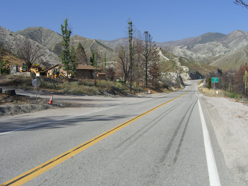
Flattish Century from Carlsbad to South Laguna Beach, via Camp Pendleton: ~99 mile out-&-back, ~3400 feet of climbage (beware the afternoon cross-wind.) Bring your driver's license to get past the Pendleton gate guards and please obey the traffic laws and signs advising cyclists to ride single-file through Pendleton. It's a great route, but if enough of us civilian cyclists behave badly riding through there, the post commanding general can simply deny us access. (Pendleton is a military installation and is therefore NOT a public road.)
Last edited by calamarichris; 04-09-10 at 03:48 PM.
04-01-10, 10:48 AM
#3
Banned.
Thread Starter
Join Date: Sep 2007
Location: Carlsbad, CA
Posts: 6,434
Bikes: '09 Felt F55, '84 Masi Cran Criterium, (2)'86 Schwinn Pelotons, '86 Look Equippe Hinault, '09 Globe Live 3 (dogtaxi), '94 Greg Lemond, '99 GT Pulse Kinesis
Liked 270 Times
in
153 Posts
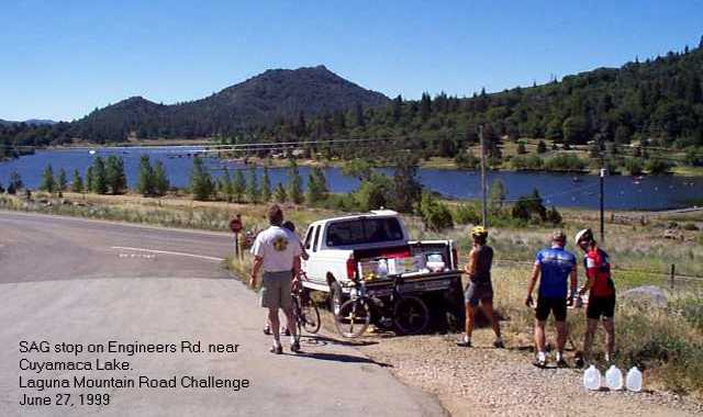
Pine Valley - Cuyamaca Lake - Sunrise Highway Loop - 49.1 mile loop, >4000 feet climbage

And here's a cool write-up with excellent photos by a fellow cyclist named Kirby James who calls it The Laguna Triangle. (Click)
And here's a cool write-up with excellent photos by a fellow cyclist named Kirby James who calls it The Laguna Triangle. (Click)
Last edited by calamarichris; 04-09-10 at 02:17 PM.
 04-01-10, 12:16 PM
#5
Banned.
Thread Starter
Join Date: Sep 2007
Location: Carlsbad, CA
Posts: 6,434
Bikes: '09 Felt F55, '84 Masi Cran Criterium, (2)'86 Schwinn Pelotons, '86 Look Equippe Hinault, '09 Globe Live 3 (dogtaxi), '94 Greg Lemond, '99 GT Pulse Kinesis
Liked 270 Times
in
153 Posts
Twin Oaks - Circle R - West Lilac - Couser Canyon - San Luis Rey - Pacific Coast Highway: 65.7 mile loop with 5125 feet of climbage.
Riding on the 78 west of the $%^% Pala Casino is no longer suicidal, since they've widened and smoothed it. There's also a nice little produce stand that sells water right there on Pala Road.
West Lilac & Couser Canyon are a must-see for any cyclist IMO.


Riding on the 78 west of the $%^% Pala Casino is no longer suicidal, since they've widened and smoothed it. There's also a nice little produce stand that sells water right there on Pala Road.
West Lilac & Couser Canyon are a must-see for any cyclist IMO.
Last edited by calamarichris; 04-05-10 at 10:53 AM. Reason: Added climbage after 4/2/10 ride
04-01-10, 12:38 PM
#6
Banned.
Thread Starter
Join Date: Sep 2007
Location: Carlsbad, CA
Posts: 6,434
Bikes: '09 Felt F55, '84 Masi Cran Criterium, (2)'86 Schwinn Pelotons, '86 Look Equippe Hinault, '09 Globe Live 3 (dogtaxi), '94 Greg Lemond, '99 GT Pulse Kinesis
Liked 270 Times
in
153 Posts
Elfin Forest - Del Dios - Rancho Santa Fe - Pacific Coast Highway Loop: 41.4 miles of rolling hills. Exact climbage to be announced (on all these routes). Del Dios Highway is a major thoroughfare, but it has a wide shoulder and has recently been improved.
(From Del Dios Highway you can see Lake Hodges Dam to the South.)

And it turns out this is also known as "The Swami's Ride" leaving every Saturday morning at 8:10 from Nytro in Leucadia. (Click.)
(From Del Dios Highway you can see Lake Hodges Dam to the South.)
And it turns out this is also known as "The Swami's Ride" leaving every Saturday morning at 8:10 from Nytro in Leucadia. (Click.)
Last edited by calamarichris; 04-09-10 at 03:42 PM.
04-09-10, 10:35 AM
#7
Banned.
Thread Starter
Join Date: Sep 2007
Location: Carlsbad, CA
Posts: 6,434
Bikes: '09 Felt F55, '84 Masi Cran Criterium, (2)'86 Schwinn Pelotons, '86 Look Equippe Hinault, '09 Globe Live 3 (dogtaxi), '94 Greg Lemond, '99 GT Pulse Kinesis
Liked 270 Times
in
153 Posts
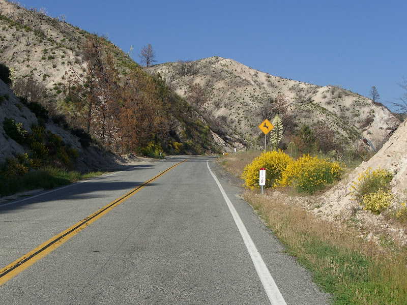
Wynola - Julian - Cuyamaca & Return - This 40-mile out-n-back doesn't have many flat sections, and the road is too narrow to be divided, but the asphalt quality is remarkable good for such a lightly-traveled road.
This area was flattened by a fire about five years ago, so the oak-canopy over the road is gone. But the new growth is really beautiful and you'll see a few burnt trees sprouting back to life again.
Be sure to bring at least a 39-25 on this one, because there are a few crazy-steep sections. Also, this is more of a site-seeing ride than a steady workout--the road has lots of up & down, so your heartrate will likely be spiking and diving accordingly. There are markets with water & snacks at Wynola, Julian and the south shore of Lake Cuyamaca.
If you find yourself running out of daylight, you can jet back to Wynola on the 79 & 78, but the traffic will seem terrible after the quiet serenity of Engineers Road.
Last edited by calamarichris; 04-09-10 at 04:06 PM.
04-09-10, 03:06 PM
#8
Banned.
Thread Starter
Join Date: Sep 2007
Location: Carlsbad, CA
Posts: 6,434
Bikes: '09 Felt F55, '84 Masi Cran Criterium, (2)'86 Schwinn Pelotons, '86 Look Equippe Hinault, '09 Globe Live 3 (dogtaxi), '94 Greg Lemond, '99 GT Pulse Kinesis
Liked 270 Times
in
153 Posts
PIE Ride: Escondido - Palomar - Mesa Grande - Santa Ysabel - Highland Valley Loop. This 87.5 mile loop is tough with almost 8,000 feet of climbing, but with plenty of great scenery, especially on Palomar Mountain, Mesa Grande and Old Julian Road, which runs parallel to the 78 and has recently been resurfaced. There are convenience stores located at the green destination points. Valley Center Road along the Harrah's casino is pretty bad asphalt, but it's mostly downhill. The Stage Stop Market is a conveniently placed market, but they are not friendly to cyclists, (apparently because some of us take up their parking spaces when climbing Palomar?)
And here is an alternate Pie Route, which adds a few miles (totaling 90.4 miles), but avoids the narrow section of Lake Wohlford Road (which some folks don't care for), and the nasty, rough, and awful Casino Alley portion of Valley Center Rd., which is pretty rough.
Watch for the camel farm on the right of Old Julian Road.
Last edited by calamarichris; 04-09-10 at 03:30 PM.
04-09-10, 07:41 PM
#9

Over the hill

Join Date: Mar 2006
Location: Los Angeles, CA
Posts: 24,418
Bikes: Giant Defy, Giant Revolt
Liked 1,259 Times
in
714 Posts
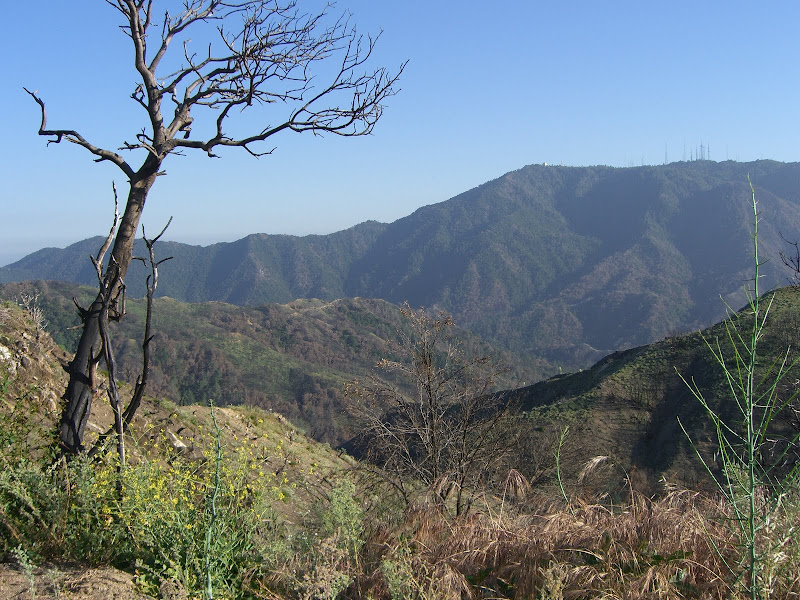
Angeles Crest to Grassy Hollow (Angeles Forest)
Out-and-Back century with about 12,000' of climbing (nothing super steep, but you're almost always climbing or descending). Plenty of beautiful mountain views and high peaks that take your breath away (both from the thin air and from the views). Water spigots at Clear Creek (about mile 8/95), Red Box (about mile 13/90), and Grassy Hollow (at the turnaround campground), and a restaurant called Newcomb's Ranch at about mile 25/78.
Lake Sherwood Loop (Agoura/Thousand Oaks)
A quick 35 mile route through a little known but beautiful valley near Los Angeles/Ventura county border. A few moderate climbs on the way out and somewhat busy roads on the return portion, but this was one of my favorite routes as a teen.
Mt Baldy via East Fork and down Glendora Mountain Road (San Gabriel Mountains)
63 miles with plenty of sustained climbing that leads to the town of Baldy with the option of adding 4 brutally steep miles to get to the ski area above it, and 4 hands-on-the-brakes miles back down. Beautiful resevoir and mountain views. The descent down GMR is technical, with decreasing radius blind curves, so know your limits.
Upper Big Tujunga (Pasadena/Angeles Forest)
60 miles (if you start from the Rose Bowl instead of my house) with sustained climbs and fun descents. Not to most scenic, but a challenging route. There is no water after Red Box until you come back down the mountain, and Upper Big T can get very hot compared to its neighboring canyons.
Latigo and Piuma (Malibu/Calabasas)
A nice 52 mile climbing ride in the Santa Monicas. It starts with a nice warm-up along the PCH before tackling the most challenging climb (Latigo) before descending the famous "Rock Store" (watch for motorcycles, especially on Sundays) and heading over to climb Piuma. Beautiful ocean views and a fun descent down Tuna Canyon before wrapping it all up.
__________________
It's like riding a bicycle
It's like riding a bicycle
04-12-10, 04:21 PM
#10
Banned.
Thread Starter
Join Date: Sep 2007
Location: Carlsbad, CA
Posts: 6,434
Bikes: '09 Felt F55, '84 Masi Cran Criterium, (2)'86 Schwinn Pelotons, '86 Look Equippe Hinault, '09 Globe Live 3 (dogtaxi), '94 Greg Lemond, '99 GT Pulse Kinesis
Liked 270 Times
in
153 Posts
San Elijo to Packard's Coffee in Ramona - this 64-mile out&back is loads of fun and usually doesn't have much traffic. There's plenty of parking behind Isabelle Brien's Coffee Shop in San Elijo, and a grassy square to stretch out when you return.
This route makes good use of the Oak Canopy Effect and takes you over the new Hodges Pedestrian/Cyclist Bridge.
Armstrong et al on Highland Valley Road in '09:

Packard's Coffee on Main Street in Ramona:

This route makes good use of the Oak Canopy Effect and takes you over the new Hodges Pedestrian/Cyclist Bridge.
Armstrong et al on Highland Valley Road in '09:
Packard's Coffee on Main Street in Ramona:
Last edited by calamarichris; 01-14-11 at 04:01 PM.
04-15-10, 02:44 AM
#11
Senior Member
Join Date: Aug 2007
Location: Belmont Shore (Long Beach), CA
Posts: 508
Bikes: Scattante R-560 w/ Velocity Deep V rims
Likes: 0
Liked 0 Times
in
0 Posts
First, excellent idea for a thread.
Silverado Canyon
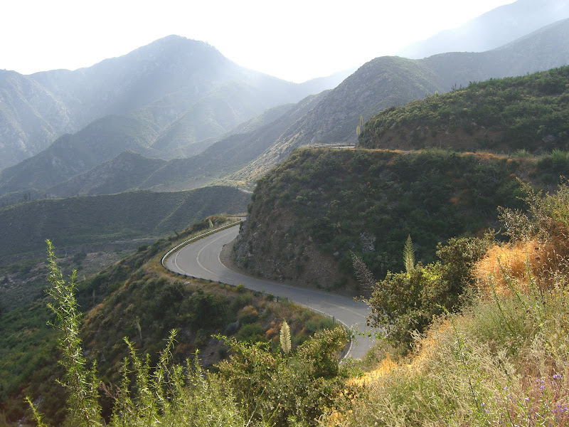
This canyon climb is a great low traffic, out and back climb. The warm up is along Santiago Canyon Road - while it has a fair amount of high speed traffic it is also rather scenic:
After the warm up, you turn right onto Silverado Canyon Road. The first half is a gentle grade that goes through the town of Silverado:
The last half is a gorgeous, increasingly steeper section that is often closed to cars (this is the Maple Springs Trailhead section):
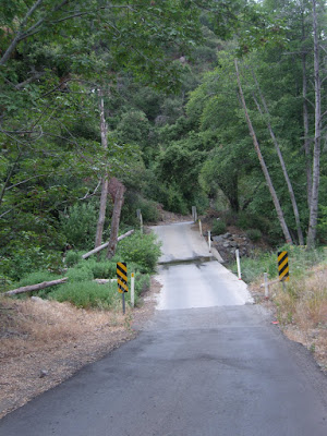
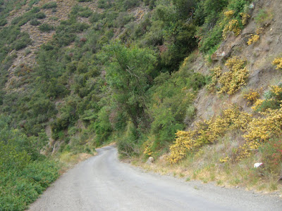
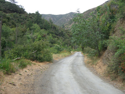
Overall, the climb gives you a bit over 2000 feet of elevation gain (in addition to what you climbed on Santiago Canyon Rd). The Maple Springs section gives you 3 miles of 7%+ climbing.
The route map can be found here: https://www.mapmyride.com/view_route?...1&rs=undefined.
My ride report, with more pictures, commentary and maps can be found here: https://www.toughascent.com/blog/?p=45.
Silverado Canyon
This canyon climb is a great low traffic, out and back climb. The warm up is along Santiago Canyon Road - while it has a fair amount of high speed traffic it is also rather scenic:
After the warm up, you turn right onto Silverado Canyon Road. The first half is a gentle grade that goes through the town of Silverado:
The last half is a gorgeous, increasingly steeper section that is often closed to cars (this is the Maple Springs Trailhead section):
Overall, the climb gives you a bit over 2000 feet of elevation gain (in addition to what you climbed on Santiago Canyon Rd). The Maple Springs section gives you 3 miles of 7%+ climbing.
The route map can be found here: https://www.mapmyride.com/view_route?...1&rs=undefined.
My ride report, with more pictures, commentary and maps can be found here: https://www.toughascent.com/blog/?p=45.
06-14-10, 08:50 AM
#12
Senior Member
Join Date: Aug 2007
Location: Belmont Shore (Long Beach), CA
Posts: 508
Bikes: Scattante R-560 w/ Velocity Deep V rims
Likes: 0
Liked 0 Times
in
0 Posts
Reviving this thread..
CA-39 to Dawson Saddle
22.5 miles long (parking near West Fork)
Starting elevation: 1600 ft
Ending elevation: 7901 ft
Elevation gain: 6300 ft
5.3% average grade (5.6% for the 39 section)
My ride report can be found here: https://www.toughascent.com/blog/?p=152.
CA-39 to Dawson Saddle
22.5 miles long (parking near West Fork)
Starting elevation: 1600 ft
Ending elevation: 7901 ft
Elevation gain: 6300 ft
5.3% average grade (5.6% for the 39 section)
My ride report can be found here: https://www.toughascent.com/blog/?p=152.
Last edited by rallison; 06-17-10 at 01:18 AM.
06-17-10, 01:11 AM
#13
Senior Member
Join Date: Aug 2007
Location: Belmont Shore (Long Beach), CA
Posts: 508
Bikes: Scattante R-560 w/ Velocity Deep V rims
Likes: 0
Liked 0 Times
in
0 Posts
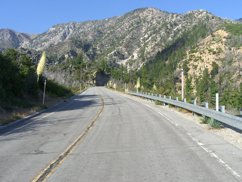
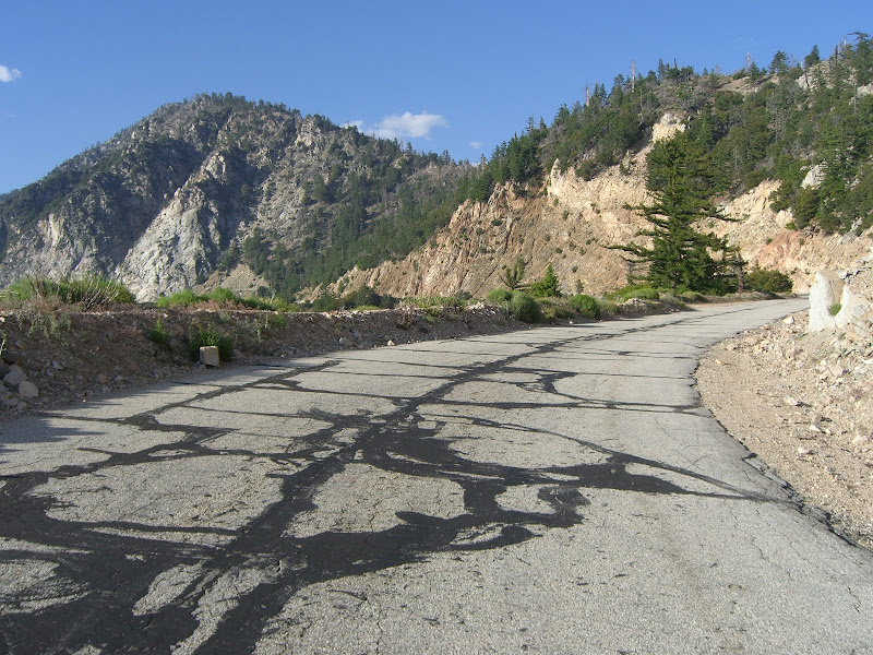
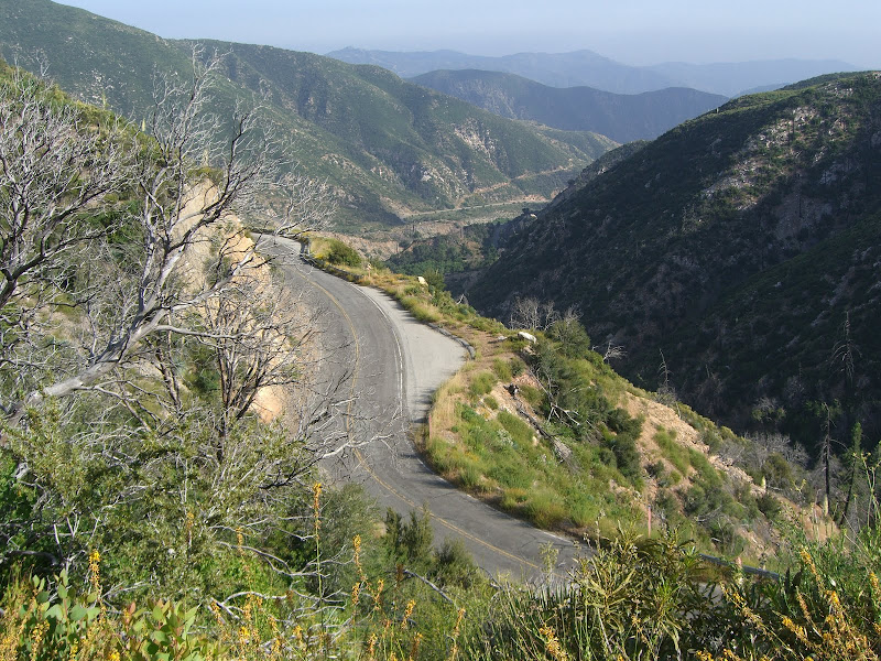
Upper Big Tujunga (Pasadena/Angeles Forest)
60 miles (if you start from the Rose Bowl instead of my house) with sustained climbs and fun descents. Not to most scenic, but a challenging route. There is no water after Red Box until you come back down the mountain, and Upper Big T can get very hot compared to its neighboring canyons.
60 miles (if you start from the Rose Bowl instead of my house) with sustained climbs and fun descents. Not to most scenic, but a challenging route. There is no water after Red Box until you come back down the mountain, and Upper Big T can get very hot compared to its neighboring canyons.
With that said, a few pictures from along Big Tujunga, Angeles Forest Hwy and Upper Big Tujunga:
Big Tujunga:
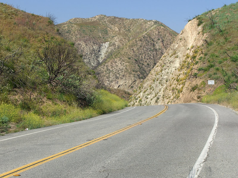
Angeles Forest Hwy Panorama:
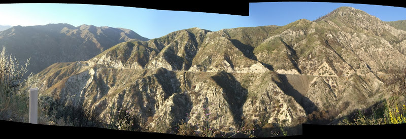
Angeles Forest Hwy:
Upper Big Tujunga:
Intersection with Angeles Crest Hwy looking at Mt. Wilson:
Note that there almost this entire section is fire damaged. The photos above are also of the more scenic sections. Overall, i found the scenery quite disappointing after having just climbed 39. This will improve in the next few years as more plant life returns, of course. Also, as mentioned, it does get hot in these canyons. Big Tujunga, especially - lots of rock walls against the road that the sun beats down upon.
Last edited by rallison; 06-17-10 at 01:16 AM.
12-21-10, 12:56 PM
#14


Fresh Garbage
 12-21-10, 04:29 PM
#15
Banned.
Thread Starter
Join Date: Sep 2007
Location: Carlsbad, CA
Posts: 6,434
Bikes: '09 Felt F55, '84 Masi Cran Criterium, (2)'86 Schwinn Pelotons, '86 Look Equippe Hinault, '09 Globe Live 3 (dogtaxi), '94 Greg Lemond, '99 GT Pulse Kinesis
Liked 270 Times
in
153 Posts
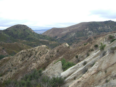
San Luis Obispo to Morro Rock to Avila Beach via Prefumo Canyon, return to SLO via the wonderful (but unfinished) Bob Jones MUP (partially at least.)
SLO is such a great, great town for bicycles! (And for wine, and for beer, and for pretty young girls.) Be sure to stop by one of their bike shops and ask for the free bike-touristy maps provided by the SLO Chamber of Commerce. When complete, the Bob Jones Trail is supposed to be a MUP straight from downtown SLO to the coast. It's excellent quality asphalt and top-notch scenery. Don't expect much sunshine in Morro Bay, but there are all kinds of touristy shops, cafes, restaurants and kayak rentals!
Prefumo Canyon has some steep, but strikingly gorgeous sections. (Clicky for road view.)
After a brief dirt section, which is easily traversed when dry, even on 700x23 tires, it becomes See Canyon Road, which passes a bunch of neat apple orchards on the descent to Avila Beach.

Morro Bay during a rare moment of sunshine.


Prefumo Canyon Road is gorgeous, but I won't be going that way again without at least a 39-27.

After a brief dirt section, Prefumo turns downhill to See Canyon Road. Look for the apple orchards on your left.

More apples than leaves in early December!

From Avila Beach, you can take Avila Beach Road west to the dead end at Port San Luis.

And when complete, the lovely Bob Jones Trail will connect SLO with the coast. Bellissima!
Click here for more photos & info on the Bob Jones Trail.

And this photo is from an old '05 trip, but the Fremont Theater's markee is typical of downtown SLO.
SLO is such a great, great town for bicycles! (And for wine, and for beer, and for pretty young girls.) Be sure to stop by one of their bike shops and ask for the free bike-touristy maps provided by the SLO Chamber of Commerce. When complete, the Bob Jones Trail is supposed to be a MUP straight from downtown SLO to the coast. It's excellent quality asphalt and top-notch scenery. Don't expect much sunshine in Morro Bay, but there are all kinds of touristy shops, cafes, restaurants and kayak rentals!
Prefumo Canyon has some steep, but strikingly gorgeous sections. (Clicky for road view.)
After a brief dirt section, which is easily traversed when dry, even on 700x23 tires, it becomes See Canyon Road, which passes a bunch of neat apple orchards on the descent to Avila Beach.
Morro Bay during a rare moment of sunshine.
Prefumo Canyon Road is gorgeous, but I won't be going that way again without at least a 39-27.
After a brief dirt section, Prefumo turns downhill to See Canyon Road. Look for the apple orchards on your left.
More apples than leaves in early December!
From Avila Beach, you can take Avila Beach Road west to the dead end at Port San Luis.
And when complete, the lovely Bob Jones Trail will connect SLO with the coast. Bellissima!
Click here for more photos & info on the Bob Jones Trail.
And this photo is from an old '05 trip, but the Fremont Theater's markee is typical of downtown SLO.
Last edited by calamarichris; 12-21-10 at 05:58 PM.
10-30-15, 09:42 AM
#17
Shredding Grandma!

Join Date: Jun 2006
Location: So Cal
Posts: 4,803
Bikes: I don't own any bikes
Likes: 0
Liked 1 Time
in
1 Post
Just edited to add... the Maple Springs section of this route was closed last year (due to fire) and close until next September 2016 due to concern over flooding.
__________________
 ______________________________________________________________
Private docent led mountain bike rides through Limestone Canyon. Go to letsgooutside.org and register today! Also available: hikes, equestrian rides and family events as well as trail maintenance and science study.
______________________________________________________________Private docent led mountain bike rides through Limestone Canyon. Go to letsgooutside.org and register today! Also available: hikes, equestrian rides and family events as well as trail maintenance and science study.
06-15-17, 03:45 PM
#19
Pedo Grande

Join Date: Jul 2008
Location: San Diego
Posts: 872
Bikes: Cervelo C3, Serotta Legend Ti, Vitus 979
Likes: 0
Liked 0 Times
in
0 Posts
Great Western Loop - 40+ mi loop ~ 3000' of climbing
A favorite among many in San Diego county. Nice two lane back country roads, punctuated by some good climbs and fun descents, plus the views aren't bad either. it gets hot out there during the summer months so make sure to bring plenty of water.
GWL in El Cajon, CA, United States | MapMyRide
A favorite among many in San Diego county. Nice two lane back country roads, punctuated by some good climbs and fun descents, plus the views aren't bad either. it gets hot out there during the summer months so make sure to bring plenty of water.
GWL in El Cajon, CA, United States | MapMyRide
02-26-18, 02:32 PM
#20
SuperGimp

I'll add one of my favorite one-way routes. The general idea is that you park at a metrolink station and return via metrolink, so this is a one-way trip from Anaheim / Corona (or Riverside if you're extra motivated).
The hillier route: https://ridewithgps.com/routes/15777777 (83 miles, 4300 feet, 8 miles on I-5 to bypass the marine base, features Imperial/Cannon, Santiago Canyon, Modjeska and Live Oak for the climby bits)
The flatter variant: https://ridewithgps.com/routes/14476152 (81 miles, 2800 feet, this route also goes through the marine base - feel free to mix and match, a variety of OC bike paths on this route)
There are a bunch of restaurants and places to eat in the general area near the metrolink station in Oceanside. Check the schedules but the weekend train pass is $10 for all day and the Riverside train departs O-side at 2:50 and there is usually a later option as well.
Likes For TrojanHorse:
02-26-18, 03:03 PM
#21
Senior Member
I'll add one of my favorite one-way routes. The general idea is that you park at a metrolink station and return via metrolink, so this is a one-way trip from Anaheim / Corona (or Riverside if you're extra motivated).
The hillier route: https://ridewithgps.com/routes/15777777 (83 miles, 4300 feet, 8 miles on I-5 to bypass the marine base, features Imperial/Cannon, Santiago Canyon, Modjeska and Live Oak for the climby bits)
The flatter variant: https://ridewithgps.com/routes/14476152 (81 miles, 2800 feet, this route also goes through the marine base - feel free to mix and match, a variety of OC bike paths on this route)
There are a bunch of restaurants and places to eat in the general area near the metrolink station in Oceanside. Check the schedules but the weekend train pass is $10 for all day and the Riverside train departs O-side at 2:50 and there is usually a later option as well.
The hillier route: https://ridewithgps.com/routes/15777777 (83 miles, 4300 feet, 8 miles on I-5 to bypass the marine base, features Imperial/Cannon, Santiago Canyon, Modjeska and Live Oak for the climby bits)
The flatter variant: https://ridewithgps.com/routes/14476152 (81 miles, 2800 feet, this route also goes through the marine base - feel free to mix and match, a variety of OC bike paths on this route)
There are a bunch of restaurants and places to eat in the general area near the metrolink station in Oceanside. Check the schedules but the weekend train pass is $10 for all day and the Riverside train departs O-side at 2:50 and there is usually a later option as well.
https://www.metrolinktrains.com/train-status/

Thread
Thread Starter
Forum
Replies
Last Post
Seattle Forrest
Pacific Northwest
5
04-23-12 09:22 AM
Velo Vol
Road Cycling
27
10-14-10 03:54 PM
