Mi: Sterling/Red Run Drain Pathway
 10-29-21, 02:40 PM
#1
Full Member
Thread Starter

Mi: Sterling/Red Run Drain Pathway
Just found out about this. Get the word out!!! As a previously proposed portion(*western most) of the same pathway was squashed by NIMBYs because the bicycling community wasn't made aware of the project.
Macomb County Department of Roads has requested that the Red Run Intercounty Drain Drainage District construct the 1.35 mile waterfront trail portion of the Grant Work
(�Waterfront Trail�) as part of the Project. The Waterfront Trail consists of a ten-foot-wide,aggregate trail, commencing at Schoenherr Road, and following at the north bank of the Sterling Relief Drain, then following the north bank of the Red Run Intercounty Drain, terminating at Metropolitan Parkway
Intercounty Drain Drainage District meeting minutes March 17,2021
https://www.oakgov.com/water/resourc...a%20packet.pdf
*Initially the pathway was to begin at Nelson Park about 5 miles west of Schoenherr
 10-30-21, 05:27 AM
#2

Senior Member
Join Date: Oct 2013
Location: Mich
Posts: 7,395
Bikes: RSO E-tire dropper fixie brifter
Mentioned: 0 Post(s)
Tagged: 0 Thread(s)
Quoted: 6 Post(s)
Liked 2,979 Times
in
1,920 Posts
Just found out about this. Get the word out!!! As a previously proposed portion(*western most) of the same pathway was squashed by NIMBYs because the bicycling community wasn't made aware of the project.
Macomb County Department of Roads has requested that the Red Run Intercounty Drain Drainage District construct the 1.35 mile waterfront trail portion of the Grant Work
(�Waterfront Trail�) as part of the Project. The Waterfront Trail consists of a ten-foot-wide,aggregate trail, commencing at Schoenherr Road, and following at the north bank of the Sterling Relief Drain, then following the north bank of the Red Run Intercounty Drain, terminating at Metropolitan Parkway
Intercounty Drain Drainage District meeting minutes March 17,2021
https://www.oakgov.com/water/resourc...a%20packet.pdf
*Initially the pathway was to begin at Nelson Park about 5 miles west of Schoenherr
Macomb County Department of Roads has requested that the Red Run Intercounty Drain Drainage District construct the 1.35 mile waterfront trail portion of the Grant Work
(�Waterfront Trail�) as part of the Project. The Waterfront Trail consists of a ten-foot-wide,aggregate trail, commencing at Schoenherr Road, and following at the north bank of the Sterling Relief Drain, then following the north bank of the Red Run Intercounty Drain, terminating at Metropolitan Parkway
Intercounty Drain Drainage District meeting minutes March 17,2021
https://www.oakgov.com/water/resourc...a%20packet.pdf
*Initially the pathway was to begin at Nelson Park about 5 miles west of Schoenherr
If it were expanded to the additional distance as previously planned; that [IMO] would reduce a lot of safety risks for those that go from the most eastern [Amphitheatre] side of the drain over to Halmich Park.
The distance is better than nothing, but it should ideally connect back into the northern metro ped area or continue where it can meet to a lower vehicle MPH & traffic density area (Martin/Common). I get why aggregate is being used, however, that is another 1/2 stepping logic for [again; IMO] ped use.
What I will never accept at this point from this state is the lack of continuity for trail/pathway projects. If the pathways are paved wide, well kept {IE: flooding, holes, cracks & bumps addressed in a timely manner} & routed to avoid interfering with motorized traffic, then the road rage is greatly reduced which will naturally promote ped safety & be more likely used... but hey, I am no politician & have no seat in the decision making with the tax payers money. Much rather see open space with no roads be purposed for non-motorized traffic rather than roads marked with "Bike Lane".
I looked at the PDF. & didn't see an image to outline the proposed route plan. That would be something to add into the PDF. to help understand what is [again; IMO] being put in place.
__________________
-Oh Hey!
-Oh Hey!
10-30-21, 08:05 PM
#3
Full Member
Thread Starter
Here's what the original plan looked like. Must believe that nothing has changed ,other than the only portion being constructed is east of Schoenner.
https://gis.macombgov.org/appsdev/St...f/Overview.pdf
Likes For detroitjim:
10-31-21, 01:58 PM
#4
Senior Member
Join Date: Oct 2013
Location: Mich
Posts: 7,395
Bikes: RSO E-tire dropper fixie brifter
Mentioned: 0 Post(s)
Tagged: 0 Thread(s)
Quoted: 6 Post(s)
Liked 2,979 Times
in
1,920 Posts
Here's what the original plan looked like. Must believe that nothing has changed ,other than the only portion being constructed is east of Schoenner.
https://gis.macombgov.org/appsdev/St...f/Overview.pdf
https://gis.macombgov.org/appsdev/St...f/Overview.pdf
__________________
-Oh Hey!
-Oh Hey!
01-09-22, 10:27 PM
#5
Full Member
Thread Starter
One of the local fish wraps just broke the story!
Maybe the propagation delay is a good thing. Decision made ,funds appropriated before the anti's can stop it.
https://www.macombdaily.com/2022/01/...l-county-park/
Maybe the propagation delay is a good thing. Decision made ,funds appropriated before the anti's can stop it.
https://www.macombdaily.com/2022/01/...l-county-park/
Last edited by detroitjim; 01-16-22 at 12:48 PM.
Likes For detroitjim:
11-02-22, 07:11 PM
#6
Full Member
Thread Starter
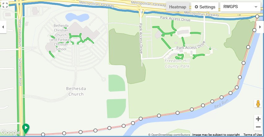
Macomb county officials show up to announce the opening of this new Sterling heights trail.
https://www.macombdaily.com/2022/11/...rling-heights/
Now they need to continue this path westward to Nelson park (between Ryan and Dequindre)along the Sterling drain.
Originally known as a linear park project , the SH council and Macomb leaders caved to the NIMBY's and cancelled it a few years ago.
11-03-22, 09:32 AM
#7
Senior Member
Join Date: Oct 2013
Location: Mich
Posts: 7,395
Bikes: RSO E-tire dropper fixie brifter
Mentioned: 0 Post(s)
Tagged: 0 Thread(s)
Quoted: 6 Post(s)
Liked 2,979 Times
in
1,920 Posts
be careful if your ride on it, it's rather "loose" & can potentially end up in the drink.
__________________
-Oh Hey!
-Oh Hey!
10-23-23, 07:12 PM
#8
Sunshine

Join Date: Aug 2014
Location: Des Moines, IA
Posts: 16,614
Bikes: '18 class built steel roadbike, '19 Fairlight Secan, '88 Schwinn Premis , Black Mountain Cycles Monstercross V4, '89 Novara Trionfo
Mentioned: 123 Post(s)
Tagged: 0 Thread(s)
Quoted: 10965 Post(s)
Liked 7,492 Times
in
4,189 Posts