


View Poll Results: Do you like to review the route prior to your ride?
Yes, it helps me decide if it's something I'd feel comfortable riding.


30
78.95%
No, I just show up and hope Mt Everest isn't on the route.


8
21.05%
Voters: 38. You may not vote on this poll
Review the route before you ride?
 03-19-21, 06:56 AM
#26
Senior Member

Join Date: May 2020
Location: Great White North
Posts: 1,226
Bikes: 2013 Cannondale Caad 8, 2010 Opus Fidelio, 1985 Peugeot UO14, 1999 Peugeot Dune, Sakai Select, L'Avantage, 1971 Gitane Apache Standard, 1999 Specialized Hard Rock
Mentioned: 10 Post(s)
Tagged: 0 Thread(s)
Quoted: 548 Post(s)
Liked 473 Times
in
302 Posts
 03-19-21, 10:16 AM
#27

Have bike, will travel

Join Date: Feb 2006
Location: Lake Geneva, WI
Posts: 12,284
Bikes: Ridley Helium SLX, Canyon Endurance SL, De Rosa Professional, Eddy Merckx Corsa Extra, Schwinn Paramount (1 painted, 1 chrome), Peugeot PX10, Serotta Nova X, Simoncini Cyclocross Special, Raleigh Roker, Pedal Force CG2 and CX2
Mentioned: 46 Post(s)
Tagged: 0 Thread(s)
Quoted: 910 Post(s)
Liked 288 Times
in
158 Posts
I've used Map-my-Ride to help find routes is rural Italy, with excellent results;
: https://www.mapmyride.com/routes/view/409214538
: https://www.mapmyride.com/routes/view/409214538

__________________
When I ride my bike I feel free and happy and strong. I'm liberated from the usual nonsense of day to day life. Solid, dependable, silent, my bike is my horse, my fighter jet, my island, my friend. Together we will conquer that hill and thereafter the world.
When I ride my bike I feel free and happy and strong. I'm liberated from the usual nonsense of day to day life. Solid, dependable, silent, my bike is my horse, my fighter jet, my island, my friend. Together we will conquer that hill and thereafter the world.
Last edited by Barrettscv; 03-19-21 at 10:45 AM.
03-26-21, 01:58 AM
#28
In Real Life

Join Date: Jan 2003
Location: Down under down under
Posts: 52,152
Bikes: Lots
Mentioned: 141 Post(s)
Tagged: 0 Thread(s)
Quoted: 3203 Post(s)
Liked 596 Times
in
329 Posts
Try riding in Tasmania! It's hard to avoid the steep hills here.
__________________
Rowan
My fave photo threads on BF
Century A Month Facebook Group
Machka's Website
Photo Gallery
Rowan
My fave photo threads on BF
Century A Month Facebook Group
Machka's Website
Photo Gallery
03-26-21, 02:05 AM
#29
In Real Life
Join Date: Jan 2003
Location: Down under down under
Posts: 52,152
Bikes: Lots
Mentioned: 141 Post(s)
Tagged: 0 Thread(s)
Quoted: 3203 Post(s)
Liked 596 Times
in
329 Posts
Prior to moving to Tasmania, I used to just go!
Since moving to Tasmania, I check the routes because it is way too easy to end up on some immense climb and/or narrow gravel road.
Since Rowan's accident, we prefer quiet roads, relatively flat roads, and usually sealed or packed/smooth gravel.
Since moving to Tasmania, I check the routes because it is way too easy to end up on some immense climb and/or narrow gravel road.
Since Rowan's accident, we prefer quiet roads, relatively flat roads, and usually sealed or packed/smooth gravel.
__________________
Rowan
My fave photo threads on BF
Century A Month Facebook Group
Machka's Website
Photo Gallery
Rowan
My fave photo threads on BF
Century A Month Facebook Group
Machka's Website
Photo Gallery
03-26-21, 02:18 AM
#30
velo-dilettante
Join Date: Apr 2009
Location: insane diego, california
Posts: 8,336
Bikes: 85 pinarello treviso steel, 88 nishiki olympic steel. 95 look kg 131 carbon, 11 trek madone 5.2 carbon
Mentioned: 26 Post(s)
Tagged: 0 Thread(s)
Quoted: 1630 Post(s)
Liked 3,128 Times
in
1,692 Posts
usually a little bit, yes, for the highlights and such, but prefer to keep a little mystery involved. often, more concerned with support than route climbing difficulties.
03-26-21, 02:21 AM
#31
velo-dilettante
Join Date: Apr 2009
Location: insane diego, california
Posts: 8,336
Bikes: 85 pinarello treviso steel, 88 nishiki olympic steel. 95 look kg 131 carbon, 11 trek madone 5.2 carbon
Mentioned: 26 Post(s)
Tagged: 0 Thread(s)
Quoted: 1630 Post(s)
Liked 3,128 Times
in
1,692 Posts
My wife and I decided to take a drive to check out a posted ride not too far away from our home. Thankfully we did this before riding as it was one of the most flipping dangerous routes I�ve ever seen. We did encounter a few cyclists who clearly didn�t see it that way but to each their own.
It�s not always possible to drive them out but we try to if we can.
It�s not always possible to drive them out but we try to if we can.
Likes For diphthong:
03-26-21, 09:26 AM
#32
Senior Member
Join Date: Sep 2005
Location: In the foothills of Los Angeles County
Posts: 25,333
Mentioned: 8 Post(s)
Tagged: 0 Thread(s)
Quoted: 8310 Post(s)
Liked 9,103 Times
in
4,499 Posts
I'm sure there are steep hills there, but would a charity ride send riders up them on a 20 mile event? The people signing up for a 20 mile option aren't likely to be interested in steep climbs, that was my point.
Likes For big john:
03-27-21, 01:15 AM
#33
In Real Life
Join Date: Jan 2003
Location: Down under down under
Posts: 52,152
Bikes: Lots
Mentioned: 141 Post(s)
Tagged: 0 Thread(s)
Quoted: 3203 Post(s)
Liked 596 Times
in
329 Posts
It would be hard to find a flat 20 miles here. I know because I'm trying to find flat 20 mile routes! I pour over maps. Rowan has difficulty climbing hills and we'd like to ride flat routes but ...
__________________
Rowan
My fave photo threads on BF
Century A Month Facebook Group
Machka's Website
Photo Gallery
Rowan
My fave photo threads on BF
Century A Month Facebook Group
Machka's Website
Photo Gallery
Likes For Machka:
03-27-21, 07:22 AM
#34

feros ferio

Join Date: Jul 2000
Location: www.ci.encinitas.ca.us
Posts: 21,805
Bikes: 1959 Capo Modell Campagnolo; 1960 Capo Sieger (2); 1962 Carlton Franco Suisse; 1970 Peugeot UO-8; 1982 Bianchi Campione d'Italia; 1988 Schwinn Project KOM-10;
Mentioned: 44 Post(s)
Tagged: 0 Thread(s)
Quoted: 1393 Post(s)
Liked 1,334 Times
in
840 Posts
I concur with the comments about choosing routes based on traffic safety and road design, including speed limits, bike lanes, and intersection hazards, such as right side merges and free right turns (in countries in which we drive on the right -- Machcka and Rowan need to reverse this for Tasmania  ).
).
Hills are not a particular concern for me, because I lived in west Los Angeles when I took up serious cycling as a UCLA student, and most of my favorite rides were in the hills of Bel Air, Brentwood, Pacific Palisades, and Malibu.
).Hills are not a particular concern for me, because I lived in west Los Angeles when I took up serious cycling as a UCLA student, and most of my favorite rides were in the hills of Bel Air, Brentwood, Pacific Palisades, and Malibu.
__________________
"Far and away the best prize that life offers is the chance to work hard at work worth doing." --Theodore Roosevelt
Capo: 1959 Modell Campagnolo, S/N 40324; 1960 Sieger (2), S/N 42624, 42597
Carlton: 1962 Franco Suisse, S/N K7911
Peugeot: 1970 UO-8, S/N 0010468
Bianchi: 1982 Campione d'Italia, S/N 1.M9914
Schwinn: 1988 Project KOM-10, S/N F804069
03-27-21, 07:52 AM
#35
Senior Member
Join Date: Sep 2005
Location: In the foothills of Los Angeles County
Posts: 25,333
Mentioned: 8 Post(s)
Tagged: 0 Thread(s)
Quoted: 8310 Post(s)
Liked 9,103 Times
in
4,499 Posts
I concur with the comments about choosing routes based on traffic safety and road design, including speed limits, bike lanes, and intersection hazards, such as right side merges and free right turns (in countries in which we drive on the right -- Machcka and Rowan need to reverse this for Tasmania ).
Hills are not a particular concern for me, because I lived in west Los Angeles when I took up serious cycling as a UCLA student, and most of my favorite rides were in the hills of Bel Air, Brentwood, Pacific Palisades, and Malibu.
).Hills are not a particular concern for me, because I lived in west Los Angeles when I took up serious cycling as a UCLA student, and most of my favorite rides were in the hills of Bel Air, Brentwood, Pacific Palisades, and Malibu.
03-27-21, 10:39 AM
#36
Senior Member
Join Date: Nov 2019
Posts: 701
Mentioned: 1 Post(s)
Tagged: 0 Thread(s)
Quoted: 347 Post(s)
Liked 418 Times
in
250 Posts
I have a neighbor who started cycling after knee surgery. He got to where he could comfortably ride around 18 miles locally, then asked me if I would join him on a charity ride sponsored by a nearby cycling club. One of the routes they offered was a short 20 miles. Of course, I agreed.
On the day of the ride we checked in at the registration table and got our route cuesheet. Roads had been pre-marked with colored arrows at the turns for the various routes.
Off we went. 20 miles, most of which included climbing sections with one section at an 18+% grade. (I'll admit, some of those were 'get off and walk the bike to the top' sections.) Needless to say, we ended up totally exhausted, and spent the next day or two resting our knees (I have had knee surgery previously.) We both swore we would never sign up for a group / charity ride again, unless the route was published on something like RidewithGPS to see what kind of terrain we would be tackling.
How do you approach group / charity rides?
NOTE: section in italics edited to clarify for those conceptually challenged
03-27-21, 07:49 PM
#38
feros ferio
Join Date: Jul 2000
Location: www.ci.encinitas.ca.us
Posts: 21,805
Bikes: 1959 Capo Modell Campagnolo; 1960 Capo Sieger (2); 1962 Carlton Franco Suisse; 1970 Peugeot UO-8; 1982 Bianchi Campione d'Italia; 1988 Schwinn Project KOM-10;
Mentioned: 44 Post(s)
Tagged: 0 Thread(s)
Quoted: 1393 Post(s)
Liked 1,334 Times
in
840 Posts
I am still royally pi$$ed that they destroyed the best hill climb of them all, Tuna Canyon, by making it one way downhill.
Other favorites of mine included the Hollywood hills, Franklin Canyon, Nichols Canyon.
__________________
"Far and away the best prize that life offers is the chance to work hard at work worth doing." --Theodore Roosevelt
Capo: 1959 Modell Campagnolo, S/N 40324; 1960 Sieger (2), S/N 42624, 42597
Carlton: 1962 Franco Suisse, S/N K7911
Peugeot: 1970 UO-8, S/N 0010468
Bianchi: 1982 Campione d'Italia, S/N 1.M9914
Schwinn: 1988 Project KOM-10, S/N F804069
"Far and away the best prize that life offers is the chance to work hard at work worth doing." --Theodore Roosevelt
Capo: 1959 Modell Campagnolo, S/N 40324; 1960 Sieger (2), S/N 42624, 42597
Carlton: 1962 Franco Suisse, S/N K7911
Peugeot: 1970 UO-8, S/N 0010468
Bianchi: 1982 Campione d'Italia, S/N 1.M9914
Schwinn: 1988 Project KOM-10, S/N F804069
03-27-21, 08:03 PM
#39
Senior Member
Join Date: Sep 2005
Location: In the foothills of Los Angeles County
Posts: 25,333
Mentioned: 8 Post(s)
Tagged: 0 Thread(s)
Quoted: 8310 Post(s)
Liked 9,103 Times
in
4,499 Posts
I remember Stunt Road and Mulholland Drive very well. I bought my 1971 Nishiki Competition at Rancho Park Cycles on a Friday night and broke it in the next day by making a loop up through Griffith Park, across Mulholland Dr., and back home to Rancho Park / Cheviot Hills. Before the ride I replaced the wretched OEM padded saddle with my trusty old Ideale tensioned saddle, which prompted my riding buddy to say, "Ah -- all the discomforts of home."
I am still royally pi$$ed that they destroyed the best hill climb of them all, Tuna Canyon, by making it one way downhill.
Other favorites of mine included the Hollywood hills, Franklin Canyon, Nichols Canyon.
I am still royally pi$$ed that they destroyed the best hill climb of them all, Tuna Canyon, by making it one way downhill.
Other favorites of mine included the Hollywood hills, Franklin Canyon, Nichols Canyon.
Likes For big john:
03-27-21, 09:19 PM
#40
Senior Member
Join Date: Jan 2010
Posts: 39,321
Mentioned: 211 Post(s)
Tagged: 1 Thread(s)
Quoted: 18446 Post(s)
Liked 15,675 Times
in
7,369 Posts
I always map out my tours in unfamiliar areas on RWGPS and look at Google Street View when available.
04-29-21, 03:26 PM
#41
Full Member
Join Date: Jun 2008
Location: SW Ohio
Posts: 401
Bikes: 2016 Masi strada vita due, 2019 Kona Dew Plus
Mentioned: 2 Post(s)
Tagged: 0 Thread(s)
Quoted: 268 Post(s)
Liked 80 Times
in
55 Posts
I believe you, but its hard to imagine 18%. Some of the roads around here are maybe 10%, for only a few hundred yards. And this is supposed to be a hilly part of the country.
I do not preview routes. I guess its all the same.
I do not preview routes. I guess its all the same.
04-30-21, 02:29 PM
#42
Seat Sniffer

Join Date: Sep 2007
Location: SoCal
Posts: 5,633
Bikes: Serotta Legend Ti; 2006 Schwinn Fastback Pro and 1996 Colnago Decor Super C96; 2003 Univega Alpina 700; 2000 Schwinn Super Sport
Mentioned: 18 Post(s)
Tagged: 0 Thread(s)
Quoted: 945 Post(s)
Liked 2,008 Times
in
572 Posts
If I suspect the ride will be difficult for me, I'd scope it out first. If not, I would just do it (waiting for the cease and desist letter from Nike).
__________________
Proud parent of a happy inner child ...
Proud parent of a happy inner child ...
05-09-21, 04:37 PM
#43
Senior Member
Join Date: Sep 2020
Location: SE Wyoming
Posts: 604
Bikes: 1995 Specialized Rockhopper,1989 Specialized Rock Combo, 2013 Specialized Tarmac Elite
Mentioned: 0 Post(s)
Tagged: 0 Thread(s)
Quoted: 213 Post(s)
Liked 588 Times
in
278 Posts
About 50% of my miles are on gravel country roads. I use Google Earth Pro to evaluate new routes as it gives an elevation profile. I have also driven unknown back roads and new routes. Most routes are relatively remote, so no cafe stops or Google street views.
In the first 17 miles of today's ride, I met no vehicles and was passed three times. Saw one other bicycle.
In the first 17 miles of today's ride, I met no vehicles and was passed three times. Saw one other bicycle.
05-09-21, 05:58 PM
#44
Senior Member
Join Date: Sep 2007
Location: Far beyond the pale horizon.
Posts: 14,297
Mentioned: 31 Post(s)
Tagged: 0 Thread(s)
Quoted: 4273 Post(s)
Liked 1,370 Times
in
951 Posts
An 18% grade on any organized ride would be unusual.
An 18% grade on a organized 20 mile ride is borderline unbelievable. Such a short ride is targeting newer/novice riders.
What’s the website for the ride?
Last edited by njkayaker; 05-09-21 at 06:02 PM.
05-10-21, 10:29 AM
#45
Senior Member
Thread Starter

Join Date: Sep 2017
Location: Upstate SC
Posts: 1,716
Mentioned: 3 Post(s)
Tagged: 0 Thread(s)
Quoted: 829 Post(s)
Liked 1,678 Times
in
789 Posts
That was precisely the point of my post. Here, let me recap for you - My friend, new to cycling, asked me to join him on the ride, thinking a 20 mile ride would be geared towards newer riders. Had the route been made available beforehand, we would not have participated. Is this such a difficult concept to read and comprehend?
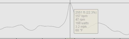
p.s.: here's another example of a local ride elevation chart from RWGPS. No, I didn't sign up for this one.
Last edited by Bald Paul; 05-10-21 at 11:03 AM.
05-10-21, 01:01 PM
#46
Senior Member
Join Date: Sep 2007
Location: Far beyond the pale horizon.
Posts: 14,297
Mentioned: 31 Post(s)
Tagged: 0 Thread(s)
Quoted: 4273 Post(s)
Liked 1,370 Times
in
951 Posts
(sigh)
That was precisely the point of my post. Here, let me recap for you - My friend, new to cycling, asked me to join him on the ride, thinking a 20 mile ride would be geared towards newer riders. Had the route been made available beforehand, we would not have participated. Is this such a difficult concept to read and comprehend?
That was precisely the point of my post. Here, let me recap for you - My friend, new to cycling, asked me to join him on the ride, thinking a 20 mile ride would be geared towards newer riders. Had the route been made available beforehand, we would not have participated. Is this such a difficult concept to read and comprehend?
It doesn't look like a screen shot from RWGPS.
Was this one of the rides at the event?
These events are open to the public. How hard is it to provide a link to the webpage for the event?
")
Last edited by njkayaker; 05-10-21 at 01:08 PM.
05-11-21, 06:05 AM
#47
Senior Member
Thread Starter
Join Date: Sep 2017
Location: Upstate SC
Posts: 1,716
Mentioned: 3 Post(s)
Tagged: 0 Thread(s)
Quoted: 829 Post(s)
Liked 1,678 Times
in
789 Posts
You aren't providing enough information about the rather unusual situation for people here to evaluate it.
???
It doesn't look like a screen shot from RWGPS.
Was this one of the rides at the event?
These events are open to the public. How hard is it to provide a link to the webpage for the event?
???
It doesn't look like a screen shot from RWGPS.
Was this one of the rides at the event?
These events are open to the public. How hard is it to provide a link to the webpage for the event?
Here's more information:
The route was a loop. There were left and right turns interspersed with straight sections of road. The surface was asphalt in reasonably good shape. I consumed approximately 21.3 oz of water during the ride. Tires were inflated to approximately 90 PSI. Now, punch all that into your supercomputer to determine if, IN GENERAL, you would prefer being able to preview the route before deciding to ride it.
Look at a route on RWGPS. Click the GRADE tab at the bottom. Expand the area you want to look at in detail. See? It really is a screenshot! No, the grade example posted was a local ride where the route WAS provided on RWGPS, and after looking at it, I decided NOT to attempt it.
It's extremely difficult to provide a link to the webpage for an event that occurred several years ago, and was advertised via a flyer posted in the LBS.
Now, I'm not answering any more questions until my lawyer arrives.
05-11-21, 07:11 AM
#48
Senior Member
Join Date: Sep 2007
Location: Far beyond the pale horizon.
Posts: 14,297
Mentioned: 31 Post(s)
Tagged: 0 Thread(s)
Quoted: 4273 Post(s)
Liked 1,370 Times
in
951 Posts
I'm going to humor you one more time before you go on my IGNORE list. (Feel free to do the same to me.)
Here's more information:
The route was a loop. There were left and right turns interspersed with straight sections of road. The surface was asphalt in reasonably good shape. I consumed approximately 21.3 oz of water during the ride. Tires were inflated to approximately 90 PSI. Now, punch all that into your supercomputer to determine if, IN GENERAL, you would prefer being able to preview the route before deciding to ride it.
Look at a route on RWGPS. Click the GRADE tab at the bottom. Expand the area you want to look at in detail. See? It really is a screenshot! No, the grade example posted was a local ride where the route WAS provided on RWGPS, and after looking at it, I decided NOT to attempt it.
It's extremely difficult to provide a link to the webpage for an event that occurred several years ago, and was advertised via a flyer posted in the LBS.
Now, I'm not answering any more questions until my lawyer arrives.
You are still bothered by this thing that happened years ago?
If you have access to the route, why wouldn't you look at it?
Do you really need to have people to tell you that?
Useless.
It's obviously a screen shot of something.What?? It's a screen of some completely different ride??
Last edited by njkayaker; 05-11-21 at 10:38 AM.
05-11-21, 07:19 AM
#49


Randomhead
Join Date: Aug 2008
Location: Happy Valley, Pennsylvania
Posts: 24,406
Mentioned: 0 Post(s)
Tagged: 0 Thread(s)
Quoted: 4 Post(s)
Liked 3,705 Times
in
2,524 Posts
sometimes you can find a ride on Strava or RWGPS even though the organizers didn't post a map. Or ask the organizers if they have the route posted online.
To be perfectly honest, I don't trust organizers not to put me on a drag strip without shoulders, so I'm fairly careful about checking the route ahead of time.
To be perfectly honest, I don't trust organizers not to put me on a drag strip without shoulders, so I'm fairly careful about checking the route ahead of time.
Likes For unterhausen:
05-11-21, 10:22 AM
#50
staring at the mountains

Join Date: Mar 2005
Location: Castle Pines, CO
Posts: 4,560
Bikes: Obed GVR, Fairdale Goodship, Salsa Timberjack 29
Mentioned: 6 Post(s)
Tagged: 0 Thread(s)
Quoted: 394 Post(s)
Liked 197 Times
in
112 Posts
I wouldn't sign up for an organized ride that didn't have the route published in some way such that it can be previewed. And yes, absolutely I preview. Strava/RideWGPS, etc. I actually tend to get a little ocd about trying to visualize the ride and its difficulty in the week(s) leading up to the event.
Likes For superdex: