


Great Plains Gravel Route
 02-10-23, 09:44 AM
#1
Senior Member
Thread Starter
Great Plains Gravel Route
My interest is just a little piqued by the teaser about this new route in the latest Adventure Cyclist magazine. It looks like it might hit a few of the right notes for me. Big Bend is on my bucket list. The flint Hills were awesome when I rode there in the spring some years ago. I have not ridden that portion of Oklahoma (the panhandle sucked on the route I crossed it). I have read that KS and NE can be interesting given the right route and I have enjoyed KS well enough on a few other trips. I have never seen the lowess hills. I have never set foot or rolled a wheel onto either of the Dakotas. So there are some potential attractions to the route for me
Anyone know more about the route than the article reveals?
It might be fun to do another tour on my old rigid mountail bike either with or without the drop bar setup it is outfitted with at the moment, My hardtail mountain bike that is my daily ride would be fun on a route like that as well. Also it could also be a reasonable excuse to buy a gravel bike.
I would think timing would mean starting in the south at a time that put you in the Flint Hills when they are that amazing green. I'd want to try to get to the Dakotas before it was too hot though. Hot sure if both of those are possible. Maybe hitting the Flint Hills in early Spring and making decent time would do it. I'd have to sit down with a route map and weatherspark to plan. Splitting it and doing half one year and half another doesn't really appeal to me, but could solve any weather timing issue.
 02-10-23, 10:53 AM
#2
Senior Member
Join Date: Aug 2010
Location: Madison, WI
Posts: 11,214
Bikes: 1961 Ideor, 1966 Perfekt 3 Speed AB Hub, 1994 Bridgestone MB-6, 2006 Airnimal Joey, 2009 Thorn Sherpa, 2013 Thorn Nomad MkII, 2015 VO Pass Hunter, 2017 Lynskey Backroad, 2017 Raleigh Gran Prix, 1980s Bianchi Mixte on a trainer. Others are now gone.
Mentioned: 48 Post(s)
Tagged: 0 Thread(s)
Quoted: 3462 Post(s)
Liked 1,468 Times
in
1,145 Posts
I do not get the magazine.I never heard of it. I did a google search, found this, but you probably have already found this too.
https://www.cyclingweekly.com/news/g...s-gravel-route
The map in that link looks like the line is too far east to go through South Dakota on the George S Mickelson trail. The Mickelson trail is rail trail through the Black Hills. I was there in a late August, the higher elevations were quite pleasant but the lower elevation at the southern end at Edgemont was in the 90s.
And it looks like it goes too far east to use the Maah Daah Hey trail in North Dakota, that connects Theodore Roosevelt National Park segments. The Maah Daah Hey trail is single track. I was there in an early Sep, weather was quite nice, but expect no water between the campgrounds, I was car camping while day riding on the trail and a lot of bikepackers came into the campgrounds badly dehydrated.
The line on that map is quite far east of Big Bend National Park. When I was there in an early April, weather ranged from quite hot to cold. One morning my water bottles were partly frozen, I had left them on my bike.
But maybe that line is just intended to be generalized and it might include some of these locales?
I suspect 2023 might be too early to plan to ride it.
02-10-23, 12:24 PM
#3
Senior Member
Thread Starter
I suspect 2023 might be too early to plan to ride it.
02-10-23, 12:39 PM
#4
Senior Member
Thread Starter
All that is based on my knowledge from my ride on the ST and the one through the Flint Hills. I may be ignoring factors in other areas that I don't know enough to worry about at this point.
02-10-23, 12:52 PM
#5
Senior Member
Join Date: Aug 2010
Location: Madison, WI
Posts: 11,214
Bikes: 1961 Ideor, 1966 Perfekt 3 Speed AB Hub, 1994 Bridgestone MB-6, 2006 Airnimal Joey, 2009 Thorn Sherpa, 2013 Thorn Nomad MkII, 2015 VO Pass Hunter, 2017 Lynskey Backroad, 2017 Raleigh Gran Prix, 1980s Bianchi Mixte on a trainer. Others are now gone.
Mentioned: 48 Post(s)
Tagged: 0 Thread(s)
Quoted: 3462 Post(s)
Liked 1,468 Times
in
1,145 Posts
I assume that is the case at least to some degree. It looks kind of "schematic" more than like an actual route.
Yeah, I was thinking more likely next year. assuming they really have the route completed this year at all. I don't think there is any chance details will be released for a Spring start this year and I think Spring looks likely to be the best time for this route.
Yeah, I was thinking more likely next year. assuming they really have the route completed this year at all. I don't think there is any chance details will be released for a Spring start this year and I think Spring looks likely to be the best time for this route.
From what we know it is impossible to say if the route will go past an Amtrak station or not. Amtrak goes through Williston ND and Alpine TX. If you skipped some of the distance at each end, you might be able to use Amtrak to get to near the start and near the finish.
02-10-23, 01:28 PM
#6
Newbie
I live in San Antonio, in South Texas, and I've done variations of this North/South line multiple times. Northbound is an unbelievable joy because of the Southern winds and I aim that direction almost every summer to begin my journey (it takes me 4 days to get out of Texas no matter which direction I take by the way). My tours are self made random routes that all begin and end at home and this proposed route you mention looks like a beauty! In 2016 I did that Southbound plummet from North Dakota back to Texas and it was really tough because of those headwinds. In '19 I was Northbound and easily pulled some of the highest daily mileages of my life. I can't get enough of these Great Plains for some reason. I'm piecing together another run up North right now, for June through August. Kansas, Nebraska- all of that- is really special. I think it has to do with the sense of accomplishment one gets crossing those big expanses. I've often suspected that the folks discussing East or West headwinds on their Transams were actually encountering variations of that mighty South wind. I'd be very excited to incorporate this gravel route as my outbound leg when it comes to fruition. On a side note I ride to Big Bend each November for my birthday and I promise you will very much enjoy that region. I'll be watching this project develop for sure.
Likes For zweitesmal2:
02-10-23, 03:20 PM
#7
Senior Member
Thread Starter
I live in San Antonio, in South Texas, and I've done variations of this North/South line multiple times. Northbound is an unbelievable joy because of the Southern winds and I aim that direction almost every summer to begin my journey (it takes me 4 days to get out of Texas no matter which direction I take by the way). My tours are self made random routes that all begin and end at home and this proposed route you mention looks like a beauty! In 2016 I did that Southbound plummet from North Dakota back to Texas and it was really tough because of those headwinds. In '19 I was Northbound and easily pulled some of the highest daily mileages of my life. I can't get enough of these Great Plains for some reason. I'm piecing together another run up North right now, for June through August. Kansas, Nebraska- all of that- is really special. I think it has to do with the sense of accomplishment one gets crossing those big expanses. I've often suspected that the folks discussing East or West headwinds on their Transams were actually encountering variations of that mighty South wind. I'd be very excited to incorporate this gravel route as my outbound leg when it comes to fruition. On a side note I ride to Big Bend each November for my birthday and I promise you will very much enjoy that region. I'll be watching this project develop for sure.
I know you do not like to carry much food. In the Dakotas, distances between grocery stores could be a factor. You might need to have some food mailed to you, but even post offices could be far between. But I would expect ACA to get all of that documented on a series of maps.
From what we know it is impossible to say if the route will go past an Amtrak station or not. Amtrak goes through Williston ND and Alpine TX. If you skipped some of the distance at each end, you might be able to use Amtrak to get to near the start and near the finish.
Also I wonder if 4wd pickup, jeep, or 2wd car support will be possible on this route. I am not usually into that, but my wife has made comments about driving support on a long tour. If we were to do that we'd do some other sight seeing on the way back home.
Last edited by staehpj1; 02-10-23 at 04:25 PM.
02-10-23, 04:31 PM
#8
Senior Member
Thread Starter
The route details are really vague at this point and I doubt that the map is a good indication of where the route actually goes. I'll just look forward to hearing more from Adventure Cycling unless someone is privy to more details.
02-10-23, 05:45 PM
#9

Hooked on Touring
I have toured the Great Plains extensively - especially Nebraska.
And I am a historian of rural communities - primarily in the West.
I agree - there is spectacular beauty and wonderful small towns.
But.
Weather is always a challenge - just ask Dorothy or the Okies heading west.
In spring the weather can run from pleasant in Texas to blizzards in the Dakotas.
Sames goes for the fall. And in summer it is scorching almost up to the Canadian border.
April, May, and June may be the best time, but it is also prime tornado season.
I'm not sure what the organizers consider to be "gravel".
I would warn any person touring to be cautious about unpaved roads in the Great Plains.
What might appear to be an average gravel road can turn into 4-inch deep sand pretty quickly.
Add a downpour to the mix when you are 20 miles from pavement and you have glue.
The finest scenery in the Plains is found in the least populated areas.
Yet, small towns have faced a brutal, steady outmigration since WWII.
Many little towns only had one or two businesses hanging on prior to covid.
And it seems that covid struck a serious hammer blow to them.
If there is a bar/cafe/store still open, vegan fare is unlikely to be on the menu.
Which brings us to a major cultural divide.
Many rural Plains counties vote 90% for the Republican Party in presidential elections.
Cyclists are often from far more liberal areas - east coast, west coast, even Omaha or Kansas City.
People in the High Plains overwhelmingly support pipelines and raising beef.
And they drive Ford F-350s towing horse trailers.
I would hope that anyone who is in a position to ride a bicycle for a month -
both financially and time-wise - would be aware of the cultural chasm.
Kathleen Norris' "Dakota, A Spiritual Geography" is a stunning book,
but she wrote it as a transplanted New Yorker.
City folk loved it - Dakotans found it condescending.
<<<>>>
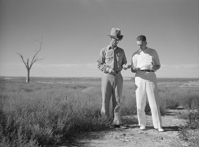
Attached is a 1930s photo of Rexford Tugwell in white pants and shoes telling a Dust Bowl farmer how to farm.
And I am a historian of rural communities - primarily in the West.
I agree - there is spectacular beauty and wonderful small towns.
But.
Weather is always a challenge - just ask Dorothy or the Okies heading west.
In spring the weather can run from pleasant in Texas to blizzards in the Dakotas.
Sames goes for the fall. And in summer it is scorching almost up to the Canadian border.
April, May, and June may be the best time, but it is also prime tornado season.
I'm not sure what the organizers consider to be "gravel".
I would warn any person touring to be cautious about unpaved roads in the Great Plains.
What might appear to be an average gravel road can turn into 4-inch deep sand pretty quickly.
Add a downpour to the mix when you are 20 miles from pavement and you have glue.
The finest scenery in the Plains is found in the least populated areas.
Yet, small towns have faced a brutal, steady outmigration since WWII.
Many little towns only had one or two businesses hanging on prior to covid.
And it seems that covid struck a serious hammer blow to them.
If there is a bar/cafe/store still open, vegan fare is unlikely to be on the menu.
Which brings us to a major cultural divide.
Many rural Plains counties vote 90% for the Republican Party in presidential elections.
Cyclists are often from far more liberal areas - east coast, west coast, even Omaha or Kansas City.
People in the High Plains overwhelmingly support pipelines and raising beef.
And they drive Ford F-350s towing horse trailers.
I would hope that anyone who is in a position to ride a bicycle for a month -
both financially and time-wise - would be aware of the cultural chasm.
Kathleen Norris' "Dakota, A Spiritual Geography" is a stunning book,
but she wrote it as a transplanted New Yorker.
City folk loved it - Dakotans found it condescending.
<<<>>>
Attached is a 1930s photo of Rexford Tugwell in white pants and shoes telling a Dust Bowl farmer how to farm.
Likes For jamawani:
02-10-23, 06:13 PM
#10
Senior Member
Join Date: Aug 2010
Location: Madison, WI
Posts: 11,214
Bikes: 1961 Ideor, 1966 Perfekt 3 Speed AB Hub, 1994 Bridgestone MB-6, 2006 Airnimal Joey, 2009 Thorn Sherpa, 2013 Thorn Nomad MkII, 2015 VO Pass Hunter, 2017 Lynskey Backroad, 2017 Raleigh Gran Prix, 1980s Bianchi Mixte on a trainer. Others are now gone.
Mentioned: 48 Post(s)
Tagged: 0 Thread(s)
Quoted: 3462 Post(s)
Liked 1,468 Times
in
1,145 Posts
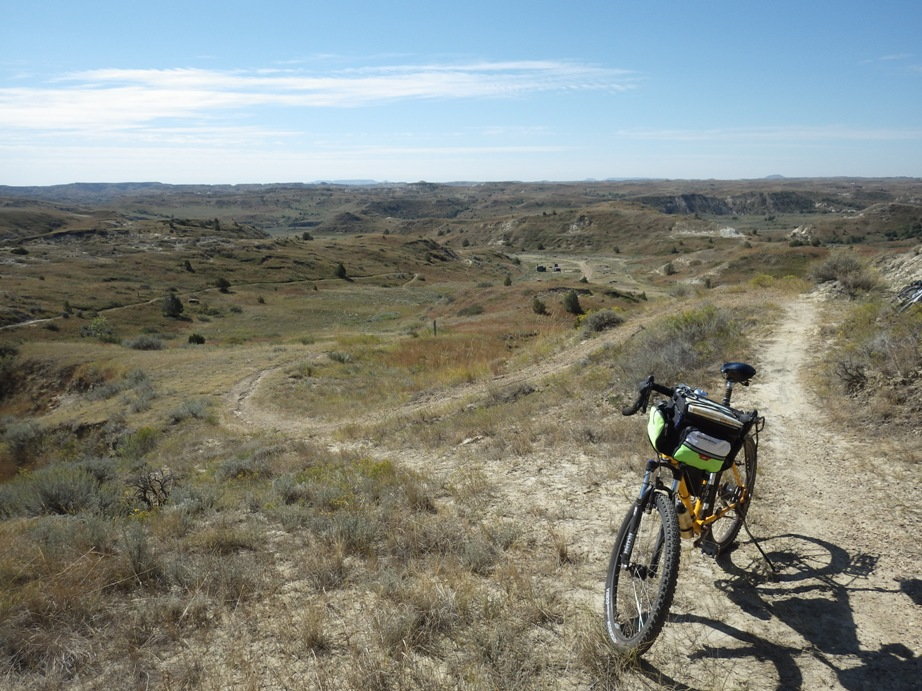
First photo below, the campsite we stayed at for one night is in the distance in the photo on the right, but it is so empty at the time of photo you might not be able to make it out. We were car camping and doing day trips on the trail. I put a suspension fork on my heavy touring bike, I do not have a mountain bike.
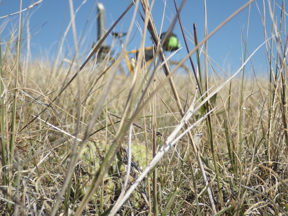
Second photo, this is a forewarning, this photo was on the Maah Daah Hey trail, yes they even have thorn bushes up where it gets down to minus 40 degrees in winter.
I do not know what you use for basemaps in a GPS, but these topo maps might be nice to have. The contour lines are far between, and the lines are metric so you see odd contour intervals. But overall I find them useful to have sometimes when off major routes.
USA OSM Topo Routable | GMapTool
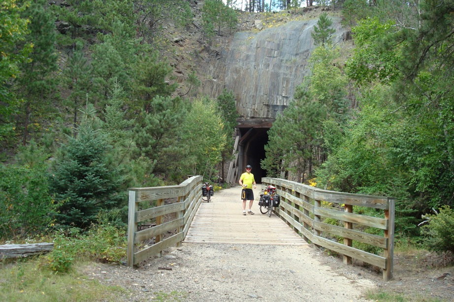
But the Mickelson trail is an old rail trail, so not as rough, an off the shelf gravel bike would work well. I did that in 2009 when my high end expensive digital camera was 3 megapixel, so I do not have enough photos to really show off much. My riding partner borrowed a camera with more pixels, this is from his camera. From the presence of a lot of trees, this clearly is in the Black Hills.
I could get interested in a trip like this too.
02-10-23, 06:17 PM
#11
Senior Member
Join Date: Aug 2010
Location: Madison, WI
Posts: 11,214
Bikes: 1961 Ideor, 1966 Perfekt 3 Speed AB Hub, 1994 Bridgestone MB-6, 2006 Airnimal Joey, 2009 Thorn Sherpa, 2013 Thorn Nomad MkII, 2015 VO Pass Hunter, 2017 Lynskey Backroad, 2017 Raleigh Gran Prix, 1980s Bianchi Mixte on a trainer. Others are now gone.
Mentioned: 48 Post(s)
Tagged: 0 Thread(s)
Quoted: 3462 Post(s)
Liked 1,468 Times
in
1,145 Posts
I live in San Antonio, in South Texas, and I've done variations of this North/South line multiple times. Northbound is an unbelievable joy because of the Southern winds and I aim that direction almost every summer to begin my journey (it takes me 4 days to get out of Texas no matter which direction I take by the way). My tours are self made random routes that all begin and end at home and this proposed route you mention looks like a beauty! In 2016 I did that Southbound plummet from North Dakota back to Texas and it was really tough because of those headwinds. In '19 I was Northbound and easily pulled some of the highest daily mileages of my life. I can't get enough of these Great Plains for some reason. I'm piecing together another run up North right now, for June through August. Kansas, Nebraska- all of that- is really special. I think it has to do with the sense of accomplishment one gets crossing those big expanses. I've often suspected that the folks discussing East or West headwinds on their Transams were actually encountering variations of that mighty South wind. I'd be very excited to incorporate this gravel route as my outbound leg when it comes to fruition. On a side note I ride to Big Bend each November for my birthday and I promise you will very much enjoy that region. I'll be watching this project develop for sure.
02-10-23, 08:09 PM
#12
Hooked on Touring
Summer has more southerly, winter more northerly. Spring and fall about equal.
And the wind shift is dramatic when a front goes through.
You can have 25-30 mph southerlies and the next morning 25-30 mph northerlies.
Summer can be brutally hot in the Great Plains - just check out some Crazyguy journals.
Spring and fall have highly changeable weather patterns.
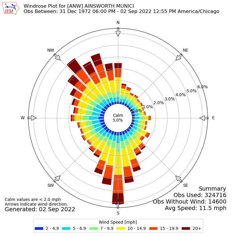
https://mesonet.agron.iastate.edu/si...etwork=NE_ASOS
 02-11-23, 06:23 AM
#13
Full Member
Join Date: Sep 2005
Location: Tulsa, OK
Posts: 451
Bikes: Co-Motion Americano Pinion P18; Co-Motion Americano Rohloff; Thorn Nomad MkII, Robert Beckman Skakkit (FOR SALE), Santana Tandem, ICE Adventure FS
Mentioned: 1 Post(s)
Tagged: 0 Thread(s)
Quoted: 169 Post(s)
Liked 64 Times
in
48 Posts
Actually, in the Great Plains there are about equal northerly and southerly winds.
Summer has more southerly, winter more northerly. Spring and fall about equal.
And the wind shift is dramatic when a front goes through.
You can have 25-30 mph southerlies and the next morning 25-30 mph northerlies.
Summer can be brutally hot in the Great Plains - just check out some Crazyguy journals.
Spring and fall have highly changeable weather patterns.
https://mesonet.agron.iastate.edu/si...etwork=NE_ASOS
02-11-23, 07:11 AM
#14
Senior Member
Thread Starter
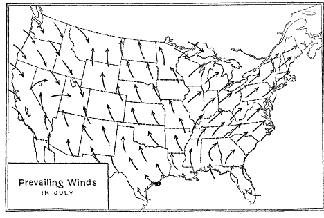
I like to point to a sort of crude drawing I ran across for general summer winds. It is a drawing map representing July winds in the US. It doesn't give the level of detail you can get from wind roses and is only for one time of year, but it does show an overall picture. Sites like Windy.com give a similar, but detailed live picture. I thought they had the ability to look at dates in the past, but I don't see that at this time. Perhaps my memory is faulty of maybe that is now only part of a paid account.
Anyway, this little drawing seems to match my experiences of what I experienced in the summer. I may be inclined to start this trip t too early in the season for it to be useful and as mentioned elsewhere the winds on the plains can be quite variable. Still in Summer on the plains there were way more days with SE winds than anything else IME.
 02-11-23, 01:21 PM
#15
Hooked on Touring
Here's what I said -
Actually, in the Great Plains there are about equal northerly and southerly winds.
Summer has more southerly, winter more northerly. Spring and fall about equal.
And the wind shift is dramatic when a front goes through.
You can have 25-30 mph southerlies and the next morning 25-30 mph northerlies.
Summer can be brutally hot in the Great Plains - just check out some Crazyguy journals.
Spring and fall have highly changeable weather patterns.
There is nothing misleading about it for people who read.
You can go to the Iowa State University website and get monthly charts.
I've probably done more Great Plains riding and touring than most people here.
And did my doctoral work at K.U. in Lawrence while living in Topeka.
I can assure that the months where southerlies prevail - late June thru late Sept. -
are pretty darn brutal temperature-wise. Without shade on remote roads.
I stand by what my initial framing argues -
In the months with the best termperatures for riding - southerlies and northerlies are roughly equal.
Also, if you have ever ridden on a 100+ day with a tailwind -
you can find yourself in a still-air pocket
and are usually praying for a sidewind or a headwind.
Just sayin'.
02-11-23, 01:39 PM
#16
Senior Member
Join Date: Aug 2010
Location: Madison, WI
Posts: 11,214
Bikes: 1961 Ideor, 1966 Perfekt 3 Speed AB Hub, 1994 Bridgestone MB-6, 2006 Airnimal Joey, 2009 Thorn Sherpa, 2013 Thorn Nomad MkII, 2015 VO Pass Hunter, 2017 Lynskey Backroad, 2017 Raleigh Gran Prix, 1980s Bianchi Mixte on a trainer. Others are now gone.
Mentioned: 48 Post(s)
Tagged: 0 Thread(s)
Quoted: 3462 Post(s)
Liked 1,468 Times
in
1,145 Posts
I just picked Nebraska as a bit past the half way point if you start at the south end and go north. And I picked eastern Nebraska where the elevation is still lower instead of western Nebraska, and from that I picked Lincoln Nebraska for sample weather in the mid to late part of the trip.
https://weatherspark.com/y/146009/Av...tes-Year-Round
April and May, the wind direction starts to show a predominant south wind, that is stronger later when it gets hotter. Average wind speed peaks in Apr, steadily drops off until Aug. Apr is wet, May and Jun are wetter with heaviest amount of rain in late May. Early Jun is when probability of precip is greatest at about 40 percent. They define a wet day as having a mm (or about 0.04 inch) of rain, if you had sprinkles less than a total of 1mm, it did not rain that day. July and early Aug are the worst for heat and humidity, but someone from Florida would probably feel right at home then.
Based on that wind data, I would not want to be going North to South in late summer, the wind is weaker then compared to spring but you are going against it.
02-11-23, 01:47 PM
#17
Palmer

Join Date: Mar 2007
Location: Parts Unknown
Posts: 8,627
Bikes: Mike Melton custom, Alex Moulton AM, Dahon Curl
Mentioned: 37 Post(s)
Tagged: 0 Thread(s)
Quoted: 1671 Post(s)
Liked 1,827 Times
in
1,063 Posts
Hmm. Interesting tour route proposal.
I grew up in the Great Plains. I love it. My experience has been that if one isn't from there, there is a low percentage chance of appreciating it. That's why we get tour reports like "TransAm - the Dreaded Middle Third" and "The Road to Nowhere". This was an area the 49ers and wagon trains crossed, not a destination for them. It's home to ~1% of the American population.
Clifford Graves once said, "There is some fine cycling even in Texas, but you have to look for it with a candle. The West has many beauty spots, but they are hidden in vast stretches of indifferent country." Yeah, he was from Southern California, not the Great Plains.
Last edited by tcs; 02-11-23 at 01:58 PM.
02-11-23, 01:49 PM
#18
Hooked on Touring
One year I stopped at a little country store in northern South Dakota - Roscoe, I think.
The cashier asked which way I was going and I said I was heading north.
She replied, "That must be really exhausting since you are going uphill all the time."
02-11-23, 02:13 PM
#19
Palmer
Join Date: Mar 2007
Location: Parts Unknown
Posts: 8,627
Bikes: Mike Melton custom, Alex Moulton AM, Dahon Curl
Mentioned: 37 Post(s)
Tagged: 0 Thread(s)
Quoted: 1671 Post(s)
Liked 1,827 Times
in
1,063 Posts
Some of this Great Plains Gravel Route is along tours I've sketched for contemplation.
Black Hills to Sand Hills
https://ridewithgps.com/routes/38455430
Sand Hills to Flint Hills
https://ridewithgps.com/routes/38455464
Flint Hills
https://ridewithgps.com/routes/38462328
Not 'gravel' routes per se, but yeah, 'the tour continues even if the pavement doesn't'. Oh, but take RideWithGPS's pavement/no pavement indications with a grain of salt.
Last edited by tcs; 02-11-23 at 04:29 PM.
02-11-23, 03:08 PM
#20
bicycle tourist
As far as wind on the Great Plains goes, I always liked this map: https://windhistory.com/map.html#7.00/36.094/-98.751 It shows not just one wind rose but multiple roses on the map and lets you click on top right and pick the months. For example, here is a selection centered on the 100th Meridian with the months from April to October inclusive picked but you can make your own selections.
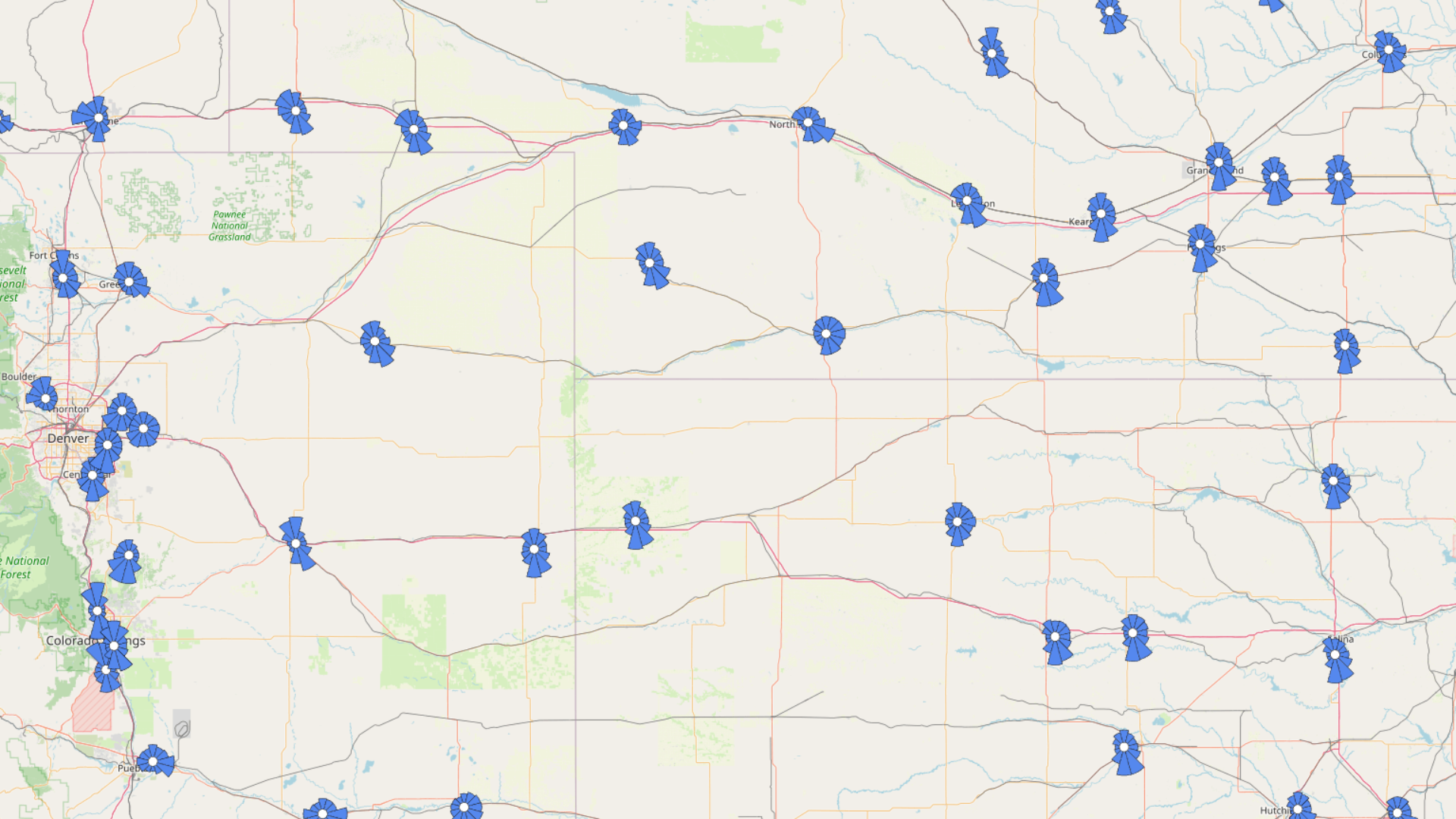
In general, I like picking the 100th Meridian as the classic dividing line between a more humid east and more arid west. It also happens to align with where vegetation, water law and other changes happen as well. I have read (https://news.climate.columbia.edu/20...w-moving-east/) that this has more recently been edging eastwards more to the 98th Meridian or so.
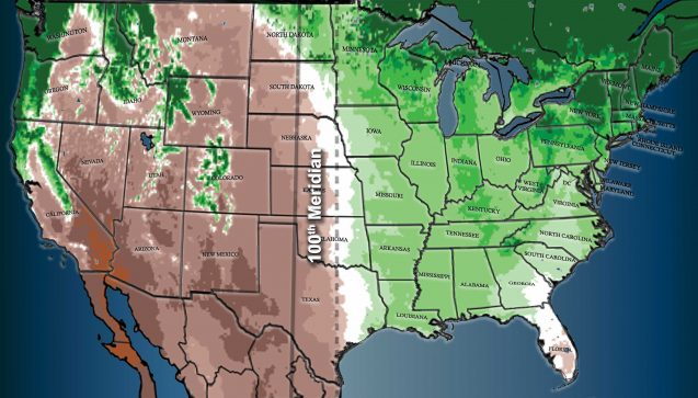
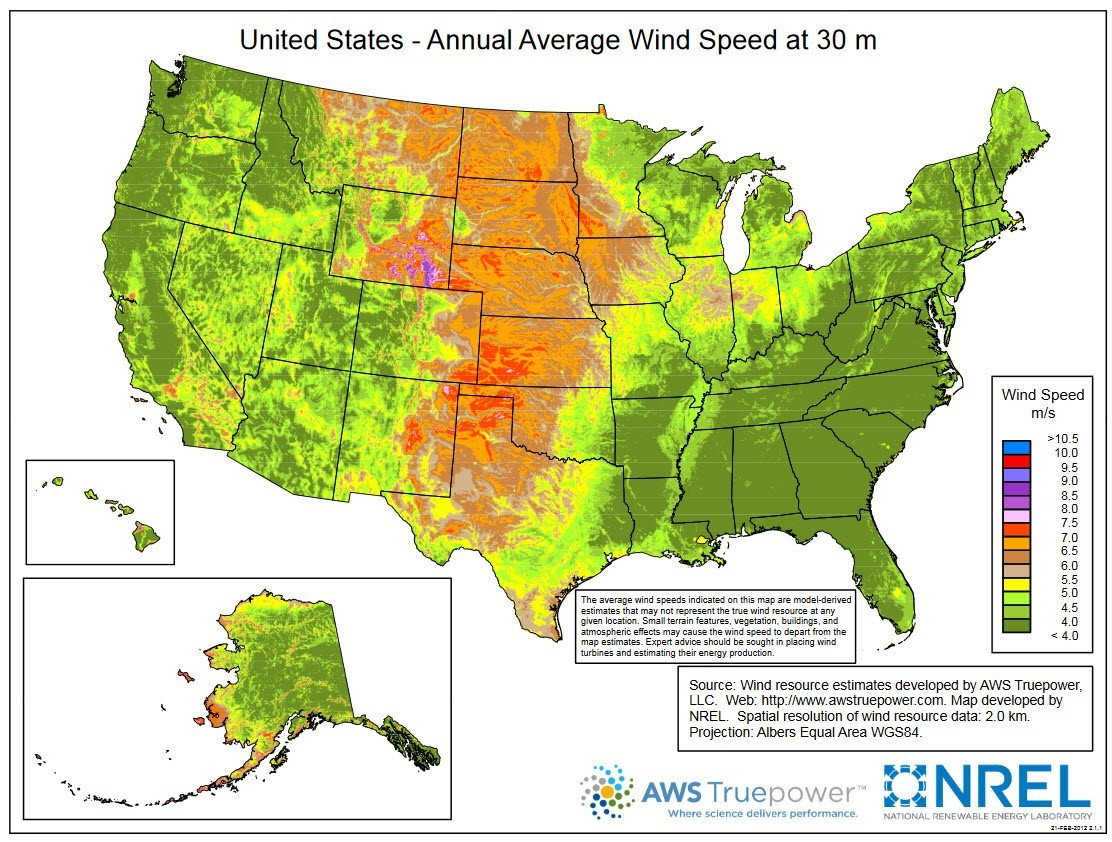
This also happens to correlate with higher average wind speeds throughout the year (https://windexchange.energy.gov/maps-data/325)
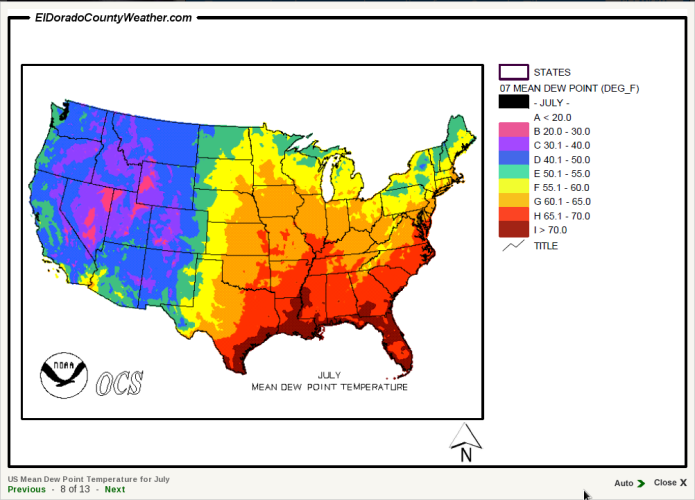
Not a gravel route, but in 2018 I cycled US 83 (https://en.wikipedia.org/wiki/U.S._Route_83) a major highway that isn't too far from the 100th Meridian starting in July. When I looked at the climate maps (e.g. below) including wind roses, I realized that dew point was at least as important to me as temperature. so I wanted to stay a little further west. Places like Lawrence Kansas are pretty far east (close to the 95th) and hence on average also more muggy/humid than the Great Plains region @tcs highlights in post #17. So I would either be tempted to avoid the hottest summer months or pick a slightly more westerly route than the gravel route shown in the great plains map. In most of those states a Delorme Atlas gives a good overview of potential county roads. My experience with gravel county roads at least in Colorado (*) was many are can be in good condition but get some rain and it becomes a lot more variable in mud conditions.
On my July US 83 trip, it was hot the first days in Texas and I ended up going early and finishing by noon. After that I got slightly cooler weather patterns and it was fine. I also had some delightful tailwinds and more tailwinds than headwinds.
(*) A portion of my gravel road/plains experience came when I was in Fort Collins Colorado and started an enterprise to cycle all the gravel roads in Weld County. Weld County (https://en.wikipedia.org/wiki/Weld_County,_Colorado) has about 2000 miles of gravel roads and I only got about 30% of them before moving. However for that county at least, I learned there were some slightly better "arterials" with good surfacing even in bad conditions - and then some that really turned slick/muddy with not much rain. Fortunately, it didn't rain very much in that area. // I also saw some of this crossing into western Kansas, particularly when I stumbled onto the fact that my maps indicated mixed pavement/gravel for old US-40 but several counties had since ripped up the old pavement. // My third instance was in letting my GPS guide my rental car on gravel roads near Plains, TX and unfortunately getting stuck in some deep mud.
In general, I like picking the 100th Meridian as the classic dividing line between a more humid east and more arid west. It also happens to align with where vegetation, water law and other changes happen as well. I have read (https://news.climate.columbia.edu/20...w-moving-east/) that this has more recently been edging eastwards more to the 98th Meridian or so.
This also happens to correlate with higher average wind speeds throughout the year (https://windexchange.energy.gov/maps-data/325)
Not a gravel route, but in 2018 I cycled US 83 (https://en.wikipedia.org/wiki/U.S._Route_83) a major highway that isn't too far from the 100th Meridian starting in July. When I looked at the climate maps (e.g. below) including wind roses, I realized that dew point was at least as important to me as temperature. so I wanted to stay a little further west. Places like Lawrence Kansas are pretty far east (close to the 95th) and hence on average also more muggy/humid than the Great Plains region @tcs highlights in post #17. So I would either be tempted to avoid the hottest summer months or pick a slightly more westerly route than the gravel route shown in the great plains map. In most of those states a Delorme Atlas gives a good overview of potential county roads. My experience with gravel county roads at least in Colorado (*) was many are can be in good condition but get some rain and it becomes a lot more variable in mud conditions.
On my July US 83 trip, it was hot the first days in Texas and I ended up going early and finishing by noon. After that I got slightly cooler weather patterns and it was fine. I also had some delightful tailwinds and more tailwinds than headwinds.
(*) A portion of my gravel road/plains experience came when I was in Fort Collins Colorado and started an enterprise to cycle all the gravel roads in Weld County. Weld County (https://en.wikipedia.org/wiki/Weld_County,_Colorado) has about 2000 miles of gravel roads and I only got about 30% of them before moving. However for that county at least, I learned there were some slightly better "arterials" with good surfacing even in bad conditions - and then some that really turned slick/muddy with not much rain. Fortunately, it didn't rain very much in that area. // I also saw some of this crossing into western Kansas, particularly when I stumbled onto the fact that my maps indicated mixed pavement/gravel for old US-40 but several counties had since ripped up the old pavement. // My third instance was in letting my GPS guide my rental car on gravel roads near Plains, TX and unfortunately getting stuck in some deep mud.
Last edited by mev; 02-11-23 at 03:12 PM.
Likes For mev:
02-13-23, 08:29 AM
#21
Senior Member
Thread Starter
I hope they get some more route info out fairly early in the year if not fully complete the route and have maps up for sale. I'd like to get a better handle on what to expect of the route so I know whether I want to do it in 2024 and if so what I need to be prepared for.
When backpacking these days I like to limit myself to carrying no more than 4-5 days of food at most, but really water is the tough part. It doesn't have to be too far between resupply before water gets heavy. I'd expect that similar limitations will apply to a gravel tour for me. I might be more willing to haul a heavier load on the bike than when backpacking especially if it is for limited stretches, but I am really and skeptical about resorting to carrying heavy loads for the majority of the ride. If a support vehicle could either be right on the route or close by and able to set caches that might solve the water issue in some places. I am generally not a fan of using support vehicles though.
All that said I have gotten spoiled with UL packing techniques and frequent resupply so heavy loads will be hard to adapt to. Still I am not one who is unwilling to try different types of trips. Heavy loads would limit my mileage if there is much climbing. That is bad news because limited mileage means even heavier loads.
I might like to try a shorter (maybe 300-600 miles?) trip similar to the terrain and logistics expected on the GPGR this year as kind of a dry run, but I don't feel like we really have a very good handle on what that is.
02-13-23, 08:44 AM
#22
Senior Member

Join Date: Apr 2012
Location: Middle Earth (aka IA)
Posts: 20,435
Bikes: A bunch of old bikes and a few new ones
Mentioned: 178 Post(s)
Tagged: 0 Thread(s)
Quoted: 5888 Post(s)
Liked 3,472 Times
in
2,079 Posts
I will want to check out parts of this proposed trail as I'm close to NE and I'm always up for finding new routes to take on my vintage MTB.
02-13-23, 06:22 PM
#23
Hooked on Touring
One of the challenges for this route will be camping/lodging.
Towns are few and far between - although they will often let you camp in the town park.
Public lands are even harder to come by. Nearly all the land is privately held.
There are state wildlife areas - some of which allow primitive camping.
But most of them have no potable water and little to zero cover.
Here is a map of the Nebraska Sandhills showing public lands -
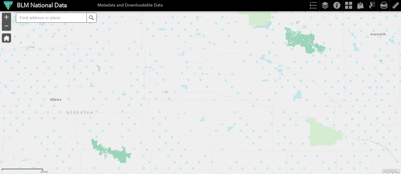
The dark green is National Wildlife Refuge land which prohibits camping.
The light green is National Forest land which allows dispersed and developed camping.
(But they were strange non-native forestry experiments in the early 20th century which don't belong.)
The light blue represents state lands much of which - especially the single sections - is privately leased.
Don't camp on sections 16 or 36 unless you are not certain it is open to the public.
Here is the Nebraska online public access atlas - designed primarily for hunting and fishing.
Also, remember that state wildlife areas that do permit camping are funded by hunting and fishing licenses.
Public Access Atlas - Nebraska Game and ParksNebraska Game and Parks |
Towns are few and far between - although they will often let you camp in the town park.
Public lands are even harder to come by. Nearly all the land is privately held.
There are state wildlife areas - some of which allow primitive camping.
But most of them have no potable water and little to zero cover.
Here is a map of the Nebraska Sandhills showing public lands -
The dark green is National Wildlife Refuge land which prohibits camping.
The light green is National Forest land which allows dispersed and developed camping.
(But they were strange non-native forestry experiments in the early 20th century which don't belong.)
The light blue represents state lands much of which - especially the single sections - is privately leased.
Don't camp on sections 16 or 36 unless you are not certain it is open to the public.
Here is the Nebraska online public access atlas - designed primarily for hunting and fishing.
Also, remember that state wildlife areas that do permit camping are funded by hunting and fishing licenses.
Public Access Atlas - Nebraska Game and ParksNebraska Game and Parks |
02-14-23, 08:52 AM
#24
Full Member
Join Date: Sep 2005
Location: Tulsa, OK
Posts: 451
Bikes: Co-Motion Americano Pinion P18; Co-Motion Americano Rohloff; Thorn Nomad MkII, Robert Beckman Skakkit (FOR SALE), Santana Tandem, ICE Adventure FS
Mentioned: 1 Post(s)
Tagged: 0 Thread(s)
Quoted: 169 Post(s)
Liked 64 Times
in
48 Posts
Mev, I REALLY like the Wind Rose website you posted. Thanks!
Likes For John N:
