


GPS unit recommendation?
 10-22-23, 02:30 PM
#1
Newbie
Thread Starter
Join Date: Jan 2018
Location: Ottawa
Posts: 17
Mentioned: 0 Post(s)
Tagged: 0 Thread(s)
Quoted: 25 Post(s)
Likes: 0
Liked 4 Times
in
3 Posts
GPS unit recommendation?
I'm looking for a simple GPS unit, something that could supplement my phone with its poor battery life. I don't need anything fancy in terms of recording health data and performance, which I don't care about, but I want good maps, with trails and contour lines, for bikepacking trips. I don't have experience with those tools, but I've seen some that had terrible maps. Ideally I would like to be able to upload a RWGPS route and map. Can anyone recommend something I could possibly find used, so not the newest model?
 10-22-23, 02:39 PM
#2
Full Member
I'm looking for a simple GPS unit, something that could supplement my phone with its poor battery life. I don't need anything fancy in terms of recording health data and performance, which I don't care about, but I want good maps, with trails and contour lines, for bikepacking trips. I don't have experience with those tools, but I've seen some that had terrible maps. Ideally I would like to be able to upload a RWGPS route and map. Can anyone recommend something I could possibly find used, so not the newest model?
How about buy a new phone? Or, replace with a new battery in that phone, if that is possible? You get new phone, new battery, and new map app. You profit 3 times.
") 10-22-23, 02:52 PM
10-22-23, 02:52 PM
#3
Senior Member
Join Date: Jul 2007
Location: South shore, L.I., NY
Posts: 6,964
Bikes: Flyxii FR322, Cannondale Topstone, Miyata City Liner, Specialized Chisel, Specialized Epic Evo
Mentioned: 18 Post(s)
Tagged: 0 Thread(s)
Quoted: 3305 Post(s)
Liked 2,143 Times
in
1,210 Posts
Garmin Edge Explore 2 is their model that doesn't deal with all the performance and training functions of the more expensive models. Screen size is close to the top of the line 1040, is a touch screen so zooming and panning on the map is easy. Can easily download routes created in either Garmin Connect or Ride With GPS. Runs about $300
Likes For Steve B.:
10-23-23, 12:44 AM
#4
Senior Member
Join Date: Aug 2010
Location: Madison, WI
Posts: 11,294
Bikes: 1961 Ideor, 1966 Perfekt 3 Speed AB Hub, 1994 Bridgestone MB-6, 2006 Airnimal Joey, 2009 Thorn Sherpa, 2013 Thorn Nomad MkII, 2015 VO Pass Hunter, 2017 Lynskey Backroad, 2017 Raleigh Gran Prix, 1980s Bianchi Mixte on a trainer. Others are now gone.
Mentioned: 48 Post(s)
Tagged: 0 Thread(s)
Quoted: 3503 Post(s)
Liked 1,489 Times
in
1,162 Posts
Garmin makes several different models of GPS that are general recreation that you can buy the optional GPS mount for handlebar.
The one I use is a Garmin 64, no longer sold but I think some of the 64 family are still sold as new old stock. I also use a 62S that has been out of production for several years. I know several randonneurs that use a Garmin Etrex GPS but I do not know exactly what model they use. You can put micro sized SD memory cards into some of these GPS units to hold extra maps.
Those GPS units use AA batteries. I use Ikea Ladda NiMH 2450 rechargeable AA batteries. Backpacking, I get about a day and a half on a pair of batteries, I carry as many spares as I think I may need. Bike touring, I recharge the batteries on my bike with a dynohub, but that is off topic.
Garmin also makes some Li Ion powered GPS units, but I am ignorant of those models.
These GPS units have to be plugged into a computer to load a RWGPS route or to load maps.
Maps are available from a couple of sources, but you need some computer skills to load the maps into the GPS. Example of two sources of maps that I have used are:
- For bike maps, https://extract.bbbike.org/
- For topo maps that can be loaded into a Garmin GPS for backpacking, https://www.gmaptool.eu/en/content/u...-topo-routable
But the above listed topo maps, they changed their formatting recently, and I had to go through a lot of hoops and hurdles to load them into my GPS. Much more complicated than I would want to try to explain. And the topo maps from that source, the topo lines are in metric increments and are not very close together.
NJKayaker on this forum might have some good suggestions, he is knowledgeable on this topic, but if you lack some computer skills, that might not be very helpful. Loading some of the maps from free internet sources is often from websites that are not very user friendly if your computer skills are not really good.
My Garmin 64, in use, below, photo is four years old on a bike tour:
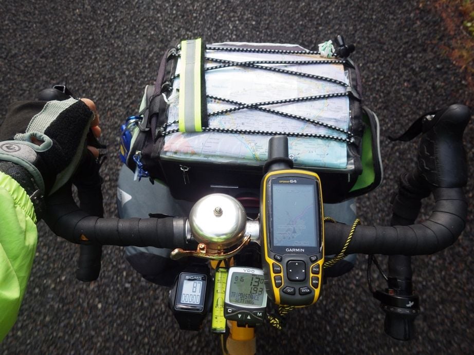
I have on several occasions not gotten my GPS into the handlebar mount quite right (user error), thus I was really happy that I used a tether cord on the GPS to keep it from falling on the ground. If you get a GPS like this, I suggest a tether, my tether in the photo above is the yellow and black cord.
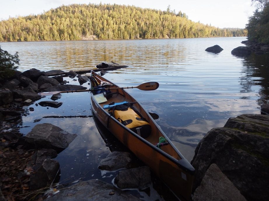
I use the older Garmin 62S for backpacking and canoe trips, but the 64 would work just as well. The 62S is mounted on my foot brace in my solo canoe using a handlebar mount, but it is a bit hard to see in this one year old photo.
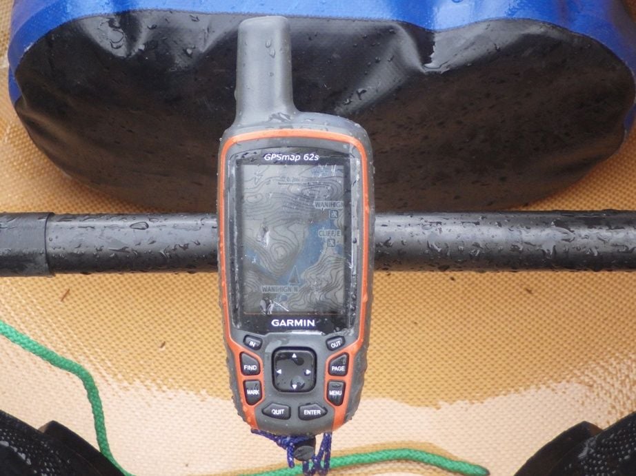
This year I used the Garmin 62S for 11 days of backpacking on the Superior Hiking Trail. My older 62S I think has some internal damage and sometimes it shuts off, when it finally dies I will chuck it and use the 64. Garmin no longer repairs that model.
I recently (last month) bought a used Garmin 64 ST on Ebay for when my 62S or 64 finally die. That included a better topo map that was loaded at the factory.
If you live near an REI store, you could ask them what models would meet your needs. But they are probably not going to be able to help with loading free maps from the internet.
ADDENDUM:
Added photo of my 62S mounted on the foot brace of my canoe.
The one I use is a Garmin 64, no longer sold but I think some of the 64 family are still sold as new old stock. I also use a 62S that has been out of production for several years. I know several randonneurs that use a Garmin Etrex GPS but I do not know exactly what model they use. You can put micro sized SD memory cards into some of these GPS units to hold extra maps.
Those GPS units use AA batteries. I use Ikea Ladda NiMH 2450 rechargeable AA batteries. Backpacking, I get about a day and a half on a pair of batteries, I carry as many spares as I think I may need. Bike touring, I recharge the batteries on my bike with a dynohub, but that is off topic.
Garmin also makes some Li Ion powered GPS units, but I am ignorant of those models.
These GPS units have to be plugged into a computer to load a RWGPS route or to load maps.
Maps are available from a couple of sources, but you need some computer skills to load the maps into the GPS. Example of two sources of maps that I have used are:
- For bike maps, https://extract.bbbike.org/
- For topo maps that can be loaded into a Garmin GPS for backpacking, https://www.gmaptool.eu/en/content/u...-topo-routable
But the above listed topo maps, they changed their formatting recently, and I had to go through a lot of hoops and hurdles to load them into my GPS. Much more complicated than I would want to try to explain. And the topo maps from that source, the topo lines are in metric increments and are not very close together.
NJKayaker on this forum might have some good suggestions, he is knowledgeable on this topic, but if you lack some computer skills, that might not be very helpful. Loading some of the maps from free internet sources is often from websites that are not very user friendly if your computer skills are not really good.
My Garmin 64, in use, below, photo is four years old on a bike tour:
I have on several occasions not gotten my GPS into the handlebar mount quite right (user error), thus I was really happy that I used a tether cord on the GPS to keep it from falling on the ground. If you get a GPS like this, I suggest a tether, my tether in the photo above is the yellow and black cord.
I use the older Garmin 62S for backpacking and canoe trips, but the 64 would work just as well. The 62S is mounted on my foot brace in my solo canoe using a handlebar mount, but it is a bit hard to see in this one year old photo.
This year I used the Garmin 62S for 11 days of backpacking on the Superior Hiking Trail. My older 62S I think has some internal damage and sometimes it shuts off, when it finally dies I will chuck it and use the 64. Garmin no longer repairs that model.
I recently (last month) bought a used Garmin 64 ST on Ebay for when my 62S or 64 finally die. That included a better topo map that was loaded at the factory.
If you live near an REI store, you could ask them what models would meet your needs. But they are probably not going to be able to help with loading free maps from the internet.
ADDENDUM:
Added photo of my 62S mounted on the foot brace of my canoe.
Last edited by Tourist in MSN; 10-23-23 at 08:07 AM.
10-23-23, 06:08 AM
#5
Senior Member
Join Date: Feb 2016
Location: SE Wisconsin
Posts: 1,855
Bikes: Lemond '01 Maillot Jaune, Lemond '02 Victoire, Lemond '03 Poprad, Lemond '03 Wayzata DB conv(Poprad), '79 AcerMex Windsor Carrera Professional(pur new), '88 GT Tequesta(pur new), '01 Bianchi Grizzly, 1993 Trek 970 DB conv, Trek 8900 DB conv
Mentioned: 12 Post(s)
Tagged: 0 Thread(s)
Quoted: 759 Post(s)
Likes: 0
Liked 811 Times
in
471 Posts
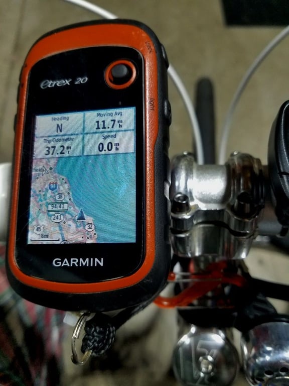
I use a Garmin Etrex 20 for cycling, kayaking, and hiking. Small, waterproof, and a set of regular alkaline AA batts gives you something like 24 hrs of running time. For biking I load GPX Track files from RWGPS through Basecamp.
You can customize the view to show four elements of your choosing. See the pic below for my setup. I typically set the screen view at 500 feet and the track is easy to follow. I have an extra SD storage chip installed, but the internal storage is plenty big to hold many tracks as the track files themselves are very small(just a collection of gps waypoints). My unit is 6-7 years old and works fine. There is(was) an Etrex 30 that has some extra features. Not sure if the Etrex series is still in their current lineup, but there will be similar units available. There should be plenty of them around used I'd think.
Like T-MSN, I have it mounted on the handle bar with a slip-in mount. There are mounts for the Etrex available for hiking(belt clip-on), cycling..etc. I have found the aftermarket cycling-bar mounts to fit/lock into the unit to be loose. I heat them up with a heat gun and bend the lock end up a little to make them lock into the unit tighter. I also use a tether around the stem just in case it gets bumped off the mount.
Some folks like to use their phones for navigation. I haven't had much luck with that route, even though the screen size is great, as the battery dies in short order when actively navigating a complicated route. I'd rather keep my phone battery in good shape in case I need the phone for a call if I, or someone else, needs emergency help..etc..
Last edited by fishboat; 10-23-23 at 06:29 AM.
Likes For fishboat:
10-23-23, 08:04 AM
#6
Senior Member
Join Date: Aug 2010
Location: Madison, WI
Posts: 11,294
Bikes: 1961 Ideor, 1966 Perfekt 3 Speed AB Hub, 1994 Bridgestone MB-6, 2006 Airnimal Joey, 2009 Thorn Sherpa, 2013 Thorn Nomad MkII, 2015 VO Pass Hunter, 2017 Lynskey Backroad, 2017 Raleigh Gran Prix, 1980s Bianchi Mixte on a trainer. Others are now gone.
Mentioned: 48 Post(s)
Tagged: 0 Thread(s)
Quoted: 3503 Post(s)
Liked 1,489 Times
in
1,162 Posts
...
... I have found the aftermarket cycling-bar mounts to fit/lock into the unit to be loose. I heat them up with a heat gun and bend the lock end up a little to make them lock into the unit tighter. I also use a tether around the stem just in case it gets bumped off the mount.
.....
... I have found the aftermarket cycling-bar mounts to fit/lock into the unit to be loose. I heat them up with a heat gun and bend the lock end up a little to make them lock into the unit tighter. I also use a tether around the stem just in case it gets bumped off the mount.
.....
10-23-23, 08:07 AM
#7
Deraill this!
Join Date: Jun 2019
Location: Central Ohio
Posts: 656
Bikes: 18 Cdale Quick 1, 94 S-Works M2, 98 730 Multitrak, and a few others
Mentioned: 4 Post(s)
Tagged: 0 Thread(s)
Quoted: 146 Post(s)
Liked 452 Times
in
263 Posts
Garmin Edge Explore 2 is their model that doesn't deal with all the performance and training functions of the more expensive models. Screen size is close to the top of the line 1040, is a touch screen so zooming and panning on the map is easy. Can easily download routes created in either Garmin Connect or Ride With GPS. Runs about $300
10-23-23, 09:05 AM
#8
Full Member
I think that in the Garmin Edge bike computer series, only the latest versions (540, 840, 1040) have the ability to show contour lines. I would recommend these over the handheld hiking/general purpose GPS units if you want to do downloads from RideWithGPS, since these can do those downloads over bluetooth with your phone, and don't require a computer or corded connection.
Without knowing how many hours you're planning to ride between access to charging, or whether or not you have a dynamo hub to charge with, I can't give a very specific recommendation. I think you are likely to get where you need to go with an 840 and a portable battery charging pack. I don't really recommend the 540, since it doesn't have the touchscreen that is very handy when browsing the map.
10-23-23, 10:54 AM
#9

I'm good to go!
Join Date: Jul 2017
Location: Mississippi
Posts: 15,199
Bikes: Tarmac Disc Comp Di2 - 2020
Mentioned: 51 Post(s)
Tagged: 0 Thread(s)
Quoted: 6307 Post(s)
Liked 4,901 Times
in
3,376 Posts
If you want good mapping capability, then you need to put up with all the features you say you don't want. If you are expecting the mapping capability you have on a hand held unit or a marine chart plotter, then you won't find that on a GPS that is expressly made for cycling. IE, Garmin Edge and others.
For many of the Garmin handheld units there is a mount that is made to put them on your handlebars. Topo maps aren't a big deal to me on the bike even though they are there. Nor is planning a route on my Edge device. I've usually looked at those well before my ride and know what's where along the route I'm doing. So think about whether you'll be actually planning your ride and routes with the device, or will you do that with a computer or other device prior to your rides.
Courses/Routes are just too easily planned and drawn with other websites or mapping tools on a pc or mac and then transferred to the gps device used for the ride.
Last edited by Iride01; 10-23-23 at 10:57 AM.
10-23-23, 11:17 AM
#10
Senior Member
Join Date: Jul 2007
Location: South shore, L.I., NY
Posts: 6,964
Bikes: Flyxii FR322, Cannondale Topstone, Miyata City Liner, Specialized Chisel, Specialized Epic Evo
Mentioned: 18 Post(s)
Tagged: 0 Thread(s)
Quoted: 3305 Post(s)
Liked 2,143 Times
in
1,210 Posts
I think that in the Garmin Edge bike computer series, only the latest versions (540, 840, 1040) have the ability to show contour lines. I would recommend these over the handheld hiking/general purpose GPS units if you want to do downloads from RideWithGPS, since these can do those downloads over bluetooth with your phone, and don't require a computer or corded connection.
.
.
Last edited by Steve B.; 10-23-23 at 02:50 PM.
10-23-23, 02:39 PM
#11
Banned
For me it was a matter of which Garmin Edge model to buy. The Edge 540 and the Edge 840 and 1040 models all have touch screens so it is much easier to adjust the map and route on a ride than my Wahoo Element devices that require using side buttons. The 540 model sells for $350 and has a battery life in use of up to 42 hours so recharging is not an issue.
The Garmin Edge models are compatible with both Garmin and third party accessories like cadence meters and heart rate monitors.
The Garmin Edge models are compatible with both Garmin and third party accessories like cadence meters and heart rate monitors.
10-23-23, 02:51 PM
#12
Full Member
For me it was a matter of which Garmin Edge model to buy. The Edge 540 and the Edge 840 and 1040 models all have touch screens so it is much easier to adjust the map and route on a ride than my Wahoo Element devices that require using side buttons. The 540 model sells for $350 and has a battery life in use of up to 42 hours so recharging is not an issue.
The Garmin Edge models are compatible with both Garmin and third party accessories like cadence meters and heart rate monitors.
The Garmin Edge models are compatible with both Garmin and third party accessories like cadence meters and heart rate monitors.
Likes For cuev�lo:
10-23-23, 02:52 PM
#13
Senior Member
Join Date: Jul 2007
Location: South shore, L.I., NY
Posts: 6,964
Bikes: Flyxii FR322, Cannondale Topstone, Miyata City Liner, Specialized Chisel, Specialized Epic Evo
Mentioned: 18 Post(s)
Tagged: 0 Thread(s)
Quoted: 3305 Post(s)
Liked 2,143 Times
in
1,210 Posts
For me it was a matter of which Garmin Edge model to buy. The Edge 540 and the Edge 840 and 1040 models all have touch screens so it is much easier to adjust the map and route on a ride than my Wahoo Element devices that require using side buttons. The 540 model sells for $350 and has a battery life in use of up to 42 hours so recharging is not an issue.
The Garmin Edge models are compatible with both Garmin and third party accessories like cadence meters and heart rate monitors.
The Garmin Edge models are compatible with both Garmin and third party accessories like cadence meters and heart rate monitors.
10-24-23, 06:53 PM
#14
Newbie
Thread Starter
Join Date: Jan 2018
Location: Ottawa
Posts: 17
Mentioned: 0 Post(s)
Tagged: 0 Thread(s)
Quoted: 25 Post(s)
Likes: 0
Liked 4 Times
in
3 Posts
Any thoughts on the Garmin Oregon 600? Someone in my town is selling one for $185. The guy selling it told me it has great topo maps and can download maps from RWGPS and Avenza.
Eyes roll, yes, I could change my phone, but I try to make my electronics last as long as possible. I prefer to keep them out of landfills and I'm thinking a dedicated GPS seems to be more reliable.
Eyes roll, yes, I could change my phone, but I try to make my electronics last as long as possible. I prefer to keep them out of landfills and I'm thinking a dedicated GPS seems to be more reliable.
Likes For Christo613:
10-24-23, 08:14 PM
#15
Senior Member
Join Date: Jul 2007
Location: South shore, L.I., NY
Posts: 6,964
Bikes: Flyxii FR322, Cannondale Topstone, Miyata City Liner, Specialized Chisel, Specialized Epic Evo
Mentioned: 18 Post(s)
Tagged: 0 Thread(s)
Quoted: 3305 Post(s)
Liked 2,143 Times
in
1,210 Posts
Any thoughts on the Garmin Oregon 600? Someone in my town is selling one for $185. The guy selling it told me it has great topo maps and can download maps from RWGPS and Avenza.
Eyes roll, yes, I could change my phone, but I try to make my electronics last as long as possible. I prefer to keep them out of landfills and I'm thinking a dedicated GPS seems to be more reliable.
Eyes roll, yes, I could change my phone, but I try to make my electronics last as long as possible. I prefer to keep them out of landfills and I'm thinking a dedicated GPS seems to be more reliable.
Likes For Steve B.:
10-25-23, 04:12 AM
#16
Senior Member
Join Date: Sep 2007
Location: Far beyond the pale horizon.
Posts: 14,345
Mentioned: 31 Post(s)
Tagged: 0 Thread(s)
Quoted: 4305 Post(s)
Liked 1,383 Times
in
963 Posts
RWGPS doesn’t provide maps. (They kinda used to but what they provided can be
obtained free else where. Garmin provides the same maps.)
Avenza provides/sells maps but they only work in Avenza’s phone apps.
=========================
You can use the routes created in RWGPS on the Oregon but you’d have to plug it into a computer and copy the route files.
Last edited by njkayaker; 10-25-23 at 04:21 AM.
 10-25-23, 04:27 AM
#17
Senior Member
Join Date: Sep 2007
Location: Far beyond the pale horizon.
Posts: 14,345
Mentioned: 31 Post(s)
Tagged: 0 Thread(s)
Quoted: 4305 Post(s)
Liked 1,383 Times
in
963 Posts
For me it was a matter of which Garmin Edge model to buy. The Edge 540 and the Edge 840 and 1040 models all have touch screens so it is much easier to adjust the map and route on a ride than my Wahoo Element devices that require using side buttons. The 540 model sells for $350 and has a battery life in use of up to 42 hours so recharging is not an issue.
The “42 hours” is with “battery saving” mode, which reduces the features.
10-25-23, 04:36 AM
#18
Senior Member
Join Date: Sep 2007
Location: Far beyond the pale horizon.
Posts: 14,345
Mentioned: 31 Post(s)
Tagged: 0 Thread(s)
Quoted: 4305 Post(s)
Liked 1,383 Times
in
963 Posts
(On older units, one could get overlay maps to have contour lines.)
Last edited by njkayaker; 10-25-23 at 04:44 AM.
10-25-23, 06:12 AM
#19
Senior Member
Join Date: Aug 2010
Location: Madison, WI
Posts: 11,294
Bikes: 1961 Ideor, 1966 Perfekt 3 Speed AB Hub, 1994 Bridgestone MB-6, 2006 Airnimal Joey, 2009 Thorn Sherpa, 2013 Thorn Nomad MkII, 2015 VO Pass Hunter, 2017 Lynskey Backroad, 2017 Raleigh Gran Prix, 1980s Bianchi Mixte on a trainer. Others are now gone.
Mentioned: 48 Post(s)
Tagged: 0 Thread(s)
Quoted: 3503 Post(s)
Liked 1,489 Times
in
1,162 Posts
https://www.garmin.com/en-US/p/113532
It looks like it uses the same type of handlebar mount that my Garmin 62S or 64 use. The genuine Garmin mount is a bit tight, the cheap aftermarket ones a little too loose. I use both, have different ones on different bikes. My previous comment on a tether still applies. The mount is attached to the handlebar with zip ties. I found that wrapping a piece of rubber from an innertube around the handlebar before installing the mount on top of that helps keep the mount tighter on the bar, less likely to rotate around the bar when you hit bumps because the mount and the zip ties are less likely to slide on rubber than on metal. The genuine Garmin mounts are cheap enough that I would suggest that instead of aftermarket, I think they used to cost a lot more.
https://www.garmin.com/en-US/p/11411
My GPS units are not touch screen, I have no comment on that topic.
Uses a mini, not micro USB cable to plug into computer. Those are getting harder to find.
It says it uses AA batteries or can use the Garmin proprietary battery pack.
https://www.amazon.com/Garmin-Rechar...dp/B00B1QUF8O/
That battery pack is simply two AA NiMH rechargeable batteries held together. When that battery pack is installed in the GPS, it presses down a button that tells teh GPS that that battery pack is installed, and then you can charge the battery with the mini USB cable while riding from a powerbank if you want to.
I use regular NiMH AA rechargeable batteries (Ikea 2450ma Ladda) in mine, and I have a small piece of sheet steel I cut from the top of a soup can taped on top of the button, so AA batteries push on that metal piece that pushes down on the button. Thus, I can charge the batteries while riding. But I do bike touring where being able to charge while riding is convenient. If you are using it for day rides, you can just start out with freshly charged batteries every day instead. I also use Eneloop AA rechargeable NiMH batteries in mine when the Ladda batteries are not handy at home. If you prefer disposable batteries, that is your choice, it works on them too.
If you add maps to it, you might want to put a 32gb Micro SD memory card in it if it does not already have one. I think Garmin sells their maps on memory cards like that to, but I am not sure, last time I bought Garmin maps was over a decade ago and they were on CDs.
If you get it, I suggest you set the screen so it does not time out, keep displaying. And I suggest you only use backlight when needed. When I say that, I assume yours (with touchscreen) is like mine (not touchscreen) and they work great in direct sunlight but when the sun is low, then back light is needed. I find that keeping my screen on does not reduce the battery life much at all, but the backlight really cuts the battery life, so backlight should be limited to when needed.
Make sure you get as many of the extras as you can if you buy it, the Mini USB cable (if he has one), etc.
You mentioned backpacking, I have a small generic nylon zipper bag strapped to one of my backpack shoulder straps to hold my GPS and my camera, but mine is not touch screen, I have no idea how a touchscreen behaves if the GPS is in a pocket, etc.
10-25-23, 09:06 AM
#20
I'm good to go!
Join Date: Jul 2017
Location: Mississippi
Posts: 15,199
Bikes: Tarmac Disc Comp Di2 - 2020
Mentioned: 51 Post(s)
Tagged: 0 Thread(s)
Quoted: 6307 Post(s)
Liked 4,901 Times
in
3,376 Posts
For bike packing or other touring, I'd probably have a Garmin Edge unit on my bars, and a Garmin handheld in one of the bags on my bike. The newer Garmin Edge units will communicated through the phone app to upload finished rides to Garmin Connect, RWGPS or Strava. Also, as mentioned if you see a route on RWGPS that you wish to ride, then all you have to do is pin it and it will be sent to your Edge device and appear in your route/courses list. I'm not sure if that is when the RWGPS app is also on your phone, or if this also happens with just the Garmin phone app. Strava probably does similar.
The hand held I'd just use for searching possible routes during the portions of the trip I'm not on the bike. The much bigger screen that some have makes it easier for me to look at a larger area of map at one time without having to pan around.
The other advantage for the Garmin Edge might be live tracking. Which if you are in cell phone service areas will send location information to selected contacts and they can see your location on a map. And whether or not you are still moving. Which if you aren't might get you help sooner since they can call you and see if your are okay.
Last edited by Iride01; 10-25-23 at 09:10 AM.
10-25-23, 10:15 AM
#21
Senior Member
Join Date: Jul 2007
Location: South shore, L.I., NY
Posts: 6,964
Bikes: Flyxii FR322, Cannondale Topstone, Miyata City Liner, Specialized Chisel, Specialized Epic Evo
Mentioned: 18 Post(s)
Tagged: 0 Thread(s)
Quoted: 3305 Post(s)
Liked 2,143 Times
in
1,210 Posts
On the 1040, it's as easy as going to a particular Activity Profile, Data Screens, Map and there's a switch to turn on Elevation Profile. You do have to set this for every Activity Profile map. I would bet the Explore 2 works the same way
Likes For Steve B.:
10-25-23, 10:29 AM
#22
Senior Member
Join Date: Jul 2007
Location: South shore, L.I., NY
Posts: 6,964
Bikes: Flyxii FR322, Cannondale Topstone, Miyata City Liner, Specialized Chisel, Specialized Epic Evo
Mentioned: 18 Post(s)
Tagged: 0 Thread(s)
Quoted: 3305 Post(s)
Liked 2,143 Times
in
1,210 Posts
For bike packing or other touring, I'd probably have a Garmin Edge unit on my bars, and a Garmin handheld in one of the bags on my bike. The newer Garmin Edge units will communicated through the phone app to upload finished rides to Garmin Connect, RWGPS or Strava. Also, as mentioned if you see a route on RWGPS that you wish to ride, then all you have to do is pin it and it will be sent to your Edge device and appear in your route/courses list. I'm not sure if that is when the RWGPS app is also on your phone, or if this also happens with just the Garmin phone app. Strava probably does similar.
The hand held I'd just use for searching possible routes during the portions of the trip I'm not on the bike. The much bigger screen that some have makes it easier for me to look at a larger area of map at one time without having to pan around.
The other advantage for the Garmin Edge might be live tracking. Which if you are in cell phone service areas will send location information to selected contacts and they can see your location on a map. And whether or not you are still moving. Which if you aren't might get you help sooner since they can call you and see if your are okay.
The hand held I'd just use for searching possible routes during the portions of the trip I'm not on the bike. The much bigger screen that some have makes it easier for me to look at a larger area of map at one time without having to pan around.
The other advantage for the Garmin Edge might be live tracking. Which if you are in cell phone service areas will send location information to selected contacts and they can see your location on a map. And whether or not you are still moving. Which if you aren't might get you help sooner since they can call you and see if your are okay.
Likes For Steve B.:
10-25-23, 11:52 AM
#23
Senior Member
Join Date: Sep 2017
Posts: 8,030
Mentioned: 42 Post(s)
Tagged: 0 Thread(s)
Quoted: 7082 Post(s)
Liked 11,180 Times
in
4,775 Posts
Garmin Edge Explore 2 is their model that doesn't deal with all the performance and training functions of the more expensive models. Screen size is close to the top of the line 1040, is a touch screen so zooming and panning on the map is easy. Can easily download routes created in either Garmin Connect or Ride With GPS. Runs about $300
Likes For Koyote:
10-26-23, 04:19 PM
#24
ignominious poltroon

Join Date: Jan 2022
Posts: 4,135
Mentioned: 3 Post(s)
Tagged: 0 Thread(s)
Quoted: 2280 Post(s)
Liked 3,501 Times
in
1,837 Posts
BiketiresDirect.com