


App for US campgrounds??
 08-08-21, 10:54 AM
#1
Senior Member
Thread Starter
Join Date: Dec 2011
Location: NE Ohio
Posts: 2,595
Bikes: 1992 Serotta Colorado II,Co-Motion Speedster, Giant Escape Hybrid, 1977 Schwinn Super Le Tour
Mentioned: 4 Post(s)
Tagged: 0 Thread(s)
Quoted: 455 Post(s)
Likes: 0
Liked 112 Times
in
85 Posts
App for US campgrounds??
I recently inquired about Hip Camp. So now I was wondering if anyone knows of a app/website that shows all US campgrounds? When we toured in Europe we used Archie's and it was great.
Thanks!!
Thanks!!
 08-08-21, 12:11 PM
#2
Bike touring webrarian
Here are a few to check out:
https://freecampsites.net/
US AND CANADA CAMPGROUNDS - FORMAL AND DISPERSED PUBLIC CAMPING LOCATIONS - Website Map
Bicycle Camping Resources By State
There are other sites listed on this page with over 100 links to camping. Most of these are about things other than websites that help you find camping sites. But, some of them may be of interest to you.
08-08-21, 02:52 PM
#3
Senior Member
Join Date: Aug 2010
Location: Madison, WI
Posts: 11,206
Bikes: 1961 Ideor, 1966 Perfekt 3 Speed AB Hub, 1994 Bridgestone MB-6, 2006 Airnimal Joey, 2009 Thorn Sherpa, 2013 Thorn Nomad MkII, 2015 VO Pass Hunter, 2017 Lynskey Backroad, 2017 Raleigh Gran Prix, 1980s Bianchi Mixte on a trainer. Others are now gone.
Mentioned: 48 Post(s)
Tagged: 0 Thread(s)
Quoted: 3460 Post(s)
Liked 1,466 Times
in
1,144 Posts
I have found that when I load the Open Streets Cycle Layer map on my GPS, all the campsites I wanted to go to were already there. Usually campsites get listed pretty fast when they open, but they are slower to get removed if one closes.
When I have loaded that map layer onto my GPS, I only tried to load small areas, such as several states. Never tried to load all of USA.
Do you have a GPS that you can install a map onto? The only map sources on the internet I am aware of are for Garmins.
When I have loaded that map layer onto my GPS, I only tried to load small areas, such as several states. Never tried to load all of USA.
Do you have a GPS that you can install a map onto? The only map sources on the internet I am aware of are for Garmins.
08-08-21, 04:22 PM
#4
Senior Member
Nothing works better though than Google Maps "campground near ______" ... fill in the blank. Click on the pin drop for a link to camground details and website. Scroll in on the map for closeup on the roads to find it. Here are choices in my neighborhood ...

Likes For BobG:
08-08-21, 04:42 PM
#5
Senior Member
Join Date: Feb 2016
Location: SE Wisconsin
Posts: 1,851
Bikes: Lemond '01 Maillot Jaune, Lemond '02 Victoire, Lemond '03 Poprad, Lemond '03 Wayzata DB conv(Poprad), '79 AcerMex Windsor Carrera Professional(pur new), '88 GT Tequesta(pur new), '01 Bianchi Grizzly, 1993 Trek 970 DB conv, Trek 8900 DB conv
Mentioned: 12 Post(s)
Tagged: 0 Thread(s)
Quoted: 759 Post(s)
Likes: 0
Liked 810 Times
in
471 Posts
08-08-21, 04:43 PM
#6
Senior Member
Join Date: Jan 2010
Posts: 39,238
Mentioned: 211 Post(s)
Tagged: 1 Thread(s)
Quoted: 18415 Post(s)
Liked 15,542 Times
in
7,329 Posts
However, I have wonder whether what you will find on Hipcamp will show up. That site appears to be like an AirBnB for camping at private residences/property.
08-10-21, 07:02 AM
#7
Senior Member
Join Date: Aug 2004
Location: Baltimore/DC
Posts: 2,930
Mentioned: 0 Post(s)
Tagged: 0 Thread(s)
Quoted: 170 Post(s)
Liked 156 Times
in
99 Posts
I like disperesed camping over campgrounds unless I really need a shower. I have used these sites before. I also google dispersed camping near me. Tons of great locations out west
https://freecampsites.net/dispersed-camping/
or
https://www.campendium.com/free-camping
https://freecampsites.net/dispersed-camping/
or
https://www.campendium.com/free-camping
08-11-21, 10:57 AM
#8
Senior Member

Join Date: Mar 2011
Posts: 3,094
Mentioned: 7 Post(s)
Tagged: 0 Thread(s)
Quoted: 1034 Post(s)
Liked 1,290 Times
in
743 Posts
https://play.google.com/store/apps/d...hl=en_US&gl=US
https://apps.apple.com/us/app/wikicamps-usa/id859863050
08-11-21, 02:48 PM
#9
Rod & Judy
Join Date: Jun 2009
Location: Montrose, CO
Posts: 567
Bikes: Specialized S-works E-5, Davinci joint venture , CoMotion Pangea
Mentioned: 2 Post(s)
Tagged: 0 Thread(s)
Quoted: 21 Post(s)
Likes: 0
Liked 7 Times
in
7 Posts
camps
I have had good success with wikicamps, good phone app.
R
R
Likes For gracehowler:
08-11-21, 05:20 PM
#10

Mad bike riding scientist

Join Date: Nov 2004
Location: Denver, CO
Posts: 27,362
Bikes: Some silver ones, a red one, a black and orange one, and a few titanium ones
Mentioned: 152 Post(s)
Tagged: 1 Thread(s)
Quoted: 6219 Post(s)
Liked 4,218 Times
in
2,365 Posts

I’d say that Allstays shows about 3 times as many campsites in the same general area as Google does. I’ve found that Google doesn’t show a lot of information for some reason. I used it to find hotels in Michigan and it missed a whole lot of little ones.
__________________
Stuart Black
Plan Epsilon Around Lake Michigan in the era of Covid
Old School�When It Wasn�t Ancient bikepacking
Gold Fever Three days of dirt in Colorado
Pokin' around the Poconos A cold ride around Lake Erie
Dinosaurs in Colorado A mountain bike guide to the Purgatory Canyon dinosaur trackway
Solo Without Pie. The search for pie in the Midwest.
Picking the Scablands. Washington and Oregon, 2005. Pie and spiders on the Columbia River!
08-12-21, 05:24 AM
#11
Senior Member
cyccommute - Yes, Allstays was my first suggestion back at post 3 but I thought I'd suggest Google also. If you crop your photo, zoom in to the boundaries of my Google Map and erase all of the backcountry hike in sites, the Allstays map will look something like this (all NH Allstay map with my labeling), 15 campgrounds ...

If I eliminate two backcountry sites included in my Google Map and the Timberland CG at the top of map (out of comparison area) I see 16 campgrounds that would be appropriate for bike tourists. Many of the green/yellow hike in sites on Allstays are in rough terrain where you wouldn't even want to mt bike to. Some are in "wilderness" areas where bikes are prohibited. My search was for "campgrounds near Jackson NH" thus there weren't as many hits on the north side near Gorham and Whitefield or across the Maine state line to the east.
The wikicamps app suggested above looks like a cool refinement to Google. Who am I to say? I just have a silly flip phone and an ipod Touch! :^) I use the free version of Allstays on my desktop and Google with wifi on the mobile device.
Last edited by BobG; 08-12-21 at 06:23 AM.
08-12-21, 03:28 PM
#12
Mad bike riding scientist
Join Date: Nov 2004
Location: Denver, CO
Posts: 27,362
Bikes: Some silver ones, a red one, a black and orange one, and a few titanium ones
Mentioned: 152 Post(s)
Tagged: 1 Thread(s)
Quoted: 6219 Post(s)
Liked 4,218 Times
in
2,365 Posts
cyccommute - Yes, Allstays was my first suggestion back at post 3 but I thought I'd suggest Google also. If you crop your photo, zoom in to the boundaries of my Google Map and erase all of the backcountry hike in sites, the Allstays map will look something like this (all NH Allstay map with my labeling), 15 campgrounds ...
If I eliminate two backcountry sites included in my Google Map and the Timberland CG at the top of map (out of comparison area) I see 16 campgrounds that would be appropriate for bike tourists. Many of the green/yellow hike in sites on Allstays are in rough terrain where you wouldn't even want to mt bike to. Some are in "wilderness" areas where bikes are prohibited. My search was for "campgrounds near Jackson NH" thus there weren't as many hits on the north side near Gorham and Whitefield or across the Maine state line to the east.
The wikicamps app suggested above looks like a cool refinement to Google. Who am I to say? I just have a silly flip phone and an ipod Touch! :^) I use the free version of Allstays on my desktop and Google with wifi on the mobile device.
__________________
Stuart Black
Plan Epsilon Around Lake Michigan in the era of Covid
Old School�When It Wasn�t Ancient bikepacking
Gold Fever Three days of dirt in Colorado
Pokin' around the Poconos A cold ride around Lake Erie
Dinosaurs in Colorado A mountain bike guide to the Purgatory Canyon dinosaur trackway
Solo Without Pie. The search for pie in the Midwest.
Picking the Scablands. Washington and Oregon, 2005. Pie and spiders on the Columbia River!
Stuart Black
Plan Epsilon Around Lake Michigan in the era of Covid
Old School�When It Wasn�t Ancient bikepacking
Gold Fever Three days of dirt in Colorado
Pokin' around the Poconos A cold ride around Lake Erie
Dinosaurs in Colorado A mountain bike guide to the Purgatory Canyon dinosaur trackway
Solo Without Pie. The search for pie in the Midwest.
Picking the Scablands. Washington and Oregon, 2005. Pie and spiders on the Columbia River!
08-12-21, 04:31 PM
#13
Senior Member
Again, my search was for "campgrounds near Jackson NH" All of the USFS drive-in CGs on the Kancamagus Hwy are included until you get further from Jackson. Dolly Copp and Barnes Field are the only USFS drive-in camps between Jackson and Gorham.
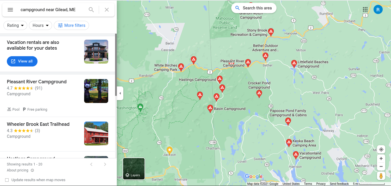
A Google map search won't go much further than where you specify. A search specifying Gilead ME will show more sites in the Evans Notch area. If your trip is going to continue into ME just tweak your search ...
'
Last edited by BobG; 08-13-21 at 03:55 AM. Reason: change search from Bethel to Gilead
08-13-21, 07:52 AM
#14
Mad bike riding scientist
Join Date: Nov 2004
Location: Denver, CO
Posts: 27,362
Bikes: Some silver ones, a red one, a black and orange one, and a few titanium ones
Mentioned: 152 Post(s)
Tagged: 1 Thread(s)
Quoted: 6219 Post(s)
Liked 4,218 Times
in
2,365 Posts
"Walk in" campsites in this part of New England are usually out of range for bike tourists. Maybe not so out west where you are. You might mt bike into the Rocky Branch shelter but you're not going to bike into the Dry River #3 shelter or Tuckerman Ravine. I don't have the "pro" version of Allstays to click on the sites on your map for specific locations.
Yes, Allstays lists some excess campgrounds but the app allows you to click on the campground and get information for it which includes location information. And the hike-in campsites are clearly marked on the app. As I said, Google, for all the power it does have, is often limited in information for whatever reason. For campsites, Allstays is a much better tool. I can�t say anything about the others as I�ve only ever used Allstays.
__________________
Stuart Black
Plan Epsilon Around Lake Michigan in the era of Covid
Old School�When It Wasn�t Ancient bikepacking
Gold Fever Three days of dirt in Colorado
Pokin' around the Poconos A cold ride around Lake Erie
Dinosaurs in Colorado A mountain bike guide to the Purgatory Canyon dinosaur trackway
Solo Without Pie. The search for pie in the Midwest.
Picking the Scablands. Washington and Oregon, 2005. Pie and spiders on the Columbia River!
Stuart Black
Plan Epsilon Around Lake Michigan in the era of Covid
Old School�When It Wasn�t Ancient bikepacking
Gold Fever Three days of dirt in Colorado
Pokin' around the Poconos A cold ride around Lake Erie
Dinosaurs in Colorado A mountain bike guide to the Purgatory Canyon dinosaur trackway
Solo Without Pie. The search for pie in the Midwest.
Picking the Scablands. Washington and Oregon, 2005. Pie and spiders on the Columbia River!
08-15-21, 06:03 PM
#15
Senior Member
The map should also show Burns Lake Campground, Israel's River Camp, a large campground in Goreham, on Rte 2 near the Maine line, and the Appalachian trail. Just campgrounds I happen to have been at
08-15-21, 07:32 PM
#16
Senior Member
I deleted a recent post I made in reply to cyccommute. The thread was getting too cluttered with my screen shots! Cycco, you can read the email version if you get notifications.
Last edited by BobG; 08-16-21 at 05:41 AM.
08-16-21, 03:59 PM
#17
Senior Member
Good Point. I guess I was misled by the map extending beyond the search area. My old fashioned searches were related to the XNHAT and what camping could be found. Burns Lake was closed last year. Does the app pay attention to state lines, or just to distance?
08-17-21, 04:04 AM
#18
Senior Member
Short answer? It has a mind of its own!
It seems to be most accurate within one state but will only go so far in distance if you specify a town. I did a search from Gilead ME (near the state line) to see how many camps it would find in the Evans Notch area and it showed Hastings (ME), Wild River (NH) and The Basin (NH) among others. See screenshot back at post 13. A search from Jackson NH woud not show any camps in ME but showed both camps in NH, a search from Bethel ME would not show any in NH.
The above will appear with big red pins but if you zoom, zoom, zoom until you're right on top of a camp outside of your search zone, it will pop into view with a green pin. Here's your (closed) Burn's Lake Campground that was hidden on my above map!

Had I used Whitefield NH for my search zone Burns Lake would appear automatically with a red pin before zooming in ...

It seems to be most accurate within one state but will only go so far in distance if you specify a town. I did a search from Gilead ME (near the state line) to see how many camps it would find in the Evans Notch area and it showed Hastings (ME), Wild River (NH) and The Basin (NH) among others. See screenshot back at post 13. A search from Jackson NH woud not show any camps in ME but showed both camps in NH, a search from Bethel ME would not show any in NH.
The above will appear with big red pins but if you zoom, zoom, zoom until you're right on top of a camp outside of your search zone, it will pop into view with a green pin. Here's your (closed) Burn's Lake Campground that was hidden on my above map!
Had I used Whitefield NH for my search zone Burns Lake would appear automatically with a red pin before zooming in ...
Last edited by BobG; 08-17-21 at 06:53 AM.
08-17-21, 09:15 AM
#19
Mad bike riding scientist
Join Date: Nov 2004
Location: Denver, CO
Posts: 27,362
Bikes: Some silver ones, a red one, a black and orange one, and a few titanium ones
Mentioned: 152 Post(s)
Tagged: 1 Thread(s)
Quoted: 6219 Post(s)
Liked 4,218 Times
in
2,365 Posts
That�s the problem I have with Google Maps. It seems to decide what is needed and doesn�t give you options. Why doesn�t it give the campgrounds across the state line? Why doesn�t it give the campgrounds around Whitefield? Your search seems to be centered on Jackson. The search field seems have a radius of 15 miles. And, again, seems to leave out several campgrounds. If you are in route, a search circle of 30 miles is useful but for planning purposes, Allstays gives more options with a wider search circle for start of the day distance planning. It�s more reliable with more options covering a wider area. Yes, there are sites that may not be accessible to bicyclists but it�s better to have too much information to sort through then too little.
__________________
Stuart Black
Plan Epsilon Around Lake Michigan in the era of Covid
Old School�When It Wasn�t Ancient bikepacking
Gold Fever Three days of dirt in Colorado
Pokin' around the Poconos A cold ride around Lake Erie
Dinosaurs in Colorado A mountain bike guide to the Purgatory Canyon dinosaur trackway
Solo Without Pie. The search for pie in the Midwest.
Picking the Scablands. Washington and Oregon, 2005. Pie and spiders on the Columbia River!
Stuart Black
Plan Epsilon Around Lake Michigan in the era of Covid
Old School�When It Wasn�t Ancient bikepacking
Gold Fever Three days of dirt in Colorado
Pokin' around the Poconos A cold ride around Lake Erie
Dinosaurs in Colorado A mountain bike guide to the Purgatory Canyon dinosaur trackway
Solo Without Pie. The search for pie in the Midwest.
Picking the Scablands. Washington and Oregon, 2005. Pie and spiders on the Columbia River!
08-17-21, 07:30 PM
#20
Senior Member
Stuart- I got curious about Allstays and paid $10 for the mobile app just so I could play with it. I think you told me about it years ago on this forum, thanks. Before I just used the free desktop version that listed camps by state. The app is indeed a pretty useful tool. I do wish they'd tweak it to separate drive-in USFS camps from the backcountry. Their contrast is a bit hazy on a mobile screen and can be hard to see the roads when you zoom in to know if the pin drop is on the road or in the woods. Yes, I know, click on it an you learn more, Google does that too. I have no problem updating camps on the fly. All I need is 30 seconds to type (I'm slow) and an internet connection (no smart phone). I do enjoy all of your posts, even when we disagree!
