


AZ Hwy60 Claypool Tunnel
 04-14-23, 04:22 AM
#1
Palmer
Thread Starter

Join Date: Mar 2007
Location: Parts Unknown
Posts: 8,627
Bikes: Mike Melton custom, Alex Moulton AM, Dahon Curl
Mentioned: 37 Post(s)
Tagged: 0 Thread(s)
Quoted: 1670 Post(s)
Liked 1,825 Times
in
1,062 Posts
AZ Hwy60 Claypool Tunnel
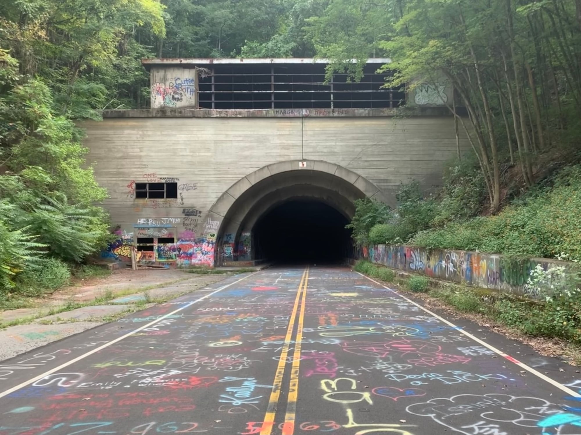
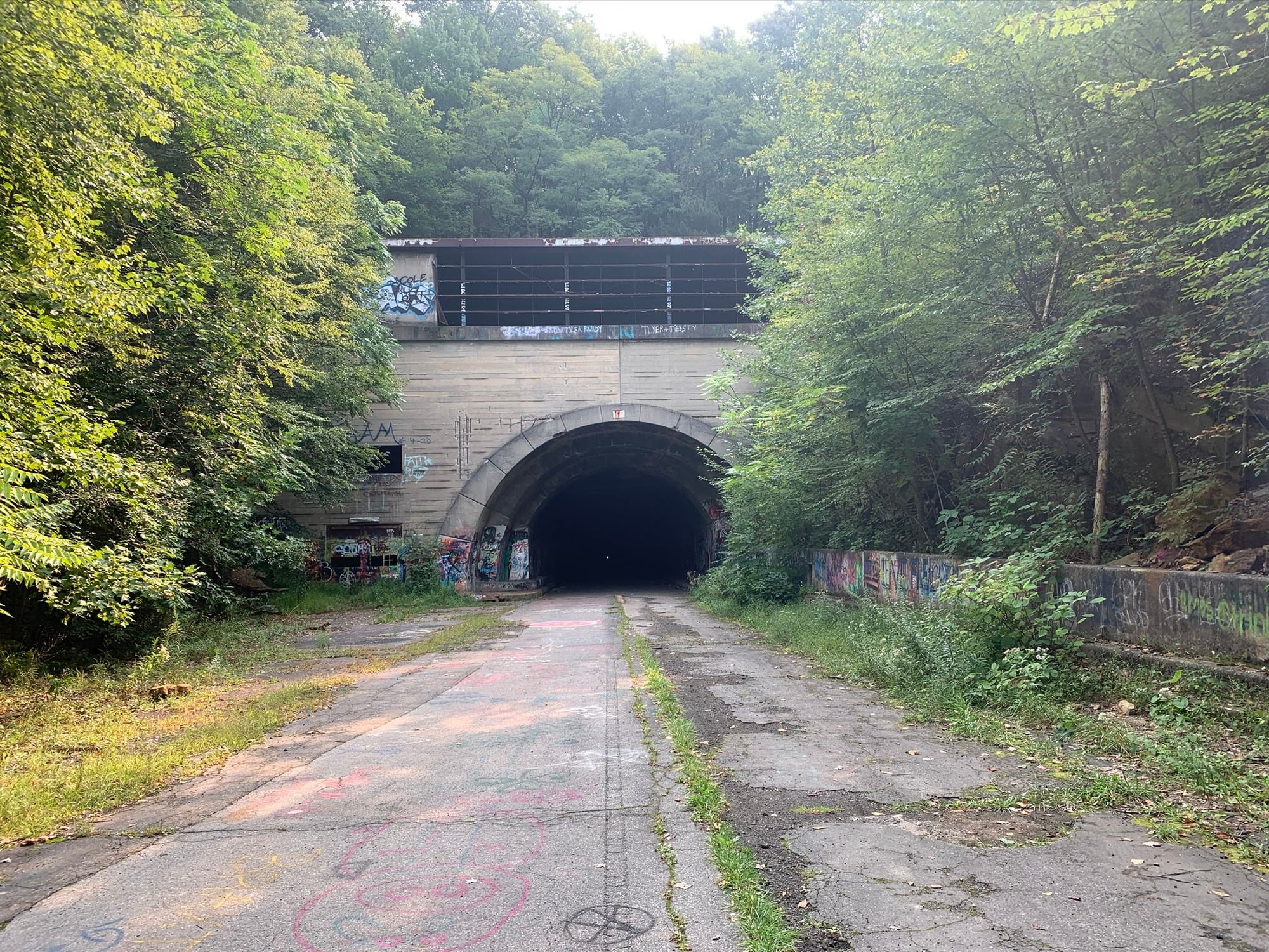
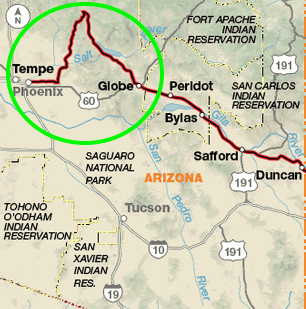
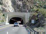
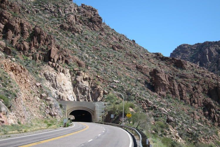
East of Superior: clutch your St. Christopher's medallion and ride through the Queen Creek Tunnel, or take the 120-mile detour all the way up through Jake's Corner?
Or...is the 100-year-old, abandoned Claypool Tunnel passable?
The definitive answer:
Hmph. Maybe a little hike-n-bike, but looks doable...and isn't even against the rules!
Or...is the 100-year-old, abandoned Claypool Tunnel passable?
The definitive answer:
Hmph. Maybe a little hike-n-bike, but looks doable...and isn't even against the rules!
Last edited by tcs; 04-14-23 at 04:41 AM.

Likes For tcs:
04-14-23, 09:28 AM
#2

Mad bike riding scientist

Join Date: Nov 2004
Location: Denver, CO
Posts: 27,366
Bikes: Some silver ones, a red one, a black and orange one, and a few titanium ones
Mentioned: 152 Post(s)
Tagged: 1 Thread(s)
Quoted: 6219 Post(s)
Liked 4,220 Times
in
2,367 Posts
I just…like last night…saw a youtube on this old section of US60. He walks the whole thing which my wife noticed would be easier if he had used a mountain bike but you do get to see the route. Looks bikeable.
__________________
Stuart Black
Plan Epsilon Around Lake Michigan in the era of Covid
Old School�When It Wasn�t Ancient bikepacking
Gold Fever Three days of dirt in Colorado
Pokin' around the Poconos A cold ride around Lake Erie
Dinosaurs in Colorado A mountain bike guide to the Purgatory Canyon dinosaur trackway
Solo Without Pie. The search for pie in the Midwest.
Picking the Scablands. Washington and Oregon, 2005. Pie and spiders on the Columbia River!
 04-14-23, 11:43 AM
#3
Cantilever believer

Join Date: Nov 2021
Location: Phoenix, AZ
Posts: 1,565
Mentioned: 5 Post(s)
Tagged: 0 Thread(s)
Quoted: 536 Post(s)
Liked 1,839 Times
in
832 Posts
I've seen the old US 60 / 70 alignment many times while riding or driving that segment of highway. In the 1980s it wasn't a bad road to ride (other than the numerous steep grades), but in the early 1990s the local ADOT district restriped the road to add passing lanes and eliminated the usable shoulder along much of the highway. There have been subsequent policy changes to discourage that practice, but the installed lanes aren't going to be removed, especially with traffic volumes increasing, including heavy trucks.
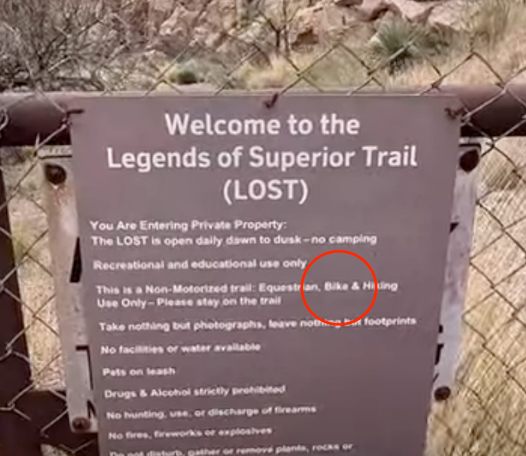
Decades ago, when I tried to access that trail, there were locked gates and NO TRESPASSING signs installed by the mine. I'm happy to see that the mine is now more cooperative.
This trail bypasses the first part of the climb through Queen Creek Canyon and the 1952 tunnel, but ends not far afterward, and there are many miles of shoulder-deprived US 60 between the end of the trail and Miami. There are other segments of bypassed highway farther east, but these segments are discontinuous and obliterated by the current alignment in most places.
__________________
Richard C. Moeur, PE - Phoenix AZ, USA
https://www.richardcmoeur.com/bikestuf.html
Richard C. Moeur, PE - Phoenix AZ, USA
https://www.richardcmoeur.com/bikestuf.html
Likes For RCMoeur:
04-14-23, 01:46 PM
#4
Senior Member
Join Date: Jan 2010
Posts: 39,249
Mentioned: 211 Post(s)
Tagged: 1 Thread(s)
Quoted: 18421 Post(s)
Liked 15,568 Times
in
7,334 Posts
Go for it!
I have ridden the more modern tunnels of the abandoned stretch of the PA Turnpike. Despite being abandoned in the 60s, the surfaces inside both aren�t bad. The longer of the two is over a mile, and due to the crown, you literally can�t see the light at the end.
The two west portals. The first looks well paved because that stretch was used to train snow plow and other large vehicle operators.
One of the two was a filming location for �The Road�� starring Viggo Mortensen.
Likes For indyfabz:
04-14-23, 01:55 PM
#5
bicycle tourist
If I remember correctly, US 60 used to be the Adventure Cycling Route and I went through that tunnel back in 2001.
My journal for that day says - " As you can see at left, at one point the route became narrow enough to require a short tunnel. Cars honking in the tunnel were a bit disorienting, but otherwise wasn't too bad. Climb was slow, though feels like I've been getting stronger for these sorts of routes, or the hills are getting smaller."
I expect the roads have only gotten busier, in the 22 years since so seems like it would be pretty hazardous now.
Likes For mev:
04-14-23, 03:40 PM
#6
Palmer
Thread Starter
Join Date: Mar 2007
Location: Parts Unknown
Posts: 8,627
Bikes: Mike Melton custom, Alex Moulton AM, Dahon Curl
Mentioned: 37 Post(s)
Tagged: 0 Thread(s)
Quoted: 1670 Post(s)
Liked 1,825 Times
in
1,062 Posts
 04-14-23, 08:38 PM
#7
Cantilever believer
Join Date: Nov 2021
Location: Phoenix, AZ
Posts: 1,565
Mentioned: 5 Post(s)
Tagged: 0 Thread(s)
Quoted: 536 Post(s)
Liked 1,839 Times
in
832 Posts
If I remember correctly, US 60 used to be the Adventure Cycling Route and I went through that tunnel back in 2001.
My journal for that day says - " As you can see at left, at one point the route became narrow enough to require a short tunnel. Cars honking in the tunnel were a bit disorienting, but otherwise wasn't too bad. Climb was slow, though feels like I've been getting stronger for these sorts of routes, or the hills are getting smaller."
I expect the roads have only gotten busier, in the 22 years since so seems like it would be pretty hazardous now.
My journal for that day says - " As you can see at left, at one point the route became narrow enough to require a short tunnel. Cars honking in the tunnel were a bit disorienting, but otherwise wasn't too bad. Climb was slow, though feels like I've been getting stronger for these sorts of routes, or the hills are getting smaller."
I expect the roads have only gotten busier, in the 22 years since so seems like it would be pretty hazardous now.
US Bicycle Route 90, even though it generally parallels the Southern Tier, instead goes from Phoenix to Tucson and then to southeast Arizona before heading to New Mexico. It made sense for the east-west USBR to serve the two largest metro areas, while the ST route tries to follow its traditional alignment where it can, especially given the support that the towns along US 70 in eastern Arizona give to having the Southern Tier run along their main streets.
There are long term plans to upgrade US 60 between Superior and Globe but they're currently unscheduled and unfunded. An upgraded roadway would very likely have full-width shoulders, given its past history as a popular bicycle route.
Disclosure: I served as the chair of the AASHTO Task Force on US Bicycle Routes from 2003 to 2017, and advised ACA on their routes in the state upon request.
__________________
Richard C. Moeur, PE - Phoenix AZ, USA
https://www.richardcmoeur.com/bikestuf.html
Richard C. Moeur, PE - Phoenix AZ, USA
https://www.richardcmoeur.com/bikestuf.html
04-14-23, 10:44 PM
#8
Cantilever believer
Join Date: Nov 2021
Location: Phoenix, AZ
Posts: 1,565
Mentioned: 5 Post(s)
Tagged: 0 Thread(s)
Quoted: 536 Post(s)
Liked 1,839 Times
in
832 Posts
(I will neither confirm nor deny that I have partaken in such an activity...)

__________________
Richard C. Moeur, PE - Phoenix AZ, USA
https://www.richardcmoeur.com/bikestuf.html
Richard C. Moeur, PE - Phoenix AZ, USA
https://www.richardcmoeur.com/bikestuf.html
04-14-23, 11:58 PM
#9
bicycle tourist
Small thumbnail photo I took that day (March 16th, 2001):
 04-16-23, 09:44 AM
#10
Junior Member
I went through the tunnel 10 years ago. I didn't find it too bad. I switched my rear flasher on, waited until there was no uphill traffic in sight then changed up a couple of gears and gave it welly for two minutes until I was out the other side back into the sunshine.
Going on east I didn't find the road too much of a problem. I,d do it again rather than detour 120 miles
.
Going on east I didn't find the road too much of a problem. I,d do it again rather than detour 120 miles
.
Likes For irc:
04-16-23, 10:34 AM
#11
Junior Member

I did east-to-west in 2009 (without really knowing anything about US-60 in advance), and it still sticks in my memory as one of the most-dangerous sections of riding I've ever done (the blind hilly curves filled with give-no-****s logging trucks of the Sierra Cascades route near Quincy, CA is its only competition in my memory). Of course the fact that the road was under construction at the time was probably a big factor (though not the only one). And traffic/weather/random-mood on a particular day can turn one person's nightmare into another person's pleasant ride. The tunnel itself was a non-issue (partly because I went through in the downhill direction, I'm sure), it was the "heavy traffic with no place for it to safely go around you" on all the other sections of the road that was the main problem.
From my journal:
"Then I had to go up and down another 1500 ft. worth of hill over an 18 mile stretch of the fast and busy US-60, a test I wouldn�t wish on my worst enemy. It would have been difficult under normal conditions, but adding four miles of construction at the final stretch to the summit made it one of the most hair-raising and stressful rides I�ve ever done. I had to pull out every trick I knew, including off-roading, riding on the shoulder on the wrong side of the road, pulling off to let barrelling trucks pass, or simply gunning it over short stretches to get to the next safe spot. The only thing I had gong in my favor was that it wasn�t raining.
Until I crested the summit, and then the rain started to fall again. Ah, noon in Arizona on Memorial Day weekend, and it�s 59 degrees and I�m soaking wet. Even though there was no construction on the downhill, it was still difficult because whenever a passing lane would appear in the oncoming direction, it would eliminate the shoulder on my side. And the road was so busy and full of trucks that there would always be a line of cars jumping into the oncoming passing lane, giving no chance for vehicles on my side to slide around me. I�ve seen people debate the use of a rear-view mirror for bike touring, which makes no sense to me. At least on a road like this, there is no debate: without my mirror, my chances of making it through alive would have been rather small.
Despite all that, there were a couple moments where I could see through the raindrops on my glasses that I was descending through a rather spectacular canyon. If it wasn�t raining, if my life wasn�t hanging in the balance, and if I hadn�t just been through some of the most awe-inspiring canyons in the world over the last few weeks, I might have snapped a photo or two.
At one point, I went through a tunnel, and when I came out the other end, the sun was shining! Soon after, I eagerly turned off the US-60 nightmare onto the much more pleasant AZ-77. I even stopped and optimistically took off my rain jacket, which might give the rest of my clothes a chance to dry out. I cursed myself for an idiot when it started dripping again 10 minutes later, but it soon stopped, and didn�t start again for the rest of the day. Hooray!"
04-16-23, 02:56 PM
#12
Senior Member
I wish I had know about the Claypool Tunnel when I rode Hwy 60 on my ST years ago. I love exploring old abandoned tunnels and highways and hwy 60 there was one of the worst sectios of road I recall riding on tour. I was riding skinny road tires so I might have had to shoulder the bike and gear, but total weight (bike and gear) was 38# plus food and water. So it would have probably been doable it I didn't have to carry the bike the whole way. It looks like some could be ridden, some walked, and maybe some carried.
04-16-23, 03:25 PM
#13
bicycle tourist
I cycled 87 in 2016 when I was heading westbound and came across from Show Low to Payson before taking 87 southbound from Payson to Fountain Hills. It was four lanes and had shoulders but not sure I would put it high on my list of nice roads to cycle. I had the saving grace that I had a majority of downhill cycling. Strava told me ~3000ft of net elevation descent from the Maricopa County line to Fountain Hills - so one would have that gain going the other direction. If I saw that on my maps I'd be tempted to consider a "short cut" of AZ 88.
04-16-23, 04:30 PM
#14
Senior Member

I used to live in Arizona but I've never been to this old stretch of Hwy 60. Going to have to check it out the next time I'm out there. Arizona has a lot of old funky places like this, many tucked way out of the way. Cool state to live.
04-16-23, 04:46 PM
#15
Cantilever believer
Join Date: Nov 2021
Location: Phoenix, AZ
Posts: 1,565
Mentioned: 5 Post(s)
Tagged: 0 Thread(s)
Quoted: 536 Post(s)
Liked 1,839 Times
in
832 Posts
Was AZ 88 considered? From the maps, it looks like this is a smaller road. No shoulders but also more direct than taking the entire detour of 87/188.
I cycled 87 in 2016 when I was heading westbound and came across from Show Low to Payson before taking 87 southbound from Payson to Fountain Hills. It was four lanes and had shoulders but not sure I would put it high on my list of nice roads to cycle. I had the saving grace that I had a majority of downhill cycling. Strava told me ~3000ft of net elevation descent from the Maricopa County line to Fountain Hills - so one would have that gain going the other direction. If I saw that on my maps I'd be tempted to consider a "short cut" of AZ 88.
I cycled 87 in 2016 when I was heading westbound and came across from Show Low to Payson before taking 87 southbound from Payson to Fountain Hills. It was four lanes and had shoulders but not sure I would put it high on my list of nice roads to cycle. I had the saving grace that I had a majority of downhill cycling. Strava told me ~3000ft of net elevation descent from the Maricopa County line to Fountain Hills - so one would have that gain going the other direction. If I saw that on my maps I'd be tempted to consider a "short cut" of AZ 88.
SR 88 from Apache Junction to several miles east of Tortilla Flat used to be a popular cycling route, but is barely 20 ft in overall width and sees heavy pickup and boat trailer traffic most days. A few of these drivers are not always the most considerate in cooperating with cyclists also legally using the road. East of Canyon Lake, the traffic volume drops greatly, and is fun riding, although there is a steady 8% uphill eastbound for miles (this is where I flatted on the front as I hit 60 mph going west as described in another thread).
After the road turns to dirt, it is rather rough going for about 30ish miles. It might be traversable on gravel tires, but isn't all that suitable for road tires, especially if the bike is carrying a self-contained load. Several sections of loose sand and steep grades, and other sections are rocky. Services at the marinas are limited. But all of this for the foreseeable future is moot, as SR 88 has been closed to through traffic since a big landslide in 2019, and there are no specific plans or funds to rebuild or reopen the road, even though it's nominally a state "highway".
https://en.m.wikipedia.org/wiki/Apache_Trail
__________________
Richard C. Moeur, PE - Phoenix AZ, USA
https://www.richardcmoeur.com/bikestuf.html
Richard C. Moeur, PE - Phoenix AZ, USA
https://www.richardcmoeur.com/bikestuf.html
Last edited by RCMoeur; 04-16-23 at 05:09 PM. Reason: (added link to other thread re "how fast")
04-16-23, 04:55 PM
#16
Palmer
Thread Starter
Join Date: Mar 2007
Location: Parts Unknown
Posts: 8,627
Bikes: Mike Melton custom, Alex Moulton AM, Dahon Curl
Mentioned: 37 Post(s)
Tagged: 0 Thread(s)
Quoted: 1670 Post(s)
Liked 1,825 Times
in
1,062 Posts
Mostly washboard gravel when I traversed it a few years back. Dusty, dusty, dusty. The guidebook says the north side of Fish Creek Hill "is not for the faint of heart" & IMO that's charitable (steep, narrow, unpaved & no guardrails). Stunningly beautiful along the lakes, though.
(RC posted while I was typing. ↑ )
(RC posted while I was typing. ↑ )
Last edited by tcs; 04-16-23 at 05:00 PM.
04-16-23, 05:05 PM
#17
Cantilever believer
Join Date: Nov 2021
Location: Phoenix, AZ
Posts: 1,565
Mentioned: 5 Post(s)
Tagged: 0 Thread(s)
Quoted: 536 Post(s)
Liked 1,839 Times
in
832 Posts
The dirt segment of SR 88 is (was) an open-air museum of obsolete roadside barrier types used by the Arizona Highway Department over the past century - painted "road guide" posts, wooden posts with steel cables, steel plate guardrail from the 1920s, half-moon guardrail from the 1940s, and early W-bean from the 1950s. And a few spots where one could go full Wile E. Coyote with nothing but Arizona air between the roadway and a painful plummet. I don't know how much of this was wiped out by the landslide - probably not much, as it's my understanding only a limited length of road disappeared, but in a manner that will take a lot of currently-unavailable money to remedy.
__________________
Richard C. Moeur, PE - Phoenix AZ, USA
https://www.richardcmoeur.com/bikestuf.html
Richard C. Moeur, PE - Phoenix AZ, USA
https://www.richardcmoeur.com/bikestuf.html
06-12-23, 01:28 PM
#18
Senior Member

Join Date: Apr 2006
Location: Washington County, Vermont, USA
Posts: 3,778
Bikes: 1966 Dawes Double Blue, 1976 Raleigh Gran Sport, 1975 Raleigh Sprite 27, 1980 Univega Viva Sport, 1971 Gitane Tour de France, 1984 Lotus Classique, 1976 Motobecane Grand Record
Mentioned: 77 Post(s)
Tagged: 0 Thread(s)
Quoted: 765 Post(s)
Liked 660 Times
in
351 Posts
My friend Phil and I walked our bikes through the old Claypool Tunnel when we rode the Southern Tier in 2017. Nothing to it. A short, easy jaunt. Riding through the newer Queen Creek Tunnel would have been terrifying, I think, mostly because the grade is so steep that I would not have been able to just power through it at good speed..
It was very satisfying to me, because I had scoped out the route on Google Earth before we left, and although it looked perfectly feasible we weren't absolutely sure of it until we got there. It's great when a plan works.
It seems to me that the ACA should make the Claypool option the default route. I suggested that to them but never got a response.
__________________
www.redclovercomponents.com
"Progress might have been all right once, but it has gone on too long."
--Ogden Nash
www.redclovercomponents.com
"Progress might have been all right once, but it has gone on too long."
--Ogden Nash
Likes For jonwvara:
06-13-23, 04:46 AM
#19
Senior Member
My friend Phil and I walked our bikes through the old Claypool Tunnel when we rode the Southern Tier in 2017. Nothing to it. A short, easy jaunt. Riding through the newer Queen Creek Tunnel would have been terrifying, I think, mostly because the grade is so steep that I would not have been able to just power through it at good speed..
It was very satisfying to me, because I had scoped out the route on Google Earth before we left, and although it looked perfectly feasible we weren't absolutely sure of it until we got there. It's great when a plan works.
It seems to me that the ACA should make the Claypool option the default route. I suggested that to them but never got a response.
It was very satisfying to me, because I had scoped out the route on Google Earth before we left, and although it looked perfectly feasible we weren't absolutely sure of it until we got there. It's great when a plan works.
It seems to me that the ACA should make the Claypool option the default route. I suggested that to them but never got a response.
06-13-23, 06:36 AM
#20
Senior Member
Join Date: Apr 2006
Location: Washington County, Vermont, USA
Posts: 3,778
Bikes: 1966 Dawes Double Blue, 1976 Raleigh Gran Sport, 1975 Raleigh Sprite 27, 1980 Univega Viva Sport, 1971 Gitane Tour de France, 1984 Lotus Classique, 1976 Motobecane Grand Record
Mentioned: 77 Post(s)
Tagged: 0 Thread(s)
Quoted: 765 Post(s)
Liked 660 Times
in
351 Posts
I really wish I had known about it when I did the Southern Tour. That was one of the more scarey sections I rememember from my tours and the detour sounds like it would have been a nice diversion. If there had just been a mention that it might be possible I might have looked into it.
Edit: it's easy to get onto the Claypool bypass just before you get to the Queen Creek Tunnel. Follow Rt. 60 out of Superior, over the dramatic arched bridge and on up the steep grade beyond. When you come into sight of the mouth of the Queen Creek Tunnel, there's an obvious and very large gravel pullout on the right. Near the bottom of the pullout--that is, the downhill end of it--there's a sort of drainage swale that heads off downhill. You can easily roll a bike down it. It's only a hundred feet or so to where it empties onto the old road that leads to the abandoned Claypool tunnel. It's not very steep (the old road, not the drainage swale), so you could probably ride it, but the pavement is so old and broken up that it's probably easier to walk.
All of this is fresh in my mind because I walked over the route this past February while on my way to a hiking trip further east.
__________________
www.redclovercomponents.com
"Progress might have been all right once, but it has gone on too long."
--Ogden Nash
www.redclovercomponents.com
"Progress might have been all right once, but it has gone on too long."
--Ogden Nash
Last edited by jonwvara; 06-13-23 at 07:02 PM.
