


Richmond/San Rafael Bridge Bike Lane
 07-23-23, 02:34 PM
#1
Senior Member
Thread Starter

Richmond/San Rafael Bridge Bike Lane
Not sure how this plan would work
https://abc7news.com/richmond-san-rafael-bridge-new-lane-traffic-upper-deck/13515160/
Richmond San Rafael Bridge
https://abc7news.com/richmond-san-rafael-bridge-new-lane-traffic-upper-deck/13515160/
Richmond San Rafael Bridge
 07-23-23, 04:30 PM
#2

Senior Member
Join Date: Apr 2009
Location: New Rochelle, NY
Posts: 38,725
Bikes: too many bikes from 1967 10s (5x2)Frejus to a Sumitomo Ti/Chorus aluminum 10s (10x2), plus one non-susp mtn bike I use as my commuter
Mentioned: 140 Post(s)
Tagged: 1 Thread(s)
Quoted: 5793 Post(s)
Liked 2,584 Times
in
1,432 Posts
I can't comment because of lack of detailed knowledge about this bridge.
But I'm a bit confused by the report referencing a 3rd bike lane. Also, while the photos show a 4 lane roadway, there's references to an upper deck. So, are there really 2 bike lanes now, and if there are two decks, what is the total capacity and how is it used?
In any case, if I remember my advocacy history, way back when California was a pioneer enacting a law that mandated preserving bike access wherever it existed if/when roads were modified. So, I would assume that some amount of advocacy may ensure that whatever plan is used meets both the letter and spirit of that law.
Otherwise, I'm a big fan of zippers to meet rush hour capacity needs rather than expansion as a short term solution. But the long term answer that best meets sustainability and quality of life needs is changes to zoning and regional planning to eliminate "tidal" ebb and flow daily commutes. If we desegregate jobs and homes, more people could be working closer to home saving everybody time, energy and money.
__________________
FB
Chain-L site
An ounce of diagnosis is worth a pound of cure.
Just because I'm tired of arguing, doesn't mean you're right.
�One accurate measurement is worth a thousand expert opinions� - Adm Grace Murray Hopper - USN
WARNING, I'm from New York. Thin skinned people should maintain safe distance.
FB
Chain-L site
An ounce of diagnosis is worth a pound of cure.
Just because I'm tired of arguing, doesn't mean you're right.
�One accurate measurement is worth a thousand expert opinions� - Adm Grace Murray Hopper - USN
WARNING, I'm from New York. Thin skinned people should maintain safe distance.
 07-31-23, 03:28 PM
#3
Senior Member
Join Date: Sep 2008
Posts: 5,201
Mentioned: 0 Post(s)
Tagged: 0 Thread(s)
Quoted: 137 Post(s)
Likes: 0
Liked 81 Times
in
64 Posts
Richmond SanRafael Bridge will never be a well used bike route. It’s gorgeous and windy as hell but anyone commuting will be going much farther than Pt Richmond or San Quentin.
07-31-23, 09:11 PM
#4
Friendship is Magic

Join Date: Nov 2010
Location: Sacramento, CA
Posts: 22,985
Bikes: old ones
Mentioned: 304 Post(s)
Tagged: 0 Thread(s)
Quoted: 26425 Post(s)
Liked 10,381 Times
in
7,209 Posts
.
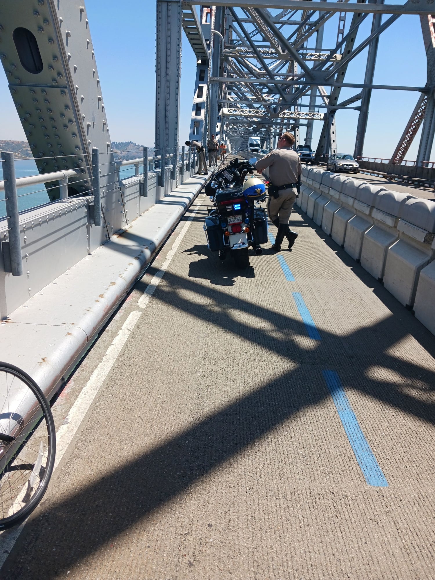
There was an incident about a week ago, where someone cycled out on the bike lane on the upper span, then got off his bike and climbed down to the lower.
It was apparently someone threatening to jump, so they shut down the entire lower (eastbound) lanes for maybe 17 hours.
That probably did not help with getting people to support the whole bicycle access over the Richmond bridge thing, even though a motorist could do the same thing.
https://sfist.com/2023/07/25/richmon...e-closure-and/
__________________
10-20-23, 11:47 PM
#5
Crawlin' up, flyin' down

Join Date: Jan 2006
Location: Democratic Peoples' Republic of Berkeley
Posts: 5,658
Bikes: 1967 Paramount; 1982-ish Ron Cooper; 1978 Eisentraut "A"; two mid-1960s Cinelli Speciale Corsas; and others in various stages of non-rideability.
Mentioned: 40 Post(s)
Tagged: 0 Thread(s)
Quoted: 1027 Post(s)
Liked 2,531 Times
in
1,059 Posts
Not sure how this plan would work
https://abc7news.com/richmond-san-ra...deck/13515160/
Richmond San Rafael Bridge
https://abc7news.com/richmond-san-ra...deck/13515160/
Richmond San Rafael Bridge
I can't comment because of lack of detailed knowledge about this bridge.
But I'm a bit confused by the report referencing a 3rd bike lane. Also, while the photos show a 4 lane roadway, there's references to an upper deck. So, are there really 2 bike lanes now, and if there are two decks, what is the total capacity and how is it used?
In any case, if I remember my advocacy history, way back when California was a pioneer enacting a law that mandated preserving bike access wherever it existed if/when roads were modified. So, I would assume that some amount of advocacy may ensure that whatever plan is used meets both the letter and spirit of that law.
Otherwise, I'm a big fan of zippers to meet rush hour capacity needs rather than expansion as a short term solution. But the long term answer that best meets sustainability and quality of life needs is changes to zoning and regional planning to eliminate "tidal" ebb and flow daily commutes. If we desegregate jobs and homes, more people could be working closer to home saving everybody time, energy and money.
But I'm a bit confused by the report referencing a 3rd bike lane. Also, while the photos show a 4 lane roadway, there's references to an upper deck. So, are there really 2 bike lanes now, and if there are two decks, what is the total capacity and how is it used?
In any case, if I remember my advocacy history, way back when California was a pioneer enacting a law that mandated preserving bike access wherever it existed if/when roads were modified. So, I would assume that some amount of advocacy may ensure that whatever plan is used meets both the letter and spirit of that law.
Otherwise, I'm a big fan of zippers to meet rush hour capacity needs rather than expansion as a short term solution. But the long term answer that best meets sustainability and quality of life needs is changes to zoning and regional planning to eliminate "tidal" ebb and flow daily commutes. If we desegregate jobs and homes, more people could be working closer to home saving everybody time, energy and money.
A few years ago, one of the upper deck lanes was cordoned off to make a two-way bike lane after a long administrative battle, one of the biggest bicycle advocacy victories in the area. The separator looks kind of like a "zipper," but it is stationary, not moveable. So now there are two westbound lanes for cars with a permanent lane for bikes going both ways, while there are still three eastbound lanes for cars. The proposal is basically to get rid of the bike lane and return to the status quo ante.
I hope that clears up the confusion. The article was not particularly well-written, as is the norm with mainstream reporting on bike-related issues.
__________________
"I'm in shape -- round is a shape." Andy Rooney
"I'm in shape -- round is a shape." Andy Rooney
10-22-23, 11:17 AM
#6
Senior Member
Join Date: Jun 2002
Location: Montreal, Quebec
Posts: 5,930
Mentioned: 16 Post(s)
Tagged: 0 Thread(s)
Quoted: 1820 Post(s)
Liked 1,696 Times
in
976 Posts
The San Rafael is a double-decker bridge. Both decks are three lanes wide. The upper deck is westbound, the lower deck eastbound. The westbound approach (Richmond side) has four lanes of freeway until you get pretty close to the bridge, the eastbound approach (San Rafael/San Quentin side) has two.
A few years ago, one of the upper deck lanes was cordoned off to make a two-way bike lane after a long administrative battle, one of the biggest bicycle advocacy victories in the area. The separator looks kind of like a "zipper," but it is stationary, not moveable. So now there are two westbound lanes for cars with a permanent lane for bikes going both ways, while there are still three eastbound lanes for cars. The proposal is basically to get rid of the bike lane and return to the status quo ante.
I hope that clears up the confusion. The article was not particularly well-written, as is the norm with mainstream reporting on bike-related issues.
10-22-23, 12:02 PM
#7
Crawlin' up, flyin' down
Join Date: Jan 2006
Location: Democratic Peoples' Republic of Berkeley
Posts: 5,658
Bikes: 1967 Paramount; 1982-ish Ron Cooper; 1978 Eisentraut "A"; two mid-1960s Cinelli Speciale Corsas; and others in various stages of non-rideability.
Mentioned: 40 Post(s)
Tagged: 0 Thread(s)
Quoted: 1027 Post(s)
Liked 2,531 Times
in
1,059 Posts
To be clear, no lane barriers are moved - ever. The bike lane on the upper (westbound) level is for bikes going both ways - pedestrians, too, although not many of those. The barrier separating bikes from westbound cars is stationary. The only lane changes are in the eastbound direction/lower deck, controlled solely by lights (which are sometime ignored), and bikes are never on the lower deck.
I do not know why the upper deck/westbound direction was chosen for the bike lane. It certainly makes for a more pleasant biking experience than being on the lower deck, which feels a lot like a tunnel. It is significantly further from the east end of the bridge back to I-80 than from the west end of the bridge back to US 101. which means it takes a much bigger backup westbound to back onto I-80 than for an eastbound backup onto US 101. (Both I-80 and US 101 are major traffic arteries at all times, especially commute times.) That may have had something to do with choosing to put the bike lane on the westbound upper deck.
I hope this better explains the lay-out.
As for removing the bike lane, there is another player not mentioned so far - the MTC (Metropolitan Transportation Commission. It's a regional governmental agency that has great deal to say about where traffic and transit money from the state and federal governments goes in the Bay Area. In the recent past, the MTC has been very pro-bike-lane on the San Rafael Bridge. Indeed, the bike lane was added mainly because the MTC refused to approve continued funding for something or other Marin County mucky-mucks wanted unless the bike lane went in. I do not know whether such sentiments still prevail on the MTC, but I would not be surprised if they did. The MTC has pretty much always seen itself as the regional-focused grown-up keeping the various local government children from getting away with temper tantrums. With its power of the purse, the MTC most likely will, as a practical matter, have the final say as to whether the bike lane stays or goes. My guess is it will stay.
__________________
"I'm in shape -- round is a shape." Andy Rooney
"I'm in shape -- round is a shape." Andy Rooney
10-23-23, 07:58 AM
#8
Senior Member
Join Date: Aug 2009
Location: Minneapolis
Posts: 5,752
Bikes: 2022 Salsa Beargrease Carbon Deore 11, 2020 Salsa Warbird GRX 600, 2020 Canyon Ultimate CF SLX disc 9.0 Di2, 2020 Catrike Eola, 2016 Masi cxgr, 2011, Felt F3 Ltd, 2010 Trek 2.1, 2009 KHS Flite 220
Mentioned: 20 Post(s)
Tagged: 0 Thread(s)
Quoted: 4393 Post(s)
Liked 3,016 Times
in
1,865 Posts
I understand why that route is little-used by cyclists - as already said, it's a long windy ride and there are few who would make it part of their regular commute.
The real problem is that there's no way to ride from the east bay to the S.F. peninsula on the Bay Bridge. Such a route would be used by many.
But presently, the only way to get from the east bay to the western counties (S.F./Marin) is to use the San Rafael/Richmond bridge (or to go all the way around the bay, which would be a whole-day's journey).
10-23-23, 08:04 AM
#9
Senior Member
Join Date: Aug 2009
Location: Minneapolis
Posts: 5,752
Bikes: 2022 Salsa Beargrease Carbon Deore 11, 2020 Salsa Warbird GRX 600, 2020 Canyon Ultimate CF SLX disc 9.0 Di2, 2020 Catrike Eola, 2016 Masi cxgr, 2011, Felt F3 Ltd, 2010 Trek 2.1, 2009 KHS Flite 220
Mentioned: 20 Post(s)
Tagged: 0 Thread(s)
Quoted: 4393 Post(s)
Liked 3,016 Times
in
1,865 Posts
I understand why that route is little-used by cyclists - as already said, it's a long windy ride and there are few who would make it part of their regular commute.
The real problem is that there's no way to ride from the east bay to the S.F. peninsula on the Bay Bridge. Such a route would be used by many.
But presently, the only way to get from the east bay to the western counties (S.F./Marin) is to use the San Rafael/Richmond bridge (or to go all the way around the bay, which would be a whole-day's journey).
The real problem is that there's no way to ride from the east bay to the S.F. peninsula on the Bay Bridge. Such a route would be used by many.
But presently, the only way to get from the east bay to the western counties (S.F./Marin) is to use the San Rafael/Richmond bridge (or to go all the way around the bay, which would be a whole-day's journey).
10-23-23, 09:49 AM
#10
Perceptual Dullard
Join Date: Sep 2009
Posts: 2,421
Mentioned: 36 Post(s)
Tagged: 0 Thread(s)
Quoted: 919 Post(s)
Liked 1,156 Times
in
494 Posts
The San Rafael is a double-decker bridge. Both decks are three lanes wide. The upper deck is westbound, the lower deck eastbound. The westbound approach (Richmond side) has four lanes of freeway until you get pretty close to the bridge, the eastbound approach (San Rafael/San Quentin side) has two.
A few years ago, one of the upper deck lanes was cordoned off to make a two-way bike lane after a long administrative battle, one of the biggest bicycle advocacy victories in the area. The separator looks kind of like a "zipper," but it is stationary, not moveable. So now there are two westbound lanes for cars with a permanent lane for bikes going both ways, while there are still three eastbound lanes for cars. The proposal is basically to get rid of the bike lane and return to the status quo ante.
I hope that clears up the confusion. The article was not particularly well-written, as is the norm with mainstream reporting on bike-related issues.
A few years ago, one of the upper deck lanes was cordoned off to make a two-way bike lane after a long administrative battle, one of the biggest bicycle advocacy victories in the area. The separator looks kind of like a "zipper," but it is stationary, not moveable. So now there are two westbound lanes for cars with a permanent lane for bikes going both ways, while there are still three eastbound lanes for cars. The proposal is basically to get rid of the bike lane and return to the status quo ante.
I hope that clears up the confusion. The article was not particularly well-written, as is the norm with mainstream reporting on bike-related issues.
10-29-23, 11:37 AM
#11
Perceptual Dullard
Join Date: Sep 2009
Posts: 2,421
Mentioned: 36 Post(s)
Tagged: 0 Thread(s)
Quoted: 919 Post(s)
Liked 1,156 Times
in
494 Posts
A few years ago, one of the upper deck lanes was cordoned off to make a two-way bike lane after a long administrative battle, one of the biggest bicycle advocacy victories in the area. The separator looks kind of like a "zipper," but it is stationary, not moveable. So now there are two westbound lanes for cars with a permanent lane for bikes going both ways, while there are still three eastbound lanes for cars. The proposal is basically to get rid of the bike lane and return to the status quo ante.
10-29-23, 06:32 PM
#12
Crawlin' up, flyin' down
Join Date: Jan 2006
Location: Democratic Peoples' Republic of Berkeley
Posts: 5,658
Bikes: 1967 Paramount; 1982-ish Ron Cooper; 1978 Eisentraut "A"; two mid-1960s Cinelli Speciale Corsas; and others in various stages of non-rideability.
Mentioned: 40 Post(s)
Tagged: 0 Thread(s)
Quoted: 1027 Post(s)
Liked 2,531 Times
in
1,059 Posts
"A few years ago" means 46 years ago, in 1977. From the bridge's opening in 1956 to 1977, the bridge had 3 lanes in each direction, top and bottom. The standard width for traffic lanes back then was narrower than now (for example, the Bay Bridge used to have six lanes on the top deck; now it has five). In 1977, the rightmost lane of the upper deck was taken out of service to be used for a cross-bay pipeline to supply Marin Co. with water. (BTW, all of Treasure Island and Yerba Buena Island is served by a single 9" water pipe across the western span of the Bay Bridge; when the eastern span of the BB was rebuilt, no secondary pipe was added from the Oakland side). In 1982, the pipeline was removed but the lane was converted into a wide maintenance and emergency lane, as was done on the bottom deck so the bridge was two lanes in each direction. That was the status until 2019, when the top deck lane was converted from a maintenance and emergency lane to a bike lane.
")
__________________
"I'm in shape -- round is a shape." Andy Rooney
"I'm in shape -- round is a shape." Andy Rooney
11-09-23, 10:32 AM
#14
Senior Member
Join Date: Mar 2007
Location: SF Bay Area, East bay
Posts: 7,663
Bikes: Miyata 618 GT, Marinoni, Kestral 200 2002 Trek 5200, KHS Flite, Koga Miyata, Schwinn Spitfire 5, Mondia Special, Univega Alpina, Miyata team Ti, Santa Cruz Highball
Mentioned: 53 Post(s)
Tagged: 0 Thread(s)
Quoted: 1611 Post(s)
Liked 2,593 Times
in
1,225 Posts
.
There was an incident about a week ago, where someone cycled out on the bike lane on the upper span, then got off his bike and climbed down to the lower.
It was apparently someone threatening to jump, so they shut down the entire lower (eastbound) lanes for maybe 17 hours.
That probably did not help with getting people to support the whole bicycle access over the Richmond bridge thing, even though a motorist could do the same thing.
https://sfist.com/2023/07/25/richmon...e-closure-and/
 11-10-23, 10:25 AM
#15
Senior Member
Join Date: Mar 2007
Location: SF Bay Area, East bay
Posts: 7,663
Bikes: Miyata 618 GT, Marinoni, Kestral 200 2002 Trek 5200, KHS Flite, Koga Miyata, Schwinn Spitfire 5, Mondia Special, Univega Alpina, Miyata team Ti, Santa Cruz Highball
Mentioned: 53 Post(s)
Tagged: 0 Thread(s)
Quoted: 1611 Post(s)
Liked 2,593 Times
in
1,225 Posts
Interesting how the car lane advocates promote the bike lane as a rich, elite, perk. It really opens up the options for inner city Richmond residents who are getting into bicycling.
https://www.eventbrite.com/e/4yr-ann...s-732212977727
https://www.eventbrite.com/e/4yr-ann...s-732212977727
Last edited by curbtender; 11-10-23 at 10:34 AM.
11-14-23, 10:48 AM
#16
Senior Member
Join Date: Mar 2007
Location: SF Bay Area, East bay
Posts: 7,663
Bikes: Miyata 618 GT, Marinoni, Kestral 200 2002 Trek 5200, KHS Flite, Koga Miyata, Schwinn Spitfire 5, Mondia Special, Univega Alpina, Miyata team Ti, Santa Cruz Highball
Mentioned: 53 Post(s)
Tagged: 0 Thread(s)
Quoted: 1611 Post(s)
Liked 2,593 Times
in
1,225 Posts
