


I made a map that shows all of the paved/gravel roads!
 02-20-24, 11:45 AM
#1
Senior Member
Thread Starter
I made a map that shows all of the paved/gravel roads!
Hello,
I'm part of the team of three roommates who've been developing a completely free alternative cycling routing service, similar to Strava's route builder/Kommot/RideWithGPS over the past year, https://sherpa-map.com.
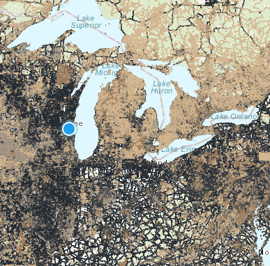
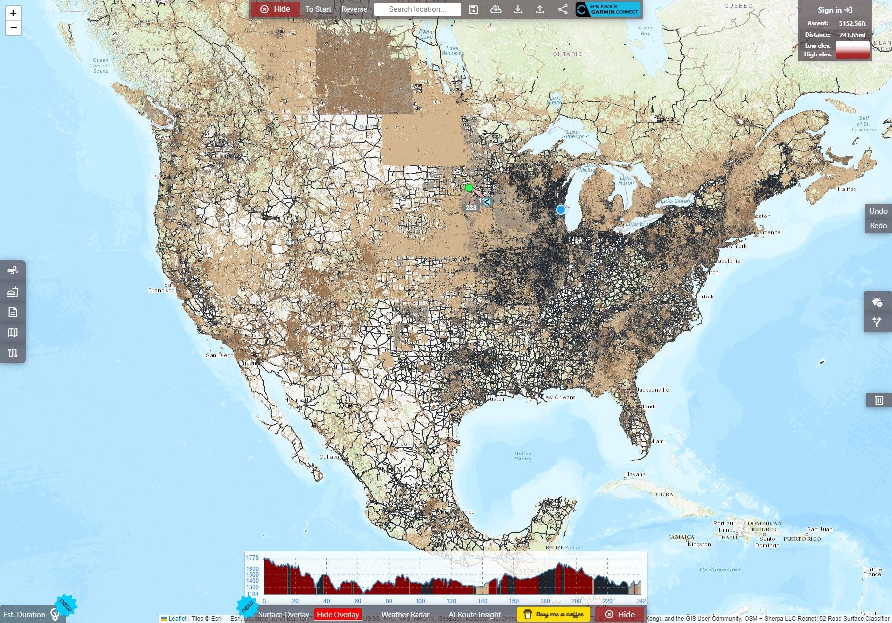
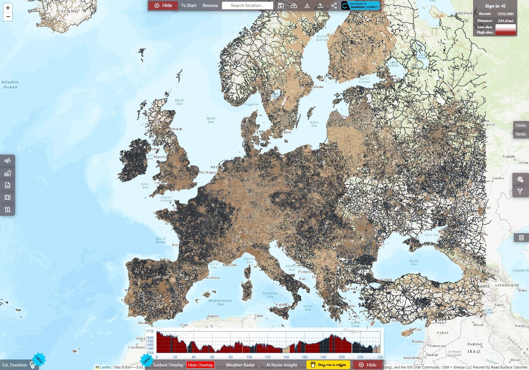
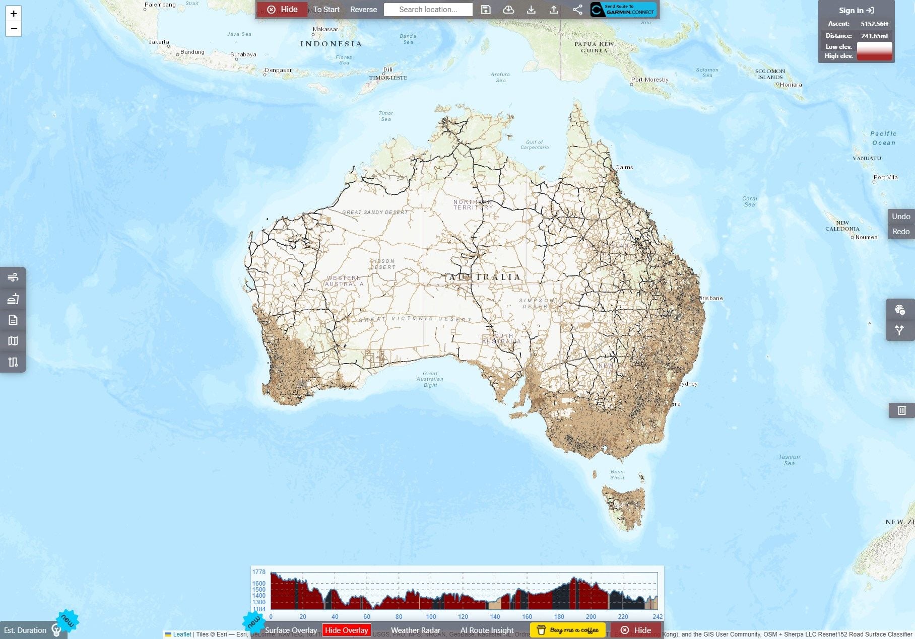
Our latest addition is a stunning overlay showcasing what road is what surface type for all of North America, Europe (plus some area around Europe), and Australia from Open Street Map + AI classified data!
You can access this at the bottom of the interface, by simply pressing the "Show Overlay" button.
Black: Paved
Gray: Gravel
Brown/reddish color: Dirt
Tan: Unpaved (misc category that doesn't fit the above)
This can be overlaid on a variety of different map types, including OSM/Google/Terrain/Mapbox, etc.
Not only did it take months of effort to create a pipeline to properly generate this, but the other mentioned source, using AI classification, has been an ongoing research and development effort, that's even prompted us to purchase a whole new workstation in addition to numerous server upgrades (this project has been, well, heating our apartment basement).
This system works by using satellite images of roads that lack a classification, are not primary, or in a town (I've defaulted those to paved), I then get a 640x640 satellite image and use a deeplabv3_resnet101 classifier to segment out/pull be the best 240x240 image of the road out of the image, and use a resenet152 classifier I trained to determine if it is paved/unpaved, then an additional classifier to determine if the unpaved is gravel/dirt/unpaved. It will only accept the classification if it's above a 95% confidence level. I've managed this so far with the American states of Wisconsin/Illinois/Minnesota/Iowa, and will keep on classifying (I've also recompiled our routing software to match)!
I'm planning on implementing a right-click mechanism to allow users to instantly update to correct surface types if they find an issue. I'm also working on adding this data to our very own map tiles, which are in the works.
I aim to keep updating and working on this; if you have any suggestions, or requests for location (I'd be happy to add your region), just let us know in the comments.
I'm part of the team of three roommates who've been developing a completely free alternative cycling routing service, similar to Strava's route builder/Kommot/RideWithGPS over the past year, https://sherpa-map.com.
Our latest addition is a stunning overlay showcasing what road is what surface type for all of North America, Europe (plus some area around Europe), and Australia from Open Street Map + AI classified data!
You can access this at the bottom of the interface, by simply pressing the "Show Overlay" button.
Black: Paved
Gray: Gravel
Brown/reddish color: Dirt
Tan: Unpaved (misc category that doesn't fit the above)
This can be overlaid on a variety of different map types, including OSM/Google/Terrain/Mapbox, etc.
Not only did it take months of effort to create a pipeline to properly generate this, but the other mentioned source, using AI classification, has been an ongoing research and development effort, that's even prompted us to purchase a whole new workstation in addition to numerous server upgrades (this project has been, well, heating our apartment basement).
This system works by using satellite images of roads that lack a classification, are not primary, or in a town (I've defaulted those to paved), I then get a 640x640 satellite image and use a deeplabv3_resnet101 classifier to segment out/pull be the best 240x240 image of the road out of the image, and use a resenet152 classifier I trained to determine if it is paved/unpaved, then an additional classifier to determine if the unpaved is gravel/dirt/unpaved. It will only accept the classification if it's above a 95% confidence level. I've managed this so far with the American states of Wisconsin/Illinois/Minnesota/Iowa, and will keep on classifying (I've also recompiled our routing software to match)!
I'm planning on implementing a right-click mechanism to allow users to instantly update to correct surface types if they find an issue. I'm also working on adding this data to our very own map tiles, which are in the works.
I aim to keep updating and working on this; if you have any suggestions, or requests for location (I'd be happy to add your region), just let us know in the comments.

Likes For firebird854:
02-20-24, 12:16 PM
#2

Senior Member

Join Date: Oct 2011
Location: Ellensburg,WA
Posts: 3,180
Bikes: Schwinn Broadway, Specialized Secteur Sport(crashed) Spec. Roubaix Sport, Spec. Crux
Mentioned: 7 Post(s)
Tagged: 0 Thread(s)
Quoted: 179 Post(s)
Liked 169 Times
in
84 Posts
Where does oiled fit in your surface type? It's not exactly unpaved and it is not exactly paved, although you might think it is paved. It is a base of chip seal overlayed with more chipseal.
Kudos for going forward with your app. I don't see a present need for it where I ride but others might.
Kudos for going forward with your app. I don't see a present need for it where I ride but others might.
__________________
Sir Mark, Knight of Sufferlandria
Sir Mark, Knight of Sufferlandria
02-20-24, 12:46 PM
#3
Senior Member
Join Date: Oct 2013
Location: Mich
Posts: 7,395
Bikes: RSO E-tire dropper fixie brifter
Mentioned: 0 Post(s)
Tagged: 0 Thread(s)
Quoted: 6 Post(s)
Liked 2,979 Times
in
1,920 Posts
wonder if this data will be able to be automatically rolled into the "updates" that bicycle computer's push? IE: Wahoo
__________________
-Oh Hey!
-Oh Hey!
02-20-24, 12:51 PM
#4
Senior Member
Join Date: Sep 2007
Location: Far beyond the pale horizon.
Posts: 14,278
Mentioned: 31 Post(s)
Tagged: 0 Thread(s)
Quoted: 4260 Post(s)
Liked 1,363 Times
in
945 Posts
One issue is being able to clearly distinguish surface on a small screen.
 02-20-24, 12:56 PM
#5
Senior Member

Join Date: May 2012
Location: Point Reyes Station, California
Posts: 4,528
Bikes: Indeed!
Mentioned: 92 Post(s)
Tagged: 0 Thread(s)
Quoted: 1507 Post(s)
Liked 3,478 Times
in
1,132 Posts
I applaud what you are doing but when I look at the overlay in my immediate neighborhood (Point Reyes Station, California) most of the roads have no surface indicated.
Brent
Brent
__________________
"I have a tendency to meander sometimes." B.G.
"I have a tendency to meander sometimes." B.G.
02-20-24, 01:24 PM
#6
Senior Member
Join Date: Oct 2013
Location: Mich
Posts: 7,395
Bikes: RSO E-tire dropper fixie brifter
Mentioned: 0 Post(s)
Tagged: 0 Thread(s)
Quoted: 6 Post(s)
Liked 2,979 Times
in
1,920 Posts
just knowing it's not a dirt with the chance of gravel topped surface would be better than assuming the continuing paved road that I am on is expected to remain paved. Fine grey scaled hashing lines to distinguish it not being paved but a continuation of that linear road would be nice.
__________________
-Oh Hey!
-Oh Hey!
02-20-24, 01:32 PM
#7
Senior Member
Thread Starter
Where does oiled fit in your surface type? It's not exactly unpaved and it is not exactly paved, although you might think it is paved. It is a base of chip seal overlayed with more chipseal.
Kudos for going forward with your app. I don't see a present need for it where I ride but others might.
Kudos for going forward with your app. I don't see a present need for it where I ride but others might.
Also, thanks for your kind words! And hey, I do have two other fun free cycling related sites too:
https://sherpa-map.com/cycling-route-calculator.html --Physics simulator with weather and nutrition data lets you determine how fast you will be with what setup around what mixed surface course.
https://sherpa-map.com/activity-racer.html --Watch in realtime your activities in the same area race each other.
02-20-24, 01:36 PM
#8
Senior Member
Thread Starter
You can activate it on the fly by using this tool https://i.imgur.com/ycs7pEe.mp4 but that's using an older model, my new model that I use to augment the overlay is far more sophisticated.
Also, I wrap this data back into my routing engine to help inform cyclists when creating a route.
02-20-24, 01:41 PM
#9
I don't know.

Join Date: May 2003
Location: South Meriden, CT
Posts: 2,015
Bikes: '90 B'stone RB-1, '92 B'stone RB-2, '89 SuperGo Access Comp, '03 Access 69er, '23 Trek 520, '14 Ritchey Road Logic, '09 Kestrel Evoke, '08 Windsor Tourist, '17 Surly Wednesday, '89 Centurion Accordo, '15 CruX, '17 Ridley X-Night, '89 Marinoni
Mentioned: 2 Post(s)
Tagged: 0 Thread(s)
Quoted: 317 Post(s)
Liked 853 Times
in
446 Posts
this is neat and easy to use. Thanks.
everything's black in my area :-(
everything's black in my area :-(
02-20-24, 01:52 PM
#10
Senior Member
Thread Starter
I'm also adding more overlays too, I'm working on adding Strava's heatmap, an overlay that shows popular bike race routes, one that should mtb trails specifically, and one that shows all hiking paths.
Likes For firebird854:
02-20-24, 02:27 PM
#11
Sunshine

Join Date: Aug 2014
Location: Des Moines, IA
Posts: 16,614
Bikes: '18 class built steel roadbike, '19 Fairlight Secan, '88 Schwinn Premis , Black Mountain Cycles Monstercross V4, '89 Novara Trionfo
Mentioned: 123 Post(s)
Tagged: 0 Thread(s)
Quoted: 10965 Post(s)
Liked 7,491 Times
in
4,189 Posts
Interesting project. There is a whole lot of white near me that are paved roads with interstate on/off ramps. I wonder how the tech determines what is/isnt paved since some interstate access roads arent determined. A lot of gravel 15mi from me is white too- unsure what type of surface, I guess?
Most everything is spot on and accurate on where some roads go from paved to gravel.
Most everything is spot on and accurate on where some roads go from paved to gravel.
02-20-24, 02:43 PM
#12
Senior Member
Thread Starter
Interesting project. There is a whole lot of white near me that are paved roads with interstate on/off ramps. I wonder how the tech determines what is/isnt paved since some interstate access roads arent determined. A lot of gravel 15mi from me is white too- unsure what type of surface, I guess?
Most everything is spot on and accurate on where some roads go from paved to gravel.
Most everything is spot on and accurate on where some roads go from paved to gravel.
White is simply the road color for the default map under the surface overlay, if a road doesn't get a coloring from the overlay, it means there is no data in OpenStreet map and I haven't gotten to that area with my AI classification yet.
If you meant something else with your mention of white roads, please correct me.
02-21-24, 09:42 AM
#13
Senior Member
Join Date: Jun 2015
Location: North Central Wisconsin
Posts: 4,624
Mentioned: 14 Post(s)
Tagged: 0 Thread(s)
Quoted: 2976 Post(s)
Liked 1,182 Times
in
771 Posts
Functionally it seems to work well. However, I laid out a route (I'm in WI also) but it didn't get all of the surfaces correct which would make it a no go for me at this point. Ride with GPS seems to be getting the surfaces correct more accurately at this point.
I've also found this helpful...
Gravel Road Maps and Biking Routes - Gravelmap
I've also found this helpful...
Gravel Road Maps and Biking Routes - Gravelmap
