


Needing a basic GPS, few bells and whistles
 05-09-24, 10:43 PM
#1
Full Member
Thread Starter
Needing a basic GPS, few bells and whistles
I cycle in some far corners that I cannot use Google maps with my phone. The Garmin website makes me crazy with all the choices. As an example, I need to navigate back roads in the Czech Republic and in the forests and deserts of North America with primitive roads and trails. If I am hunting cross country in the snow, I want to be able to find my truck. I tried a Garmin Trex and could not use it the screen was so small. It seems like I need a simple device but everything is specialized. I have been putting this off for a long time. I hope this forum can help me. Thanks!
 05-09-24, 10:58 PM
#2

Full Member
Join Date: Mar 2024
Location: San Diego
Posts: 483
Bikes: Columbine, Paramount Track Bike, Colnago Super, Santana Tandems (1995 & 2007), Gary Fisher Piranha, Trek Wahoo, Bianchi Track Bike, a couple of Honda mountain bikes
Mentioned: 1 Post(s)
Tagged: 0 Thread(s)
Quoted: 231 Post(s)
Liked 150 Times
in
99 Posts
Have you tried downloading the Google maps in the area you are riding onto your smartphone?
Also, this may be overkill, but the Foreflight flight app has a street map function with worldwide maps and doesn�t need a cell signal if your smartphone has a gps built in. https://www.foreflight.com/products/foreflight-web/
(caveat- I have an iPhone, so I can�t speak to Android compatibility).
Also, this may be overkill, but the Foreflight flight app has a street map function with worldwide maps and doesn�t need a cell signal if your smartphone has a gps built in. https://www.foreflight.com/products/foreflight-web/
(caveat- I have an iPhone, so I can�t speak to Android compatibility).
__________________
Cheers, Mike
Cheers, Mike
Last edited by PromptCritical; 05-09-24 at 11:06 PM.
05-10-24, 04:27 AM
#3
Senior Member
Join Date: Aug 2010
Location: Madison, WI
Posts: 11,334
Bikes: 1961 Ideor, 1966 Perfekt 3 Speed AB Hub, 1994 Bridgestone MB-6, 2006 Airnimal Joey, 2009 Thorn Sherpa, 2013 Thorn Nomad MkII, 2015 VO Pass Hunter, 2017 Lynskey Backroad, 2017 Raleigh Gran Prix, 1980s Bianchi Mixte on a trainer. Others are now gone.
Mentioned: 48 Post(s)
Tagged: 0 Thread(s)
Quoted: 3522 Post(s)
Liked 1,500 Times
in
1,172 Posts
If an Etrex GPS has too small a screen, you might need to look at other phone apps. I think most off the shelf GPS units are not going to meet your needs for bigger screen.
I would like a bigger screen on my Garmin GPS too, but it is adequate for my needs.
Some phone apps allow you to download maps and use the app off-line.
You said "if you are hunting in the snow". Devices that use Lithium Ion batteries have very poor battery life in cold weather. Thus, a phone could be problematic. All kinds of batteries are bad in cold weather, but Lithium (not rechargeable) AA batteries are suggested for cold weather for my DSLR. I have not used such batteries, they are not cheap. But apparently they are better in the cold. My point is that you might have to make do with a small screen GPS if you are using it in sub freezing temps. Even if you got those batteries for cold weather use, I would suggest you still bring a compass.
Likes For Tourist in MSN:
05-10-24, 08:35 AM
#4
I'm good to go!
Join Date: Jul 2017
Location: Mississippi
Posts: 15,265
Bikes: Tarmac Disc Comp Di2 - 2020
Mentioned: 52 Post(s)
Tagged: 0 Thread(s)
Quoted: 6344 Post(s)
Liked 4,945 Times
in
3,405 Posts
Was it really that the screen was too small on the e-Trex? Or did you just not get use to how the device was intended to be used?
The navigation function on most devices is pretty basic. It's all the other features that come with that you have to put out of your mind and ignore. Every GPS out there comes with a crap load of features you won't want and many you won't understand for quite a while. If you find a GPS that doesn't seem to have a lot of features, you will probably be looking at a cheap brand that will be made to low manufacturing standards and won't last but a few years.
Since you want to be able to find where you left your truck, then you probably should stick with a handheld Garmin or other handheld device. A lot of the cycling specific GPS's aren't really made to easily do that with the ease that some handhelds are.
Your phone might could work for you. But the issue with phones is that using the GPS full time can suck the battery power. And then you'll be lost without a phone to use. Also, I haven't ever had a phone that I feel I can adequately see the screen in bright daylight. Phones also require that you be in the cell tower reception range unless you download the entire map of the area you think you'll be in before leaving the area of reception.
05-10-24, 09:05 AM
#5
Senior Member
Join Date: Jul 2007
Location: South shore, L.I., NY
Posts: 7,020
Bikes: Flyxii FR322, Cannondale Topstone, Miyata City Liner, Specialized Chisel, Specialized Epic Evo
Mentioned: 18 Post(s)
Tagged: 0 Thread(s)
Quoted: 3325 Post(s)
Liked 2,171 Times
in
1,231 Posts
GAIA GPS has you download regions and can be installed on a smartphone, so you don’t need cell service. You can route with this app, has a large variety of maps, including satellite view.
You can also download Google maps to the device for a region, I just spent 2 weeks in Sicily, downloaded the entire island and navigated flawlessly in a car using Google and not using cell data. Worked great.
You can also download Google maps to the device for a region, I just spent 2 weeks in Sicily, downloaded the entire island and navigated flawlessly in a car using Google and not using cell data. Worked great.
Likes For Steve B.:
05-10-24, 10:30 AM
#6
Full Member
Thread Starter
That has worked for me here in the U.S. but it won't work in CZ.
Thanks,
Thanks,
05-10-24, 10:36 AM
#7
Full Member
Thread Starter
If an Etrex GPS has too small a screen, you might need to look at other phone apps. I think most off the shelf GPS units are not going to meet your needs for bigger screen.
I would like a bigger screen on my Garmin GPS too, but it is adequate for my needs.
Some phone apps allow you to download maps and use the app off-line.
You said "if you are hunting in the snow". Devices that use Lithium Ion batteries have very poor battery life in cold weather. Thus, a phone could be problematic. All kinds of batteries are bad in cold weather, but Lithium (not rechargeable) AA batteries are suggested for cold weather for my DSLR. I have not used such batteries, they are not cheap. But apparently they are better in the cold. My point is that you might have to make do with a small screen GPS if you are using it in sub freezing temps. Even if you got those batteries for cold weather use, I would suggest you still bring a compass.
I would like a bigger screen on my Garmin GPS too, but it is adequate for my needs.
Some phone apps allow you to download maps and use the app off-line.
You said "if you are hunting in the snow". Devices that use Lithium Ion batteries have very poor battery life in cold weather. Thus, a phone could be problematic. All kinds of batteries are bad in cold weather, but Lithium (not rechargeable) AA batteries are suggested for cold weather for my DSLR. I have not used such batteries, they are not cheap. But apparently they are better in the cold. My point is that you might have to make do with a small screen GPS if you are using it in sub freezing temps. Even if you got those batteries for cold weather use, I would suggest you still bring a compass.
05-10-24, 10:37 AM
#8
Senior Member

Join Date: Sep 2017
Location: Upstate SC
Posts: 1,738
Mentioned: 3 Post(s)
Tagged: 0 Thread(s)
Quoted: 842 Post(s)
Liked 1,697 Times
in
799 Posts
At the register, the clerk asked why I needed the map and compass.
"Because sometimes batteries die, or GPS satellite signals fail." He smiled and put everything in my bag.
05-10-24, 10:39 AM
#9
Full Member
Thread Starter
GAIA GPS has you download regions and can be installed on a smartphone, so you don’t need cell service. You can route with this app, has a large variety of maps, including satellite view.
You can also download Google maps to the device for a region, I just spent 2 weeks in Sicily, downloaded the entire island and navigated flawlessly in a car using Google and not using cell data. Worked great.
You can also download Google maps to the device for a region, I just spent 2 weeks in Sicily, downloaded the entire island and navigated flawlessly in a car using Google and not using cell data. Worked great.
I have heard of Gaia, and I will check that out.
Thanks
Last edited by Gyro_T; 05-10-24 at 10:45 AM. Reason: thought of something
05-10-24, 10:43 AM
#10
Full Member
Thread Starter
When I was hunting, I went to Cabela's / Bass Pro (forget which, they are the same now) to buy a handheld GPS unit. I also bought the topo map for the area I would be in, and a good compass.
At the register, the clerk asked why I needed the map and compass.
"Because sometimes batteries die, or GPS satellite signals fail." He smiled and put everything in my bag.
At the register, the clerk asked why I needed the map and compass.
"Because sometimes batteries die, or GPS satellite signals fail." He smiled and put everything in my bag.
Likes For Gyro_T:
05-10-24, 11:04 AM
#11
Senior Member
Join Date: Jul 2007
Location: South shore, L.I., NY
Posts: 7,020
Bikes: Flyxii FR322, Cannondale Topstone, Miyata City Liner, Specialized Chisel, Specialized Epic Evo
Mentioned: 18 Post(s)
Tagged: 0 Thread(s)
Quoted: 3325 Post(s)
Liked 2,171 Times
in
1,231 Posts
The Garmin Explore 2 is the less expensive of the large screen Garmin cycling computers. Does not provide for the training and performance functions of the more expensive models. Is designed for map and navigation for cycling tourists. Runs about $300 in the US. You can download .gpx files to it.
Likes For Steve B.:
05-10-24, 11:36 PM
#12
Full Member
Thread Starter
The Garmin Explore 2 is the less expensive of the large screen Garmin cycling computers. Does not provide for the training and performance functions of the more expensive models. Is designed for map and navigation for cycling tourists. Runs about $300 in the US. You can download .gpx files to it.
05-11-24, 11:05 AM
#13
Senior Member
Join Date: Aug 2010
Location: Madison, WI
Posts: 11,334
Bikes: 1961 Ideor, 1966 Perfekt 3 Speed AB Hub, 1994 Bridgestone MB-6, 2006 Airnimal Joey, 2009 Thorn Sherpa, 2013 Thorn Nomad MkII, 2015 VO Pass Hunter, 2017 Lynskey Backroad, 2017 Raleigh Gran Prix, 1980s Bianchi Mixte on a trainer. Others are now gone.
Mentioned: 48 Post(s)
Tagged: 0 Thread(s)
Quoted: 3522 Post(s)
Liked 1,500 Times
in
1,172 Posts
When I was hunting, I went to Cabela's / Bass Pro (forget which, they are the same now) to buy a handheld GPS unit. I also bought the topo map for the area I would be in, and a good compass.
At the register, the clerk asked why I needed the map and compass.
"Because sometimes batteries die, or GPS satellite signals fail." He smiled and put everything in my bag.
At the register, the clerk asked why I needed the map and compass.
"Because sometimes batteries die, or GPS satellite signals fail." He smiled and put everything in my bag.
Get on an airplane, sit down, push a button on my watch to change time zones and get a battery warning. Compass never worked on that trip. Later, walking between narrow buildings in an area where the streets were still in the same places that they were in medieval times and once my GPS lost location due to insufficient number of satellites, I essentially have no clue which way is which because it was a cloudy day. Got dreadfully lost until I got to a town square where I could get enough satellites for the GPS to calculate a position.
Also on that trip, one of my alarm clock batteries was too low. When the alarm went off, instead of sound it stopped the clock from functioning because of insufficient power. When you change that many time zones, a functioning alarm clock is pretty important.
Now I bring redundancies.
Likes For Tourist in MSN:
05-11-24, 11:30 AM
#14
Senior Member
Join Date: Aug 2010
Location: Madison, WI
Posts: 11,334
Bikes: 1961 Ideor, 1966 Perfekt 3 Speed AB Hub, 1994 Bridgestone MB-6, 2006 Airnimal Joey, 2009 Thorn Sherpa, 2013 Thorn Nomad MkII, 2015 VO Pass Hunter, 2017 Lynskey Backroad, 2017 Raleigh Gran Prix, 1980s Bianchi Mixte on a trainer. Others are now gone.
Mentioned: 48 Post(s)
Tagged: 0 Thread(s)
Quoted: 3522 Post(s)
Liked 1,500 Times
in
1,172 Posts
You have made it clear that a small screen is not sufficient. I wish my screen was bigger, but it is what it is. If you change your mind, I use a Garmin 62S or Garmin 64 for bicycling, canoeing, kayaking, etc. I can load different maps into it from the internet. It has been over a decade since the last time I bought any maps from Garmin.
This is my source for bike maps.
https://extract.bbbike.org
This is one of my sources for topo maps in USA.
https://www.gmaptool.eu/en/content/u...-topo-routable
Europe.
https://www.openfietsmap.nl/downloads/europe
Instead of the joystick, the models I use have cursor keys.
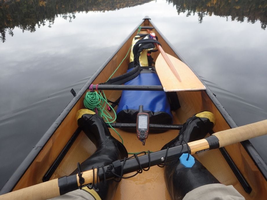
I use a handlebar bracket to hold the GPS on my canoe foot brace. This is in Boundary Waters Canoe Area in Northern Minnesota.
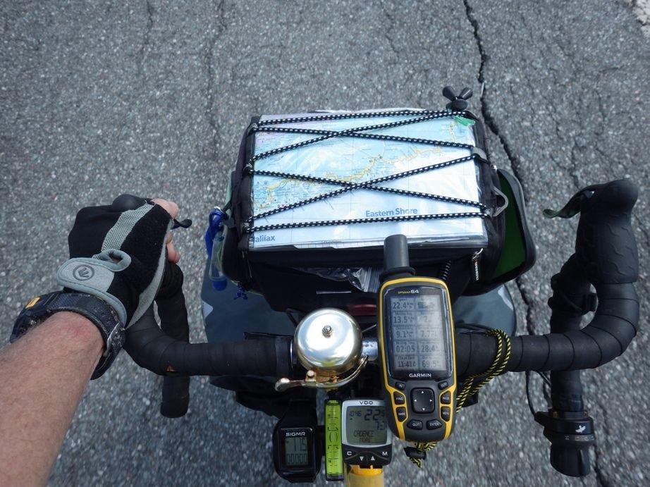
I know bicyclists that use Etrex models for randonneuring. My first photo above was on my bike tour in Nova Scotia.
But, I was doing a lot of this sort of thing before GPS technology was invented, so maybe I am more accepting of limitations of the latest tech.
This is my source for bike maps.
https://extract.bbbike.org
This is one of my sources for topo maps in USA.
https://www.gmaptool.eu/en/content/u...-topo-routable
Europe.
https://www.openfietsmap.nl/downloads/europe
Instead of the joystick, the models I use have cursor keys.
I use a handlebar bracket to hold the GPS on my canoe foot brace. This is in Boundary Waters Canoe Area in Northern Minnesota.
I know bicyclists that use Etrex models for randonneuring. My first photo above was on my bike tour in Nova Scotia.
But, I was doing a lot of this sort of thing before GPS technology was invented, so maybe I am more accepting of limitations of the latest tech.

Likes For njkayaker:
05-11-24, 12:17 PM
#16
I'm good to go!
Join Date: Jul 2017
Location: Mississippi
Posts: 15,265
Bikes: Tarmac Disc Comp Di2 - 2020
Mentioned: 52 Post(s)
Tagged: 0 Thread(s)
Quoted: 6344 Post(s)
Liked 4,945 Times
in
3,405 Posts
I haven't had the need to use maps for other regions than North America in quite a long while. I was wondering what Garmin offered now for map changes on their Edge products. I thought this interesting that some models of the Edge allow for maps to be swapped out at no charge with a Garmin cycling map.
https://www.garmin.com/en-US/p/155338
Maybe not news for y'all, but it is for me. And before you go to the trouble to tell me, I know that you can get free open street maps and such also for many Garmin devices now.
Edge� 540/840/1030 Plus/1040/Explore 2 Series devices do not require purchase for Garmin Cycle Maps and offer free map swaps and updates via Garmin Express™.
Maybe not news for y'all, but it is for me. And before you go to the trouble to tell me, I know that you can get free open street maps and such also for many Garmin devices now.
05-12-24, 02:00 AM
#17
Senior Member
Join Date: Sep 2007
Location: Far beyond the pale horizon.
Posts: 14,369
Mentioned: 32 Post(s)
Tagged: 0 Thread(s)
Quoted: 4317 Post(s)
Liked 1,394 Times
in
973 Posts
I haven't had the need to use maps for other regions than North America in quite a long while. I was wondering what Garmin offered now for map changes on their Edge products. I thought this interesting that some models of the Edge allow for maps to be swapped out at no charge with a Garmin cycling map.
The Garmin Cycle maps are based on Openstreetmap like most of the free maps.
Garmin should have provided these maps for the older units free as well.
Some of the models have enough memory to avoid needing swapping.
Swapping is fussy enough that people might be better of using a free custom map. Usually, people only need a small custom region.
Last edited by njkayaker; 05-12-24 at 02:05 AM.
