


Garmin Activity Profiles and Routes
 05-24-23, 05:50 PM
#1
ignominious poltroon
Thread Starter

Join Date: Jan 2022
Posts: 4,046
Mentioned: 3 Post(s)
Tagged: 0 Thread(s)
Quoted: 2241 Post(s)
Liked 3,443 Times
in
1,802 Posts
Garmin Activity Profiles and Routes
I would like to create an Activity Profile for my Edge 530 specific to commuting. Ideally, if I select this activity, it would automatically follow my pre-planned commuting route (i.e, Course) without having to manually select the Course every time I initiate this activity.
Is this possible? (The on-line user manual doesn't make it obvious, if it is possible.)
Is this possible? (The on-line user manual doesn't make it obvious, if it is possible.)
Last edited by Polaris OBark; 05-24-23 at 06:28 PM. Reason: correct Garmin terminology
 05-24-23, 05:57 PM
#2
Senior Member
Join Date: Sep 2007
Location: Far beyond the pale horizon.
Posts: 14,278
Mentioned: 31 Post(s)
Tagged: 0 Thread(s)
Quoted: 4260 Post(s)
Liked 1,363 Times
in
945 Posts
No, there's no way of automatically loading a course by selecting a profile.
You could set your commuting course to always display (but there won't be any navigation).
You could set your commuting course to always display (but there won't be any navigation).
Last edited by njkayaker; 05-24-23 at 06:02 PM.
Likes For njkayaker:
05-24-23, 06:00 PM
#3
Senior Member
Join Date: Jul 2007
Location: South shore, L.I., NY
Posts: 6,885
Bikes: Flyxii FR322, Cannondale Topstone, Miyata City Liner, Specialized Chisel, Specialized Epic Evo
Mentioned: 18 Post(s)
Tagged: 0 Thread(s)
Quoted: 3242 Post(s)
Liked 2,086 Times
in
1,181 Posts
No. Activity profiles do not start what Garmin calls a "course". Activity profiles are really just a storage location for a configuration for data screens, etc..,., Easy enough to just have the commute in the Nav section and just go and start. Curious though, after I had done my 27 mile very complicated commute with a lit of turns, maybe 3 times, I didnt need nav help after that. Why do you need this ?
Likes For Steve B.:
05-24-23, 06:24 PM
#4
ignominious poltroon
Thread Starter
Join Date: Jan 2022
Posts: 4,046
Mentioned: 3 Post(s)
Tagged: 0 Thread(s)
Quoted: 2241 Post(s)
Liked 3,443 Times
in
1,802 Posts
I just realized I should have used "courses".
I want(ed) to use ProClimb on this "course" with a one button press (if possible). I have about 2000 ft of climbing on my ride home.
Why do you need this ?
05-24-23, 06:25 PM
#5
ignominious poltroon
Thread Starter
Join Date: Jan 2022
Posts: 4,046
Mentioned: 3 Post(s)
Tagged: 0 Thread(s)
Quoted: 2241 Post(s)
Liked 3,443 Times
in
1,802 Posts
Likes For Polaris OBark:
05-24-23, 07:23 PM
#6
Senior Member
Join Date: Jul 2007
Location: South shore, L.I., NY
Posts: 6,885
Bikes: Flyxii FR322, Cannondale Topstone, Miyata City Liner, Specialized Chisel, Specialized Epic Evo
Mentioned: 18 Post(s)
Tagged: 0 Thread(s)
Quoted: 3242 Post(s)
Liked 2,086 Times
in
1,181 Posts
Yes, but know that you still have to go into Navigation and start a course. Nothing will automatically start it.
05-24-23, 07:30 PM
#7
ignominious poltroon
Thread Starter
Join Date: Jan 2022
Posts: 4,046
Mentioned: 3 Post(s)
Tagged: 0 Thread(s)
Quoted: 2241 Post(s)
Liked 3,443 Times
in
1,802 Posts
I was hoping it would provide a short-cut, but you are right.
05-24-23, 07:31 PM
#8
ignominious poltroon
Thread Starter
Join Date: Jan 2022
Posts: 4,046
Mentioned: 3 Post(s)
Tagged: 0 Thread(s)
Quoted: 2241 Post(s)
Liked 3,443 Times
in
1,802 Posts
The newer Garmins have a feature that will activate ProClimb without having to do anything other than have a course file on the Garmin. That would essentially solve the problem.
Maybe that will trickle down to the 530.
Maybe that will trickle down to the 530.
Likes For Polaris OBark:
05-24-23, 08:56 PM
#9
Senior Member
Join Date: Jul 2007
Location: South shore, L.I., NY
Posts: 6,885
Bikes: Flyxii FR322, Cannondale Topstone, Miyata City Liner, Specialized Chisel, Specialized Epic Evo
Mentioned: 18 Post(s)
Tagged: 0 Thread(s)
Quoted: 3242 Post(s)
Liked 2,086 Times
in
1,181 Posts
It somewhat makes sense for the device to ask, when you start the route record process, for the device to ask if you want to follow a saved course. Most might say No, others might want to, press Yes and the device would then take you to the Nav section and let you select from a course list. You get to suggest this major change to Garmin.
Likes For Steve B.:
05-24-23, 09:29 PM
#10

don't try this at home.

Join Date: Jan 2006
Location: N. KY
Posts: 5,940
Mentioned: 10 Post(s)
Tagged: 0 Thread(s)
Quoted: 974 Post(s)
Liked 512 Times
in
352 Posts
Climbpro vs Elevation
I dislike Climbpro: It stops the climb info exactly at the crest of the hill. I also want to know what's coming after that: a downhill, some rollers, or what? I want to know about downhill grades and know what's ahead on rolling courses.
For example,this climbpro hill was stupid a few years ago: a steady 7% grade for a mile, then a slight elevation gain on the uplands for two more miles, with lots of 1% grades. That's not the "crest" for just about any cyclist.
Instead of climbpro, my 1030 can have a separate "Elevation" screen. (and it works on an 830, and probably other models too) When following a route, I have it scaled to show the next 1.5 miles (and the previous 0.5 miles for comparison) with a 200 foot increment vertically. I get a nice chart that scrolls as I ride. I can estimate grades pretty well at this scale, within a couple of percent. A 5-7% grade is obviously different than a 10-12% grade. So I can see where the steep parts are, and if there's any easier sections in the middle.
Even on rolling terrain, this Elevation chart is really useful. What's over the next hill? Can I attack the short climb, or should I just spin up it? Is it all trending uphill or downhill? On bigger climbs: What's after the crest of the big climb ahead? When does the hill start-- I can see 1.5 miles ahead--"here it comes".
~~~~~~
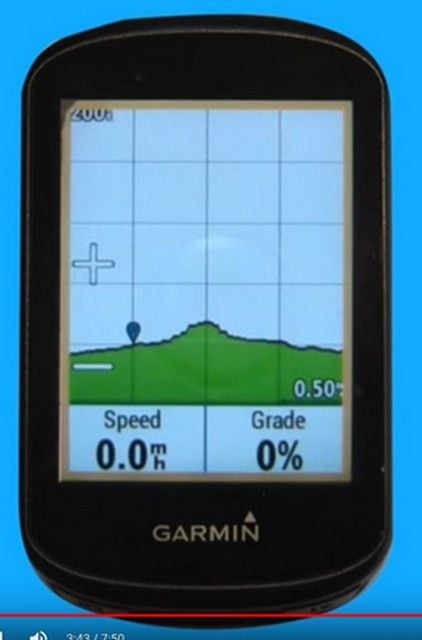
From a Edge 530 howto video, here's an example.
Each square is 200 feet high and 0.5 miles long. (the same scaling I use, but both can be increased and/or decreased.)
The rider's current position is always at the pin icon at the first tickmark intersection. The chart scrolls right to left as they ride.
I can see the crest of this small hill is 0.5 miles ahead, and 60-80 feet high, since each square is 200 feet tall.
the current grade of around 1-2% continues for a quarter mile ahead, then gets steeper, maybe 5-6%.
A shallow downhill that will need some easy pedaling extends at least a mile after the crest.
I dislike Climbpro: It stops the climb info exactly at the crest of the hill. I also want to know what's coming after that: a downhill, some rollers, or what? I want to know about downhill grades and know what's ahead on rolling courses.
For example,this climbpro hill was stupid a few years ago: a steady 7% grade for a mile, then a slight elevation gain on the uplands for two more miles, with lots of 1% grades. That's not the "crest" for just about any cyclist.
Instead of climbpro, my 1030 can have a separate "Elevation" screen. (and it works on an 830, and probably other models too) When following a route, I have it scaled to show the next 1.5 miles (and the previous 0.5 miles for comparison) with a 200 foot increment vertically. I get a nice chart that scrolls as I ride. I can estimate grades pretty well at this scale, within a couple of percent. A 5-7% grade is obviously different than a 10-12% grade. So I can see where the steep parts are, and if there's any easier sections in the middle.
Even on rolling terrain, this Elevation chart is really useful. What's over the next hill? Can I attack the short climb, or should I just spin up it? Is it all trending uphill or downhill? On bigger climbs: What's after the crest of the big climb ahead? When does the hill start-- I can see 1.5 miles ahead--"here it comes".
~~~~~~
From a Edge 530 howto video, here's an example.
Each square is 200 feet high and 0.5 miles long. (the same scaling I use, but both can be increased and/or decreased.)
The rider's current position is always at the pin icon at the first tickmark intersection. The chart scrolls right to left as they ride.
I can see the crest of this small hill is 0.5 miles ahead, and 60-80 feet high, since each square is 200 feet tall.
the current grade of around 1-2% continues for a quarter mile ahead, then gets steeper, maybe 5-6%.
A shallow downhill that will need some easy pedaling extends at least a mile after the crest.
Last edited by rm -rf; 05-24-23 at 09:46 PM.
Likes For rm -rf:
