


Advice for a north to south route in Portugal
 01-07-24, 04:50 PM
#1
Senior Member
Thread Starter

Advice for a north to south route in Portugal
I am planning a north to south ride in Portugal in October of 2024. I'm wondering if you fine folks would perhaps have a GPX file of a route you've done in the past OR provide some advice on routes to take.
I had planned just to cycle the N2 route but I've been told (by a tour operator) that the N2 route is not necessarily the best choice; some sections are ok, some not.
- I'm looking for a route north to south OR it can be south to north
- perhaps 80-100km per day for 7-10 days
- my wife will be joining me but she will be driving, which should open up options for places to stay. She'll be doing her own thing but will meet me at the next stop.
- I'm not specifically looking for anything in particular such as an ocean view, along the coast is fine, in-land route is fine, hills are fine
- the bike I will have has 38mm tires, road bike, steel frame, quite low gearing, cable disc brakes so a dirt road or trail is fine (but not like a single track or ATV trail)
- I'm not sure of the start city, I guess we will likely land in Lisbon and then drive north, where I will start the ride. After the ride we will make our way back to Lisbon I guess.
- we are kinda sorta vegetarian - we do eat fish but no pork, beef or fowl (I do not want to get into a discussion about "well, that's not vegetarian" it is the easiest way to describe our diet)
Any advice is appreciated.
Thank you.
D.
 01-07-24, 05:33 PM
#2
Senior Member
Join Date: Mar 2010
Posts: 1,660
Mentioned: 7 Post(s)
Tagged: 0 Thread(s)
Quoted: 1248 Post(s)
Liked 1,323 Times
in
674 Posts
I had spent a month cycling Portugal in October did a big circle tour starting in Lisbon. So my advice will be generic in nature. Took the train to Evora to start as cycling out of Lisbon is nothing interesting and can be hectic. I stayed away from the coast as it is very busy and unappealing to myself as I love small towns without a large tourist population. My touring approach is I pick a general direction and find accommodation that interest me at an appropriate distance. Then I build a route on RideWithGPS selecting quiet secondary roads and gravel paths. I found the riding, food and accommodation amazing and people very generous. Stay inland close to the Spanish border you will be amazed at the quiet peaceful roads. Extremely low traffic volumes were the norm and the drivers were courteous. Prices were very reasonable as well. If you enjoy wine what a surprise as the local product was fantastic.
Find towns your wife would like to stay in and ride from point to point from there no more structure required. Yes the N2 can be very busy and the motorcycles were terrible, the only place I did not enjoy the riding was on the N2. Just pick a secondary road and enjoy.
Find towns your wife would like to stay in and ride from point to point from there no more structure required. Yes the N2 can be very busy and the motorcycles were terrible, the only place I did not enjoy the riding was on the N2. Just pick a secondary road and enjoy.

Likes For Atlas Shrugged:
01-08-24, 10:11 AM
#3
Senior Member
Thread Starter
I had spent a month cycling Portugal in October did a big circle tour starting in Lisbon. So my advice will be generic in nature. Took the train to Evora to start as cycling out of Lisbon is nothing interesting and can be hectic. I stayed away from the coast as it is very busy and unappealing to myself as I love small towns without a large tourist population. My touring approach is I pick a general direction and find accommodation that interest me at an appropriate distance. Then I build a route on RideWithGPS selecting quiet secondary roads and gravel paths. I found the riding, food and accommodation amazing and people very generous. Stay inland close to the Spanish border you will be amazed at the quiet peaceful roads. Extremely low traffic volumes were the norm and the drivers were courteous. Prices were very reasonable as well. If you enjoy wine what a surprise as the local product was fantastic.
Find towns your wife would like to stay in and ride from point to point from there no more structure required. Yes the N2 can be very busy and the motorcycles were terrible, the only place I did not enjoy the riding was on the N2. Just pick a secondary road and enjoy.
Find towns your wife would like to stay in and ride from point to point from there no more structure required. Yes the N2 can be very busy and the motorcycles were terrible, the only place I did not enjoy the riding was on the N2. Just pick a secondary road and enjoy.
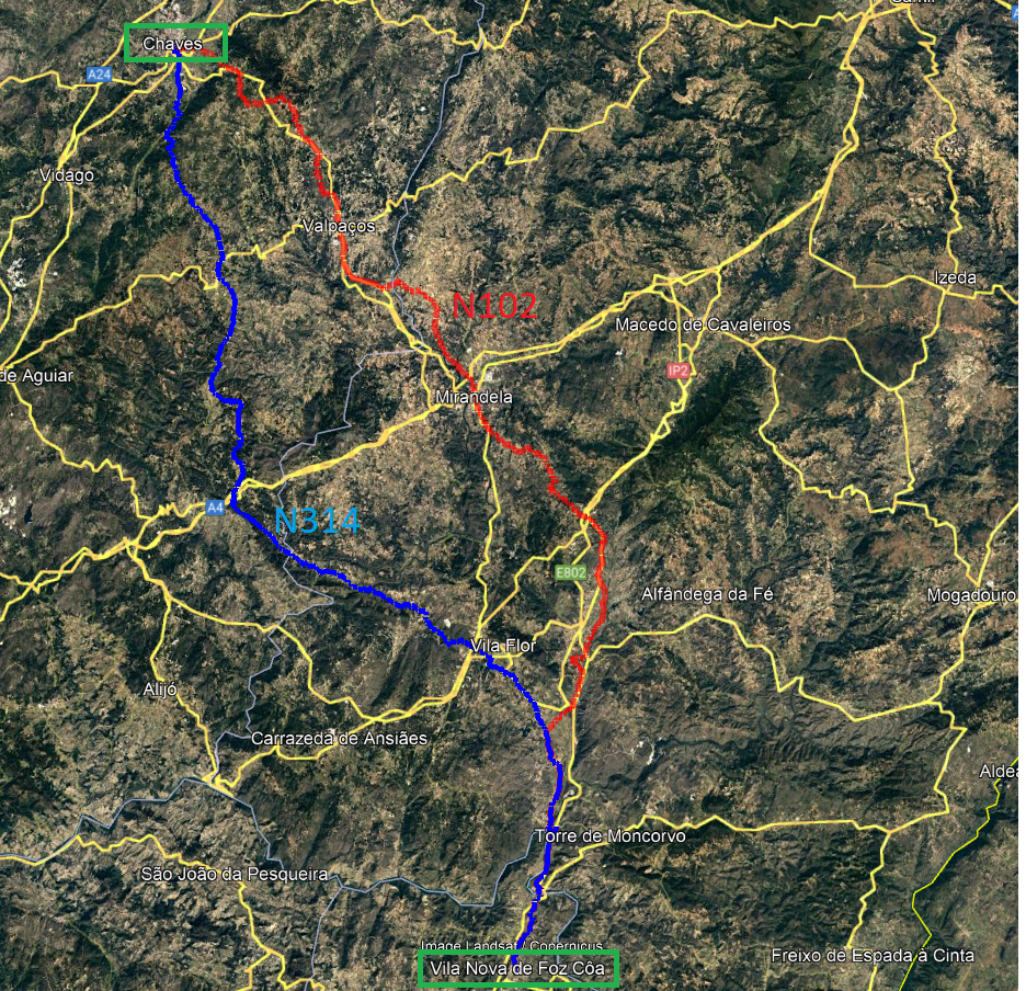
I've found some GPX files that take me north to south along the Spanish border:
Vila Nova de Foz Coa to Castelo Branco
Castelo Branco to Evora
Evora to Loule
The only route I do not have is starting at Chaves then going to Vila Nova de Foz Coa, so I had to make that one myself. I've attached an image of 2 possible routes and I'm wondering, if you're familiar with these routes, which one you would think is best?
The blue route runs along N314
The red route runs along N102
I've indicated the towns via a square green box.
 01-08-24, 10:24 AM
#4
aka Timi
I�ve ridden the whole coast a couple of times.
My advice may seem a bit strange in these modern times, but I would use paper maps. Google maps �bicycle� will easily put you on stony goat paths, �car without highways� are the quickest routes but often main roads.
I�d follow a paper map�s small roads as close to the coast as possible.
It�s easy to catch trains with your bike. Download the CP app and register well before you need to buy tickets.
The larger supermarkets have a good selection of veggie/vegan foods (tofu, TSP etc). Happy Cow app can be helpful for caf�s and restaurants.
01-08-24, 11:01 AM
#5
Senior Member
Thread Starter
I�ve ridden the whole coast a couple of times.
My advice may seem a bit strange in these modern times, but I would use paper maps. Google maps �bicycle� will easily put you on stony goat paths, �car without highways� are the quickest routes but often main roads.
I�d follow a paper map�s small roads as close to the coast as possible.
It�s easy to catch trains with your bike. Download the CP app and register well before you need to buy tickets.
The larger supermarkets have a good selection of veggie/vegan foods (tofu, TSP etc). Happy Cow app can be helpful for caf�s and restaurants.
My advice may seem a bit strange in these modern times, but I would use paper maps. Google maps �bicycle� will easily put you on stony goat paths, �car without highways� are the quickest routes but often main roads.
I�d follow a paper map�s small roads as close to the coast as possible.
It�s easy to catch trains with your bike. Download the CP app and register well before you need to buy tickets.
The larger supermarkets have a good selection of veggie/vegan foods (tofu, TSP etc). Happy Cow app can be helpful for caf�s and restaurants.
I've been told to avoid the coast due to higher traffic and ride the Spain/Portugal border, in fact, I found a 'castle route' near Evora that my wife is VERY interested in.
 01-08-24, 11:50 AM
#6
Member
A friend & I toured in Portugal quite a few years ago and I don't recall all of the specifics of our route. However, I do recall that by far our favorite area was the Douro valley. The Douro largely flows east-west, not north-south. Therefore I would suggest that you don't fixate on strictly a north-south route. Otherwise, you'll find yourself quickly crossing an area like the Douro valley and missing out on most of what for us, was the most enjoyable cycling in Portugal.
We put together our route based on places we wanted to visit, often spontaneously putting together our route each day. We made sure we stopped in Sintra, not that far from Lisbon, and we enjoyed Sintra a lot. Also, on a later trip to northern Spain I crossed the border and biked on the Portuguese side of the Minho valley, which was also nice. I recall that there was a bike path on part of that ride on the Portuguese side, too.
BTW, on a recent bike trip to Sardinia, Google maps directed me onto an outdoor staircase in a very hilly village.
Likes For axolotl:
01-08-24, 08:42 PM
#7
Senior Member
Join Date: Mar 2010
Posts: 1,660
Mentioned: 7 Post(s)
Tagged: 0 Thread(s)
Quoted: 1248 Post(s)
Liked 1,323 Times
in
674 Posts
If you feel more comfortable with paper maps it’s all good, ensure you get a set of detailed high resolution maps such as the Michelin maps for France however I haven’t used a paper map in 20 years. I use google maps for verification of a route built with proper routing software, street view is amazing and transformative, but I would never use google for route building. My route builder of choice is RideWithGPS but I also use Komoot both are excellent and the annual price is negligible in the big scheme of things. Both of the above export the routes directly into your GPS device. Most importantly RideWithGPS has a heat map feature showing the roads most frequented by cyclists in the area further validating the route build. This method has guided me all through Europe, Vietnam, India and most regions of the US.
As previously mentioned I would build the trip around the regions and towns you wish to see. This is a highly personalized endeavor and need to find what works for you and your interests. I avoid tourist zones such as the Algarve like the plague and loved the upper Douro or Tras os Montes.
As previously mentioned I would build the trip around the regions and towns you wish to see. This is a highly personalized endeavor and need to find what works for you and your interests. I avoid tourist zones such as the Algarve like the plague and loved the upper Douro or Tras os Montes.
01-09-24, 05:49 PM
#8
Senior Member
Thread Starter
If you feel more comfortable with paper maps it�s all good, ensure you get a set of detailed high resolution maps such as the Michelin maps for France however I haven�t used a paper map in 20 years. I use google maps for verification of a route built with proper routing software, street view is amazing and transformative, but I would never use google for route building. My route builder of choice is RideWithGPS but I also use Komoot both are excellent and the annual price is negligible in the big scheme of things. Both of the above export the routes directly into your GPS device. Most importantly RideWithGPS has a heat map feature showing the roads most frequented by cyclists in the area further validating the route build. This method has guided me all through Europe, Vietnam, India and most regions of the US.
As previously mentioned I would build the trip around the regions and towns you wish to see. This is a highly personalized endeavor and need to find what works for you and your interests. I avoid tourist zones such as the Algarve like the plague and loved the upper Douro or Tras os Montes.
As previously mentioned I would build the trip around the regions and towns you wish to see. This is a highly personalized endeavor and need to find what works for you and your interests. I avoid tourist zones such as the Algarve like the plague and loved the upper Douro or Tras os Montes.
I�ll also look into the Douro Valley.
01-10-24, 05:47 AM
#9
Senior Member
Join Date: Sep 2013
Location: Spain
Posts: 1,070
Mentioned: 4 Post(s)
Tagged: 0 Thread(s)
Quoted: 277 Post(s)
Liked 497 Times
in
240 Posts
RidewithGPS is fantastic, plan your route at home and download it for off road use. No paper-map in the world can compete with the information one gets with online maps.
01-10-24, 12:49 PM
#10
Senior Member
Join Date: Jan 2010
Posts: 39,269
Mentioned: 211 Post(s)
Tagged: 1 Thread(s)
Quoted: 18430 Post(s)
Liked 15,585 Times
in
7,339 Posts
I agree with the suggestion that you figure out what you might want to see. I one planned a 7 week tour on Andalucia using The Rough Guide for the territory then mapping out a route using the Michelin map. (We didn�t need no stinking GPS.  )
)
There is a Rough Guide for Portugal:
https://www.amazon.com/Rough-Guide-P...4912129&sr=8-1
One thing I really appreciated was that the book didn�t sugar coat everything. If a place was �meh� or touristy or sucked, it said so.
)There is a Rough Guide for Portugal:
https://www.amazon.com/Rough-Guide-P...4912129&sr=8-1
One thing I really appreciated was that the book didn�t sugar coat everything. If a place was �meh� or touristy or sucked, it said so.
01-11-24, 05:18 PM
#11
Member
That's an absurd blanket statement you made concerning paper maps. My absolute favorite paper maps are the French I.G.N. 1:100,000 scale. I count about 80 different pieces of information these maps display. And unlike online maps, I.G.N. maps have never put me onto a staircase, or a route which simply dead-ended, or onto a dirt road which the map had claimed was paved. All of these things have happened to me with online maps. Also, it's much more difficult to get the big picture from an online maps, which is why I especially like to use them for planning purposes. I do use online maps, however, which can be great for navigation.
01-11-24, 06:00 PM
#12
Senior Member
Thread Starter
That's an absurd blanket statement you made concerning paper maps. My absolute favorite paper maps are the French I.G.N. 1:100,000 scale. I count about 80 different pieces of information these maps display. And unlike online maps, I.G.N. maps have never put me onto a staircase, or a route which simply dead-ended, or onto a dirt road which the map had claimed was paved. All of these things have happened to me with online maps. Also, it's much more difficult to get the big picture from an online maps, which is why I especially like to use them for planning purposes. I do use online maps, however, which can be great for navigation.
I use paper maps for planning and use digital for navigation but with a cautious eye.
01-11-24, 11:07 PM
#13
Senior Member
Join Date: Mar 2010
Posts: 1,660
Mentioned: 7 Post(s)
Tagged: 0 Thread(s)
Quoted: 1248 Post(s)
Liked 1,323 Times
in
674 Posts
That's an absurd blanket statement you made concerning paper maps. My absolute favorite paper maps are the French I.G.N. 1:100,000 scale. I count about 80 different pieces of information these maps display. And unlike online maps, I.G.N. maps have never put me onto a staircase, or a route which simply dead-ended, or onto a dirt road which the map had claimed was paved. All of these things have happened to me with online maps. Also, it's much more difficult to get the big picture from an online maps, which is why I especially like to use them for planning purposes. I do use online maps, however, which can be great for navigation.
With RideWithGPS you can route your ride, utilize street view and actually view the road you will be riding on, satellite view the route to determine condition of gravel paths, show the roads which cyclists frequent by the heat map overlay, find accommodation, food establishments, water sources, camp sites, shelters, detailed elevation profiles including grade, export detailed turn by turn instructions and elevation data onto navigation device and share detailed routing with friends and family. Plus can reroute on demand mid ride with minimal downtime. Spent 8 weeks riding across southern India without major routing issues and this could only be done with digital online maps. Spent a month in southern Vietnam specifically 2 weeks in the Mekong Delta this would be a crap-fest following paper maps incapable of showing trail and canal paths frequented by locals. Amsterdam to Vienna, Gibraltar to Girona, Trans Pyrenees, Paris to San Sebastian, Lisbon to Toulouse, Luang Prabang to Hanoi, I could go on, all done digitally with routes created on the fly, daily. Not to mention the hassle of buying and hauling up to twenty individual maps around avoided.
Best of all we can do as we please and if you prefer paper maps all the better just understand you are missing a amazing opportunity to improve your touring experience by understanding and going digital.
Last edited by Atlas Shrugged; 01-11-24 at 11:49 PM.
Likes For Atlas Shrugged:
01-11-24, 11:25 PM
#14
Senior Member
Join Date: Mar 2010
Posts: 1,660
Mentioned: 7 Post(s)
Tagged: 0 Thread(s)
Quoted: 1248 Post(s)
Liked 1,323 Times
in
674 Posts
I feel you’ve hit the nail on the head axolotl, I’m actually a cartographer and there are pros and cons for both. What I see people do is trust the online maps/GPS exclusively and that ain’t a good idea, you still need situational awareness.
I use paper maps for planning and use digital for navigation but with a cautious eye.
I use paper maps for planning and use digital for navigation but with a cautious eye.
Pilots, mariners and overlanders have fully adopted digital mapping why would cyclists be different.
Last edited by Atlas Shrugged; 01-11-24 at 11:43 PM.
01-12-24, 04:08 AM
#15
Senior Member
Join Date: Sep 2013
Location: Spain
Posts: 1,070
Mentioned: 4 Post(s)
Tagged: 0 Thread(s)
Quoted: 277 Post(s)
Liked 497 Times
in
240 Posts
That's an absurd blanket statement you made concerning paper maps. My absolute favorite paper maps are the French I.G.N. 1:100,000 scale. I count about 80 different pieces of information these maps display. And unlike online maps, I.G.N. maps have never put me onto a staircase, or a route which simply dead-ended, or onto a dirt road which the map had claimed was paved. All of these things have happened to me with online maps. Also, it's much more difficult to get the big picture from an online maps, which is why I especially like to use them for planning purposes. I do use online maps, however, which can be great for navigation.
01-12-24, 04:19 AM
#16
Senior Member
Join Date: Sep 2013
Location: Spain
Posts: 1,070
Mentioned: 4 Post(s)
Tagged: 0 Thread(s)
Quoted: 277 Post(s)
Liked 497 Times
in
240 Posts
This is bordering on ridiculous and typical of Bike Forums most threads quickly devolve into a debate about the superiority of old outdated tech. The issues you experienced with routing software is a result of poor understanding of how it works or poor software such as google maps.
With RideWithGPS you can route your ride, utilize street view and actually view the road you will be riding on, satellite view the route to determine condition of gravel paths, show the roads which cyclists frequent by the heat map overlay, find accommodation, food establishments, water sources, camp sites, shelters, detailed elevation profiles including grade, export detailed turn by turn instructions and elevation data onto navigation device and share detailed routing with friends and family. Plus can reroute on demand mid ride with minimal downtime. Spent 8 weeks riding across southern India without major routing issues and this could only be done with digital online maps. Spent a month in southern Vietnam specifically 2 weeks in the Mekong Delta this would be a crap-fest following paper maps incapable of showing trail and canal paths frequented by locals. Amsterdam to Vienna, Gibraltar to Girona, Trans Pyrenees, Paris to San Sebastian, Lisbon to Toulouse, Luang Prabang to Hanoi, I could go on, all done digitally with routes created on the fly, daily. Not to mention the hassle of buying and hauling up to twenty individual maps around avoided.
Best of all we can do as we please and if you prefer paper maps all the better just understand you are missing a amazing opportunity to improve your touring experience by understanding and going digital.
This is greatly explained. Only I don't like the heat map function, means you cycle on some others people route, what maybe are not elaborated enough. I tried the function at places I know and could see that people do not try to go wild remote.
01-12-24, 07:22 AM
#17
Senior Member
Thread Starter
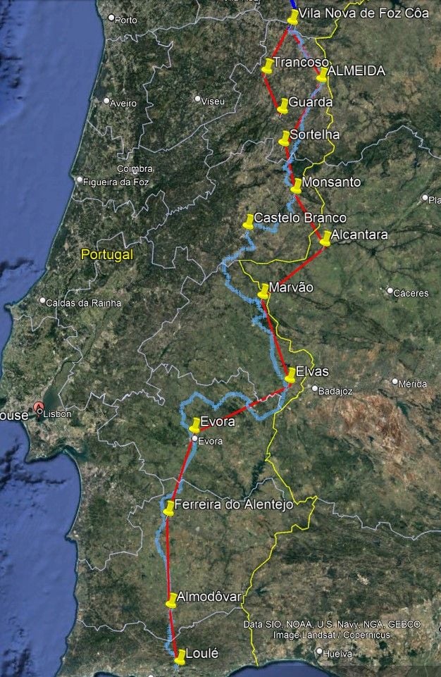
This is the route I've come up with - starting at Guarda and then going clockwise to Trancoso, Vila Nova, etc. The red lines only indicate the intended direction. 12 legs in total, I dip into Spain and I plan on 2 rest days (likely Sortelha and Elvas). Now it is just a matter of determining the best route and I think I will try RideWithGPS as was mentioned here. I've used it in the past, but only to download someone else's GPX file to load into my GPS unit, I've never used it to plan a route/create a GPX. I've had access to other software for that, as part of my work, but now that I am retired, I no longer have that access.
Thoughts from those that have ridden the area?
Thoughts from those that have ridden the area?
01-12-24, 12:35 PM
#18
aka Timi
Paper maps give me a freedom that I didn�t realise I was missing until I went back to them.
But hey, it�s a new digital world and the latest toy is always the best� Am I missing something because I still listen to vinyl records, play an old Les Paul through a tube amp, and write letters to friends with a fountain pen on paper? 😆
Last edited by imi; 01-12-24 at 01:23 PM.
01-12-24, 03:08 PM
#19
Senior Member
Thread Starter
Ok folks, Jesus still loves us all, we will be all alike in less than 100 years, so let's please revert back to more important things - me.
01-12-24, 04:38 PM
#20
Senior Member
Join Date: Mar 2010
Posts: 1,660
Mentioned: 7 Post(s)
Tagged: 0 Thread(s)
Quoted: 1248 Post(s)
Liked 1,323 Times
in
674 Posts
You are assuming that we do not understand or are proficient in digital map technology and planning. Speaking for myself� you are wrong! I�ve been solely digital for a fair number of years, but have reverted to paper maps as they lead me on better routes on the fly, rather than zooming in on everything at home and strictly adhering to my planned route.
Paper maps give me a freedom that I didn�t realise I was missing until I went back to them.
But hey, it�s a new digital world and the latest toy is always the best� Am I missing something because I still listen to vinyl records, play an old Les Paul through a tube amp, and write letters to friends with a fountain pen on paper? 😆
01-15-24, 07:41 PM
#21
Senior Member
Join Date: Jun 2022
Location: The Ring of Fire
Posts: 934
Mentioned: 0 Post(s)
Tagged: 0 Thread(s)
Quoted: 463 Post(s)
Liked 567 Times
in
356 Posts
This is the route I've come up with - starting at Guarda and then going clockwise to Trancoso, Vila Nova, etc. The red lines only indicate the intended direction. 12 legs in total, I dip into Spain and I plan on 2 rest days (likely Sortelha and Elvas). Now it is just a matter of determining the best route and I think I will try RideWithGPS as was mentioned here. I've used it in the past, but only to download someone else's GPX file to load into my GPS unit, I've never used it to plan a route/create a GPX. I've had access to other software for that, as part of my work, but now that I am retired, I no longer have that access.
Thoughts from those that have ridden the area?
Thoughts from those that have ridden the area?
Likes For Ron Damon:
01-16-24, 05:55 AM
#22
Senior Member
Thread Starter
01-16-24, 03:24 PM
#23
Newbie
Join Date: Jan 2024
Posts: 4
Mentioned: 0 Post(s)
Tagged: 0 Thread(s)
Quoted: 2 Post(s)
Likes: 0
Liked 0 Times
in
0 Posts
So, basically, I JUST signed up. Because I was DDG'ed to Digger's question in this thread.
Only after signup now, I realized how Digger's thread digressed.... Not good. I guess we all agree on that.
If an OP asks a question (route, wife, horsebet, doesn't matter), I'd like to keep with the question. If I know sth to answer, I may write it. If I have the same question, I first sign up.

(OMG, I love the smilies here! I had the same gorgeous selection on one of my early sites. I missed them. - Now people call them emojies. So what?)
NOTHING MATTERS, guys and gals.

"we will be all alike in less than 100 years, so let's please revert back to more important things - Digger".

Humor aside (mine): I too am looking for a "good" road trip from north to south Portugal. (Doh! You wouldn't have guessed
) Hence how/ why I found this forum.ONLY two differences: I won't be going on a pedal bike, but bike with emotor.
2nd difference, you are missing?
I don't have a wife in a car to join me.
 Maybe we find us here? Who knows.
 Okay, SO: Most of you seem to agree, I should be going "near the Spanish border". Boy, I like the ambiguousness of that advice!
 Spain is safer, okay, I got it. Just joking - as always.
I finish my post when I got through all the smilies.

Nah, NOW!
PS: I still have to read the "policies", if e-bikers are allowed here at all. The paper-map users know: Bikemeansmanythings, and I wouldn't want to attract harassment for not pedaling...

(That was the final smilie, yeah baby!)
PPS: Anyone who shares my endless humor wanting to join me on the trip?
My PLAN is 2 days, ie with one recharging overnight stop. However, I am blatantly open-minded and flexible: If the trip shall take a week, it can take a week.
Portugal has a LOT for sightseeing, years ago I traveled "all" of it, by truck, with my tiny house on it. Yeah man!
PPPS: The return trip needs planning too: A month or so later, I will be needing to go from south to north. Cheers.
01-19-24, 01:04 AM
#24
Full Member
First of all, get thee over to CGOAB and look at journals for Portugal. Alternatively, check out the map functionality here - a great way to do research. (Just stay away from the forum).
Personally, other people's opinions of where I should go and how to go there are only useful if we're like minded and similarly experienced. Someone's experience of the Portuguese coast in August will be very different to yours in October. Similarly, direction of travel can have a big impact, especially on a coastal route.
My personal preference is to pick places I want to go then try to figure out the best way of doing that.
I'd be wary of picking up random gpx files from the net with no context. Night time riding is popular in summer to avoid the daytime heat. Riding someone's night time route in the daytime might not be a lot of fun.
"Doing the border" means mountains. And lots of them. They can be quite steep in parts and roads can be narrow. Portuguese drivers tend to pass closer than their Spanish counterparts in my experience.
If you're not aware, there is a Camino route (to Santiago de Compostela in Spain), in fact two, (with many variations) that could help with the northern half. Certainly that i an airport that is well used to shipping and receiving bikes.
October 23 had temperatures well into the 30s C in this part of the world. It also had some pretty ferocious storms and severe flooding. My suggestion would be to have flexibility built into your plans.
I use a variety of digital map applications. Hands down for me CycleTravel is the best for picking out quiet, scenic routes with useful applications for multi-day tours. Highly recommend it.
Best of luck on your adventures. This is a great part of the world to tour in.
01-19-24, 06:45 AM
#25
Newbie
Join Date: Jan 2024
Posts: 4
Mentioned: 0 Post(s)
Tagged: 0 Thread(s)
Quoted: 2 Post(s)
Likes: 0
Liked 0 Times
in
0 Posts
Also, I need to correct myself: Likely no more doing a "two-day" trip south, but a trip of at least a week. Reason: I found articles like this - not allowed, okay -
and this - not allowed, okay -
and more articles,
and am enticed to go the (entire?) N2! Possibly even in both directions.


BUT: I want to also first study your tip "... is the best for picking out quiet, scenic routes with useful applications for multi-day tours"

LOL
