


If I had to pick Skyline or Blue Ridge ...
 02-14-19, 01:34 PM
#1
Senior Member
Thread Starter

If I had to pick Skyline or Blue Ridge ...
How better to spend a cold winter day than dreaming of a beautiful place to ride. My wife and I are at the beginning stages of planning a trip out east in the fall of this year. Cycling of course is part of the agenda. I'm hoping not to have to choose between Skyline Drive and Blue Ridge Parkway, but will be limited at most to one day riding along each. I'm asking those of you who've ridden either or both, if you had to pick a one day's ride, what sections or routes would you pick? Ride length of 30 to 50 miles, with 3,000 to 4,000 ft (max) of climbing is preferred. I know nothing of the areas other than what I'm Googling, and I figure you all to be as good or better source of information. If the consensus is to skip the hills and do the ice cream or coffee ride, I'm good with that too.
 02-14-19, 03:32 PM
#2
Senior Member
Join Date: Dec 2010
Location: northern Deep South
Posts: 9,156
Bikes: Fuji Touring, Novara Randonee
Liked 2,160 Times
in
1,328 Posts
Just one day?? That'd be a crying shame, but I'd probably take the BRP out of Asheville "north" to Little Switzerland. That'd be pushing the climbing spec, as well as the miles, but the views... If your wife is driving the car, meet her up at Craggy Gardens for lunch after you've climbed out of Asheville (great view back across the city) and up past the reservoir (quiet valley). Take a few minutes to look over the valley from Marshall to Mars Hill and on over to the mountains on the Tennessee line, then cruise to the foot of Mt Mitchell. It's a steep climb that would be too far to climb, so go down and around to look back at the Black Mountains from the east, while getting occasional views of the Catawba Valley to the east. Coast down to NC 80 and you get one more climb up to Crabtree Falls; fill up your water bottles and coast down to Little Switzerland. You'll have earned your ice cream cone and the steak dinner after that! Then you can sit out on the patio and watch the hawks and crows soaring over the ridge as the sun goes down.
02-14-19, 04:54 PM
#3
Senior Member
Thread Starter
[MENTION=212158]pdlamb[/MENTION] Thank you - awesome information from the perspective of someone who from the sounds of it has ridden it once or twice.
As for my wife ... funny you should assume that she'll be driving. Ever since she got her e-assist road bike, she's loving cycling and the hills.. Thankfully she waits for me at the top.
Any thoughts about Skyline, or am I missing something else better nearby?
As for my wife ... funny you should assume that she'll be driving. Ever since she got her e-assist road bike, she's loving cycling and the hills.. Thankfully she waits for me at the top.
Any thoughts about Skyline, or am I missing something else better nearby?
02-14-19, 04:58 PM
#4
Senior Member
I concur the BRP north out of Asheville toward and up Mt. Mitchell is good riding. You can make nice loop using BRP out of Blowing Rock up over the viaduct at Grandfather Mountain and back down on Hwy 221; I have done this starting at the top going down Hwy 221 and back up the BRP near Blowing Rock. The best month to do this would be September; the BRP can get nuts with traffic during October leaf peeping season.
02-14-19, 05:31 PM
#5
old and in the way
Join Date: Mar 2008
Location: Palisade, CO
Posts: 156
Bikes: Niner RLT, Niner rigid MTB, Salsa Beargrease, Rocky Mountain Element
Likes: 0
Liked 0 Times
in
0 Posts
Definitely plan around October and other major holidays. The BRP can get rather busy at times and the shoulders are not very wide. Unfortunately many drivers are busy looking at the scenery and not the road, so use caution and take measures to be visible. Skyline Drive is gorgeous as well even though the mountains are just a bit smaller in VA. Its been many years since I have been on Skyline, but weekdays were always better.
02-14-19, 06:50 PM
#6
Senior Member
Join Date: Jul 2007
Location: South shore, L.I., NY
Posts: 7,325
Bikes: Flyxii FR322, Cannondale Topstone, Miyata City Liner, Specialized Chisel, Specialized Epic Evo
Liked 2,403 Times
in
1,358 Posts
My thought, having ridden and driven both highways, is if the weather is crap and you don't/can't ride, might be more to do on the Skyline, especially hiking opportunities on the AT and other trails.
Some sections of the BRP are more remote than others, the advice above is good, but in reality, it's all good and I don't think choosing one area over the other is going to leave you disappointed.
Some sections of the BRP are more remote than others, the advice above is good, but in reality, it's all good and I don't think choosing one area over the other is going to leave you disappointed.
02-14-19, 08:01 PM
#7
Member
Quite frankly you cant go wrong with either. The BRP in NC offers awesome views of peak after peak while the SNP will provide views of valleys and peaks in the distance. One thing about the SNP, there is a nice lodge/wayside every 25-30 miles for a nice meal/break or even a good start/stop point. BRP is free, SNP is not. IF you dont like hills, pick another road.
02-15-19, 07:05 AM
#8
Senior Member
Join Date: Jul 2012
Location: Creede CO in summer & Okeechobee, FL or TX Gulf Coast in winter
Posts: 742
Bikes: Zenetto Stealth road bike & Sundeal M7 MTN bike
Likes: 0
Liked 4 Times
in
4 Posts
Agree - one day not enough. Thinking about most scenic ride I know of - this is it
Silver Thread Scenic Hwy
Silver Thread Scenic Hwy
02-15-19, 08:29 AM
#9
Senior Member

I agree with BRP North out of Asheville. Be prepared for a climb up to Craggy Gardens area. Alternatively, same area, South on BRP has some spectacular views, especially from Mt. Pisgah to Black Balsam/Graveyard Fields area. Pisgah Inn is there, as well as Mt. Pisgah picnic/CG. From Blowing Rock, NC to Waynesville there are no "bad" areas. Spectacular views, waterfalls, short hikes...all along the way.
Been years since I've been on Skyline Dr but IIRC, there were not the numbers of views nor scale of vistas with interesting geological features.
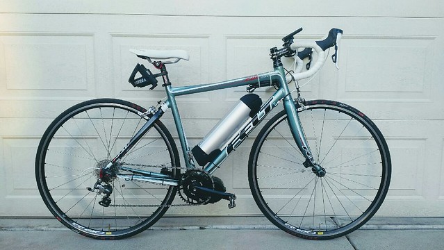
edit to add: What pray tell, is that monsterous thing on the downtube of that bike, a gas tank? Rocket engine? Moonshine still?
Been years since I've been on Skyline Dr but IIRC, there were not the numbers of views nor scale of vistas with interesting geological features.
edit to add: What pray tell, is that monsterous thing on the downtube of that bike, a gas tank? Rocket engine? Moonshine still?
02-15-19, 09:50 AM
#10

don't try this at home.

I don't like the BRP climbs out of Asheville. There's a fair amount of traffic, and it's hard for cars to pass cyclists with all the curves. Weekdays probably aren't too bad, though.
I drive up to the higher elevations and ride from there. It's a little complicated to make a route that has water or food stops available, there's not too many places on the Parkway. I like out-and-back routes, it's never boring to retrace my outbound route, and I see different stuff on the return, climbing the outbound's downhills, and with the sun moved across the sky.
Just one day
Only one day to ride? For me, this route is the best one I've found on the Parkway. It's more climbing than you specified, but worth it. The climbs aren't steep, but there's no flat ground at all, so pacing and reasonable gearing is critical. The 50-55 mile version is probably comparable to 70-80 miles on flat to rolling areas.
I posted it in this thread post: Richland Balsam to the Pisgah Inn route. Check out the photo album in the link. Carryout lunch at the Pisgah Inn, sit on the back deck and check out the views.
Starting at Richland Balsam, it's 46 miles, 5200 feet. (I don't like to start with a downhill, I'd rather extend the route a little and warm up with a climb.)
If you've got the right gears to set a moderate pace on 5-7% grades, you'll be fine on these big climbs. And I like this route that has somewhat shorter climbs with descents in between.
Last edited by rm -rf; 02-15-19 at 09:57 AM.
02-15-19, 10:46 AM
#11
Senior Member
Join Date: Dec 2010
Location: northern Deep South
Posts: 9,156
Bikes: Fuji Touring, Novara Randonee
Liked 2,160 Times
in
1,328 Posts
Pisgah Inn is a great way to take a break or end the day. If you get lucky (in the restaurant or on the back deck), you can watch the hawks soaring down the ridge. If they catch a thermal, it's like watching a 757 take off!
Shenandoah is nice, and has some good climbs, but I don't think it's as exciting as the Blue Ridge Parkway, especially the mountains in N.C. Shenandoah is a bit easier to find (junk) food and water. I used to have a list of water sources on the BRP, but can't find it right now. "Bicycling the Blue Ridge Parkway" is a good resource book if you're going to ride a few days there.
Shenandoah is nice, and has some good climbs, but I don't think it's as exciting as the Blue Ridge Parkway, especially the mountains in N.C. Shenandoah is a bit easier to find (junk) food and water. I used to have a list of water sources on the BRP, but can't find it right now. "Bicycling the Blue Ridge Parkway" is a good resource book if you're going to ride a few days there.
02-15-19, 10:57 AM
#12
Senior Member

Join Date: Jan 2003
Location: Tichborne, Ontario, Canada
Posts: 324
Bikes: Trek 5200, Giant Rainier, Devinci Destination,Motobecane CF, Bike Friday family tandem, Bike Friday NWT
Likes: 0
Liked 2 Times
in
2 Posts
Which e assist motor is installed on the wife's ebike
[MENTION=212158]pdlamb[/MENTION] Thank you - awesome information from the perspective of someone who from the sounds of it has ridden it once or twice.
As for my wife ... funny you should assume that she'll be driving. Ever since she got her e-assist road bike, she's loving cycling and the hills.. Thankfully she waits for me at the top.
Any thoughts about Skyline, or am I missing something else better nearby?
As for my wife ... funny you should assume that she'll be driving. Ever since she got her e-assist road bike, she's loving cycling and the hills.. Thankfully she waits for me at the top.
Any thoughts about Skyline, or am I missing something else better nearby?
Thanks
02-15-19, 11:06 AM
#13
Senior Member
Thread Starter
[MENTION=4635]hockey[/MENTION] It's a Bafang BBS-02, 350W, with brake and gear sensors, and a 52V battery. We can easily ride 50 miles with a mix of large and rolling hills with battery to spare. As I said, it's revolutionized cycling for her. I'll hear her chatting while riding up a hill or asking me "did you see that?" when I'm simply trying to focus on the effort climbing.
02-15-19, 11:14 AM
#14
Senior Member
Thread Starter
Thank you all for the posts. The take away for me is to enjoy the views of Skyline Drive as we drive thru or past, and take the extra day to ride the BRP. The route options are noted as is the warning about "leaf peepers" among which we will be - planning to be in the area mid October. Sadly, the two days is as much as our schedule will allow (this time).
02-15-19, 11:24 AM
#15
Senior Member
Join Date: Jan 2003
Location: Tichborne, Ontario, Canada
Posts: 324
Bikes: Trek 5200, Giant Rainier, Devinci Destination,Motobecane CF, Bike Friday family tandem, Bike Friday NWT
Likes: 0
Liked 2 Times
in
2 Posts
Thanks for the info. Sounds like a good solution to keep the two of us riding.
02-15-19, 12:32 PM
#16
Full Member
Join Date: Oct 2017
Location: South Carolina
Posts: 218
Bikes: Felt ZR3, Specialized Sectur
Likes: 0
Liked 52 Times
in
37 Posts
How better to spend a cold winter day than dreaming of a beautiful place to ride. My wife and I are at the beginning stages of planning a trip out east in the fall of this year. Cycling of course is part of the agenda. I'm hoping not to have to choose between Skyline Drive and Blue Ridge Parkway, but will be limited at most to one day riding along each. I'm asking those of you who've ridden either or both, if you had to pick a one day's ride, what sections or routes would you pick? Ride length of 30 to 50 miles, with 3,000 to 4,000 ft (max) of climbing is preferred. I know nothing of the areas other than what I'm Googling, and I figure you all to be as good or better source of information. If the consensus is to skip the hills and do the ice cream or coffee ride, I'm good with that too.
Just my 2 cents here. I have ridden the BRP a bit and driven both the BRP and Skyline.
BRP for me, no doubt. Fall is definitely busier but it is not THAT busy. Not to the point of bumper to bumper. Avoid the weekends and it is a few cars passing by but that also depends on the part you ride. Around Asheville is the busiest due to the town and the Biltmore. Lots of visitors that time of the year. We drove the section from Asheville to Mt Mitchell on Columbus day a few years ago and the traffic was not a problem at all. Weekday, so the traffic is much lighter. I would concur that the views are spectacular.
My money is on the BRP and summit Mt Mitchell. If you don't do Mitchell you are missing one hell of a climb if that is your thing. Not to mention the views from the top are amazing in all directions. Two of the 3 highest peaks in the east are there. Mt Mitchell of course being the highest peak in the east.
If you want a sidebar, go to Marion, NC (about 30 miles east of Asheville on I-40) and take route 80 up to the BRP. It is called the Devils Whip. Rt 80 from Marion to the BRP has over 180 turns in the road and is about 11 miles in length. The real money does not start until you pass a church on the left at about 7 miles. After that, you enter hell. Once at the top of 80, there is an onramp to the BRP. Mitchell is 16 miles headed south on the BRP. Total distance from Marion to Mitchell is like 25 miles with about 6,000 feet of climbing. I've done it several times and the ride up 80 and then the last 16 on the BRP to Mitchell are worth the suffering. Once on top of Mitchell, you can SAG it back to Asheville but I have to tell you, that descent off of Mitchell is quite a thrill on a bike.
The climbs around Asheville on the BRP can be quite long. Some go on for over 5 miles but they don't average more than 6%. Getting up ON the BRP is way different. These access roads up to the BRP itself can be quite challenging in and of themselves, case in point, Rt 80 out of Marion.
One last item on the BRP, well a couple. There are few places to stop and refuel on the BRP. On the lower sections you are stuck unless you come down off the highway. So, you have to plan ahead for fuel and water. The Skyline has more "rest areas" where you can at least get water. If you do ride the part from Marion to Mitchell be aware that there are some tunnels that were hand dug a long time ago. The BRP REQUIRES both front and rear lights. The tunnels are not long, but you need to be seen since they are not lit.
The BRP in my opinion is the best cycling road in the country. It has it all and the speed limit is only 40 so the cars are not going that fast or at least they shouldn't be. I have ridden it in the Spring and haven't seen a car for in either direction for over an hour at times.
john
02-15-19, 03:38 PM
#17
don't try this at home.
Weather
Be prepared for fog or rain. And it's often 15 degrees colder at the high elevations.
I followed these weather station / forecast sites before my trip last year, and got perfect warm, sunny weather.
Mt Mitchell.
https://www.mountain-forecast.com/pe...forecasts/2037
https://www.wunderground.com/persona...?ID=KNCBURNS20
The road up to Mt Mitchell is steeper than the Parkway, with lots of 8% or higher grades.
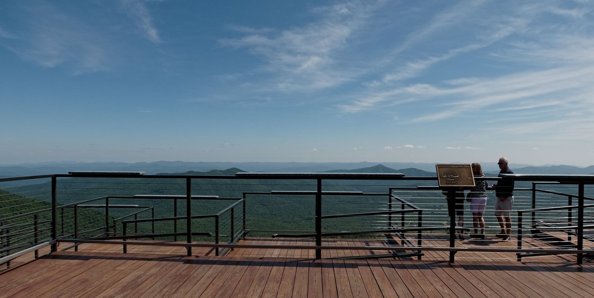
The view from the Pisgah Inn deck:
Be prepared for fog or rain. And it's often 15 degrees colder at the high elevations.
I followed these weather station / forecast sites before my trip last year, and got perfect warm, sunny weather.
Mt Mitchell.
https://www.mountain-forecast.com/pe...forecasts/2037
https://www.wunderground.com/persona...?ID=KNCBURNS20
The road up to Mt Mitchell is steeper than the Parkway, with lots of 8% or higher grades.
The view from the Pisgah Inn deck:
Last edited by rm -rf; 02-15-19 at 03:42 PM.
02-17-19, 10:06 PM
#18
Let's do a Century

Join Date: Oct 2004
Location: North Carolina
Posts: 8,316
Bikes: Cervelo R3 Disc, Pinarello Prince/Campy SR; Cervelo R3/Sram Red; Trek 5900/Duraace, Lynskey GR260 Ultegra
Liked 879 Times
in
408 Posts
I’ve ridden all of Skyline Drive and the BRP. My brother and I rode it end to end in 7 days a few years ago. It might help to know that there isn’t anything steep on any of the 500-600 mile route.
We rode all of Skyline Drive on day 1. There is a LOT of climbing on that stretch. We did 115 miles with 11,000’ of climbing. Skyline really doesn’t get to the elevations with the great views but there were a lot of hills. Based on that and what you have in mind if it were me I’d choose other sections. Here are some suggestions:
Peaks of Otter is one of my favorite spots along the BRP. Its in VA and not too far from Roanoke by car. I’d suggest spending a night or two there and doing some rides from there. The longest climb on the BRP at 13 miles is north of there. South is more rolling. They have a nice restaurant and some fun hiking trails. You need reservations.
Pisgah Inn is another option. Asheville is not too far from there. You could spend a night or two there and ride the BRP south for some good hills. If you go north you’d descend a long hill and have to reclimb it.
For great scenery in my opinion the area around Waterrock Knob near the southern end is hard to beat. You could stay in Maggie Valley or Cherokee and drive to an overlook and do some out and backs.
The BRP around Asheville is too busy and not scenic. But Asheville would be a great place to visit. Lots to do downtown plus the Biltmore House.
There is a neat town off the BRP in VA called Floyd. You could stay in Hotel Floyd and do some riding from there, maybe to Maybry Mill. Not great views but nice riding.
I’ve climbed to Mitchell from both directions and it’s a lot of climbing. It’s very doable but you need to allow plenty of time.
If you get closer to planning and need more details just let me know.
__________________
Ride your Ride!!
Ride your Ride!!
02-20-19, 07:41 PM
#20
Senior Member
Thread Starter
Thank you [MENTION=20395]jppe[/MENTION] and others who have provided info. My take away is to skip Skyline and spend the extra day on the BRP. No shortage of options - in the mean time I'll continue to mull them over. I'll post photos in October, assuming I don't get run over by one of the Leaf Peepers. lol
02-20-19, 09:35 PM
#21
Let's do a Century
Join Date: Oct 2004
Location: North Carolina
Posts: 8,316
Bikes: Cervelo R3 Disc, Pinarello Prince/Campy SR; Cervelo R3/Sram Red; Trek 5900/Duraace, Lynskey GR260 Ultegra
Liked 879 Times
in
408 Posts
A great little ride would be a loop from Blowing Rock. There is a public garage plus public parking on some side streets there. Essentially you’d take Hwy 221 from Blowing Rock to where it connects with the BRP near Grandfather Mountain. You’d then jump on the BRP and head north back to Shulls Mill Rd to Hwy 221 back to Blowing Rock. This would allow you to ride across the Viaduct. The ride on 221 is mostly through wooded areas and generally not too much traffic if it’s not leaf season, but there are some hills. If your wife didn’t want to ride the whole loop she could take Holloway Mtn road to cut the mileage in half.
If if you wanted to add miles you could ride further south on the BRP towards Linville Falls. It’s reasonably flat, at least no long climbs. If you wanted to do a good fun local climb you’d descend Shulls Mill Rd down to Hwy 105 and then climb it back to the BRP. I think you’d enjoy it. Probably 6% and lots of twists and all wooded for about 6 miles.
Lots of restaurants and shops in Blowing Rock and is a good tourist town. Boone is nearby and has lodging and more restaurants. If you opt for that area let me know as my daughter lives there. I can suggest local restaurants that we like when we’re up there.
__________________
Ride your Ride!!
Ride your Ride!!
03-01-19, 02:17 PM
#22
Junior Member
Also consider staying in Brevard and riding 276 up to the Parkway...or out of Brevard on 64, up 215 to the Parkway, and down the other side. Less traffic than the Parkway, great climbs and views...just plain awesome. Couple of great bike shops in Brevard too...Sycamore is our favorite..coffee shop, great guys who work there..and a couple beers on tap. There is also the Hub , which has a bit more of a "scene" per se with outdoor patio with beer, food trucks, and lots of cyclists coming off the trails!
03-02-19, 11:57 AM
#23
Senior Member
A friend spent a lot of time in western NC last fall noted some new harsh chipseal being put on the BRP southern end.
Have any of the prior commenters ridden that part since late October? Sometimes chipseal is a precursor to a better
layer of asphalt but November et seq would not be a good time for asphalt to be laid down. This would be useful to know.
Have any of the prior commenters ridden that part since late October? Sometimes chipseal is a precursor to a better
layer of asphalt but November et seq would not be a good time for asphalt to be laid down. This would be useful to know.
03-04-19, 12:48 PM
#24
Senior Member
A friend spent a lot of time in western NC last fall noted some new harsh chipseal being put on the BRP southern end.
Have any of the prior commenters ridden that part since late October? Sometimes chipseal is a precursor to a better
layer of asphalt but November et seq would not be a good time for asphalt to be laid down. This would be useful to know.
Have any of the prior commenters ridden that part since late October? Sometimes chipseal is a precursor to a better
layer of asphalt but November et seq would not be a good time for asphalt to be laid down. This would be useful to know.
Last edited by DeceptivelySlow; 03-04-19 at 01:00 PM.
03-05-19, 07:43 AM
#25
don't try this at home.
BRP chip seal
I was there last summer. They had just finished sections in the Richland Balsam - Pisgah Inn area. There were still temporary lighted signs telling cyclists and motorcycles to avoid the new chipseal. But it was actually completed, they hadn't removed the signs yet. The BRP web site showed general areas where chipseal was scheduled, but not the exact mile markers.
Compared to my local midwest chipseal, it's not nearly as bad. The gravel sizes are "moderate" instead of "thumb sized" like some local counties do. And the sealer tar coat avoids loose gravel, which takes months to go away on our local chipseal.
I found it "buzzy" when climbing. I have large volume tires, around 28-29mm, at lower air pressures, which help. I stopped noticing it after a while, but the difference when I got to an older, smooth section was surprising. Like DeceptivelySlow mentioned, it's noisier on car tires. I could hear them coming--good, I guess.
On downhills, the speed smooths it out, not bad at all. I slowed a bit in the turns, not completely sure of the traction yet.
I expect after a year it'll be smoother where the car tires wear it down, and two years later, even better, but still not like regular paving. That's what happens around here.
Last edited by rm -rf; 03-05-19 at 07:55 AM.