


Comments/Suggestions on route from Bucks County, PA to Rodanthe, NC (OBX)
 01-12-21, 03:41 PM
#1
Comments/Suggestions on route from Bucks County, PA to Rodanthe, NC (OBX)
I am planning a trip from Langhorne, Bucks County, PA this summer down to Rodanth, NC on the outer banks. With hopes that the ferries, bridge shuttles, etc. open back up, I plan to cross into NJ and ride down the center of the state, along the DelMarVa, and along the coast in NC.
Anyone have any comments or suggestions regarding the route below which I have put together? Obviously i don't know most of these roads from a riding perspective, so i'm trying to pool together as much information as I can before hand.
Thanks in advance.
https://www.komoot.com/tour/288592314?ref=wtd
Last edited by J.Owen; 02-01-21 at 03:18 PM.
 01-15-21, 10:06 AM
#2
At a glance, your run into a big problem crossing Great Egg Inlet between Somers Point and Beesley's Point unless you have pontoons on your bike. That was U.S. 9 that crossed via a private causeway and drawbridge. Several years ago the state acquired it with the goal of rehabbing it. However, it turned out that the structure needed a lot more work than believed. The project was scrapped, the draws span and causeway were removed and I think part of it was turned into a fishing pier. Google Maps does not show it existing anymore. U.S. 9 now combines with the Garden State Parkway to cross the inlet. Don't know if it's now bike-legal. (There used to be no shoulders.) Even if it is, I wouldn't want to ride it. You'd be better off going into OC using NJ 52 and heading south from there via CR 619 (West then Bay Avenues) across Corson's Inlet and continue down the coast. Getting through Strathmere sort of sucks because of a narrow road, Sea Isle is tolerable. Avalon and Stone Harbor are much better because there is a wide street with a good bike lane. Take Dune Drive starting in Avalon, not CR 619. It becomes 2nd Ave.in Stone Harbor. You will eventually need to hang a right to get back on CR 619 to cross the back bay to get to NJ 147 which takes you into N. Wildwood. The only other way to cross the Great Egg River is to go way inland to the May's Landing area.
You want to stay off U.S. 9 as much as possible. Certainly in the summer. For example, where you get on in Clermont from NJ 83 sucks. My ex-GF has a house in Avalon. We used to see accidents on that stretch fairly frequently. Mostly rearenders when someone slows down to turn into a parking lot and the person behind is not paying attention.
That "road" on your map labeled "AC Electric Co" appears to be a sand road for ACE to access its power lines. I have no prior experience with Komoot, but I suggest looking at the root on Google Maps. The Street View option can give you a visual idea of actual conditions.
Finally, have you looked into Adventure Cycling's Atlantic Coast Route? IIRC, further south it has an Outer Banks option.
 01-20-21, 02:43 PM
#3
I think I know nothing.
In total agreement with staying off Rt 9
01-23-21, 09:10 AM
#4
BTW...Cape Henlopen State Park in Lewes. DE is terrific, but you�d do yourself a favor by reserving a campsite in advance in the summer. Well in advance in the spring and summer, and there will likely be a two night minimum. Maybe 5 or 6 years ago I stayed there Easter weekend and the place was nearly full.
01-28-21, 01:17 PM
#5
Full Member
Join Date: May 2017
Location: Washington, DC
Posts: 480
Bikes: Trek Domane 4.3
Liked 53 Times
in
38 Posts
I'm familiar with the roads from Rehoboth Beach to north of Ocean City. I think along what you have you'll be fine . . . it's really a great place to bike because for the most part shoulders are wide or the roads are pretty unused. Drivers are pretty courteous. I might suggest some small tweaks in there - mainly from Bethany south - to stay off Roxana Road, which is pretty busy, and just use some of the roads near it.
Also, try to avoid this area on Saturday in the summer, which is the day that most rentals switch over, meaning a lot of traffic coming and going out.
Noodled this up on ride with GPS. https://ridewithgps.com/routes/35099426
Also, try to avoid this area on Saturday in the summer, which is the day that most rentals switch over, meaning a lot of traffic coming and going out.
Noodled this up on ride with GPS. https://ridewithgps.com/routes/35099426
Last edited by drewguy; 01-29-21 at 12:55 PM.
01-28-21, 01:22 PM
#6

Senior Member
Join Date: Aug 2006
Location: Valley Forge: Birthplace of Freedom
Posts: 1,306
Bikes: Novara Safari, CAAD9, WABI Classic, WABI Thunder
Liked 460 Times
in
241 Posts
Don't have any knowledge as to roads, but it sounds like a sweet trip. Hope you have fun!
__________________
Be watchful, stand firm in the faith, act like men, be strong. Let all that you do be done in love.
Be watchful, stand firm in the faith, act like men, be strong. Let all that you do be done in love.
02-01-21, 03:32 PM
#7
I did see this and are using most of this route from Virgina Beach to Rodanthe. The AC route comes in from Richmond, so we had to modify slightly as we will be traveling in from the north and therefore need to traverse Virgina Beach a little more.
02-01-21, 03:40 PM
#8
I'm familiar with the roads from Rehoboth Beach to north of Ocean City. I think along what you have you'll be fine ... Noodled this up on ride with GPS. https://ridewithgps.com/routes/35099426
02-01-21, 03:41 PM
#9
Likes For J.Owen:
02-01-21, 06:45 PM
#10
Unless you have friends in Avalon, it will probably be easier to find accommodations in Ocean City, Eating out will also be more reasonable. But keep in mind that it�s a dry town. That�s why there are big liquor stores in the mainland at NJ 52 and before the 34th St. bridge.
02-01-21, 07:44 PM
#11
I actually have a couple options in ocean city, as well as some of the other towns. At this point I will need to see who�s renting out or not that weekend.
The two night minimum is part of the reason we�re heading inland for the second night. Still a lot of planning to do, but this is helpful.
The two night minimum is part of the reason we�re heading inland for the second night. Still a lot of planning to do, but this is helpful.
02-01-21, 07:59 PM
#12

don't try this at home.

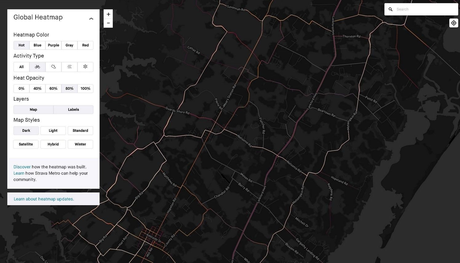
For unfamiliar places, I like to check the Strava Heat Map. It's two years of recorded strava rides, with the roads colored by popularity. (700 million miles in the USA per year!)
If a road is much less traveled than nearby roads, that's a sign the cyclists are avoiding it. Usually due to traffic. The strava riders will climb anything, so steep grades can also show as popular.
You can bookmark the current view since the URL changes as you pan and zoom. But you need to click the "Labels" button to see street and town names.
The map recolors the roads as you zoom, since cities have way more activity than rural areas.
Here's the peninsula view, with big differences between roads. The white hot ones are way more popular than the dim red ones.
https://www.strava.com/heatmap#12.36...83539/hot/ride
