


AADT Maps for Canada??
 11-16-23, 10:19 PM
#1
Full Member
Thread Starter
AADT Maps for Canada??
I am trying to plan a tour for next summer that goes from Portland, ME, to St. John's, NL. I can't seem to find a map (pdf, GIS, paper, etc.) that shows the AADT (Average Annual Daily Traffic) count on the map for any of the eastern Provinces. I can get a pdf of the data in a LIST format and then a MAP showing where the various AADT stations are located. That is a royal PIA to manually cross-reference. Does anyone know of an AADT map for the Provinces New Brunswick and eastward and if so, can you provide a link to the information? Thanks!
Tailwinds, John
Tailwinds, John
 11-17-23, 10:00 AM
#2
Senior Member
Join Date: Aug 2010
Location: Madison, WI
Posts: 11,568
Bikes: 1961 Ideor, 1966 Perfekt 3 Speed AB Hub, 1994 Bridgestone MB-6, 2006 Airnimal Joey, 2009 Thorn Sherpa, 2013 Thorn Nomad MkII, 2015 VO Pass Hunter, 2017 Lynskey Backroad, 2017 Raleigh Gran Prix, 1980s Bianchi Mixte on a trainer. Others are now gone.
Liked 1,589 Times
in
1,230 Posts
I am trying to plan a tour for next summer that goes from Portland, ME, to St. John's, NL. I can't seem to find a map (pdf, GIS, paper, etc.) that shows the AADT (Average Annual Daily Traffic) count on the map for any of the eastern Provinces. I can get a pdf of the data in a LIST format and then a MAP showing where the various AADT stations are located. That is a royal PIA to manually cross-reference. Does anyone know of an AADT map for the Provinces New Brunswick and eastward and if so, can you provide a link to the information? Thanks!
Tailwinds, John
Tailwinds, John
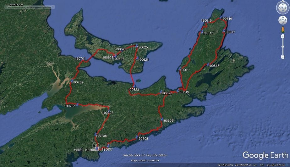
The numbers on the map are the dates (YYMMDD) that I stayed at different places for the night, so it would be best to answer questions between different dates. I started and ended at Halifax. Some of my travels were on gravel trails. I clearly remember one day that I got on a road that I wanted to get off of at the next exit, but other than that, I felt that all of the roads that I was on were easily traveled by bike.
I think I still have my GPS tracks in GPX format.
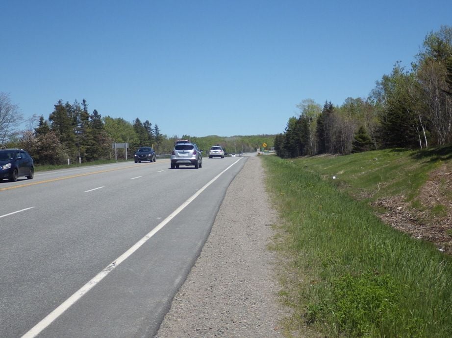
Photo below is the road that I got onto that I would recommend avoiding. I was only on the Trans Canada for a few miles that day, June 10, I can easily find that on a map. It is between 190609 and 190619 on the map. (I stayed at the same campground on 190610 and again on 190619).
Part of the Canso Causeway has no shoulder, you are in the traffic lane. I waited until I saw no traffic coming from behind me to cross both times, otherwise the Causeway was uneventful. Causeway is in the background in the photo below.
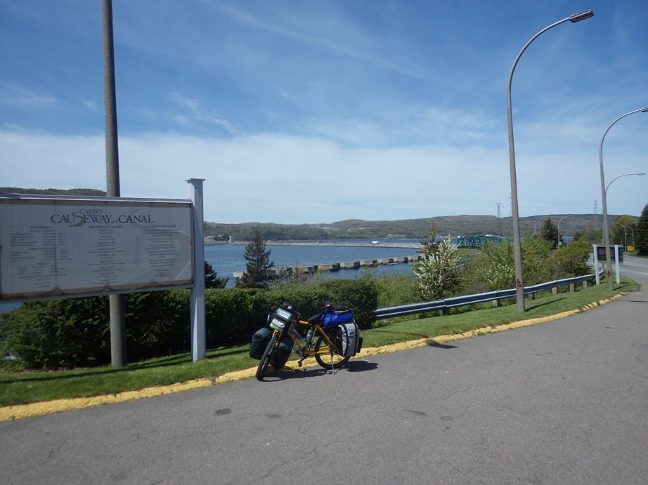
Your profile says you have a Nomad Mk II, my Mk II is in the above photo.
Have a great trip.
11-17-23, 10:37 AM
#3
Full Member
Thread Starter
I can't help with that, but if you have any questions about the roads that I rode on in 2019, I can answer your questions about my observations. (If I do not remember riding on any particular road, that probably is a good sign.)
The numbers on the map are the dates (YYMMDD) that I stayed at different places for the night, so it would be best to answer questions between different dates. I started and ended at Halifax. Some of my travels were on gravel trails. I clearly remember one day that I got on a road that I wanted to get off of at the next exit, but other than that, I felt that all of the roads that I was on were easily traveled by bike.
I think I still have my GPS tracks in GPX format.
Photo below is the road that I got onto that I would recommend avoiding. I was only on the Trans Canada for a few miles that day, June 10, I can easily find that on a map. It is between 190609 and 190619 on the map. (I stayed at the same campground on 190610 and again on 190619).
Part of the Canso Causeway has no shoulder, you are in the traffic lane. I waited until I saw no traffic coming from behind me to cross both times, otherwise the Causeway was uneventful. Causeway is in the background in the photo below.
Your profile says you have a Nomad Mk II, my Mk II is in the above photo.
Have a great trip.
Yep, I have too many bikes. Don't ride the Thorn as often as it is my "off road" touring bike. It handles great on off road (an on) but gotta say it is a lot slower than other bikes not designed to go off road. My dedicated off road tours usually are only a week or two a year vs. the others get used on tour for 2-4 months a year.
Again, thanks for the info!
11-17-23, 07:01 PM
#4
Senior Member
Join Date: Aug 2010
Location: Madison, WI
Posts: 11,568
Bikes: 1961 Ideor, 1966 Perfekt 3 Speed AB Hub, 1994 Bridgestone MB-6, 2006 Airnimal Joey, 2009 Thorn Sherpa, 2013 Thorn Nomad MkII, 2015 VO Pass Hunter, 2017 Lynskey Backroad, 2017 Raleigh Gran Prix, 1980s Bianchi Mixte on a trainer. Others are now gone.
Liked 1,589 Times
in
1,230 Posts
Yeah, the short distance that I wanted to get off teh road was Trans Canada.
People cautioned me against riding across the Canso Causeway, but as I noted it was uneventful, no problem at all. But I did wait for all following traffic to pass first. There was not a strong side wind the days I rode across it.
People cautioned me against riding across the Canso Causeway, but as I noted it was uneventful, no problem at all. But I did wait for all following traffic to pass first. There was not a strong side wind the days I rode across it.
11-17-23, 07:02 PM
#5
Senior Member
Join Date: Aug 2010
Location: Madison, WI
Posts: 11,568
Bikes: 1961 Ideor, 1966 Perfekt 3 Speed AB Hub, 1994 Bridgestone MB-6, 2006 Airnimal Joey, 2009 Thorn Sherpa, 2013 Thorn Nomad MkII, 2015 VO Pass Hunter, 2017 Lynskey Backroad, 2017 Raleigh Gran Prix, 1980s Bianchi Mixte on a trainer. Others are now gone.
Liked 1,589 Times
in
1,230 Posts
Oops, duplicate post.
 11-20-23, 09:00 AM
#7
Full Member
Thread Starter
That is what I thought but I know some eastern Provinces do not, at least to emails from the Nova Scotia transportation department. I am waiting on replies from New Brunswick, PEI, and Newfoundland & Labrador. Tailwinds, John
