


Roads You Really Shouldn't Ride in North America
 06-14-23, 07:06 AM
#1

Hooked on Touring
Thread Starter
Roads You Really Shouldn't Ride in North America
I'm not talking about unpleasant -
Or steep, or without any services, or boring.
I'm talking about downright dangerous.
Please, identify the road by its name and location,
then explain why it is so dangerous.
I'll start ...
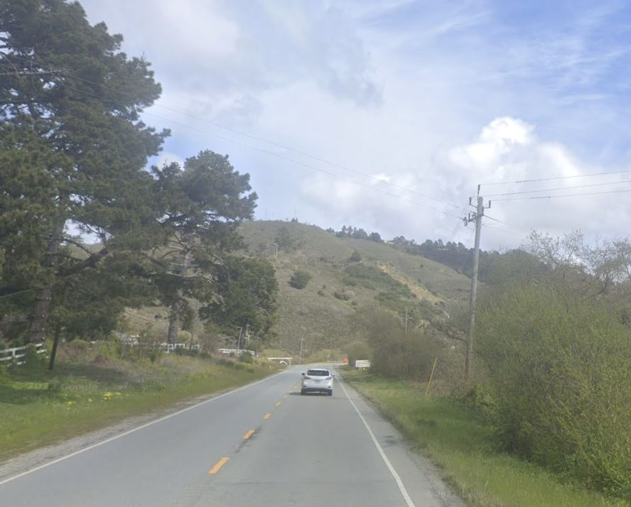
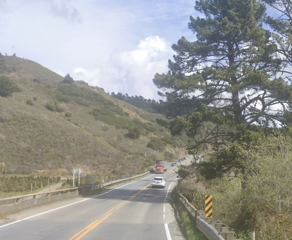
My nomination is US 191 in Montana between Bozeman and West Yellowstone.
This highway travels through the stunning Gallatin Canyon via the resort town of Big Sky.
US 191 has high, fast-moving traffic, no shoulders, and guardrails that limit escape, if necessary.
It is very curvy, so sight lines are limited. And deep shady sections make cyclists less visible.
It may be environmentally difficult to update this highway,
but there seem to be room for multiillion dollar houses.
I road this highway in 1987 and was amazed by the beauty of the canyon.
I oad it again in 2022 and thought I was going to die.
US 191 between Big Sky and Bozeman
Or steep, or without any services, or boring.
I'm talking about downright dangerous.
Please, identify the road by its name and location,
then explain why it is so dangerous.
I'll start ...
My nomination is US 191 in Montana between Bozeman and West Yellowstone.
This highway travels through the stunning Gallatin Canyon via the resort town of Big Sky.
US 191 has high, fast-moving traffic, no shoulders, and guardrails that limit escape, if necessary.
It is very curvy, so sight lines are limited. And deep shady sections make cyclists less visible.
It may be environmentally difficult to update this highway,
but there seem to be room for multiillion dollar houses.
I road this highway in 1987 and was amazed by the beauty of the canyon.
I oad it again in 2022 and thought I was going to die.
US 191 between Big Sky and Bozeman

Likes For jamawani:
06-14-23, 07:50 AM
#2
Bike touring webrarian
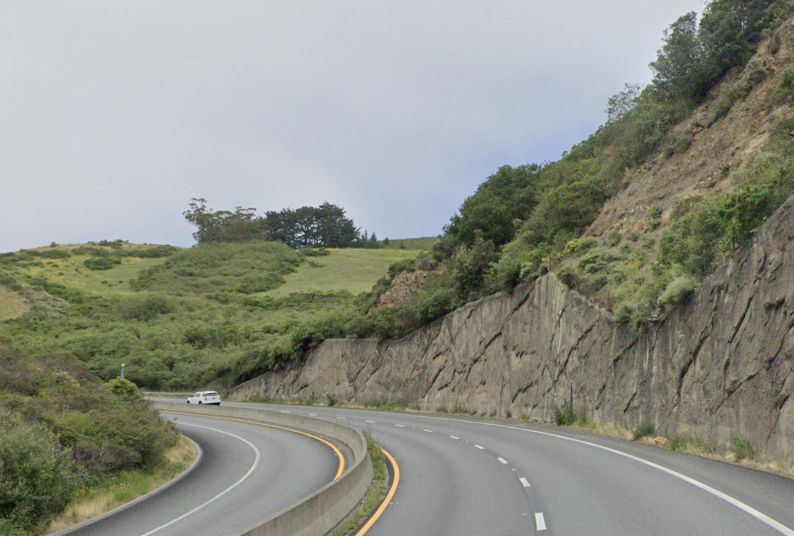
Highway 1 just south of Pacifica. Uphill stretch with very little shoulder. I've never ridden it as it seemed too dangerous for me. There is a stoplight at the bottom of the hill, so maybe time the light to ride between clumps of cars.
Highway 1 through Laguna Beach. There isn't enough asphalt between the parked cars and moving traffic to ride safely. Getting doored a real risk. I've ridden it several times and each time I was scared.
Highway 1 through Laguna Beach. There isn't enough asphalt between the parked cars and moving traffic to ride safely. Getting doored a real risk. I've ridden it several times and each time I was scared.
06-14-23, 08:44 AM
#3
Senior Member
Join Date: May 2017
Location: Hacienda Hgts
Posts: 2,109
Bikes: 1999 Schwinn Peloton Ultegra 10, Kestrel RT-1000 Ultegra, Trek Marlin 6 Deore 29'er
Mentioned: 3 Post(s)
Tagged: 0 Thread(s)
Quoted: 822 Post(s)
Liked 1,961 Times
in
944 Posts
Highway 1 just south of Pacifica. Uphill stretch with very little shoulder. I've never ridden it as it seemed too dangerous for me. There is a stoplight at the bottom of the hill, so maybe time the light to ride between clumps of cars.
Highway 1 (PCH) through Laguna Beach. There isn't enough asphalt between the parked cars and moving traffic to ride safely. Getting doored a real risk. I've ridden it several times and each time I was scared.
Highway 1 (PCH) through Laguna Beach. There isn't enough asphalt between the parked cars and moving traffic to ride safely. Getting doored a real risk. I've ridden it several times and each time I was scared.
Laguna Beach is bad but there are inland work arounds.
Best practice in Laguna Beach is to ride through there before the shops open on a weekend/holiday morning, and take the sharrow lanes as a group to stay out of the door zone.
Likes For CAT7RDR:
06-14-23, 09:43 AM
#4
Newbie
Join Date: Jun 2023
Location: Sacramento, CA region
Posts: 2
Mentioned: 0 Post(s)
Tagged: 0 Thread(s)
Quoted: 2 Post(s)
Likes: 0
Liked 1 Time
in
1 Post
Fortunately, I recently validated an alternate - there is a dirt trail you can see on the right up into the forest as you start ascending the hill, just after the stop light. The trail is accessed from the Ace Hardware right next to Hwy 1. A short 150 yards or so of hike-a-bike, and then the gravel trail is ridable to the top of the hill (via right turn on Arroyo trail), then down (a little more more hike-a-bike) to the Devil's Slide driveway - Hwy 1 avoided thru there.
Likes For PCHthx:
06-14-23, 11:23 AM
#5
Senior Member
Join Date: Jan 2010
Posts: 39,246
Mentioned: 211 Post(s)
Tagged: 1 Thread(s)
Quoted: 18420 Post(s)
Liked 15,564 Times
in
7,333 Posts
The NJ Turnpike. 
Likes For indyfabz:
06-14-23, 12:39 PM
#6
Senior Member

Join Date: Mar 2011
Posts: 3,094
Mentioned: 7 Post(s)
Tagged: 0 Thread(s)
Quoted: 1034 Post(s)
Liked 1,290 Times
in
743 Posts
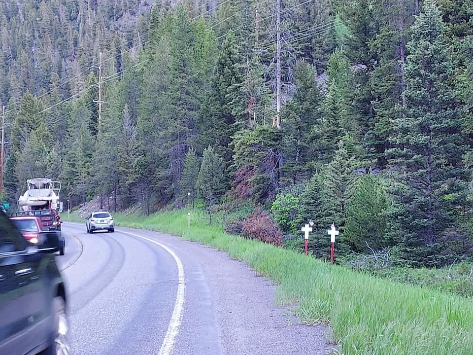
I was headed to Indian Trail Campground in New London, Ohio, and took 13 South out of Norwalk, Ohio. It was probably the scariest ride I have ever had on a bicycle, and where I live it is pretty bad. The road had absolutely no shoulder to speak of, you had less than a foot on the side of the road that didn't have the ground rumble strip. After that there was a steep, deep ditch, that had almost a vertical wall. The road is heavily traveled by big trucks and large dump trucks, the type used for hauling coal. The trucks would be right next to you as they passed, no fault of the drivers, that was simply all they could do. By the time I got to the road, there was no other good option. I made it, but it was the worst part of my trip.
06-14-23, 07:16 PM
#7
bicycle tourist
Anywhere close to Canton Ohio 
Perhaps I passed through on a bad day but in my travels through the US so far, but the day I rode through Canton I had the largest combination of no shoulders and obnoxious drivers. A vast majority of motorists everywhere are patient and polite and you remember the jerks and Canton had the most of those memories.
Now if you go a little ways from Canton, I found delightful country roads with many cycling groups out - and not too far the other side the Ohio To Erie Trail (OTET) comes through with reasonable cycling. It was surface roads through Canton and drivers there-upon that I remember as worst so far.
06-14-23, 07:28 PM
#8
ret'd msgr
Join Date: Aug 2007
Location: upstate
Posts: 117
Mentioned: 0 Post(s)
Tagged: 0 Thread(s)
Quoted: 31 Post(s)
Likes: 0
Liked 16 Times
in
10 Posts
Most of Virginia, except tiny areas around Richmond.
No shoulders on any roads or bridges, almost all vehicles are large trucks or huge SUVs, all vehicles always going at least 20-30 miles over posted speed limits, almost all vehicles inhabited by angry folks who resent cyclists.
The only place i have ever been shot at while riding (to be fair, they clearly did aim to miss; their goal was to terrorize, not to hit us), or had beer cans thrown at me while riding.
Likes For ignant666:
06-15-23, 06:06 AM
#10
Senior Member
06-15-23, 08:08 AM
#12
Bike touring webrarian
There is a bypass, up the hill, for the first part of Laguna Beach. But, once you get far enough south, the bypass merges into Highway 1 and there are no alternatives.
06-15-23, 02:59 PM
#13
Senior Member
Join Date: Dec 2010
Location: northern Deep South
Posts: 8,904
Bikes: Fuji Touring, Novara Randonee
Mentioned: 36 Post(s)
Tagged: 0 Thread(s)
Quoted: 2604 Post(s)
Liked 1,933 Times
in
1,213 Posts
 06-15-23, 05:41 PM
#14
Junior Member
"Approaching the Tom Lantos Tunnel the directions stated "Use caution approaching tunnel." They weren't kidding. The road climbed steeply uphill for a mile or so with blind corners, narrow lanes, and only a foot or so of "shoulder." I walked it with the bike between me and the traffic and had to stop and get off the road a few times when big trucks passed."
06-15-23, 05:48 PM
#15
Junior Member
Anywhere close to Canton Ohio
Perhaps I passed through on a bad day but in my travels through the US so far, but the day I rode through Canton I had the largest combination of no shoulders and obnoxious drivers. A vast majority of motorists everywhere are patient and polite and you remember the jerks and Canton had the most of those memories.
Perhaps I passed through on a bad day but in my travels through the US so far, but the day I rode through Canton I had the largest combination of no shoulders and obnoxious drivers. A vast majority of motorists everywhere are patient and polite and you remember the jerks and Canton had the most of those memories.
The Perry Motel. THe police were out at 11pm looking for the occupant of the room two doors down.
06-15-23, 06:53 PM
#16
Senior Member
Join Date: Jan 2010
Posts: 39,246
Mentioned: 211 Post(s)
Tagged: 1 Thread(s)
Quoted: 18420 Post(s)
Liked 15,564 Times
in
7,333 Posts
Believe it or not, I and some friends were headed to a Delaware shore town many years ago when we drove passed a guy we knew who was riding his bike on I-95 a bit south of the city. He was a bit touched in the head. The next time I saw him he told me a state trooper put an end to that.
06-15-23, 07:26 PM
#17
ignominious poltroon

Join Date: Jan 2022
Posts: 4,045
Mentioned: 3 Post(s)
Tagged: 0 Thread(s)
Quoted: 2241 Post(s)
Liked 3,443 Times
in
1,802 Posts
My kid is living in Bozeman and wanted to get a job at Big Sky bike park for the summer. He would have had to make this his commute. We were relieved he didn't get the job (they want people to live locally, and he is tied to a lease).
It is bad enough by car.
06-15-23, 08:05 PM
#18

don't try this at home.

Join Date: Jan 2006
Location: N. KY
Posts: 5,940
Mentioned: 10 Post(s)
Tagged: 0 Thread(s)
Quoted: 974 Post(s)
Liked 512 Times
in
352 Posts
I was headed to Indian Trail Campground in New London, Ohio, and took 13 South out of Norwalk, Ohio. It was probably the scariest ride I have ever had on a bicycle, and where I live it is pretty bad. The road had absolutely no shoulder to speak of, you had less than a foot on the side of the road that didn't have the ground rumble strip. After that there was a steep, deep ditch, that had almost a vertical wall. The road is heavily traveled by big trucks and large dump trucks, the type used for hauling coal. The trucks would be right next to you as they passed, no fault of the drivers, that was simply all they could do. By the time I got to the road, there was no other good option. I made it, but it was the worst part of my trip.
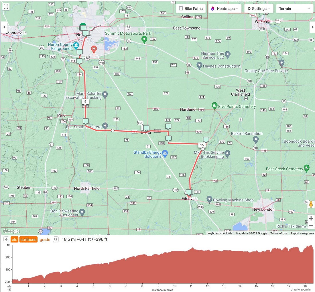
I looked up the route in ridewithgps.com, with the rider heatmap turned on. This highlights popular cycling roads, and shows US-250 is rarely or never ridden. I think the rwgps heatmap option requires a paid subscription?
Clicking the endpoints, it proposed heading east to Collins, then south on back roads. But the first miles were tagged as gravel, and satellite view shows it is gravel.
This route follows popular roads, and checking the west-east portion, it's paved.
~~~~~~~~~~~~
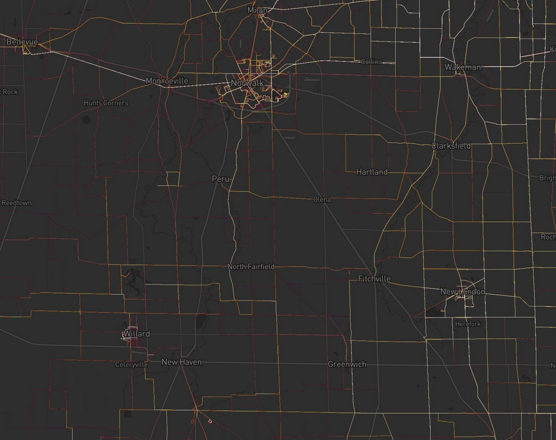
The free version of the Strava Heat map limits how far it can zoom in. But this free zoom level is good enough to plan this route. gray=no activity, dim red= low activity, white hot=most popular.
I note that the gravel road heading east from Norwalk is popular. Perhaps it's on a popular gravel ride route?
That diagonal road is US-250, and there's no activity on it. I actually watch out for very low activity roads with other nearby roads that have ride activity -- there's a reason why cyclists are avoiding it.
If I didn't mind adding a few miles and some more climbing, I'd take the road following the creek valley southward from Norwalk, passing near Peru OH. It's probably more scenic, and maybe shady in spots.
Last edited by rm -rf; 06-15-23 at 08:09 PM.
06-15-23, 08:07 PM
#19
Senior Member
Join Date: May 2021
Location: San Francisco
Posts: 2,039
Bikes: addict, aethos, creo, vanmoof, sirrus, public ...
Mentioned: 2 Post(s)
Tagged: 0 Thread(s)
Quoted: 1279 Post(s)
Liked 1,393 Times
in
711 Posts
Highway 1 just south of Pacifica. Uphill stretch with very little shoulder. I've never ridden it as it seemed too dangerous for me. There is a stoplight at the bottom of the hill, so maybe time the light to ride between clumps of cars.
Highway 1 through Laguna Beach. There isn't enough asphalt between the parked cars and moving traffic to ride safely. Getting doored a real risk. I've ridden it several times and each time I was scared.
Highway 1 through Laguna Beach. There isn't enough asphalt between the parked cars and moving traffic to ride safely. Getting doored a real risk. I've ridden it several times and each time I was scared.
That is probably the most dangerous mile on the entire Pacific coast. There are two corners, and the second one is blind with no shoulder and the hill comes right down to the pavement, so no where to go but occupy part of the lane shared with heavy, high-speed traffic. I have managed to dart thru it by stopping on the side and waiting for a break, but I always get gassed and have to check my shorts after getting thru.
Fortunately, I recently validated an alternate - there is a dirt trail you can see on the right up into the forest as you start ascending the hill, just after the stop light. The trail is accessed from the Ace Hardware right next to Hwy 1. A short 150 yards or so of hike-a-bike, and then the gravel trail is ridable to the top of the hill (via right turn on Arroyo trail), then down (a little more more hike-a-bike) to the Devil's Slide driveway - Hwy 1 avoided thru there.
Fortunately, I recently validated an alternate - there is a dirt trail you can see on the right up into the forest as you start ascending the hill, just after the stop light. The trail is accessed from the Ace Hardware right next to Hwy 1. A short 150 yards or so of hike-a-bike, and then the gravel trail is ridable to the top of the hill (via right turn on Arroyo trail), then down (a little more more hike-a-bike) to the Devil's Slide driveway - Hwy 1 avoided thru there.
If you are talking about the mile or two uphill to the Tom Lantos tunnels I walked it. And I have a reasonable tolerance for traffic when I need to deal with it.
"Approaching the Tom Lantos Tunnel the directions stated "Use caution approaching tunnel." They weren't kidding. The road climbed steeply uphill for a mile or so with blind corners, narrow lanes, and only a foot or so of "shoulder." I walked it with the bike between me and the traffic and had to stop and get off the road a few times when big trucks passed."
"Approaching the Tom Lantos Tunnel the directions stated "Use caution approaching tunnel." They weren't kidding. The road climbed steeply uphill for a mile or so with blind corners, narrow lanes, and only a foot or so of "shoulder." I walked it with the bike between me and the traffic and had to stop and get off the road a few times when big trucks passed."
on the other hand, as useful as it would be to connect many routes, i would NEVER ride CA-92 / San Mateo Road, connecting half moon bay and san mateo.
__________________

Likes For mschwett:
06-15-23, 08:09 PM
#20
Senior Member
Join Date: Mar 2011
Posts: 3,094
Mentioned: 7 Post(s)
Tagged: 0 Thread(s)
Quoted: 1034 Post(s)
Liked 1,290 Times
in
743 Posts
That road, OH-13, is also US-250, and it looks like the most direct route for vehicles to go south or southeast. Just that much information would get me to find alternate roads. I can see how mountain areas funnel all the traffic on just a few roads, and there's very limited alternate roads to choose. But in the midwest, it's more of a grid and some roads will be way better than this highway.
I looked up the route in ridewithgps.com, with the rider heatmap turned on. This highlights popular cycling roads, and shows US-250 is rarely or never ridden. I think the rwgps heatmap option requires a paid subscription?
Clicking the endpoints, it proposed heading east to Collins, then south on back roads. But the first miles were tagged as gravel, and satellite view shows it is gravel.
This route follows popular roads, and checking the west-east portion, it's paved.
~~~~~~~~~~~~
The free version of the Strava Heat map limits how far it can zoom in. But this free zoom level is good enough to plan this route. gray=no activity, dim red= low activity, white hot=most popular.
I note that the gravel road heading east from Norwalk is popular. Perhaps it's on a popular gravel ride route?
That diagonal road is US-250, and there's no activity on it. I actually look for very low activity roads with other nearby roads that have ride activity -- there's a reason why cyclists are avoiding it.
06-16-23, 04:30 AM
#21
bicycle tourist
I had plenty of information, what I didn't have was time, so that was the route. It was the fastest way that day, due to many reasons, some of which involved detours. I needed to get there before it got dark, and I wanted to get there before a really bad storm blew in. It is what it is.
I grew up in Colorado and went to school in New England and have since lived in Colorado, Oregon, California, Massachusetts and Texas. A little bit of a broad brush with exceptions but generally:
1. I started prior to use of smart phone or other dynamic planning. So generally either the roads were constrained by geography (hills/mountains) but I could look at a paper map and pick find either smaller more direct roads and find they either had minimal shoulders or relatively light traffic. True for most those places or even for early longer tours (e.g. going up the east coast from Key West to Halifax, Nova Scotia in 1995 - some exception with US 17 in South Carolina and US 1 into Miami but otherwise pretty good).
2. Presence of construction or detours can dynamically change cycling conditions on a road making it much tougher. Memorable examples come riding US 90 in LA where it paralleled I-10. This would have been a reasonable choice except there was road construction on I-10 and traffic got detoured to the parallel US 90.
So with that background, I can understand the situation you found yourself in - things changed to the route during the day and you picked a relatively direct road on the map that also didn't necessarily look like a huge highway.
My comment related to Canton Ohio had a few common elements (1) I had a route in the morning (2) road construction on that route suddenly made it less desirable so I adjusted (3) some of the roads I picked were relatively direct but not huge roads on the map (4) I found myself with no shoulder and a lot of traffic (5) in my case it was less huge trucks and more a set of impatient drivers.
06-16-23, 04:27 PM
#22
Senior Member
Join Date: Jan 2010
Posts: 39,246
Mentioned: 211 Post(s)
Tagged: 1 Thread(s)
Quoted: 18420 Post(s)
Liked 15,564 Times
in
7,333 Posts
The highway to hell.
Likes For indyfabz:
06-16-23, 05:08 PM
#23
Junior Member
I once had to shuttle a bike on Highway 163 between Mexican Hat and Bluff, Utah for some friends rafting on the San Juan River. Pretty scenery, but high speed desert traffic with lots of sections like this:
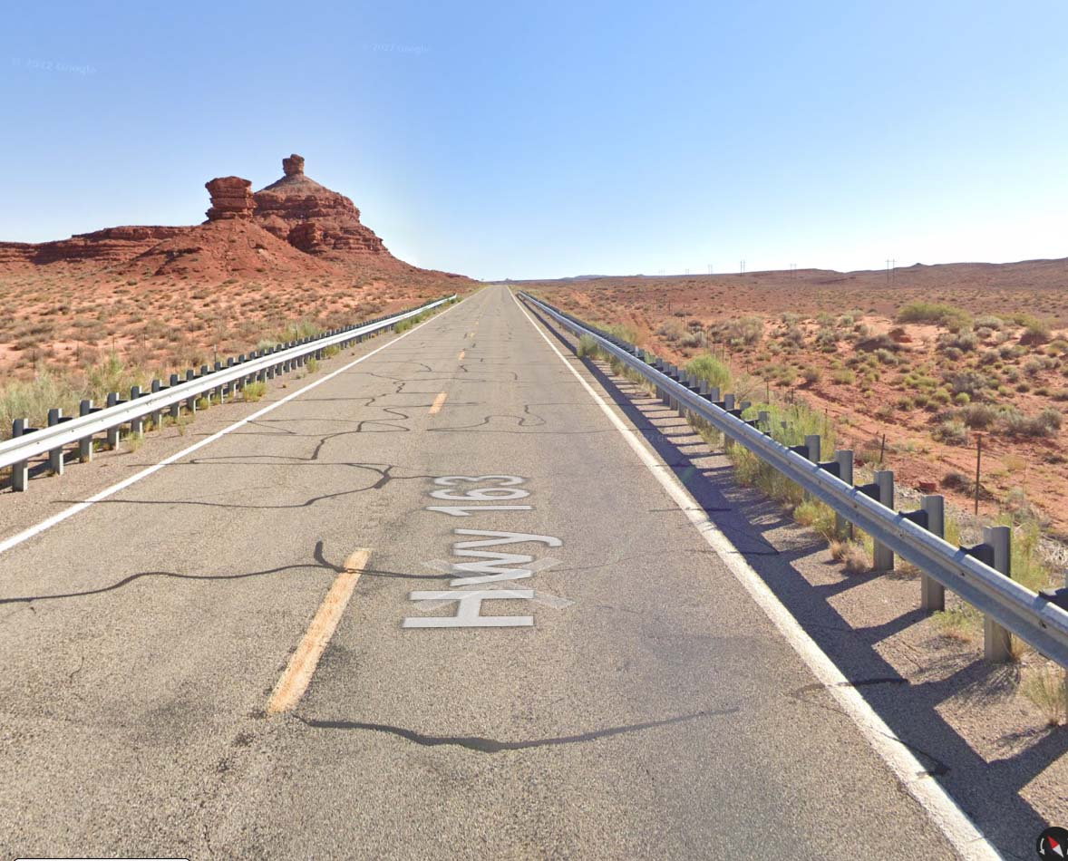
I really never want to ride there again.
I really never want to ride there again.
Likes For wayold:
06-16-23, 09:10 PM
#24
Senior Member
Join Date: Apr 2010
Location: Elevation 666m Edmonton Canada
Posts: 2,483
Bikes: 2013 Custom SA5w / Rohloff Tourster
Mentioned: 7 Post(s)
Tagged: 0 Thread(s)
Quoted: 1237 Post(s)
Liked 321 Times
in
248 Posts
My CAR got about 40 goat thorns there. LOL. Most of them when I pulled over to take pics at the Forrest Gump spot.
Saw one another day at the neato Chuckwagon General Store, on hwy 12 in Torrey Utah.
Saw one another day at the neato Chuckwagon General Store, on hwy 12 in Torrey Utah.
Last edited by GamblerGORD53; 06-16-23 at 09:21 PM.