


Garmin ascent data accuracy
 03-18-24, 08:08 AM
#1
Full Member
Thread Starter
Join Date: Jul 2018
Location: Raleigh, NC
Posts: 229
Mentioned: 1 Post(s)
Tagged: 0 Thread(s)
Quoted: 176 Post(s)
Liked 57 Times
in
36 Posts
Garmin ascent data accuracy
I had a couple of long group rides last weekend where my Garmin recorded the ascents of each one to be about 1,500 feet, but the route maps posted by the club sponsoring the rides showed the climbs to be about 2,200.
I believe the posted routes on https://ridewithgps.com/ are correct. Why would my Garmin record and show something so different?
I believe the posted routes on https://ridewithgps.com/ are correct. Why would my Garmin record and show something so different?
 03-18-24, 08:50 AM
#2
Senior Member
Join Date: May 2021
Posts: 8,451
Mentioned: 12 Post(s)
Tagged: 0 Thread(s)
Quoted: 4415 Post(s)
Liked 4,867 Times
in
3,012 Posts
I don�t think either are correct. The online route data is likely relying on contour interpolation, which can give odd results and the Garmin is measuring altitude indirectly with change in ambient pressure, which can be affected by the weather.
Likes For PeteHski:
03-18-24, 09:12 AM
#3
Senior Member
Join Date: Mar 2010
Posts: 1,659
Mentioned: 7 Post(s)
Tagged: 0 Thread(s)
Quoted: 1248 Post(s)
Liked 1,323 Times
in
674 Posts
I had a couple of long group rides last weekend where my Garmin recorded the ascents of each one to be about 1,500 feet, but the route maps posted by the club sponsoring the rides showed the climbs to be about 2,200.
I believe the posted routes on https://ridewithgps.com/ are correct. Why would my Garmin record and show something so different?
I believe the posted routes on https://ridewithgps.com/ are correct. Why would my Garmin record and show something so different?

Likes For Atlas Shrugged:
Likes For TakingMyTime:
03-18-24, 09:17 AM
#5

I'm good to go!
Join Date: Jul 2017
Location: Mississippi
Posts: 14,992
Bikes: Tarmac Disc Comp Di2 - 2020
Mentioned: 51 Post(s)
Tagged: 0 Thread(s)
Quoted: 6196 Post(s)
Liked 4,811 Times
in
3,319 Posts
A change 0.1 Hg or about 3.3 millibars of atmospheric pressure will change the reading on your device by 100 feet from whatever your cyclometer with barometric sensor established as the reference pressure for the ride. I go out on rides all the time and come home showing higher or lower elevation than when I left because of the changing atmospheric pressure during the day.
That might not be all your issue, might not be any of your issue.
That might not be all your issue, might not be any of your issue.
Likes For Iride01:
03-18-24, 09:27 AM
#6
Full Member
Thread Starter
Join Date: Jul 2018
Location: Raleigh, NC
Posts: 229
Mentioned: 1 Post(s)
Tagged: 0 Thread(s)
Quoted: 176 Post(s)
Liked 57 Times
in
36 Posts
Didn't know all this. Very interesting. Still surprising that the difference between the two in this case (2,200 vs. 1,500) is so significant. It affected my choice of group rides Sunday since I was not comparing apples to apples. Not complaining, but I found out something I didn't know.
03-18-24, 10:00 AM
#7
I'm good to go!
Join Date: Jul 2017
Location: Mississippi
Posts: 14,992
Bikes: Tarmac Disc Comp Di2 - 2020
Mentioned: 51 Post(s)
Tagged: 0 Thread(s)
Quoted: 6196 Post(s)
Liked 4,811 Times
in
3,319 Posts
How much altitude gain a particular segment has is not a good way to assess a difficulty of a climbing route, IMO. I usually look at the average grade and try to find out where, for how long and how often along the route I'll encounter the steepest grades.
Likes For Iride01:
03-18-24, 10:22 AM
#8

don't try this at home.

Join Date: Jan 2006
Location: N. KY
Posts: 5,940
Mentioned: 10 Post(s)
Tagged: 0 Thread(s)
Quoted: 974 Post(s)
Liked 512 Times
in
352 Posts
That's quite unusual to have such a significantly lower elevation total. Did the route go through tunnels or high bridges? rwgps shows the Blue Ridge Parkway with short spikes of very steep climbs -- but it thinks the road goes over the ridge that the tunnel passes through. Locally, there's a modern road that was cut through some hills -- rwgps thinks the road still goes over the phantom hill.
For example, on the BRP. (with the paid rwgps version, there's a tool: "flatten elevation" that draws a straight elevation line between two points on the route. That can fix these spikes that can scare off some riders!)
just a steady grade through the tunnel, no 25% grades here!
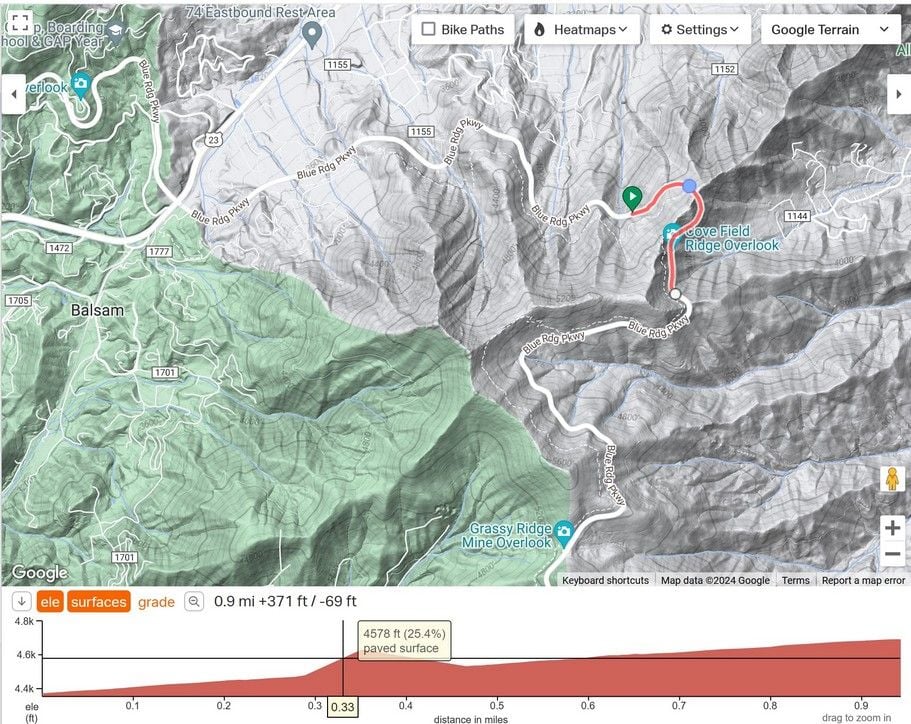
~~~
I ride lots of rolling terrain in OH, KY and Indiana. rwgps does best on routes that are reasonably flat along with hills. It can underestimate routes that have lots of small rolling hills.
It's rare that it overestimates the elevation, it's usually at least a little less.
rwgps can also be way off on the steepest parts of a climb. I've seen 8% where it's actually 14% for 50 feet of elevation.
What I typically expect:
fairly flat and some hill climbs included: rwgps says 1800 feet. I'll expect 1900 or so.
hills with lots of rolling terrain: rwgps 2200 feet. I expect around 2450. About 10% more
There's always a range of elevations for the group riders from their different recordings, but it's usually within 5% of each other.
For example, on the BRP. (with the paid rwgps version, there's a tool: "flatten elevation" that draws a straight elevation line between two points on the route. That can fix these spikes that can scare off some riders!)
just a steady grade through the tunnel, no 25% grades here!
~~~
I ride lots of rolling terrain in OH, KY and Indiana. rwgps does best on routes that are reasonably flat along with hills. It can underestimate routes that have lots of small rolling hills.
It's rare that it overestimates the elevation, it's usually at least a little less.
rwgps can also be way off on the steepest parts of a climb. I've seen 8% where it's actually 14% for 50 feet of elevation.
What I typically expect:
fairly flat and some hill climbs included: rwgps says 1800 feet. I'll expect 1900 or so.
hills with lots of rolling terrain: rwgps 2200 feet. I expect around 2450. About 10% more
There's always a range of elevations for the group riders from their different recordings, but it's usually within 5% of each other.
Last edited by rm -rf; 03-18-24 at 10:30 AM.
03-18-24, 10:23 AM
#9
Full Member
Thread Starter
Join Date: Jul 2018
Location: Raleigh, NC
Posts: 229
Mentioned: 1 Post(s)
Tagged: 0 Thread(s)
Quoted: 176 Post(s)
Liked 57 Times
in
36 Posts
So you feel that a few steep climbs are tougher than lots of rolling hills? Momentum can counteract rolling hills. Guess it's all about when the momentum slows and the real grind begins.
03-18-24, 10:30 AM
#10
I'm good to go!
Join Date: Jul 2017
Location: Mississippi
Posts: 14,992
Bikes: Tarmac Disc Comp Di2 - 2020
Mentioned: 51 Post(s)
Tagged: 0 Thread(s)
Quoted: 6196 Post(s)
Liked 4,811 Times
in
3,319 Posts
Maybe I could, but I've never been anywhere I could try out a 20% grade. The only decent 10% grade here makes me grunt and be glad it's over.
I can go up and down many 4% grades all day long. I have one short route I ride quite a bit with those 4% grades and accumulate 1600 - 1900 feet on it even though no one climb is more than about 20 - 50 feet of vertical elevation change.
Last edited by Iride01; 03-18-24 at 10:45 AM.
Likes For Iride01:
03-18-24, 10:47 AM
#11
Senior Member
I ride hilly and mountainous terrain in northern Colorado. I get relatively good agreement when I ride the same routes with 2-5000 feet of climbing. A peak elevation may vary by plus or minus feet 100 feet and total by a bit more. After riding each one dozens of times, I know what I'm in for. The worst gradient is what concerns me now. I'm carrying extra low gears since I'll soon be 71. I still weigh 135. My lowest two gear ratios are 30/38 and 30/44, compared to last year's 30/36. I probably won't use the lowest, but the 30/38 will certainly get used on the steepest sections. I keep the percent grade, gear combo and speed on display at all times.
Last edited by DaveSSS; 03-18-24 at 10:50 AM.
Likes For DaveSSS:
03-18-24, 12:41 PM
#12
Senior Member
Join Date: Jan 2023
Location: Eastern Shore MD
Posts: 884
Bikes: Lemond Zurich/Trek ALR/Giant TCX/Sette CX1
Mentioned: 1 Post(s)
Tagged: 0 Thread(s)
Quoted: 569 Post(s)
Liked 772 Times
in
404 Posts
Elevation tracking seems close enough for me - its the grade tracking that is lacking, seems to lag and not always be close enough to reality.
I do a local ride that's in a small valley and is surrounded by walls. 10-21+% - with the 16-20+++% sections being very short. Garmin will only register some of the peak grades well after the fact - not an issue because I know the route, but the first time up these climbs was surprising.
rwgps lists sections of these climbs as 3-8% - wrong.
gravel maps lists sections of the climbs at 35% - wrong.
I planned a gravel ride that crossed the blue ridge in PA - gravel maps had sections of the climb at 8% max. My Garmin had 17-20+% all the way up. Power meter, the need for all of the 40/44 gears and having to be out of the saddle just about the entire way told the real story.
None of them are correct all the time.
Likes For Jughed:
03-18-24, 03:34 PM
#13
Senior Member
Garmin probably only takes samples ever 5-10 seconds and will always report the grade that you've passed. It's good enough since you already know you're on a steep section. You just select your gear by feel.
Likes For DaveSSS:
03-19-24, 08:40 AM
#14
I'm good to go!
Join Date: Jul 2017
Location: Mississippi
Posts: 14,992
Bikes: Tarmac Disc Comp Di2 - 2020
Mentioned: 51 Post(s)
Tagged: 0 Thread(s)
Quoted: 6196 Post(s)
Liked 4,811 Times
in
3,319 Posts
I agree with DaveSSS that grade given real time on a Garmin or other device is probably useless unless you are on a long slope that doesn't change grade. And that isn't something that we have around me.
I don't have grade or elevation gain as a field on any of the data screens I use. And for the most part, like Calories, they are not useful numbers to know during a ride.
I don't have grade or elevation gain as a field on any of the data screens I use. And for the most part, like Calories, they are not useful numbers to know during a ride.
Likes For Iride01:
03-19-24, 09:57 AM
#15
don't try this at home.
Join Date: Jan 2006
Location: N. KY
Posts: 5,940
Mentioned: 10 Post(s)
Tagged: 0 Thread(s)
Quoted: 974 Post(s)
Liked 512 Times
in
352 Posts
Short steep grades on Garmin Edge:
There's a 6 second rolling average (so it averages the last 6 seconds)for the grade%. It's noticeable if I'm on a flat road, reaching a short steep pitch. Start up, and count: 1, 2, 3, 4, 5, 6 seconds -- now it says 12%. So there's always that delay before showing the steepest grade on the climb.
And it uses the barometer to track the elevation gain, and the bike road speed to calculate grade% from those two numbers. So variations in GPS signals can affect the grade% shown -- steep hillsides or lots of trees can affect the GPS location calcs. Even wind gusts can affect the barometer. For example, zooming down a steep valley and immediately climbing the other side can show an extreme grade%, since the strong air speed from the downhill drops to zero. So I find the grade% interesting, but not always accurate.
I do like seeing the grade% since it's often reasonably close on typical hills, within 1% or so. I've gotten pretty good at guessing the grade I'm on within 2%, just by feel / effort.
Last edited by rm -rf; 03-19-24 at 10:01 AM.
03-19-24, 10:15 AM
#16
Senior Member
Join Date: May 2021
Posts: 8,451
Mentioned: 12 Post(s)
Tagged: 0 Thread(s)
Quoted: 4415 Post(s)
Liked 4,867 Times
in
3,012 Posts
I don't need to see the current grade displayed as I can feel it. What I do like is Garmin's Climb Pro feature showing what I'm about to face. I find that works pretty well most of the time.
Likes For PeteHski:
03-19-24, 11:48 AM
#17
climber has-been

Join Date: Dec 2004
Location: Palo Alto, CA
Posts: 7,111
Bikes: Scott Addict R1, Felt Z1
Mentioned: 10 Post(s)
Tagged: 0 Thread(s)
Quoted: 3432 Post(s)
Liked 3,567 Times
in
1,793 Posts
I like the ClimbPro feature, also. It seems to be fairly accurate, but it can mess up where you currently are on the grade. If you're doing a stair step climb, it may show you on a steep bit when you are actually on a flat bit, and vice versa. The "distance to the summit" reading is a nice feature.
__________________
Ride, Rest, Repeat. ROUVY: terrymorse

Ride, Rest, Repeat. ROUVY: terrymorse
03-19-24, 12:36 PM
#18
Senior Member
Join Date: Jul 2009
Posts: 5,952
Bikes: Colnago, Van Dessel, Factor, Cervelo, Ritchey
Mentioned: 5 Post(s)
Tagged: 0 Thread(s)
Quoted: 3953 Post(s)
Liked 7,302 Times
in
2,948 Posts
Short steep grades on Garmin Edge:
There's a 6 second rolling average (so it averages the last 6 seconds)for the grade%. It's noticeable if I'm on a flat road, reaching a short steep pitch. Start up, and count: 1, 2, 3, 4, 5, 6 seconds -- now it says 12%. So there's always that delay before showing the steepest grade on the climb.
And it uses the barometer to track the elevation gain, and the bike road speed to calculate grade% from those two numbers. So variations in GPS signals can affect the grade% shown -- steep hillsides or lots of trees can affect the GPS location calcs. Even wind gusts can affect the barometer. For example, zooming down a steep valley and immediately climbing the other side can show an extreme grade%, since the strong air speed from the downhill drops to zero. So I find the grade% interesting, but not always accurate.
Likes For tomato coupe:
03-19-24, 12:47 PM
#19
don't try this at home.
Join Date: Jan 2006
Location: N. KY
Posts: 5,940
Mentioned: 10 Post(s)
Tagged: 0 Thread(s)
Quoted: 974 Post(s)
Liked 512 Times
in
352 Posts
I use the "Elevation" display page on my Edge 1030. It's the same on the 830 too.
This screen's elevation chart is divided into 4 vertical sections, with a grid line between them. My current location is always at the 1/4 line toward the left, with 3/4 showing upcoming terrain.
Following a route:
The advantage is there's just a chart, always scrolling as I ride. So I can see what's coming, not just the big climbs.
Like:
How far away is the base of the climb? Is it a mile ahead, or less than a quarter mile now?
What's after the top of the climb? Is it rolling, or a big downhill, or a flat and yet more climbing after?
Does the grade get steepest at the top, or does it ease off?
What's the trend ahead? I sometimes see rollers trending downhill, yeah!
How tall are these small climbs? Is the next one steeper?
Here comes that steep downhill into the river valley!
I have it set for 0.5 mile increments, so I see the previous half mile (to compare against what's coming next), and 1.5 miles ahead. The vertical grid is 200 feet. The 1030 shows 5x200 feet, the 830 shows 3x200 feet (or is it 4x200?)
At this scale, I get at least a mile warning of the start of the climb, and can estimate grades just by looking, within a couple percent. I can see the steepest portions of a mile long climb, and see if there's any easier "recovery zones" during the climb.
Zooming in, there's not enough distance ahead. Zooming way out, I can see the overall look of the ride, but the details are too tiny to show.
I'll leave this screen on display most of the time, instead of having data numbers or the map showing. (the turns pop up as I approach, as usual).
There's two data fields at the bottom, for grade%, speed, watts, heart rate, etc.
Likes For rm -rf:
03-19-24, 01:36 PM
#20
Senior Member
Join Date: May 2021
Posts: 8,451
Mentioned: 12 Post(s)
Tagged: 0 Thread(s)
Quoted: 4415 Post(s)
Liked 4,867 Times
in
3,012 Posts
I like the ClimbPro feature, also. It seems to be fairly accurate, but it can mess up where you currently are on the grade. If you're doing a stair step climb, it may show you on a steep bit when you are actually on a flat bit, and vice versa. The "distance to the summit" reading is a nice feature.
03-19-24, 01:39 PM
#21
Senior Member
Join Date: May 2021
Posts: 8,451
Mentioned: 12 Post(s)
Tagged: 0 Thread(s)
Quoted: 4415 Post(s)
Liked 4,867 Times
in
3,012 Posts
I use the "Elevation" display page on my Edge 1030. It's the same on the 830 too.
This screen's elevation chart is divided into 4 vertical sections, with a grid line between them. My current location is always at the 1/4 line toward the left, with 3/4 showing upcoming terrain.
.
This screen's elevation chart is divided into 4 vertical sections, with a grid line between them. My current location is always at the 1/4 line toward the left, with 3/4 showing upcoming terrain.
.
03-20-24, 09:25 AM
#22
don't try this at home.
Join Date: Jan 2006
Location: N. KY
Posts: 5,940
Mentioned: 10 Post(s)
Tagged: 0 Thread(s)
Quoted: 974 Post(s)
Liked 512 Times
in
352 Posts
Measuring those steepest grades. What is the real grade at that steepest spot?
from another thread Measuring Hills.
Actual Grade calc via a phone app
My Samsung phone has the android Bubble Level app on it. It's well designed, showing a bubble level along with a digital readout with the phone flat on the table, or a carpenter's level + readout if stood vertically on the bottom or side edge of the phone.
I have a very good 4 foot carpenter's level, and this app is within 1/10 percent of "0%" with the 4 foot level centered. It can display in degrees or slope percentage. It can be zeroed to any angle too.
My top tube slants front-to-back. With the bike on a known flat floor, with the phone base on the top tube and the phone edge against my stem, the bubble level shows "14.3 percent" slope toward the saddle.
I made a note of this for future reference. I can tilt the phone app to read "14.3" then press the Zero set button. Now, stopping on a hill, with the phone on the top tube as mentioned above, it reads the grade percentage directly.
I was interested in one of the notorious steeper hills in the area, and stopped during a downhill ride on that hill. Yes, it's steep: 22%. (It's very hard to completely stop on a 22% grade, and bike shoes aren't designed for this either!)
03-20-24, 10:33 AM
#23
your god hates me
Join Date: Apr 2006
Posts: 4,592
Bikes: 2016 Richard Sachs, 2010 Carl Strong, 2006 Cannondale Synapse
Mentioned: 10 Post(s)
Tagged: 0 Thread(s)
Quoted: 1254 Post(s)
Liked 1,287 Times
in
710 Posts
03-20-24, 10:40 AM
#24
Senior Member
Join Date: Jul 2009
Posts: 5,952
Bikes: Colnago, Van Dessel, Factor, Cervelo, Ritchey
Mentioned: 5 Post(s)
Tagged: 0 Thread(s)
Quoted: 3953 Post(s)
Liked 7,302 Times
in
2,948 Posts
GPS is not "overkill" for the job -- it's not as well suited for this application as a pressure transducer is.
Likes For tomato coupe:
03-20-24, 10:44 AM
#25
I'm good to go!
Join Date: Jul 2017
Location: Mississippi
Posts: 14,992
Bikes: Tarmac Disc Comp Di2 - 2020
Mentioned: 51 Post(s)
Tagged: 0 Thread(s)
Quoted: 6196 Post(s)
Liked 4,811 Times
in
3,319 Posts
As for GPS, the devices don't ping the satellite. The GPS in our Garmin and other devices is only a receiver And from the same GPS signals a altitude is calculated or can be calculated. Though few display that because the amount of error in that is quite a bit more than the 30 or so feet a GPS might be off in the horizontal position.
Last edited by Iride01; 03-20-24 at 10:49 AM.
Likes For Iride01: