


How many of these iconic roads have you ridden?
 03-13-18, 01:51 PM
#1

Let's do a Century
Thread Starter

Join Date: Oct 2004
Location: North Carolina
Posts: 8,316
Bikes: Cervelo R3 Disc, Pinarello Prince/Campy SR; Cervelo R3/Sram Red; Trek 5900/Duraace, Lynskey GR260 Ultegra
Mentioned: 59 Post(s)
Tagged: 0 Thread(s)
Quoted: 651 Post(s)
Liked 879 Times
in
408 Posts
How many of these iconic roads have you ridden?
I’ve been fortunate to have ridden some of these. Plans are to do Glacier in July.
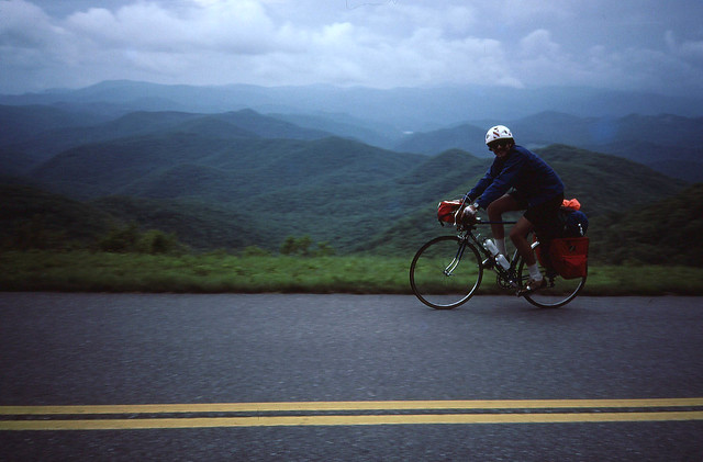
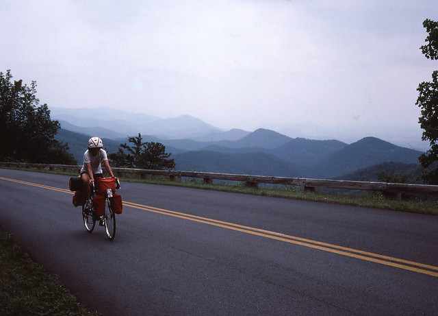
The Blue Ridge Parkway is nearby and I was fortunate to have ridden the entire length of it including Skyline Dr a couple years ago.
I’ve ridden Vail a few times. I’m not a big fan of paths, especially on descents.
https://blog.mapmyrun.com/7-worlds-iconic-bike-routes/?utm_source=mmf&utm_medium=email&utm_campaign=MMRide_Newsletter_20180313&os_ehash=55@sfmc:18443470
 03-15-18, 03:03 AM
#2

Spin Meister

None of them! :-(
However, I've done some challenging, iconic rides:
- Haleakala Crater, Maui, Hawaii, three years ago (sea level to 10,000 feet in one go).

Above: The top of the mountain (Haleakala Crater isn't actually a crater) is about 9,000 feet higher from where I made this photo, hiding behind clouds. It's a beautiful ride from start to finish.
- Three roads lead up to the Mt. Whitney Portal, Onion Valley and Tioga Pass from the floor of the high desert into the upper regions of the Sierra Nevada Mountains of California. I've pedaled up Tioga Pass several times and pedaled up the other two in 2016.
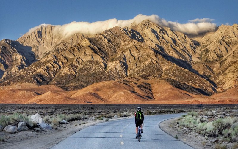
Above: the start of the ride up to Onion Valley, my brother leading the way.
- Stelvio Pass, Italy. The top is 16 miles with an average 8% gain in elevation and almost 6,000 feet of climbing, with 48 hairpin turns, most of them above tree line. The second highest paved road in Europe summits next to a glacier at a ski resort that's only open during the summer. I made the ride about four and a half years ago.

Above: This is one of the last hairpins. My brother was again my model.
- Fargo Street, Los Angeles. Just a 10th of a mile but with a 33% grade. The views from the top out over much of the city are almost worth the effort. I've made this ride countless times, at least once almost every year since 1978. I'm also the former record holder for most times up in one day on the annual Fargo Street Hill Climb.

Above: It's a steep climb up Fargo Street.
- Mulholland Highway from Leo Carrillo State Park, at the Pacific Ocean, to the Rock Store, a favorite destination for cyclists and motorcyclists alike. The ride travels over almost 16 twisting, up, up and up and miles, with a great few downhills. Much of the way highway leads through ruggedly beautiful state parklands. And there are beautiful views over the Santa Monica Mountains, the city of Los Angeles and beyond. I made this ride last year.

Above: Mulholland Highway, a few miles east of its starting point, leads past some spectacular scenery. Bony Ridge is in the background.
- Bonus ride: The Hollywood Sign, in Los Angeles. It's not a long ride from where cars have to stop and bikes - and pedestrians - can continue up to the top of the sign, where there are mind-blowing views of the city and surrounding geography. It become a very steep ride, though. I've made the ascent many times over many years.

Above: That's me, with the city of Burbank far below me, with several hundred yards to climb to reach the end of the ride.
However, I've done some challenging, iconic rides:
- Haleakala Crater, Maui, Hawaii, three years ago (sea level to 10,000 feet in one go).
Above: The top of the mountain (Haleakala Crater isn't actually a crater) is about 9,000 feet higher from where I made this photo, hiding behind clouds. It's a beautiful ride from start to finish.
- Three roads lead up to the Mt. Whitney Portal, Onion Valley and Tioga Pass from the floor of the high desert into the upper regions of the Sierra Nevada Mountains of California. I've pedaled up Tioga Pass several times and pedaled up the other two in 2016.
Above: the start of the ride up to Onion Valley, my brother leading the way.
- Stelvio Pass, Italy. The top is 16 miles with an average 8% gain in elevation and almost 6,000 feet of climbing, with 48 hairpin turns, most of them above tree line. The second highest paved road in Europe summits next to a glacier at a ski resort that's only open during the summer. I made the ride about four and a half years ago.
Above: This is one of the last hairpins. My brother was again my model.
- Fargo Street, Los Angeles. Just a 10th of a mile but with a 33% grade. The views from the top out over much of the city are almost worth the effort. I've made this ride countless times, at least once almost every year since 1978. I'm also the former record holder for most times up in one day on the annual Fargo Street Hill Climb.
Above: It's a steep climb up Fargo Street.
- Mulholland Highway from Leo Carrillo State Park, at the Pacific Ocean, to the Rock Store, a favorite destination for cyclists and motorcyclists alike. The ride travels over almost 16 twisting, up, up and up and miles, with a great few downhills. Much of the way highway leads through ruggedly beautiful state parklands. And there are beautiful views over the Santa Monica Mountains, the city of Los Angeles and beyond. I made this ride last year.
Above: Mulholland Highway, a few miles east of its starting point, leads past some spectacular scenery. Bony Ridge is in the background.
- Bonus ride: The Hollywood Sign, in Los Angeles. It's not a long ride from where cars have to stop and bikes - and pedestrians - can continue up to the top of the sign, where there are mind-blowing views of the city and surrounding geography. It become a very steep ride, though. I've made the ascent many times over many years.
Above: That's me, with the city of Burbank far below me, with several hundred yards to climb to reach the end of the ride.
__________________
This post is a natural product. Slight variations in spelling and grammar enhance its individual character and beauty and are in no way to be considered flaws or defects.
This post is a natural product. Slight variations in spelling and grammar enhance its individual character and beauty and are in no way to be considered flaws or defects.
Last edited by icyclist; 03-15-18 at 02:19 PM.
03-16-18, 01:00 AM
#3
Senior Member
Join Date: Jan 2010
Location: Eugene, Oregon
Posts: 7,048
Mentioned: 10 Post(s)
Tagged: 0 Thread(s)
Quoted: 509 Post(s)
Likes: 0
Liked 9 Times
in
8 Posts
I've only been off the N. American continent once, and that was to Hawaii. However, I have ridden two of the three on this continent, both with full touring loads. I never did manage to get over to Montana.
Fun stuff, these lists. I imagine many of us could put together equally nice lists of great rides, though many of our choices would likely be far less famous.
Fun stuff, these lists. I imagine many of us could put together equally nice lists of great rides, though many of our choices would likely be far less famous.
03-16-18, 03:48 AM
#4
In Real Life

Join Date: Jan 2003
Location: Down under down under
Posts: 52,152
Bikes: Lots
Mentioned: 141 Post(s)
Tagged: 0 Thread(s)
Quoted: 3203 Post(s)
Liked 599 Times
in
331 Posts
Great Ocean Road ... several times.
__________________
Rowan
My fave photo threads on BF
Century A Month Facebook Group
Machka's Website
Photo Gallery
Rowan
My fave photo threads on BF
Century A Month Facebook Group
Machka's Website
Photo Gallery
03-16-18, 04:51 AM
#5
Senior Member
I did Going to the Sun Road/Logan Pass in Glacier last year - we did it in June when they were still plowing snow but on weekeds bike (but not cars!) were allowed on the western side up to Logan Pass. It was in the 60s and not a cloud in the sky - just an amazing climb/ride.
I live in Maryland, have done sections of Blue Ridge Parkway and Skyline Drive. Once a year they shut down the northern part of Skyline Drive to cars but I've never been able to ride that day.
I live in Maryland, have done sections of Blue Ridge Parkway and Skyline Drive. Once a year they shut down the northern part of Skyline Drive to cars but I've never been able to ride that day.
03-16-18, 08:28 AM
#6
Seat Sniffer

Join Date: Sep 2007
Location: SoCal
Posts: 5,659
Bikes: Serotta Legend Ti; 2006 Schwinn Fastback Pro and 1996 Colnago Decor Super C96; 2003 Univega Alpina 700; 2000 Schwinn Super Sport
Mentioned: 18 Post(s)
Tagged: 0 Thread(s)
Quoted: 956 Post(s)
Liked 2,109 Times
in
594 Posts
03-16-18, 09:29 AM
#7
Senior Member
I haven't done any thus far, but by this time next year, prayerfully I would have done two, Blue Ridge Parkway in June and Great Ocean Road in January '19. Since these are already planned family trips with my wife (she doesn't cycle) I'll probably only do about 30 or so miles on each route since I would only be able to slip away for a couple of hours without upsetting the "vacation" apple cart. But at least I'll be able to say I've done it, right? 
03-16-18, 10:33 AM
#8
It's MY mountain

Join Date: Sep 2006
Location: Mt.Diablo
Posts: 10,010
Bikes: Klein, Merckx, Trek
Mentioned: 70 Post(s)
Tagged: 0 Thread(s)
Quoted: 4382 Post(s)
Liked 3,054 Times
in
1,653 Posts
Friend of mine rode Alpe d'Huez as part of a TdF spectator tour and gave me a live shoutout on international TV

03-16-18, 11:19 AM
#9
Senior Member

I’ve been fortunate to have ridden some of these. Plans are to do Glacier in July.
The Blue Ridge Parkway is nearby and I was fortunate to have ridden the entire length of it including Skyline Dr a couple years ago.
I’ve ridden Vail a few times. I’m not a big fan of paths, especially on descents.
7 of the World?s Most Iconic Bike Routes | MapMyRun
The Blue Ridge Parkway is nearby and I was fortunate to have ridden the entire length of it including Skyline Dr a couple years ago.
I’ve ridden Vail a few times. I’m not a big fan of paths, especially on descents.
7 of the World?s Most Iconic Bike Routes | MapMyRun
(Sorry, not trying to hijack this thread)
03-16-18, 04:35 PM
#10
Senior Member

Join Date: Jul 2002
Location: Sacramento, California, USA
Posts: 40,865
Bikes: Specialized Tarmac, Canyon Exceed, Specialized Transition, Ellsworth Roots, Ridley Excalibur
Mentioned: 68 Post(s)
Tagged: 0 Thread(s)
Quoted: 2953 Post(s)
Liked 3,106 Times
in
1,417 Posts
None of them! :-(
However, I've done some challenging, iconic rides:
- Haleakala Crater, Maui, Hawaii, three years ago (sea level to 10,000 feet in one go).
Above: The top of the mountain (Haleakala Crater isn't actually a crater) is about 9,000 feet higher from where I made this photo, hiding behind clouds. It's a beautiful ride from start to finish.
- Three roads lead up to the Mt. Whitney Portal, Onion Valley and Tioga Pass from the floor of the high desert into the upper regions of the Sierra Nevada Mountains of California. I've pedaled up Tioga Pass several times and pedaled up the other two in 2016.
Above: the start of the ride up to Onion Valley, my brother leading the way.
- Stelvio Pass, Italy. The top is 16 miles with an average 8% gain in elevation and almost 6,000 feet of climbing, with 48 hairpin turns, most of them above tree line. The second highest paved road in Europe summits next to a glacier at a ski resort that's only open during the summer. I made the ride about four and a half years ago.
Above: This is one of the last hairpins. My brother was again my model.
- Fargo Street, Los Angeles. Just a 10th of a mile but with a 33% grade. The views from the top out over much of the city are almost worth the effort. I've made this ride countless times, at least once almost every year since 1978. I'm also the former record holder for most times up in one day on the annual Fargo Street Hill Climb.
Above: It's a steep climb up Fargo Street.
- Mulholland Highway from Leo Carrillo State Park, at the Pacific Ocean, to the Rock Store, a favorite destination for cyclists and motorcyclists alike. The ride travels over almost 16 twisting, up, up and up and miles, with a great few downhills. Much of the way highway leads through ruggedly beautiful state parklands. And there are beautiful views over the Santa Monica Mountains, the city of Los Angeles and beyond. I made this ride last year.
Above: Mulholland Highway, a few miles east of its starting point, leads past some spectacular scenery. Bony Ridge is in the background.
- Bonus ride: The Hollywood Sign, in Los Angeles. It's not a long ride from where cars have to stop and bikes - and pedestrians - can continue up to the top of the sign, where there are mind-blowing views of the city and surrounding geography. It become a very steep ride, though. I've made the ascent many times over many years.
Above: That's me, with the city of Burbank far below me, with several hundred yards to climb to reach the end of the ride.
 03-16-18, 04:57 PM
#11
In the wind
I've done Alp d'Huez and Going to the sun.
Places I'd add to the list:
Mt. Ventoux
Icefields Parkway
Highwood Pass

Places I'd add to the list:
Mt. Ventoux
Icefields Parkway
Highwood Pass
03-16-18, 07:46 PM
#13
Senior Member
None of them! :-(
However, I've done some challenging, iconic rides:
- Haleakala Crater, Maui, Hawaii, three years ago (sea level to 10,000 feet in one go).
Above: The top of the mountain (Haleakala Crater isn't actually a crater) is about 9,000 feet higher from where I made this photo, hiding behind clouds. It's a beautiful ride from start to finish.
- Three roads lead up to the Mt. Whitney Portal, Onion Valley and Tioga Pass from the floor of the high desert into the upper regions of the Sierra Nevada Mountains of California. I've pedaled up Tioga Pass several times and pedaled up the other two in 2016.
Above: the start of the ride up to Onion Valley, my brother leading the way.
- Stelvio Pass, Italy. The top is 16 miles with an average 8% gain in elevation and almost 6,000 feet of climbing, with 48 hairpin turns, most of them above tree line. The second highest paved road in Europe summits next to a glacier at a ski resort that's only open during the summer. I made the ride about four and a half years ago.
Above: This is one of the last hairpins. My brother was again my model.
- Fargo Street, Los Angeles. Just a 10th of a mile but with a 33% grade. The views from the top out over much of the city are almost worth the effort. I've made this ride countless times, at least once almost every year since 1978. I'm also the former record holder for most times up in one day on the annual Fargo Street Hill Climb.
Above: It's a steep climb up Fargo Street.
- Mulholland Highway from Leo Carrillo State Park, at the Pacific Ocean, to the Rock Store, a favorite destination for cyclists and motorcyclists alike. The ride travels over almost 16 twisting, up, up and up and miles, with a great few downhills. Much of the way highway leads through ruggedly beautiful state parklands. And there are beautiful views over the Santa Monica Mountains, the city of Los Angeles and beyond. I made this ride last year.
Above: Mulholland Highway, a few miles east of its starting point, leads past some spectacular scenery. Bony Ridge is in the background.
- Bonus ride: The Hollywood Sign, in Los Angeles. It's not a long ride from where cars have to stop and bikes - and pedestrians - can continue up to the top of the sign, where there are mind-blowing views of the city and surrounding geography. It become a very steep ride, though. I've made the ascent many times over many years.
Above: That's me, with the city of Burbank far below me, with several hundred yards to climb to reach the end of the ride.
However, I've done some challenging, iconic rides:
- Haleakala Crater, Maui, Hawaii, three years ago (sea level to 10,000 feet in one go).
Above: The top of the mountain (Haleakala Crater isn't actually a crater) is about 9,000 feet higher from where I made this photo, hiding behind clouds. It's a beautiful ride from start to finish.
- Three roads lead up to the Mt. Whitney Portal, Onion Valley and Tioga Pass from the floor of the high desert into the upper regions of the Sierra Nevada Mountains of California. I've pedaled up Tioga Pass several times and pedaled up the other two in 2016.
Above: the start of the ride up to Onion Valley, my brother leading the way.
- Stelvio Pass, Italy. The top is 16 miles with an average 8% gain in elevation and almost 6,000 feet of climbing, with 48 hairpin turns, most of them above tree line. The second highest paved road in Europe summits next to a glacier at a ski resort that's only open during the summer. I made the ride about four and a half years ago.
Above: This is one of the last hairpins. My brother was again my model.
- Fargo Street, Los Angeles. Just a 10th of a mile but with a 33% grade. The views from the top out over much of the city are almost worth the effort. I've made this ride countless times, at least once almost every year since 1978. I'm also the former record holder for most times up in one day on the annual Fargo Street Hill Climb.
Above: It's a steep climb up Fargo Street.
- Mulholland Highway from Leo Carrillo State Park, at the Pacific Ocean, to the Rock Store, a favorite destination for cyclists and motorcyclists alike. The ride travels over almost 16 twisting, up, up and up and miles, with a great few downhills. Much of the way highway leads through ruggedly beautiful state parklands. And there are beautiful views over the Santa Monica Mountains, the city of Los Angeles and beyond. I made this ride last year.
Above: Mulholland Highway, a few miles east of its starting point, leads past some spectacular scenery. Bony Ridge is in the background.
- Bonus ride: The Hollywood Sign, in Los Angeles. It's not a long ride from where cars have to stop and bikes - and pedestrians - can continue up to the top of the sign, where there are mind-blowing views of the city and surrounding geography. It become a very steep ride, though. I've made the ascent many times over many years.
Above: That's me, with the city of Burbank far below me, with several hundred yards to climb to reach the end of the ride.
 03-16-18, 07:58 PM
#14
don't try this at home.

Join Date: Jan 2006
Location: N. KY
Posts: 5,991
Mentioned: 10 Post(s)
Tagged: 0 Thread(s)
Quoted: 989 Post(s)
Liked 536 Times
in
368 Posts
I haven't done any thus far, but by this time next year, prayerfully I would have done two, Blue Ridge Parkway in June and Great Ocean Road in January '19. Since these are already planned family trips with my wife (she doesn't cycle) I'll probably only do about 30 or so miles on each route since I would only be able to slip away for a couple of hours without upsetting the "vacation" apple cart. But at least I'll be able to say I've done it, right?
Pinnacle Ridge to Pisgah Inn route
Zoom in and check out the terrain!
Sept 2009 photo album.
The ridewithgps route doesn't know about the tunnels, so it shows the route going over the tunnel ridges with short, steep climbs. See mile 17 and mile 29 tunnels. The max grade is mostly under 8%, often 6% or less, perhaps with a few short sections that reach 9% or so. Downhills rarely need braking, with wide, sweeping turns.
Or start at Richland Balsam for a 45 mile, 5200 foot ride, or one of the many overlooks near the beginning of the ride. But you miss the final downhill at the end.
Still too much? Start at the Pisgah Inn and ride to the Caney Fork overlook. Out and back is 39 miles, 4300 feet, and a big downhill on the return. (no water is available, bring two bottles.)
Pisgah Inn to Caney Fork overlook
Your non-rider wife can spend the day in Asheville, there's lots to do there.
Last edited by rm -rf; 03-16-18 at 08:07 PM.
03-16-18, 09:06 PM
#15
rebmeM roineS

Join Date: Jan 2006
Location: Metro Indy, IN
Posts: 16,216
Bikes: Bacchetta Giro A20, RANS V-Rex, RANS Screamer
Mentioned: 15 Post(s)
Tagged: 0 Thread(s)
Quoted: 653 Post(s)
Liked 348 Times
in
227 Posts
Rode most of the Blue Ridge Parkway in 1981 with wife/future stoker as part of an adventure from Atlanta to New Hampshire to Milwaukee.
__________________
Bacchetta Giro A20, RANS V-Rex, RANS Screamer
Bacchetta Giro A20, RANS V-Rex, RANS Screamer
03-16-18, 10:19 PM
#16
Let's do a Century
Thread Starter
Join Date: Oct 2004
Location: North Carolina
Posts: 8,316
Bikes: Cervelo R3 Disc, Pinarello Prince/Campy SR; Cervelo R3/Sram Red; Trek 5900/Duraace, Lynskey GR260 Ultegra
Mentioned: 59 Post(s)
Tagged: 0 Thread(s)
Quoted: 651 Post(s)
Liked 879 Times
in
408 Posts
We went North to South in May 2015. Perfect weather every day and minimal traffic except around Asheville. Great views since leaves were off the trees. We started on a Sunday and finished the next Saturday. We did all of Skyline Dr the first day which was 115 miles and over 10,000’ of climbing. All total it was almost 600 miles and 60,000’ of climbing. My wife sagged for us so we didn’t have to worry about fluids....except when she went hiking one day and was really late to our meeting spot! You should do it.
03-17-18, 07:09 AM
#18
In the wind
Yeah, that's me coming off the Highwood pass a couple of years ago. From my house, it's a double century. Light traffic, smooth pavement and good shoulders.
03-17-18, 07:55 AM
#19
Senior Member
Join Date: Jul 2004
Location: northern michigan
Posts: 13,319
Bikes: '77 Colnago Super, '76 Fuji The Finest, '88 Cannondale Criterium, '86 Trek 760, '87 Miyata 712
Mentioned: 19 Post(s)
Tagged: 0 Thread(s)
Quoted: 660 Post(s)
Liked 601 Times
in
314 Posts
M-32 in Northern Lower Michigan. We have our own flavor of iconic.
03-17-18, 10:01 AM
#21
Senior Member
We went North to South in May 2015. Perfect weather every day and minimal traffic except around Asheville. Great views since leaves were off the trees. We started on a Sunday and finished the next Saturday. We did all of Skyline Dr the first day which was 115 miles and over 10,000’ of climbing. All total it was almost 600 miles and 60,000’ of climbing. My wife sagged for us so we didn’t have to worry about fluids....except when she went hiking one day and was really late to our meeting spot! You should do it.
Planning on an Outer Banks Loop in April. Probably my only trip this Spring. Maybe the BRP would be a good target for early next Spring.
03-18-18, 02:40 PM
#22
feros ferio

Join Date: Jul 2000
Location: www.ci.encinitas.ca.us
Posts: 21,847
Bikes: 1959 Capo Modell Campagnolo; 1960 Capo Sieger (2); 1962 Carlton Franco Suisse; 1970 Peugeot UO-8; 1982 Bianchi Campione d'Italia; 1988 Schwinn Project KOM-10;
Mentioned: 44 Post(s)
Tagged: 0 Thread(s)
Quoted: 1409 Post(s)
Liked 1,366 Times
in
859 Posts
Pacific Coast Highway "Surf Route 101" numerous times, from Oceanside to downtown San Diego
When I lived in west Los Angeles, I regularly did Mulholland Dr., also PCH south as far as Huntington Beach, north as far as Pt. Mugu.
My favorite epic climb, no longer legal since it is now a one-way downhill street, was Tuna Canyon in Malibu. I am glad I got in 8 ascents before I moved out of the area and they regrettably closed it to all uphill traffic. Megabummer!
__________________
"Far and away the best prize that life offers is the chance to work hard at work worth doing." --Theodore Roosevelt
Capo: 1959 Modell Campagnolo, S/N 40324; 1960 Sieger (2), S/N 42624, 42597
Carlton: 1962 Franco Suisse, S/N K7911
Peugeot: 1970 UO-8, S/N 0010468
Bianchi: 1982 Campione d'Italia, S/N 1.M9914
Schwinn: 1988 Project KOM-10, S/N F804069
03-18-18, 03:36 PM
#23
Banned
Found myself on the start-grid finish line of the Spa Francorships GP race course on my Bike tour from Strasbourg. west to the Belgian Coast..
03-18-18, 07:49 PM
#24
Senior Member
Here's my favorite Blue Ridge Parkway ride. 62 miles and 7000 feet. It includes the highest point on the Parkway, Richland Balsam at elevation 6050 feet. It mostly runs along the crests of the mountains, so there's alternating great views on either side, and lots of overlooks to make brief stops. At the turnaround, get water refills and carryout lunch at the Pisgah Inn, or snacks at the camping store. The restaurant also has a good, inexpensive breakfast, and the dining room has view way across the valley below.
Pinnacle Ridge to Pisgah Inn route
Zoom in and check out the terrain!
Sept 2009 photo album.
The ridewithgps route doesn't know about the tunnels, so it shows the route going over the tunnel ridges with short, steep climbs. See mile 17 and mile 29 tunnels. The max grade is mostly under 8%, often 6% or less, perhaps with a few short sections that reach 9% or so. Downhills rarely need braking, with wide, sweeping turns.
Or start at Richland Balsam for a 45 mile, 5200 foot ride, or one of the many overlooks near the beginning of the ride. But you miss the final downhill at the end.
Still too much? Start at the Pisgah Inn and ride to the Caney Fork overlook. Out and back is 39 miles, 4300 feet, and a big downhill on the return. (no water is available, bring two bottles.)
Pisgah Inn to Caney Fork overlook
Your non-rider wife can spend the day in Asheville, there's lots to do there.
03-19-18, 11:59 AM
#25
Senior Member
Join Date: Jan 2010
Posts: 39,663
Mentioned: 211 Post(s)
Tagged: 1 Thread(s)
Quoted: 18595 Post(s)
Liked 16,088 Times
in
7,551 Posts
I've climbed the west slope of Going to the Sun four times, descended it three times and descended the east slope once. Last time up and back down the west side was last June.